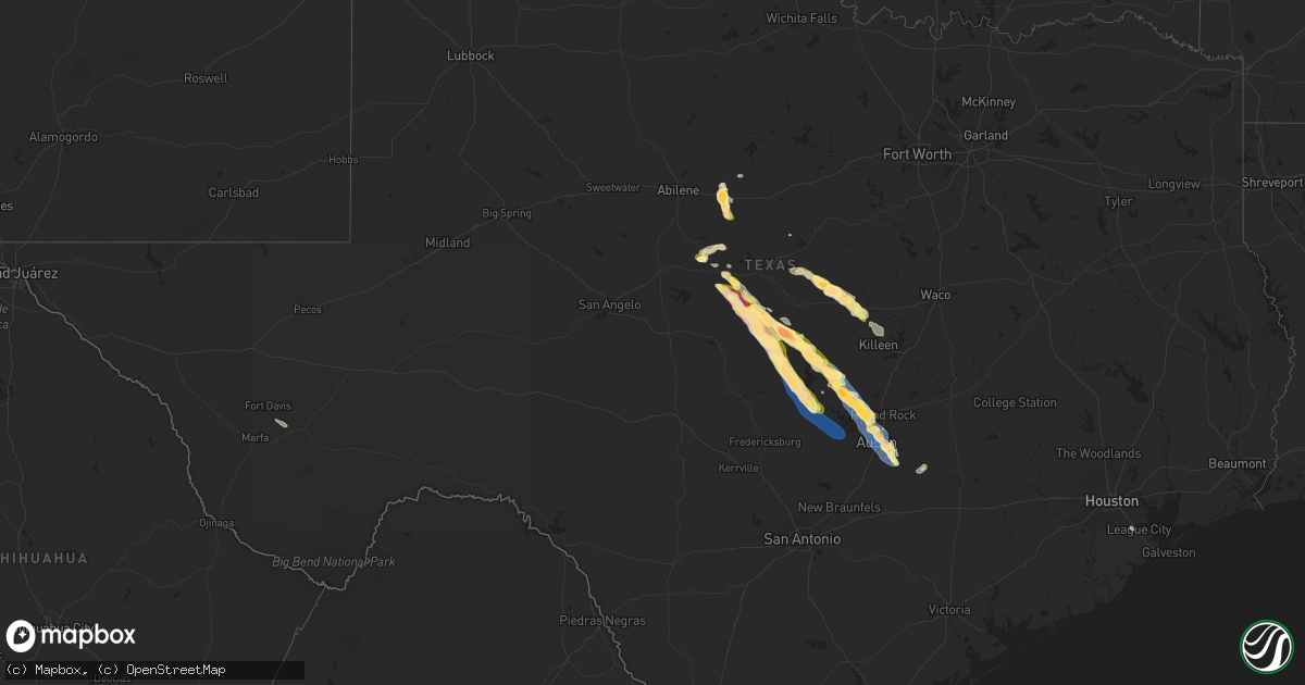
Hail Map in Texas on May 28, 2025
Get this storm
May 28 map
$229
one time, instant access
Download today. No call, no setup
Keep the $229
Bought the map and want the full workflow? Apply the entire $229 to a subscription within 7 days. None of it is wasted.
Every map, not just this one
This buys you this map. Subscription and you get every map we run, in the markets you choose from a few cities to whole states to nationwide. Plus real-time alerts the moment a storm fires.
Contact data
Name, contact info, occupancy, even credit band for addresses in the footprint. You go from where it hit to who to call.
Become the source they trust
Unlimited branding weather history reports on demand. You already have the documented answer ready for the property owner, and you are the one who showed up with it.
Property data and RoofTrace estimates
Pull up any address you have got, its value and the exact code rules for that jurisdiction, straight from One Click Code. Then RoofTrace estimates the squares, pitch, and roof value, priced the way you price.
Storm reports in Texas
Texas
| Date | Description |
|---|---|
| 05/28/20256:59 PM CDT | Asos station kaus austin-bergstrom international airport. |
| 05/28/20256:57 PM CDT | Glass doorway broken at barbara jordan terminal. Time estimated via radar. |
| 05/28/20256:50 PM CDT | A local report indicates 1.25 inch wind near Richland Springs |
| 05/28/20256:50 PM CDT | Numerous downed... Uprooted... And snapped trees in east austin. Damage to siding and windows of homes. |
| 05/28/20256:50 PM CDT | Weatherstem unit measured 65 mph at the university of texas at austin. |
| 05/28/20256:48 PM CDT | A local report indicates 1.25 inch wind near Richland Springs |
| 05/28/20256:45 PM CDT | Social media picture of an split tree trunk that was about 8 inches in diameter on the north plaza of the capitol building at 15th street. Time estimated from radar. |
| 05/28/20256:40 PM CDT | Numerous uprooted and snapped trees in north central austin including the hyde park and rosedale neighborhoods. |
| 05/28/20256:38 PM CDT | Social media picture of a downed mature tree off metric boulevard near the domain in nw austin. Time estimated by radar. |
| 05/28/20256:38 PM CDT | Pea to quarter sized hail. Time estimated via radar. |
| 05/28/20256:30 PM CDT | Loss of roof panels from gas station roof canopy. Time estimated via radar. |
| 05/28/20256:30 PM CDT | A local report indicates 1.00 inch wind near 6 N Austin |
| 05/28/20256:20 PM CDT | Corrects previous hail report from 2 w cedar park. Picture of golf ball size hail on social media. |
| 05/28/20256:16 PM CDT | Multiple photos of 1.5 inch hail on social media. |
| 05/28/20256:08 PM CDT | Photo with ruler of 1.5 inch hail. Time estimated via radar. |
| 05/28/20256:06 PM CDT | Photo received from public. Size estimated through comparison with penny. Time estimated via radar. |
| 05/28/20256:06 PM CDT | Amateur radio reports qu |
| 05/28/20256:06 PM CDT | Amateur radio reports quarter sized hail at park street and u.s. 183. |
| 05/28/20256:04 PM CDT | A local report indicates 1.00 inch wind near 1 NNE Winchell |
| 05/28/20256:02 PM CDT | Amateur radio operator reports quarter sized hail. |
| 05/28/20256:00 PM CDT | Report from mping half dollar |
| 05/28/20256:00 PM CDT | Nickel to chicken egg size hail for 20 minutes. |
| 05/28/20255:56 PM CDT | Hail up to 1.5 inch with leaf shredding. |
| 05/28/20255:45 PM CDT | Mesonet station bfxt2 balcones flying x. Time estimated by radar. |
| 05/28/20255:40 PM CDT | Cocorahs observer reports pea to quarter sized hail. |
| 05/28/20255:35 PM CDT | Media relayed a picture from the public of 2 inch hail. Time estimated from radar. |
| 05/28/20255:30 PM CDT | County emergency manager relayed a report of quarter to half dollar size hail in bertram. |
| 05/28/20254:24 PM CDT | Ping pong ball size hail at colorado bend state park. |
| 05/28/20254:05 PM CDT | A local report indicates 1.75 inch wind near 4 N Chappel |
| 05/28/20254:00 PM CDT | Golf ball to baseball size hail along us-190 east of san saba. |
| 05/28/20253:45 PM CDT | Reported on facebook. |
| 05/28/20253:40 PM CDT | A local report indicates 1.50 inch wind near Evant |
| 05/28/20253:30 PM CDT | Baseball size hail reported off county road 513. Relayed by amateur radio. |
| 05/27/20259:08 PM CDT | Spotter measured 3.24 inch hail about 8 miles south of follett. This hail was found after the storm moved through and likely had so |
| 05/27/20259:08 PM CDT | Spotter measured 3.24 inch hail about 8 miles south of follett. This hail was found after the storm moved through and likely had some melting occurring so max hail size |
| 05/27/20259:06 PM CDT | Spotter network report of a measured hailstone of 3.4 inches. This likely was measured with some melting having occurred. |
| 05/27/20259:06 PM CDT | Ping pong ball size hail fell along fm1454 between follett and higgins. |
| 05/27/20258:36 PM CDT | Baseball size hail fell west of follett. Video of a storm spotter shows broken windshield. |
| 05/27/20258:35 PM CDT | Mesonet station fw7339 kingsland. |
| 05/27/20258:32 PM CDT | Report from mping: golf ball |
| 05/27/20258:30 PM CDT | A local report indicates 1.25 inch wind near Darrouzett |
| 05/27/20258:28 PM CDT | Quarter size hail reported in kingsland with 40 mph wind gusts. Time estimated via radar. |
| 05/27/20258:26 PM CDT | 5 power poles downed in the rm 1431 and rm 2545 area. Power outages reported. Time estimated via radar. |
| 05/27/20258:25 PM CDT | A local report indicates 2.00 inch wind near Darrouzett |
| 05/27/20258:24 PM CDT | A local report indicates 2.00 inch wind near 2 W Darrouzett |
| 05/27/20257:51 PM CDT | Report from mping. Time estimated via radar. |
| 05/27/20257:40 PM CDT | A local report indicates 1.50 inch wind near 8 SW San Saba |
All States Impacted by Hail Map on May 28, 2025
Cities Impacted by Hail Map on May 28, 2025
- Smithville, TX
- Bastrop, TX
- League City, TX
- Port Isabel, TX
- Friendswood, TX
- Webster, TX
- West Palm Beach, FL
- Wellington, FL
- Loxahatchee, FL
- De Leon, TX
- Colorado Springs, CO
- Comanche, TX
- Peyton, CO
- Rochelle, TX
- Gustine, TX
- Mullin, TX
- Priddy, TX
- Brownwood, TX
- Richland Springs, TX
- Hamilton, TX
- Springfield, LA
- Livingston, LA
- Belle Rose, LA
- Napoleonville, LA
- Pierre Part, LA
- Bethune, CO
- Pottsville, TX
- Burlington, CO
- Grenville, NM
- San Saba, TX
- Wauchula, FL
- Fort Pierce, FL
- Goldthwaite, TX
- Myakka City, FL
- Kenton, OK
- Evant, TX
- Carriere, MS
- Picayune, MS
- Clayton, NM
- Baton Rouge, LA
- Pride, LA
- Zachary, LA
- Baker, LA
- Manter, KS
- Lometa, TX
- Purmela, TX
- Des Moines, NM
- Amite, LA
- Port Saint Lucie, FL
- Wray, CO
- Moran, TX
- Campo, CO
- Walsh, CO
- Greenwell Springs, LA
- Poplarville, MS
- Kingsland, GA
- Johnson, KS
- Model, CO
- Trinidad, CO
- Bend, TX
- Lampasas, TX
- Jonesboro, TX
- Gatesville, TX
- Kentwood, LA
- Roseland, LA
- Greensburg, LA
- Saint Marys, GA
- Kings Bay, GA
- Baird, TX
- Brooklyn, MS
- Indiantown, FL
- Haigler, NE
- Mount Hermon, LA
- Arapahoe, CO
- Cheyenne Wells, CO
- Ulysses, KS
- Burnet, TX
- Lumberton, MS
- Hattiesburg, MS
- Saint Francis, KS
- Coleman, TX
- Venus, FL
- Syracuse, KS
- Lake Placid, FL
- Purvis, MS
- Lakeland, FL
- Fort Hood, TX
- Tylertown, MS
- Jacksonville, FL
- Osyka, MS
- Leakesville, MS
- Richton, MS
- Franklinton, LA
- Forgan, OK
- Santa Anna, TX
- Jacksonville Beach, FL
- Bertram, TX
- Cisco, TX
- Cross Plains, TX
- Hooker, OK
- Hugoton, KS
- Lakin, KS
- Ponte Vedra Beach, FL
- Liberty Hill, TX
- Leander, TX
- Tibbie, AL
- Wagarville, AL
- Sumrall, MS
- Brookesmith, TX
- Leoti, KS
- Bangs, TX
- Meade, KS
- Deerfield, KS
- Sheridan Lake, CO
- Marble Falls, TX
- Satanta, KS
- Cedar Park, TX
- Austin, TX
- Gate, OK
- Scott City, KS
- Plains, KS
- Boone, CO
- Liberal, KS
- Burkett, TX
- Rolla, KS
- Coolidge, KS
- Palm Coast, FL
- Tyrone, OK
- Dalhart, TX
- Texhoma, OK
- Kismet, KS
- Castleberry, AL
- Evergreen, AL
- Fountain, CO
- Round Rock, TX
- Turpin, OK
- Bunnell, FL
- Del Valle, TX
- Kim, CO
- Holly, CO
- Lamar, CO
- Wiley, CO
- Hasty, CO
- Las Animas, CO
- Beaver, OK
- Offerle, KS
- Red Level, AL
- Andalusia, AL
- Alpine, TX
- Kendall, KS
- Florissant, CO
- Saint Stephens, AL
- Laverne, OK
- Deer Park, AL
- Cedar Creek, TX
- Manor, TX
- La Junta, CO
- Dale, TX
- Cherokee, TX
- Balko, OK
- Kinsley, KS
- Greensburg, KS
- Mullinville, KS
- Follett, TX
- Shattuck, OK
- Llano, TX
- Haviland, KS
- Ozark, AL
- Valley Spring, TX
- Bluffton, TX
- Tow, TX
- Buchanan Dam, TX
- Dodge City, KS
- Pritchett, CO
- Wright, KS
- Burdett, KS
- Booker, TX
- Darrouzett, TX
- Perryton, TX
- Kingsland, TX
- Stinnett, TX
- Ford, KS
- Canon City, CO
- Moscow, KS
- Horseshoe Bay, TX
- Elkhart, KS
- Penrose, CO
- Gulfport, MS
- Gage, OK
- Fargo, OK
- Higgins, TX
- Round Mountain, TX
- Spicewood, TX
- Johnson City, TX
- Dripping Springs, TX
- Biloxi, MS
- Woodward, OK
- Canadian, TX
- Wilmore, KS
- Arnett, OK
- Mooreland, OK
- Cheney, KS
- Kingman, KS
- Murdock, KS
- Goddard, KS
- Viola, KS
- Garden Plain, KS
- Clearwater, KS
- Milton, KS
- Norwich, KS
- Haysville, KS
- Conway Springs, KS
- Mayfield, KS
- Pretty Prairie, KS
- Silver Lake, OR
- Peck, KS
- Wellington, KS
- Derby, KS
- Mulvane, KS
- Belle Plaine, KS
- May, OK
- Spearman, TX
- Sharon, OK
- Vici, OK
- Leedey, OK
- Camargo, OK
- Taloga, OK
- Butler, OK
- Chester, OK
- Custer City, OK
- Putnam, OK
- Waynoka, OK
- Miami, TX
- Pampa, TX
- Arapaho, OK
- Wing, AL
- Weatherford, OK
- Florala, AL
- Sayre, OK
- Elk City, OK
- Clinton, OK
- Foss, OK
- Canute, OK
- Bessie, OK
- Corn, OK
- Cordell, OK
- Panama City Beach, FL
- Mangum, OK
- Santa Fe, TX
- Dickinson, TX
- Blair, OK
- Lone Wolf, OK
- Granite, OK


