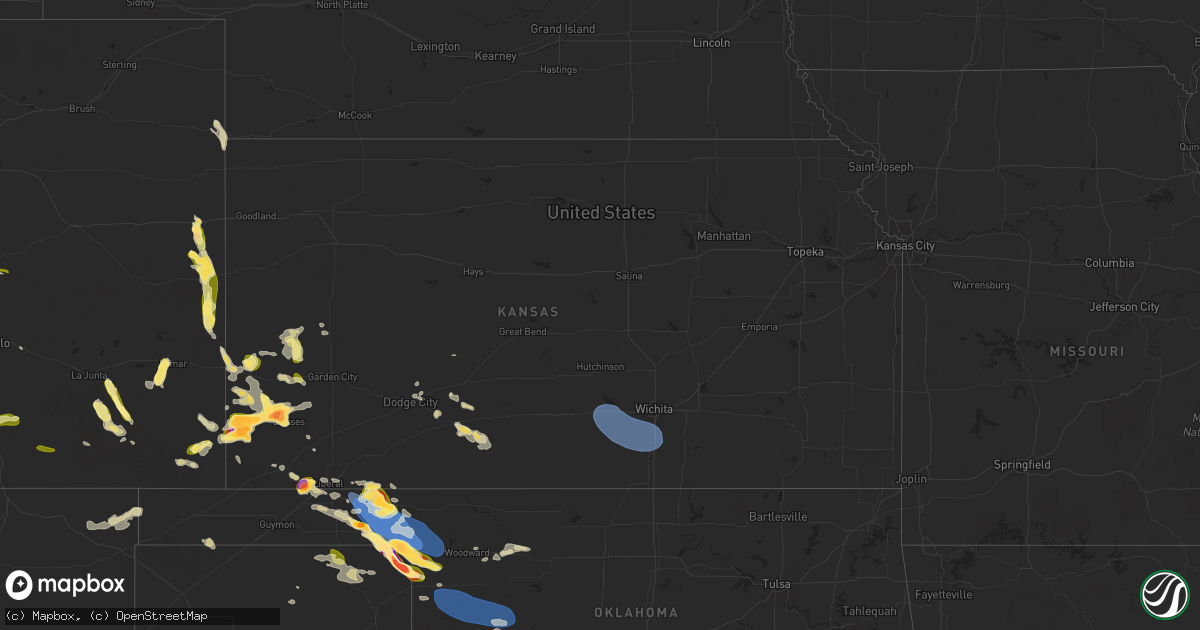
Hail Map in Kansas on May 28, 2025
Get this storm
May 28 map
$229
one time, instant access
Download today. No call, no setup
Keep the $229
Bought the map and want the full workflow? Apply the entire $229 to a subscription within 7 days. None of it is wasted.
Every map, not just this one
This buys you this map. Subscription and you get every map we run, in the markets you choose from a few cities to whole states to nationwide. Plus real-time alerts the moment a storm fires.
Contact data
Name, contact info, occupancy, even credit band for addresses in the footprint. You go from where it hit to who to call.
Become the source they trust
Unlimited branding weather history reports on demand. You already have the documented answer ready for the property owner, and you are the one who showed up with it.
Property data and RoofTrace estimates
Pull up any address you have got, its value and the exact code rules for that jurisdiction, straight from One Click Code. Then RoofTrace estimates the squares, pitch, and roof value, priced the way you price.
Storm reports in Kansas
Kansas
| Date | Description |
|---|---|
| 05/28/20256:33 PM CDT | A local report indicates 1.00 inch wind near Lakin |
| 05/28/20256:00 PM CDT | Report of 1 inch hail. |
| 05/28/20255:55 PM CDT | A local report indicates 1.00 inch wind near 10 SSW Woods |
| 05/28/20255:28 PM CDT | Storm chaser reports just above 2 inch hail via caliper via social media. |
| 05/28/20255:23 PM CDT | A local report indicates 2.00 inch wind near 11 SSW Woods |
| 05/28/20254:42 PM CDT | A local report indicates 2.00 inch wind near 2 N Manter |
| 05/28/20254:40 PM CDT | A local report indicates 1.25 inch wind near 10 NNW Ulysses |
| 05/28/20254:35 PM CDT | A local report indicates 2.00 inch wind near 2 E Manter |
| 05/28/20254:32 PM CDT | A local report indicates 2.00 inch wind near 7 NE Big Bow |
| 05/28/20254:28 PM CDT | A local report indicates 2.00 inch wind near Manter |
| 05/28/20254:25 PM CDT | A local report indicates 1.00 inch wind near Manter |
| 05/28/20254:20 PM CDT | Report received through social media with pictures. |
| 05/28/20254:08 PM CDT | Report was received through social media. |
| 05/27/20259:46 PM CDT | A local report indicates 62 MPH wind near 6 N Viola |
| 05/27/20257:00 PM CDT | Report was from social media. Nickel to quarter size hail in offerle. |
| 05/27/20257:00 PM CDT | Report w |
All States Impacted by Hail Map on May 28, 2025
Cities Impacted by Hail Map on May 28, 2025
- Smithville, TX
- Bastrop, TX
- League City, TX
- Port Isabel, TX
- Friendswood, TX
- Webster, TX
- West Palm Beach, FL
- Wellington, FL
- Loxahatchee, FL
- De Leon, TX
- Colorado Springs, CO
- Comanche, TX
- Peyton, CO
- Rochelle, TX
- Gustine, TX
- Mullin, TX
- Priddy, TX
- Brownwood, TX
- Richland Springs, TX
- Hamilton, TX
- Springfield, LA
- Livingston, LA
- Belle Rose, LA
- Napoleonville, LA
- Pierre Part, LA
- Bethune, CO
- Pottsville, TX
- Burlington, CO
- Grenville, NM
- San Saba, TX
- Wauchula, FL
- Fort Pierce, FL
- Goldthwaite, TX
- Myakka City, FL
- Kenton, OK
- Evant, TX
- Carriere, MS
- Picayune, MS
- Clayton, NM
- Baton Rouge, LA
- Pride, LA
- Zachary, LA
- Baker, LA
- Manter, KS
- Lometa, TX
- Purmela, TX
- Des Moines, NM
- Amite, LA
- Port Saint Lucie, FL
- Wray, CO
- Moran, TX
- Campo, CO
- Walsh, CO
- Greenwell Springs, LA
- Poplarville, MS
- Kingsland, GA
- Johnson, KS
- Model, CO
- Trinidad, CO
- Bend, TX
- Lampasas, TX
- Jonesboro, TX
- Gatesville, TX
- Kentwood, LA
- Roseland, LA
- Greensburg, LA
- Saint Marys, GA
- Kings Bay, GA
- Baird, TX
- Brooklyn, MS
- Indiantown, FL
- Haigler, NE
- Mount Hermon, LA
- Arapahoe, CO
- Cheyenne Wells, CO
- Ulysses, KS
- Burnet, TX
- Lumberton, MS
- Hattiesburg, MS
- Saint Francis, KS
- Coleman, TX
- Venus, FL
- Syracuse, KS
- Lake Placid, FL
- Purvis, MS
- Lakeland, FL
- Fort Hood, TX
- Tylertown, MS
- Jacksonville, FL
- Osyka, MS
- Leakesville, MS
- Richton, MS
- Franklinton, LA
- Forgan, OK
- Santa Anna, TX
- Jacksonville Beach, FL
- Bertram, TX
- Cisco, TX
- Cross Plains, TX
- Hooker, OK
- Hugoton, KS
- Lakin, KS
- Ponte Vedra Beach, FL
- Liberty Hill, TX
- Leander, TX
- Tibbie, AL
- Wagarville, AL
- Sumrall, MS
- Brookesmith, TX
- Leoti, KS
- Bangs, TX
- Meade, KS
- Deerfield, KS
- Sheridan Lake, CO
- Marble Falls, TX
- Satanta, KS
- Cedar Park, TX
- Austin, TX
- Gate, OK
- Scott City, KS
- Plains, KS
- Boone, CO
- Liberal, KS
- Burkett, TX
- Rolla, KS
- Coolidge, KS
- Palm Coast, FL
- Tyrone, OK
- Dalhart, TX
- Texhoma, OK
- Kismet, KS
- Castleberry, AL
- Evergreen, AL
- Fountain, CO
- Round Rock, TX
- Turpin, OK
- Bunnell, FL
- Del Valle, TX
- Kim, CO
- Holly, CO
- Lamar, CO
- Wiley, CO
- Hasty, CO
- Las Animas, CO
- Beaver, OK
- Offerle, KS
- Red Level, AL
- Andalusia, AL
- Alpine, TX
- Kendall, KS
- Florissant, CO
- Saint Stephens, AL
- Laverne, OK
- Deer Park, AL
- Cedar Creek, TX
- Manor, TX
- La Junta, CO
- Dale, TX
- Cherokee, TX
- Balko, OK
- Kinsley, KS
- Greensburg, KS
- Mullinville, KS
- Follett, TX
- Shattuck, OK
- Llano, TX
- Haviland, KS
- Ozark, AL
- Valley Spring, TX
- Bluffton, TX
- Tow, TX
- Buchanan Dam, TX
- Dodge City, KS
- Pritchett, CO
- Wright, KS
- Burdett, KS
- Booker, TX
- Darrouzett, TX
- Perryton, TX
- Kingsland, TX
- Stinnett, TX
- Ford, KS
- Canon City, CO
- Moscow, KS
- Horseshoe Bay, TX
- Elkhart, KS
- Penrose, CO
- Gulfport, MS
- Gage, OK
- Fargo, OK
- Higgins, TX
- Round Mountain, TX
- Spicewood, TX
- Johnson City, TX
- Dripping Springs, TX
- Biloxi, MS
- Woodward, OK
- Canadian, TX
- Wilmore, KS
- Arnett, OK
- Mooreland, OK
- Cheney, KS
- Kingman, KS
- Murdock, KS
- Goddard, KS
- Viola, KS
- Garden Plain, KS
- Clearwater, KS
- Milton, KS
- Norwich, KS
- Haysville, KS
- Conway Springs, KS
- Mayfield, KS
- Pretty Prairie, KS
- Silver Lake, OR
- Peck, KS
- Wellington, KS
- Derby, KS
- Mulvane, KS
- Belle Plaine, KS
- May, OK
- Spearman, TX
- Sharon, OK
- Vici, OK
- Leedey, OK
- Camargo, OK
- Taloga, OK
- Butler, OK
- Chester, OK
- Custer City, OK
- Putnam, OK
- Waynoka, OK
- Miami, TX
- Pampa, TX
- Arapaho, OK
- Wing, AL
- Weatherford, OK
- Florala, AL
- Sayre, OK
- Elk City, OK
- Clinton, OK
- Foss, OK
- Canute, OK
- Bessie, OK
- Corn, OK
- Cordell, OK
- Panama City Beach, FL
- Mangum, OK
- Santa Fe, TX
- Dickinson, TX
- Blair, OK
- Lone Wolf, OK
- Granite, OK


