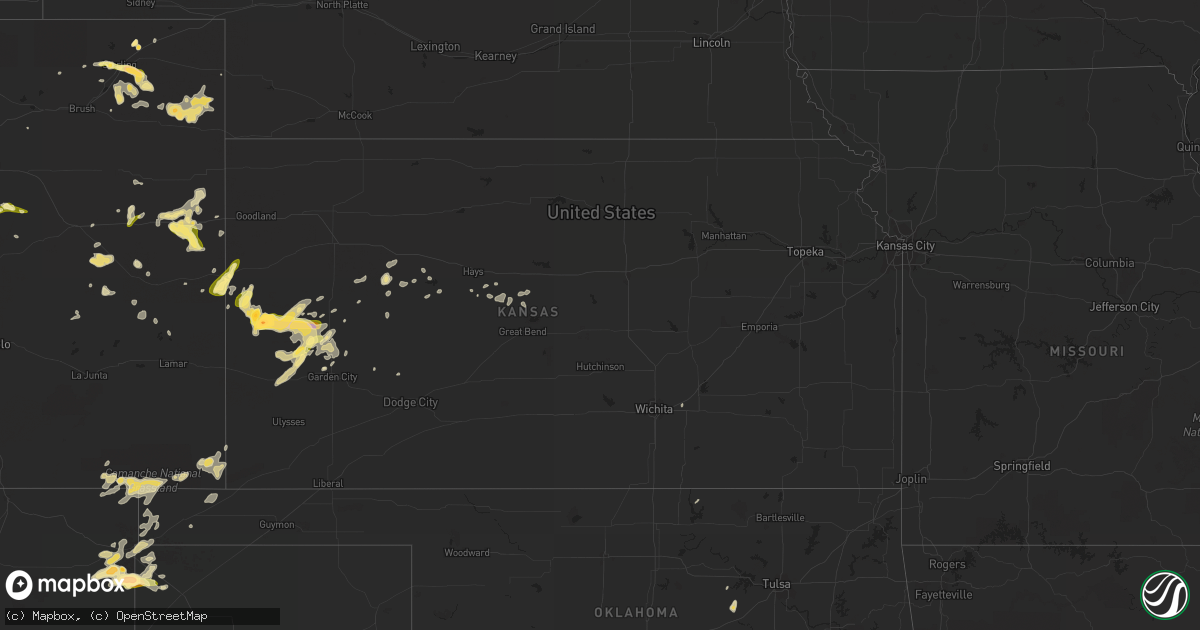
Hail Map in Kansas on May 28, 2015
Get this storm
May 28 map
$229
one time, instant access
Download today. No call, no setup
Keep the $229
Bought the map and want the full workflow? Apply the entire $229 to a subscription within 7 days. None of it is wasted.
Every map, not just this one
This buys you this map. Subscription and you get every map we run, in the markets you choose from a few cities to whole states to nationwide. Plus real-time alerts the moment a storm fires.
Contact data
Name, contact info, occupancy, even credit band for addresses in the footprint. You go from where it hit to who to call.
Become the source they trust
Unlimited branding weather history reports on demand. You already have the documented answer ready for the property owner, and you are the one who showed up with it.
Property data and RoofTrace estimates
Pull up any address you have got, its value and the exact code rules for that jurisdiction, straight from One Click Code. Then RoofTrace estimates the squares, pitch, and roof value, priced the way you price.
Storm reports in Kansas
Kansas
| Date | Description |
|---|---|
| 05/28/20156:35 PM CDT | A local report indicates 60 MPH wind near NESS CITY |
| 05/28/20156:35 PM CDT | A local report indicates 60 MPH wind near 3 NW BROWNELL |
| 05/28/20156:15 PM CDT | A local report indicates 66 MPH wind near 10 SE BEELER |
| 05/28/20156:11 PM CDT | A local report indicates 60 MPH wind near 3 WNW UTICA |
| 05/28/20155:52 PM CDT | A local report indicates 65 MPH wind near 3 N DIGHTON |
| 05/28/20155:48 PM CDT | A local report indicates 1.00 inch wind near 14 N DEERFIELD |
| 05/28/20155:30 PM CDT | Transformer fire along highway 4 at the scott lane county line |
| 05/28/20155:26 PM CDT | Also had nickel sized hail. |
| 05/28/20155:21 PM CDT | A local report indicates 59 MPH wind near 5 SSW GRIGSTON |
| 05/28/20155:20 PM CDT | Measured wind gust report relayed by the lane county dispatch. |
| 05/28/20155:14 PM CDT | Very brief tornado looking west from highway 83 at the county line |
| 05/28/20155:10 PM CDT | A local report indicates 1.00 inch wind near 10 S MODOC |
| 05/28/20154:58 PM CDT | A local report indicates 1.00 inch wind near 17 NNW DEERFIELD |
| 05/28/20154:54 PM CDT | Storm chaser reported a likely tornado wrapped in rain looking west. |
| 05/28/20154:42 PM CDT | A local report indicates 1.25 inch wind near 13 NNW DEERFIELD |
| 05/28/20154:07 PM CDT | Relayed via spotter network... Brief touchdown... Lifted within a minute |
| 05/28/20154:05 PM CDT | A local report indicates 1.00 inch wind near LEOTI |
| 05/28/20153:55 PM CDT | Relayed via spotter network |
| 05/28/20153:55 PM CDT | Relayed via spotter network |
| 05/28/20153:54 PM CDT | Relayed via spotter network |
| 05/28/20153:37 PM CDT | Relayed via spotter network |
| 05/28/20153:35 PM CDT | Relayed via spotter network. |
| 05/28/20153:31 PM CDT | Relayed via spotter network. |
| 05/28/20153:14 PM CDT | Moving north |
| 05/28/20152:41 PM CDT | A local report indicates 1.25 inch wind near TRIBUNE |
| 05/28/20152:37 PM CDT | A local report indicates 1.00 inch wind near TRIBUNE |
All States Impacted by Hail Map on May 28, 2015
Cities Impacted by Hail Map on May 28, 2015
- Scott City, KS
- Burkett, TX
- Albany, TX
- Gainesville, TX
- Roscoe, SD
- Throckmorton, TX
- Martin, SD
- Eldon, MO
- Slaton, TX
- Lubbock, TX
- Ransom Canyon, TX
- Hyannis, NE
- Whitman, NE
- Farmersville, TX
- Breckenridge, TX
- Hecla, SD
- Karval, CO
- Fort Davis, TX
- Balmorhea, TX
- Sonora, TX
- Matador, TX
- Floydada, TX
- Lockney, TX
- Wray, CO
- Minto, ND
- Sugar City, CO
- Ordway, CO
- Early, TX
- Quinter, KS
- Bridgeport, NE
- Bayard, NE
- Quinnesec, MI
- Niagara, WI
- Vulcan, MI
- Norway, MI
- Roosevelt, MN
- Fort Stockton, TX
- West Newfield, ME
- Iliff, CO
- Old Glory, TX
- Seymour, TX
- Paducah, TX
- Marathon, TX
- Eagle Butte, SD
- Clayton, DE
- Dover, DE
- Wanblee, SD
- Burlington, CO
- Crosbyton, TX
- Dickens, TX
- Windthorst, TX
- Dryden, TX
- Ackerly, TX
- Lamesa, TX
- Lorenzo, TX
- Stapleton, NE
- Honeyville, UT
- Brigham City, UT
- Bear River City, UT
- Crookston, MN
- Red Lake Falls, MN
- Kyle, SD
- Haskell, TX
- Eckley, CO
- Holyoke, CO
- Yuma, CO
- Wichita Falls, TX
- Melvin, TX
- Crane, TX
- Princeton, TX
- Blue Ridge, TX
- Plainview, TX
- Winters, TX
- Westbrook, ME
- Windham, ME
- Valentine, NE
- Mason, TX
- Dallas, TX
- Idalou, TX
- Smyer, TX
- Ropesville, TX
- Levelland, TX
- Tatum, NM
- Littlefield, TX
- Plains, TX
- Morton, TX
- Wolfforth, TX
- Shallowater, TX
- Anton, TX
- Whiteface, TX
- Meadow, TX
- Abernathy, TX
- New Deal, TX
- Lohn, TX
- Sheldon, ND
- Leonard, ND
- Prescott, AR
- Elsie, NE
- Brady, TX
- Brookesmith, TX
- Saline, LA
- Menard, TX
- Gregory, SD
- Brownwood, TX
- Cross Plains, TX
- Muenster, TX
- Saint Jo, TX
- Iraan, TX
- Newcastle, TX
- Lakin, KS
- Holcomb, KS
- Sharon Springs, KS
- Marienthal, KS
- Leoti, KS
- Tribune, KS
- Deerfield, KS
- Avoca, TX
- Stamford, TX
- Leola, SD
- Ellsworth, ME
- Holden, ME
- Orrington, ME
- Bucksport, ME
- Brewer, ME
- Eddington, ME
- Iron Mountain, MI
- Jennings, OK
- Crowell, TX
- Rocksprings, TX
- Thief River Falls, MN
- Rush Springs, OK
- Marlow, OK
- Weskan, KS
- Arapahoe, CO
- Gail, TX
- Cogswell, ND
- Forman, ND
- Lewellen, NE
- Sedan, NM
- Texline, TX
- Carrollton, MO
- Edgeley, ND
- Akron, CO
- Lawton, OK
- Sterling, CO
- Forestburg, TX
- Wakeeney, KS
- Caddo, TX
- Imperial, TX
- Beulah, ND
- Halliday, ND
- Perrin, TX
- Walters, OK
- Duncan, OK
- Holabird, SD
- Wounded Knee, SD
- Batesland, SD
- Allen, SD
- Dublin, TX
- Alex, OK
- Blanchard, OK
- Henrietta, TX
- Electra, TX
- Vernon, TX
- Junction, TX
- London, TX
- Davenport, ND
- Loving, TX
- Jacksboro, TX
- Jermyn, TX
- Olney, TX
- Sutherland, NE
- Paxton, NE
- Wilton, CT
- Ridgefield, CT
- South Salem, NY
- North Salem, NY
- Pound Ridge, NY
- Girard, TX
- Spur, TX
- Aurora, CO
- Georgetown, LA
- Bentley, LA
- Dry Prong, LA
- Rotan, TX
- Aspermont, TX
- Castor, LA
- Bryson, TX
- Fullerton, ND
- Waxahachie, TX
- Benton, LA
- Holliday, TX
- Gove, KS
- Madrid, NE
- Blanket, TX
- Eldorado, TX
- Hoisington, KS
- Lavon, TX
- Euclid, MN
- Wilson, TX
- Sundown, TX
- Amherst, MA
- Comanche, OK
- Clyde, TX
- Powhatan, VA
- Argyle, MN
- Grafton, ND
- Stephen, MN
- Bayville, NJ
- Seaside Park, NJ
- Pecos, TX
- Tolstoy, SD
- Onaka, SD
- Grassy Butte, ND
- Walsh, CO
- Campo, CO
- Graham, TX
- Denver, CO
- Paint Rock, TX
- Rowena, TX
- Otis, CO
- Fleming, CO
- Whitesboro, TX
- Warroad, MN
- Spearsville, LA
- Dodge, ND
- Nevada, TX
- Ninnekah, OK
- Temple, OK
- San Angelo, TX
- Fort Sill, OK
- Zap, ND
- Hugo, CO
- Timber Lake, SD
- Hastings, OK
- Randlett, OK
- Byers, TX
- Ryan, OK
- Waurika, OK
- Boelus, NE
- Dannebrog, NE
- Sugar Valley, GA
- Calhoun, GA
- Garden City, KS
- Miles, TX
- Ballinger, TX
- Tishomingo, OK
- Mill Creek, OK
- Odonnell, TX
- McCaskill, AR
- Resaca, GA
- Dalton, GA
- Merriman, NE
- Portales, NM
- Belchertown, MA
- Monument, CO
- Frederick, SD
- Clovis, NM
- Rochelle, TX
- Richland Springs, TX
- Marietta, OK
- Burneyville, OK
- Cartersville, VA
- Cumberland, VA
- Jal, NM
- Wolfe City, TX
- Okolona, AR
- Elida, NM
- Kennedy, MN
- Garden City, TX
- Navasota, TX
- Arthur, NE
- Springview, NE
- Bristow, OK
- Loveland, OK
- Ellendale, ND
- Grenville, NM
- Kenton, OK
- Pritchett, CO
- Jayton, TX
- Snyder, TX
- Smyrna, DE
- Winnfield, LA
- Standish, ME
- Raymond, ME
- Gray, ME
- Dighton, KS
- Clayton, NM
- Dalhart, TX
- Alma, MO
- Corder, MO
- Graford, TX
- San Diego, TX
- Smithfield, ME
- Fairfield, ME
- Clinton, ME
- Porcupine, SD
- Madill, OK
- Schoenchen, KS
- Hays, KS
- Baird, TX
- Loco, OK
- Ringling, OK
- Stratton, CO
- Cisco, TX
- Mertzon, TX
- Canaan, ME
- Pittsfield, ME
- Milnesand, NM
- Nashville, AR
- Gustine, TX
- Carlton, TX
- Isabel, SD
- Berlin, ND
- Dickey, ND
- Lamoure, ND
- Marion, ND
- Bethune, CO
- Dierks, AR
- Lockesburg, AR
- De Queen, AR
- Saint Hilaire, MN
- Barnhart, TX
- Oshkosh, NE
- Karlstad, MN
- Freer, TX
- Tahoka, TX
- Brownfield, TX
- Beltrami, MN
- Merino, CO
- Kiowa, CO
- Mead, OK
- Kingston, OK
- Ransom, KS
- Brownell, KS
- Merna, NE
- Higginsville, MO
- Warrensburg, MO
- Concordia, MO
- Gordonville, TX
- Riceville, TN
- Eads, CO
- Poolville, TX
- Weatherford, TX
- Stephens, AR
- Magnolia, AR
- Sheffield, TX
- Coushatta, LA
- Hall Summit, LA
- Ringgold, LA
- Mcadoo, TX
- Forbes, ND
- Sweetwater, TX
- Mckinney, TX
- Geronimo, OK
- Faxon, OK
- Ozona, TX
- North Platte, NE
- Champion, NE
- Fredericksburg, TX
- Sidney, NE
- Big Spring, TX
- Winner, SD
- Broomfield, CO
- Russell, KS
- Hamlin, TX
- Nocona, TX
- Bowie, TX
- Roby, TX
- San Saba, TX
- Cope, CO
- Maryneal, TX
- Roscoe, TX
- Ardmore, OK
- Lewisville, AR
- Tullos, LA
- Broadwater, NE
- Millersview, TX
- Redfield, SD
- Oakes, ND
- Red Cloud, NE
- Kit Carson, CO
- Spokane, WA
- Logan, NM
- Johnstown, NE
- Rosston, AR
- Goldonna, LA
- Boise City, OK
- Mountain Home, TX
- Ingram, TX
- Danbury, CT
- Grant, NE
- Imperial, NE
- Crook, CO
- Reliance, SD
- Blackwell, TX
- Felt, OK
- Fluvanna, TX
- Christoval, TX
- Gatzke, MN
- Munday, TX
- Coyanosa, TX
- Eden, TX
- Eclectic, AL
- Atlanta, LA
- Lisbon, ND
- Garwood, TX
- Vona, CO
- Idalia, CO
- Nara Visa, NM
- Upper Marlboro, MD
- Moran, TX
- Cement, OK
- Fletcher, OK
- Caddo Gap, AR
- Norman, AR
- Eola, TX
- Wheatland, ND
- Uvalde, TX
- Rule, TX
- Inman, NE
- Cyril, OK
- Knott, TX
- Alpharetta, GA
- Cumming, GA
- Holden, MO
- Centerview, MO
- Casper, WY
- Woodson, TX
- Thedford, NE
- Valley City, ND
- Elgin, OK
- Oacoma, SD
- Mentor, MN
- Garland City, AR
- Lueders, TX
- Donaldson, MN
- Corydon, IA
- Pine Ridge, SD
- Cimarron, KS
- Mullin, TX
- Comanche, TX
- Milnor, ND
- Mcleod, ND
- Wyndmere, ND
- Hodgen, OK
- Chamberlain, SD
- Pine Beach, NJ
- Island Heights, NJ
- Toms River, NJ
- Kim, CO
- Axtell, TX
- Mount Calm, TX
- Bronte, TX
- Bangs, TX
- Jamestown, ND
- Ypsilanti, ND
- Spiritwood, ND
- Egg Harbor City, NJ
- Elm Grove, LA
- Miller, SD
- Salt Flat, TX
- Minden, LA
- Stoneham, CO
- Terral, OK
- Vancourt, TX
- Petersham, MA
- Athol, MA
- Norridgewock, ME
- Washington, AR
- Fulton, AR
- Hope, AR
- Oslo, MN
- Mannsville, OK
- Gettysburg, SD
- Harper, TX
- Franklin, ID
- Ainsworth, NE
- Sharon, ND
- Strong, AR
- Elizabeth, CO
- Knox City, TX
- Junction City, AR
- Jud, ND
- Healdton, OK
- Wilson, OK
- Victoria, KS
- Bellevue, TX
- Concepcion, TX
- Hosmer, SD
- Stanton, TX
- Bowdle, SD
- Sargent, NE
- Harrold, TX
- Otis, KS
- Bison, KS
- Cartwright, OK
- Durant, OK
- Calera, OK
- Vernon, VT
- Hinsdale, NH
- Winchester, NH
- Brattleboro, VT
- Oklee, MN
- Gorham, ME
- Scarborough, ME
- Alvord, TX
- Sunset, TX
- Culbertson, NE
- Brandywine, MD
- Tuscumbia, MO
- Ewing, NE
- Orchard, NE
- Royal, NE
- Somerville, TX
- Preston, ID
- Hamill, SD
- Tuscola, TX
- New Braunfels, TX
- San Marcos, TX
- Midland, TX
- Comstock, TX
- Voss, TX
- Strawn, TX
- Calhan, CO
- Ramah, CO
- Ashuelot, NH
- West Halifax, VT
- Flagler, CO
- Trail City, SD
- Rockwood, TX
- Lindsay, TX
- Valley View, TX
- Hayes Center, NE
- Oneill, NE
- Abilene, TX
- Anna, TX
- Buxton, ME
- Mahopac, NY
- Campti, LA
- Natchitoches, LA
- Belcher, LA
- Chillicothe, TX
- Newkirk, OK
- Zephyr, TX
- Waccabuc, NY
- Archer City, TX
- Keyes, OK
- Mannford, OK
- Indiahoma, OK
- Cache, OK
- Bluff City, AR
- Ralls, TX
- Colome, SD
- Arriba, CO
- Healy, KS
- Brainard, NY
- Nassau, NY
- Defuniak Springs, FL
- Grandin, ND
- Gardner, ND
- Dunning, NE
- Utica, KS
- Cross River, NY
- Carmel, NY
- New Fairfield, CT
- Bethel, CT
- Brewster, NY
- Putnam Valley, NY
- Rogers, ND
- Northfield, MA
- Jacksonville, VT
- Ozan, AR
- Santa Anna, TX
- Rochester, TX
- Rushville, NE
- McNeil, AR
- Rockwall, TX
- La Crosse, KS
- Ellis, KS
- Hamilton, TX
- Montague, TX
- Chico, TX
- Templeton, MA
- Arnold, NE
- Goodridge, MN
- Grygla, MN
- Halsey, NE
- Andrews, TX
- Ipswich, SD
- Oklaunion, TX
- Hoven, SD
- Hershey, NE
- Ashland, AL
- Millerville, AL
- Goodwater, AL
- Leakey, TX
- Benjamin, TX
- Wood, SD
- Royse City, TX
- Cherokee, TX
- Cotton Valley, LA
- Oriska, ND
- New Salem, ND
- Purdys, NY
- Croton Falls, NY
- Trumbull, CT
- Redding, CT
- Somers, NY
- Easton, CT
- Hico, TX
- Iredell, TX
- Ranger, TX
- Hyrum, UT
- Wellsville, UT
- Wylie, TX
- Kindred, ND
- Middletown, MO
- Celeste, TX
- Greenville, TX
- Iowa Park, TX
- Beachwood, NJ
- Ocean Gate, NJ
- Blevins, AR
- Kopperl, TX
- Cache Junction, UT
- Collinston, UT
- Roosevelt, TX
- Adairsville, GA
- Del Rio, TX
- Murdo, SD
- Olmitz, KS
- Naper, NE
- Beulah, CO
- Emmet, AR
- Monahans, TX
- Fort Pierre, SD
- Atoka, OK
- Cheyenne Wells, CO
- Ringgold, TX
- Voca, TX
- Genoa, CO
- Perkinston, MS
- New Salem, MA
- Hubbardston, MA
- Barre, MA
- Orange, MA
- Goochland, VA
- Murfreesboro, AR
- Delight, AR
- Bridgeport, TX
- Post, TX
- Ashland, LA
- Finley, ND
- Mills, NE
- Long Lake, SD
- Roggen, CO
- Mesquite, TX
- Colorado City, CO
- Mineral Wells, TX
- Elberton, GA
- New Raymer, CO
- Ashby, NE
- Sanborn, ND
- Page, NE
- Augusta, KS
- Seminole, TX
- Sibley, LA
- Rio Vista, TX
- Blum, TX
- Cleburne, TX
- Saucier, MS
- Fingal, ND
- Fulton, MO
- Gilliam, LA
- Eastland, TX
- Jetmore, KS
- Rising Star, TX
- Mapleton, ND
- West Fargo, ND
- Doole, TX
- Rutland, ND
- West Chesterfield, NH
- Spofford, NH
- Chesterfield, NH
- Swanzey, NH
- Thackerville, OK
- Causey, NM
- Chambers, NE
- Chidester, AR
- Coleman, OK
- Plummer, MN
- Gatesville, TX
- Bennett, CO
- Deweyville, UT
- Cannon Afb, NM


