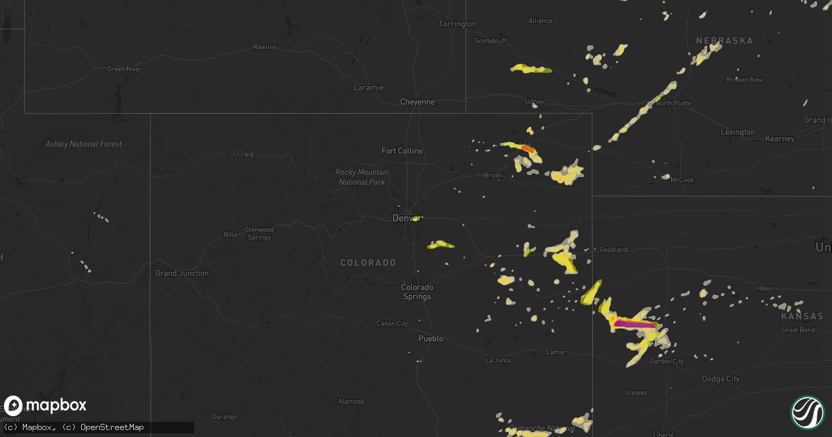
Hail Map on May 28, 2015
Get this storm
May 28 map
$229
one time, instant access
Download today. No call, no setup
Keep the $229
Bought the map and want the full workflow? Apply the entire $229 to a subscription within 7 days. None of it is wasted.
Every map, not just this one
This buys you this map. Subscription and you get every map we run, in the markets you choose from a few cities to whole states to nationwide. Plus real-time alerts the moment a storm fires.
Contact data
Name, contact info, occupancy, even credit band for addresses in the footprint. You go from where it hit to who to call.
Become the source they trust
Unlimited branding weather history reports on demand. You already have the documented answer ready for the property owner, and you are the one who showed up with it.
Property data and RoofTrace estimates
Pull up any address you have got, its value and the exact code rules for that jurisdiction, straight from One Click Code. Then RoofTrace estimates the squares, pitch, and roof value, priced the way you price.
States Impacted by Hail Map on May 28, 2015
Storm reports
Kansas
| Date | Description |
|---|---|
| 05/28/20156:35 PM CDT | A local report indicates 60 MPH wind near 3 NW BROWNELL |
| 05/28/20156:35 PM CDT | A local report indicates 60 MPH wind near NESS CITY |
| 05/28/20156:15 PM CDT | A local report indicates 66 MPH wind near 10 SE BEELER |
| 05/28/20156:11 PM CDT | A local report indicates 60 MPH wind near 3 WNW UTICA |
| 05/28/20155:52 PM CDT | A local report indicates 65 MPH wind near 3 N DIGHTON |
| 05/28/20155:48 PM CDT | A local report indicates 1.00 inch wind near 14 N DEERFIELD |
| 05/28/20155:30 PM CDT | Transformer fire along highway 4 at the scott lane county line |
| 05/28/20155:26 PM CDT | Also had nickel sized hail. |
| 05/28/20155:21 PM CDT | A local report indicates 59 MPH wind near 5 SSW GRIGSTON |
| 05/28/20155:20 PM CDT | Measured wind gust report relayed by the lane county dispatch. |
| 05/28/20155:14 PM CDT | Very brief tornado looking west from highway 83 at the county line |
| 05/28/20155:10 PM CDT | A local report indicates 1.00 inch wind near 10 S MODOC |
| 05/28/20154:58 PM CDT | A local report indicates 1.00 inch wind near 17 NNW DEERFIELD |
| 05/28/20154:54 PM CDT | Storm chaser reported a likely tornado wrapped in rain looking west. |
| 05/28/20154:42 PM CDT | A local report indicates 1.25 inch wind near 13 NNW DEERFIELD |
| 05/28/20154:07 PM CDT | Relayed via spotter network... Brief touchdown... Lifted within a minute |
| 05/28/20154:05 PM CDT | A local report indicates 1.00 inch wind near LEOTI |
| 05/28/20153:55 PM CDT | Relayed via spotter network |
| 05/28/20153:55 PM CDT | Relayed via spotter network |
| 05/28/20153:54 PM CDT | Relayed via spotter network |
| 05/28/20153:37 PM CDT | Relayed via spotter network |
| 05/28/20153:35 PM CDT | Relayed via spotter network. |
| 05/28/20153:31 PM CDT | Relayed via spotter network. |
| 05/28/20153:14 PM CDT | Moving north |
| 05/28/20152:41 PM CDT | A local report indicates 1.25 inch wind near TRIBUNE |
| 05/28/20152:37 PM CDT | A local report indicates 1.00 inch wind near TRIBUNE |
South Dakota
| Date | Description |
|---|---|
| 05/28/20155:10 PM CDT | Many quarter sized hail stones |
| 05/27/20157:25 PM CDT | Brief burst of wind along with pea size hail for about 2 minutes |
Massachusetts
| Date | Description |
|---|---|
| 05/28/20155:10 PM CDT | Tree down on vincent rd. Tree down on house on casco rd. |
| 05/28/20155:10 PM CDT | 4 inch diameter tree limb down on salem street |
| 05/28/20155:01 PM CDT | Large limb down on mbta tracks near greenwood station. |
| 05/28/20154:50 PM CDT | Tree down on wires on manhattan drive. |
| 05/28/20154:22 PM CDT | 4 telephone poles and trees and wires blown down on nabbys point road as confirmed by ema director. Large limb down on broadway avenue. Tree down on mbta tracks at newb |
| 05/28/20154:15 PM CDT | Numerous trees and wires down across roads |
| 05/28/20154:14 PM CDT | Trees and wires down on pingree farm road |
| 05/28/20154:10 PM CDT | Approx twenty to thirty trees are down as well as wires on hampstead and old homestead streets. This damage is due from a microburst that produced approx 70 mph in stre |
| 05/28/20154:10 PM CDT | A local report indicates 70 MPH wind near METHUEN |
| 05/28/20153:50 PM CDT | Large tree down on ware brook drive. |
| 05/28/20153:05 PM CDT | Tree down on snell street blocking one lane |
| 05/28/20152:26 PM CDT | Trees and wires down |
| 05/28/20152:00 PM CDT | Trees and wires down on shelburne falls road |
New Mexico
| Date | Description |
|---|---|
| 05/28/20156:28 PM CDT | A local report indicates 1.00 inch wind near SEDAN |
| 05/28/20156:05 PM CDT | A local report indicates 1.75 inch wind near 1 N SEDAN |
| 05/28/20155:55 PM CDT | Hen egg size hail from 455 to 505pm. |
| 05/28/20155:42 PM CDT | A local report indicates 1.00 inch wind near 4 S CANNON AFB |
| 05/28/20155:32 PM CDT | Kcvs asos. Mostly 0.50 inch...but a number of 1.00 inch stones measured by cannon afb weather |
| 05/28/20154:40 PM CDT | A local report indicates 1.75 inch wind near 11 NNW SEDAN |
| 05/27/20157:34 PM CDT | A local report indicates 1.75 inch wind near PORTALES |
| 05/27/20157:33 PM CDT | A local report indicates 1.75 inch wind near 2 SW PORTALES |
| 05/27/20157:32 PM CDT | A local report indicates 1.50 inch wind near PORTALES |
| 05/27/20157:22 PM CDT | A local report indicates 1.50 inch wind near 2 SW PORTALES |
| 05/27/20157:05 PM CDT | A local report indicates 1.00 inch wind near 3 NE PORTALES |
Colorado
| Date | Description |
|---|---|
| 05/28/20155:00 PM CDT | Mostly marble size hail... Some quarter mixed in. |
| 05/28/20154:55 PM CDT | A local report indicates a tornado near 15 S VILAS |
| 05/28/20154:44 PM CDT | Tornado on ground for 5 minutes... Heading due east |
| 05/28/20154:34 PM CDT | A local report indicates 1.00 inch wind near 5 S STRATTON |
| 05/28/20154:21 PM CDT | A local report indicates 1.00 inch wind near 12 SW WESKAN |
| 05/28/20154:17 PM CDT | Quarter and dime size hail... On hwy 40... Mile marker 486 |
| 05/28/20154:15 PM CDT | A local report indicates 1.25 inch wind near 15 SE STERLING |
| 05/28/20153:41 PM CDT | A local report indicates a tornado near 6 S KIM |
| 05/28/20153:24 PM CDT | Quarter size hail mixing with penny. |
| 05/28/20153:18 PM CDT | A local report indicates 1.00 inch wind near 1 N ELIZABETH |
| 05/28/20153:05 PM CDT | A local report indicates 1.50 inch wind near NNW ILIFF |
| 05/27/20158:53 PM CDT | A local report indicates 1.00 inch wind near 6 E DENVER |
| 05/27/20158:37 PM CDT | A local report indicates 1.00 inch wind near 3 NW AURORA |
Minnesota
| Date | Description |
|---|---|
| 05/28/20156:30 PM CDT | Social media photo of 2 inch spiked hail |
| 05/28/20156:09 PM CDT | Estimated winds along with drifts of pea sized hail. |
| 05/28/20155:25 PM CDT | Hail was accompanied by very heavy rains and damaging winds. Several large branches and tree limbs were broken down in a farmyard. |
| 05/28/20154:03 PM CDT | A local report indicates 1.00 inch wind near 4 S RED LAKE FALLS |
| 05/28/20153:52 PM CDT | Via social media post. |
Michigan
| Date | Description |
|---|---|
| 05/28/20156:15 PM CDT | Report via social media. Quarter sized hail reported between norway and vulcan. Delayed report. |
| 05/28/20154:15 PM CDT | Delayed report |
| 05/27/20157:34 PM CDT | Estimated 2.0 inch hail reported in norway. Report via social media. |
| 05/27/20157:25 PM CDT | Co-op observer reports quarter sized hail in norway. |
Georgia
| Date | Description |
|---|---|
| 05/28/20154:36 PM CDT | A tree down across mary elizabeth drive |
| 05/28/20154:32 PM CDT | Tree down along south dixie highway and rabbit way |
| 05/28/20154:05 PM CDT | Mostly dime to nickle size hail but few up to quarter size. |
New York
| Date | Description |
|---|---|
| 05/28/20154:31 PM CDT | Downed tree on smith ridge road. |
| 05/28/20154:31 PM CDT | Downed tree on smith ridge road. |
| 05/28/20154:26 PM CDT | Downed tree on smith ridge road. |
| 05/28/20154:26 PM CDT | Downed tree on spring street. |
New Hampshire
| Date | Description |
|---|---|
| 05/28/20153:55 PM CDT | Trees down williams and shepard ave... Wires down lawrence rd. |
| 05/28/20153:50 PM CDT | Multiple trees down |
| 05/28/20153:15 PM CDT | Large branches and power lines down |
| 05/28/20153:05 PM CDT | Large branches and power lines down |
| 05/28/20153:00 PM CDT | Treess and power lines down |
| 05/28/20152:32 PM CDT | Trees and wires down on fitzgerald drive |
| 05/28/20152:23 PM CDT | Trees and wires down on martin cook road |
| 05/28/20152:00 PM CDT | Trees down on headlands road on forest lake |
| 05/28/20152:00 PM CDT | Tree and wires down on a car on rabbit hollow road in winchester |
| 05/28/20151:00 PM CDT | A local report indicates 58 MPH wind near PORTSMOUTH INTL AIRPORT |
Connecticut
| Date | Description |
|---|---|
| 05/28/20153:46 PM CDT | Numerous trees downed |
| 05/28/20152:41 PM CDT | Quarter size hail reported via ping project |
| 05/28/20152:30 PM CDT | Tree down on great plain road. |
Arkansas
| Date | Description |
|---|---|
| 05/28/20152:40 PM CDT | A tornado damaged barns and blew down trees. It was witnessed by residents of the area. |
| 05/28/20152:20 PM CDT | Large trees uprooted north of highfill. Emergency manager also reports other damage in the county. |
| 05/28/20152:09 PM CDT | A tornado uprooted trees...damaged barns and outbuildings...and damaged a chicken house. |
Oklahoma
| Date | Description |
|---|---|
| 05/28/20156:36 PM CDT | A local report indicates 1.50 inch wind near 11 W MARLOW |
| 05/28/20156:35 PM CDT | A local report indicates 58 MPH wind near 3 W GRANDFIELD |
| 05/28/20156:30 PM CDT | Spotter reports shingle damage and several trees down. |
| 05/28/20154:15 PM CDT | Reported via nssl shave |
| 05/28/20154:12 PM CDT | Reported via nssl shave |
| 05/28/20153:52 PM CDT | Reported via nssl shave |
| 05/28/20153:50 PM CDT | Reported via nssl shave |
| 05/28/20153:39 PM CDT | A local report indicates 1.50 inch wind near 4 E LAWTON |
| 05/28/20153:12 PM CDT | A local report indicates 1.75 inch wind near RUSH SPRINGS |
| 05/28/20153:12 PM CDT | A local report indicates 1.00 inch wind near 5 S LAWTON |
| 05/28/201510:00 AM CDT | Considerable damage occurring to a home from line of thunderstorms. |
| 05/28/20159:58 AM CDT | A tornado blew large portions of the roof from a home and snapped trees. |
| 05/27/20159:05 PM CDT | A local report indicates 67 MPH wind near 3 SW MARIETTA |
| 05/27/20158:30 PM CDT | Trees snapped or uprooted. |
| 05/27/20158:01 PM CDT | Substantial tree damage. |
| 05/27/20157:31 PM CDT | A local report indicates 72 MPH wind near 7 SW COMANCHE |
| 05/27/20157:29 PM CDT | Damage to roof at truck stop at highways 70 and 81. Winds estimated 60-70 mph. |
Utah
| Date | Description |
|---|---|
| 05/28/20154:30 PM CDT | A local report indicates 61 MPH wind near 1 E CRESCENT JUNCTION |
| 05/28/20153:40 PM CDT | Ping pong size hail observed and photographed in honeyville. Time estimated. |
Texas
| Date | Description |
|---|---|
| 05/28/20156:35 PM CDT | Power lines down at holiday and jacksboro. |
| 05/28/20156:30 PM CDT | A local report indicates 1.25 inch wind near FARMERSVILLE |
| 05/28/20156:26 PM CDT | A local report indicates 1.75 inch wind near FARMERSVILLE |
| 05/28/20156:21 PM CDT | Public reports several tree limbs snapped and several trees uprooted. |
| 05/28/20156:21 PM CDT | Quarter size hail in farmersville |
| 05/28/20156:18 PM CDT | A local report indicates 59 MPH wind near 3 NW BURKBURNETT |
| 05/28/20156:07 PM CDT | Ham radio spotter reports tree limbs snapped and one tree down on car in haynesville... Estimated winds around 80 mph via anemometer. |
| 05/28/20156:00 PM CDT | Power poles snapped |
| 05/28/20155:53 PM CDT | A local report indicates 60 MPH wind near HAYNESVILLE |
| 05/28/20155:45 PM CDT | Measured near county line road and hwy 287 |
| 05/28/20155:40 PM CDT | On county road 209 |
| 05/28/20155:14 PM CDT | A local report indicates 60 MPH wind near STAMFORD |
| 05/28/20154:50 PM CDT | A local report indicates 70 MPH wind near SEYMOUR |
| 05/28/20154:30 PM CDT | Hail lasted for 15 minutes between 430 and 445 pm |
| 05/28/20154:12 PM CDT | Time estimated from radar. |
| 05/28/20153:56 PM CDT | A local report indicates 1.50 inch wind near 1 SE CROWELL |
| 05/28/20153:55 PM CDT | Tree limbs down. |
| 05/28/20153:50 PM CDT | A local report indicates 1.00 inch wind near 25 WNW FORT STOCKTON |
| 05/28/20153:45 PM CDT | A local report indicates 1.00 inch wind near 17 NW GAIL |
| 05/28/20153:37 PM CDT | Spotter reported brief tornado. |
| 05/28/20153:13 PM CDT | A local report indicates 80 MPH wind near 6 W CROWELL |
| 05/28/20153:10 PM CDT | A local report indicates 2.00 inch wind near 3 N GUTHRIE |
| 05/28/20153:10 PM CDT | A local report indicates a tornado near 21 NW GAIL |
| 05/28/20152:50 PM CDT | A local report indicates 1.00 inch wind near 10 W TAHOKA |
| 05/28/20152:10 PM CDT | West texas mesonet |
| 05/28/20152:00 PM CDT | A local report indicates 1.00 inch wind near 5 W VERNON |
| 05/28/20151:53 PM CDT | Metar observation. |
| 05/28/20151:45 PM CDT | A local report indicates 1.50 inch wind near 2 S LUBBOCK INTL AIRPOR |
| 05/28/20151:40 PM CDT | Power pole downed near 4th and quaker ave. |
| 05/28/20151:32 PM CDT | A local report indicates 1.50 inch wind near LUBBOCK INTL AIRPORT |
| 05/28/20151:25 PM CDT | Nickel to quarter size. |
| 05/28/20151:01 PM CDT | Falling now at middle school. |
| 05/28/201512:54 PM CDT | Falling at the high school. Streets flooded over curbs. |
| 05/28/201512:50 PM CDT | Likely microburst. Power out for spec customers. |
| 05/28/201512:25 PM CDT | A local report indicates 1.00 inch wind near 4 N LEVELLAND |
| 05/28/201511:30 AM CDT | Up to quarter size covering ground. |
| 05/28/20156:00 AM CDT | Cwop site kc5kaw reported wind gust of 62 mph and downed fences in yard. |
| 05/28/20154:25 AM CDT | Several tree branches down which have knocked some power lines down. Some power outages in laredo. |
| 05/28/20154:06 AM CDT | 60 mph wind gust measured at knog military asos |
| 05/28/20151:00 AM CDT | Tree blown down early this morning. Wood glen rd at fm 3406. |
| 05/28/20151:00 AM CDT | Tree snapped by thunderstorm winds early this morning. Parmer ln at mopac. |
| 05/28/201512:49 AM CDT | Port san antonio asos kskf |
| 05/28/201512:45 AM CDT | Large tree down |
| 05/28/201512:45 AM CDT | Tree blown down at westwood subdivision. Time is approximate. |
| 05/28/201512:40 AM CDT | Measured by hand held anemometer...5 inch thick tree limbs down on road |
| 05/28/201512:40 AM CDT | A local report indicates 61 MPH wind near 3 E LACKLAND AFB |
| 05/28/201512:12 AM CDT | A local report indicates 60 MPH wind near GRANITE SHOALS |
| 05/28/201512:00 AM CDT | Large tree limbs reported on hwy 281 near marble falls |
| 05/27/201511:28 PM CDT | Trees down near pearl |
| 05/27/201511:13 PM CDT | Downed trees on tivydale road and widespread power outages across town |
| 05/27/201511:07 PM CDT | Measured by kaq0 awos at llano muni airport |
| 05/27/201510:10 PM CDT | Estimated by experienced spotter |
| 05/27/20159:40 PM CDT | Hunting stand lifted and moved...pavemnet washed away...large live oak uprooted and blocking roadway. |
| 05/27/20159:25 PM CDT | Measured by the west texas mesonet |
| 05/27/20159:25 PM CDT | 4 inch limb snapped at county road 237 and fm 45 near camp bowie military reservation. |
| 05/27/20159:15 PM CDT | A local report indicates 1.75 inch wind near 1 NNE MELVIN |
| 05/27/20158:27 PM CDT | A local report indicates 60 MPH wind near 4 WSW CHRISTOVAL |
| 05/27/20158:15 PM CDT | Large oak tree blown down on county road 458 |
| 05/27/20158:01 PM CDT | A local report indicates 70 MPH wind near 3 NE SAN ANGELO |
| 05/27/20158:00 PM CDT | Tree down on power lines on avenue j |
| 05/27/20157:56 PM CDT | A local report indicates 68 MPH wind near 3 E SAN ANGELO |
| 05/27/20157:55 PM CDT | A local report indicates 68 MPH wind near 1 E WALL |
| 05/27/20157:40 PM CDT | Numerous tree limbs down along the street...mainly 2-3 inches in diameter. |
| 05/27/20157:40 PM CDT | A local report indicates 71 MPH wind near GRAPE CREEK |
| 05/27/20157:35 PM CDT | A local report indicates 60 MPH wind near 3 W SAN ANGELO |
| 05/27/20157:13 PM CDT | Trees down and roof blown off a large building near highway 380 and wesley chapel rd. |
Vermont
| Date | Description |
|---|---|
| 05/28/20151:50 PM CDT | A local report indicates 1.00 inch wind near VERNON |
Wisconsin
| Date | Description |
|---|---|
| 05/28/20154:11 PM CDT | On hwy 141 |
Louisiana
| Date | Description |
|---|---|
| 05/28/20155:30 PM CDT | Highway 501 weset of winnfield numerous trees down |
New Jersey
| Date | Description |
|---|---|
| 05/28/20154:56 PM CDT | A tree was knocked down onto a house. |
Nebraska
| Date | Description |
|---|---|
| 05/28/20156:52 PM CDT | In addition to the hail... Very heavy rain was falling... Which was reducing visibilities to a quarter of a mile. |
| 05/28/20153:10 PM CDT | A local report indicates 1.00 inch wind near 12 SSW BRIDGEPORT |
| 05/27/20157:10 PM CDT | A local report indicates 1.00 inch wind near HERSHEY |
Maine
| Date | Description |
|---|---|
| 05/28/20154:15 PM CDT | Trees down. Delayed report. Time estimated from radar. |
| 05/28/20154:15 PM CDT | Trees down. |
| 05/28/20154:05 PM CDT | Trees down. Delayed report. Time estimated from radar. |
| 05/28/20154:05 PM CDT | Numerous trees down. |
| 05/28/20154:05 PM CDT | Trees down on route 2...higgins road...and beans corner road. Delayed report. Time estimated from radar. Corrected for location. |
| 05/28/20154:05 PM CDT | Trees down. Delayed report. Time estimated from radar. |
| 05/28/20154:00 PM CDT | Numerous trees down. |
| 05/28/20153:55 PM CDT | Trees down williams and shepard ave... Wires down lawrence rd. |
| 05/28/20153:55 PM CDT | Trees down. Delayed report. Time estimated from radar. |
| 05/28/20153:40 PM CDT | Trees down. Delayed report. Time estimated from radar. |
| 05/28/20153:37 PM CDT | Trees down at industry road and poor farm road. |
| 05/28/20153:35 PM CDT | Power lines down near tunnel road and harris road. |
| 05/28/20153:30 PM CDT | Trees down on elm st. |
| 05/28/20153:30 PM CDT | Trees and power lines down |
| 05/28/20153:25 PM CDT | Power lines down. |
| 05/28/20153:05 PM CDT | Tree and wires down on rt 104 in fairfield |
| 05/28/20151:40 PM CDT | Multiple trees down on island in little sebago lake |
| 05/28/20151:40 PM CDT | Large tree down. |
| 05/28/20151:32 PM CDT | Trees and wires down over mill street in raymond |
| 05/28/20151:15 PM CDT | Trees down. |
| 05/28/20151:05 PM CDT | Numerous trees down. |
| 05/28/20151:04 PM CDT | Trees down in belgrade |
| 05/28/20151:00 PM CDT | Numerous trees down. |
| 05/28/201512:55 PM CDT | Trees on car and camper... Dock ripped out patties pond |
| 05/28/201512:50 PM CDT | Tree down rt 104. Time estimated from radar |
| 05/28/201512:40 PM CDT | Trees down. |
| 05/28/201512:30 PM CDT | Trees down |
| 05/28/201512:30 PM CDT | Trees and wires down |
| 05/28/201512:27 PM CDT | Trees down in belgrade |
| 05/28/201511:59 AM CDT | Trees down on rt 17 |
| 05/28/201511:55 AM CDT | Roof ripped off a mobile in jay |
North Dakota
| Date | Description |
|---|---|
| 05/28/20156:31 PM CDT | Report and photo posted on social media. |
| 05/28/20155:33 PM CDT | Via social media post. |
| 05/28/20155:20 PM CDT | Via social media post. |
| 05/28/20155:17 PM CDT | Tornado tracked for for nearly 2 miles in southern acton township...to around 10 ese of grafton by 521 pm cdt. Several medium to large cottonwood trees /12 to 18 inch d |
| 05/28/20154:30 PM CDT | Time is estimated based off of radar. |
| 05/28/20152:35 PM CDT | Late report. Six large evergreen trees were uprooted. Crop damage. Time estimated by radar. |
| 05/27/20157:45 PM CDT | Relayed via social media with picture... Mostly pea size with quarters mixed in. Also received 2 inches of rain in 30 minutes. |
South Carolina
| Date | Description |
|---|---|
| 05/28/20154:46 PM CDT | Tree blown down near sc state road 150 and jerusalem rd. |
| 05/28/20154:37 PM CDT | Tree down at intersection of cannon campground rd and old converse rd. |
| 05/28/20154:37 PM CDT | Tree down near intersection of cannon campground rd and west church st. |
Missouri
| Date | Description |
|---|---|
| 05/28/20153:46 PM CDT | Fire chief reported tree branches down 10-15 inches in diameter. Power lines down... Power pole snapped. Hail pea to nickel size. |
| 05/28/20152:46 PM CDT | Several reports of small limbs down around the st. Peters area between 246 pm and 300 pm. |
Cities Impacted by Hail Map on May 28, 2015
- Scott City, KS
- Burkett, TX
- Albany, TX
- Gainesville, TX
- Roscoe, SD
- Throckmorton, TX
- Martin, SD
- Eldon, MO
- Slaton, TX
- Lubbock, TX
- Ransom Canyon, TX
- Hyannis, NE
- Whitman, NE
- Farmersville, TX
- Breckenridge, TX
- Hecla, SD
- Karval, CO
- Fort Davis, TX
- Balmorhea, TX
- Sonora, TX
- Matador, TX
- Floydada, TX
- Lockney, TX
- Wray, CO
- Minto, ND
- Sugar City, CO
- Ordway, CO
- Early, TX
- Quinter, KS
- Bridgeport, NE
- Bayard, NE
- Quinnesec, MI
- Niagara, WI
- Vulcan, MI
- Norway, MI
- Roosevelt, MN
- Fort Stockton, TX
- West Newfield, ME
- Iliff, CO
- Old Glory, TX
- Seymour, TX
- Paducah, TX
- Marathon, TX
- Eagle Butte, SD
- Clayton, DE
- Dover, DE
- Wanblee, SD
- Burlington, CO
- Crosbyton, TX
- Dickens, TX
- Windthorst, TX
- Dryden, TX
- Ackerly, TX
- Lamesa, TX
- Lorenzo, TX
- Stapleton, NE
- Honeyville, UT
- Brigham City, UT
- Bear River City, UT
- Crookston, MN
- Red Lake Falls, MN
- Kyle, SD
- Haskell, TX
- Eckley, CO
- Holyoke, CO
- Yuma, CO
- Wichita Falls, TX
- Melvin, TX
- Crane, TX
- Princeton, TX
- Blue Ridge, TX
- Plainview, TX
- Winters, TX
- Westbrook, ME
- Windham, ME
- Valentine, NE
- Mason, TX
- Dallas, TX
- Idalou, TX
- Smyer, TX
- Ropesville, TX
- Levelland, TX
- Tatum, NM
- Littlefield, TX
- Plains, TX
- Morton, TX
- Wolfforth, TX
- Shallowater, TX
- Anton, TX
- Whiteface, TX
- Meadow, TX
- Abernathy, TX
- New Deal, TX
- Lohn, TX
- Sheldon, ND
- Leonard, ND
- Prescott, AR
- Elsie, NE
- Brady, TX
- Brookesmith, TX
- Saline, LA
- Menard, TX
- Gregory, SD
- Brownwood, TX
- Cross Plains, TX
- Muenster, TX
- Saint Jo, TX
- Iraan, TX
- Newcastle, TX
- Lakin, KS
- Holcomb, KS
- Sharon Springs, KS
- Marienthal, KS
- Leoti, KS
- Tribune, KS
- Deerfield, KS
- Avoca, TX
- Stamford, TX
- Leola, SD
- Ellsworth, ME
- Holden, ME
- Orrington, ME
- Bucksport, ME
- Brewer, ME
- Eddington, ME
- Iron Mountain, MI
- Jennings, OK
- Crowell, TX
- Rocksprings, TX
- Thief River Falls, MN
- Rush Springs, OK
- Marlow, OK
- Weskan, KS
- Arapahoe, CO
- Gail, TX
- Cogswell, ND
- Forman, ND
- Lewellen, NE
- Sedan, NM
- Texline, TX
- Carrollton, MO
- Edgeley, ND
- Akron, CO
- Lawton, OK
- Sterling, CO
- Forestburg, TX
- Wakeeney, KS
- Caddo, TX
- Imperial, TX
- Beulah, ND
- Halliday, ND
- Perrin, TX
- Walters, OK
- Duncan, OK
- Holabird, SD
- Wounded Knee, SD
- Batesland, SD
- Allen, SD
- Dublin, TX
- Alex, OK
- Blanchard, OK
- Henrietta, TX
- Electra, TX
- Vernon, TX
- Junction, TX
- London, TX
- Davenport, ND
- Loving, TX
- Jacksboro, TX
- Jermyn, TX
- Olney, TX
- Sutherland, NE
- Paxton, NE
- Wilton, CT
- Ridgefield, CT
- South Salem, NY
- North Salem, NY
- Pound Ridge, NY
- Girard, TX
- Spur, TX
- Aurora, CO
- Georgetown, LA
- Bentley, LA
- Dry Prong, LA
- Rotan, TX
- Aspermont, TX
- Castor, LA
- Bryson, TX
- Fullerton, ND
- Waxahachie, TX
- Benton, LA
- Holliday, TX
- Gove, KS
- Madrid, NE
- Blanket, TX
- Eldorado, TX
- Hoisington, KS
- Lavon, TX
- Euclid, MN
- Wilson, TX
- Sundown, TX
- Amherst, MA
- Comanche, OK
- Clyde, TX
- Powhatan, VA
- Argyle, MN
- Grafton, ND
- Stephen, MN
- Bayville, NJ
- Seaside Park, NJ
- Pecos, TX
- Tolstoy, SD
- Onaka, SD
- Grassy Butte, ND
- Walsh, CO
- Campo, CO
- Graham, TX
- Denver, CO
- Paint Rock, TX
- Rowena, TX
- Otis, CO
- Fleming, CO
- Whitesboro, TX
- Warroad, MN
- Spearsville, LA
- Dodge, ND
- Nevada, TX
- Ninnekah, OK
- Temple, OK
- San Angelo, TX
- Fort Sill, OK
- Zap, ND
- Hugo, CO
- Timber Lake, SD
- Hastings, OK
- Randlett, OK
- Byers, TX
- Ryan, OK
- Waurika, OK
- Boelus, NE
- Dannebrog, NE
- Sugar Valley, GA
- Calhoun, GA
- Garden City, KS
- Miles, TX
- Ballinger, TX
- Tishomingo, OK
- Mill Creek, OK
- Odonnell, TX
- McCaskill, AR
- Resaca, GA
- Dalton, GA
- Merriman, NE
- Portales, NM
- Belchertown, MA
- Monument, CO
- Frederick, SD
- Clovis, NM
- Rochelle, TX
- Richland Springs, TX
- Marietta, OK
- Burneyville, OK
- Cartersville, VA
- Cumberland, VA
- Jal, NM
- Wolfe City, TX
- Okolona, AR
- Elida, NM
- Kennedy, MN
- Garden City, TX
- Navasota, TX
- Arthur, NE
- Springview, NE
- Bristow, OK
- Loveland, OK
- Ellendale, ND
- Grenville, NM
- Kenton, OK
- Pritchett, CO
- Jayton, TX
- Snyder, TX
- Smyrna, DE
- Winnfield, LA
- Standish, ME
- Raymond, ME
- Gray, ME
- Dighton, KS
- Clayton, NM
- Dalhart, TX
- Alma, MO
- Corder, MO
- Graford, TX
- San Diego, TX
- Smithfield, ME
- Fairfield, ME
- Clinton, ME
- Porcupine, SD
- Madill, OK
- Schoenchen, KS
- Hays, KS
- Baird, TX
- Loco, OK
- Ringling, OK
- Stratton, CO
- Cisco, TX
- Mertzon, TX
- Canaan, ME
- Pittsfield, ME
- Milnesand, NM
- Nashville, AR
- Gustine, TX
- Carlton, TX
- Isabel, SD
- Berlin, ND
- Dickey, ND
- Lamoure, ND
- Marion, ND
- Bethune, CO
- Dierks, AR
- Lockesburg, AR
- De Queen, AR
- Saint Hilaire, MN
- Barnhart, TX
- Oshkosh, NE
- Karlstad, MN
- Freer, TX
- Tahoka, TX
- Brownfield, TX
- Beltrami, MN
- Merino, CO
- Kiowa, CO
- Mead, OK
- Kingston, OK
- Ransom, KS
- Brownell, KS
- Merna, NE
- Higginsville, MO
- Warrensburg, MO
- Concordia, MO
- Gordonville, TX
- Riceville, TN
- Eads, CO
- Poolville, TX
- Weatherford, TX
- Stephens, AR
- Magnolia, AR
- Sheffield, TX
- Coushatta, LA
- Hall Summit, LA
- Ringgold, LA
- Mcadoo, TX
- Forbes, ND
- Sweetwater, TX
- Mckinney, TX
- Geronimo, OK
- Faxon, OK
- Ozona, TX
- North Platte, NE
- Champion, NE
- Fredericksburg, TX
- Sidney, NE
- Big Spring, TX
- Winner, SD
- Broomfield, CO
- Russell, KS
- Hamlin, TX
- Nocona, TX
- Bowie, TX
- Roby, TX
- San Saba, TX
- Cope, CO
- Maryneal, TX
- Roscoe, TX
- Ardmore, OK
- Lewisville, AR
- Tullos, LA
- Broadwater, NE
- Millersview, TX
- Redfield, SD
- Oakes, ND
- Red Cloud, NE
- Kit Carson, CO
- Spokane, WA
- Logan, NM
- Johnstown, NE
- Rosston, AR
- Goldonna, LA
- Boise City, OK
- Mountain Home, TX
- Ingram, TX
- Danbury, CT
- Grant, NE
- Imperial, NE
- Crook, CO
- Reliance, SD
- Blackwell, TX
- Felt, OK
- Fluvanna, TX
- Christoval, TX
- Gatzke, MN
- Munday, TX
- Coyanosa, TX
- Eden, TX
- Eclectic, AL
- Atlanta, LA
- Lisbon, ND
- Garwood, TX
- Vona, CO
- Idalia, CO
- Nara Visa, NM
- Upper Marlboro, MD
- Moran, TX
- Cement, OK
- Fletcher, OK
- Caddo Gap, AR
- Norman, AR
- Eola, TX
- Wheatland, ND
- Uvalde, TX
- Rule, TX
- Inman, NE
- Cyril, OK
- Knott, TX
- Alpharetta, GA
- Cumming, GA
- Holden, MO
- Centerview, MO
- Casper, WY
- Woodson, TX
- Thedford, NE
- Valley City, ND
- Elgin, OK
- Oacoma, SD
- Mentor, MN
- Garland City, AR
- Lueders, TX
- Donaldson, MN
- Corydon, IA
- Pine Ridge, SD
- Cimarron, KS
- Mullin, TX
- Comanche, TX
- Milnor, ND
- Mcleod, ND
- Wyndmere, ND
- Hodgen, OK
- Chamberlain, SD
- Pine Beach, NJ
- Island Heights, NJ
- Toms River, NJ
- Kim, CO
- Axtell, TX
- Mount Calm, TX
- Bronte, TX
- Bangs, TX
- Jamestown, ND
- Ypsilanti, ND
- Spiritwood, ND
- Egg Harbor City, NJ
- Elm Grove, LA
- Miller, SD
- Salt Flat, TX
- Minden, LA
- Stoneham, CO
- Terral, OK
- Vancourt, TX
- Petersham, MA
- Athol, MA
- Norridgewock, ME
- Washington, AR
- Fulton, AR
- Hope, AR
- Oslo, MN
- Mannsville, OK
- Gettysburg, SD
- Harper, TX
- Franklin, ID
- Ainsworth, NE
- Sharon, ND
- Strong, AR
- Elizabeth, CO
- Knox City, TX
- Junction City, AR
- Jud, ND
- Healdton, OK
- Wilson, OK
- Victoria, KS
- Bellevue, TX
- Concepcion, TX
- Hosmer, SD
- Stanton, TX
- Bowdle, SD
- Sargent, NE
- Harrold, TX
- Otis, KS
- Bison, KS
- Cartwright, OK
- Durant, OK
- Calera, OK
- Vernon, VT
- Hinsdale, NH
- Winchester, NH
- Brattleboro, VT
- Oklee, MN
- Gorham, ME
- Scarborough, ME
- Alvord, TX
- Sunset, TX
- Culbertson, NE
- Brandywine, MD
- Tuscumbia, MO
- Ewing, NE
- Orchard, NE
- Royal, NE
- Somerville, TX
- Preston, ID
- Hamill, SD
- Tuscola, TX
- New Braunfels, TX
- San Marcos, TX
- Midland, TX
- Comstock, TX
- Voss, TX
- Strawn, TX
- Calhan, CO
- Ramah, CO
- Ashuelot, NH
- West Halifax, VT
- Flagler, CO
- Trail City, SD
- Rockwood, TX
- Lindsay, TX
- Valley View, TX
- Hayes Center, NE
- Oneill, NE
- Abilene, TX
- Anna, TX
- Buxton, ME
- Mahopac, NY
- Campti, LA
- Natchitoches, LA
- Belcher, LA
- Chillicothe, TX
- Newkirk, OK
- Zephyr, TX
- Waccabuc, NY
- Archer City, TX
- Keyes, OK
- Mannford, OK
- Indiahoma, OK
- Cache, OK
- Bluff City, AR
- Ralls, TX
- Colome, SD
- Arriba, CO
- Healy, KS
- Brainard, NY
- Nassau, NY
- Defuniak Springs, FL
- Grandin, ND
- Gardner, ND
- Dunning, NE
- Utica, KS
- Cross River, NY
- Carmel, NY
- New Fairfield, CT
- Bethel, CT
- Brewster, NY
- Putnam Valley, NY
- Rogers, ND
- Northfield, MA
- Jacksonville, VT
- Ozan, AR
- Santa Anna, TX
- Rochester, TX
- Rushville, NE
- McNeil, AR
- Rockwall, TX
- La Crosse, KS
- Ellis, KS
- Hamilton, TX
- Montague, TX
- Chico, TX
- Templeton, MA
- Arnold, NE
- Goodridge, MN
- Grygla, MN
- Halsey, NE
- Andrews, TX
- Ipswich, SD
- Oklaunion, TX
- Hoven, SD
- Hershey, NE
- Ashland, AL
- Millerville, AL
- Goodwater, AL
- Leakey, TX
- Benjamin, TX
- Wood, SD
- Royse City, TX
- Cherokee, TX
- Cotton Valley, LA
- Oriska, ND
- New Salem, ND
- Purdys, NY
- Croton Falls, NY
- Trumbull, CT
- Redding, CT
- Somers, NY
- Easton, CT
- Hico, TX
- Iredell, TX
- Ranger, TX
- Hyrum, UT
- Wellsville, UT
- Wylie, TX
- Kindred, ND
- Middletown, MO
- Celeste, TX
- Greenville, TX
- Iowa Park, TX
- Beachwood, NJ
- Ocean Gate, NJ
- Blevins, AR
- Kopperl, TX
- Cache Junction, UT
- Collinston, UT
- Roosevelt, TX
- Adairsville, GA
- Del Rio, TX
- Murdo, SD
- Olmitz, KS
- Naper, NE
- Beulah, CO
- Emmet, AR
- Monahans, TX
- Fort Pierre, SD
- Atoka, OK
- Cheyenne Wells, CO
- Ringgold, TX
- Voca, TX
- Genoa, CO
- Perkinston, MS
- New Salem, MA
- Hubbardston, MA
- Barre, MA
- Orange, MA
- Goochland, VA
- Murfreesboro, AR
- Delight, AR
- Bridgeport, TX
- Post, TX
- Ashland, LA
- Finley, ND
- Mills, NE
- Long Lake, SD
- Roggen, CO
- Mesquite, TX
- Colorado City, CO
- Mineral Wells, TX
- Elberton, GA
- New Raymer, CO
- Ashby, NE
- Sanborn, ND
- Page, NE
- Augusta, KS
- Seminole, TX
- Sibley, LA
- Rio Vista, TX
- Blum, TX
- Cleburne, TX
- Saucier, MS
- Fingal, ND
- Fulton, MO
- Gilliam, LA
- Eastland, TX
- Jetmore, KS
- Rising Star, TX
- Mapleton, ND
- West Fargo, ND
- Doole, TX
- Rutland, ND
- West Chesterfield, NH
- Spofford, NH
- Chesterfield, NH
- Swanzey, NH
- Thackerville, OK
- Causey, NM
- Chambers, NE
- Chidester, AR
- Coleman, OK
- Plummer, MN
- Gatesville, TX
- Bennett, CO
- Deweyville, UT
- Cannon Afb, NM