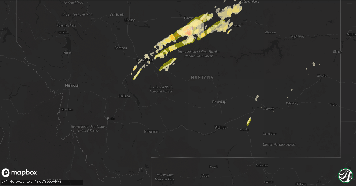
Hail Map in Montana on May 28, 2014
Get this storm
May 28 map
$229
one time, instant access
Download today. No call, no setup
Keep the $229
Bought the map and want the full workflow? Apply the entire $229 to a subscription within 7 days. None of it is wasted.
Every map, not just this one
This buys you this map. Subscription and you get every map we run, in the markets you choose from a few cities to whole states to nationwide. Plus real-time alerts the moment a storm fires.
Contact data
Name, contact info, occupancy, even credit band for addresses in the footprint. You go from where it hit to who to call.
Become the source they trust
Unlimited branding weather history reports on demand. You already have the documented answer ready for the property owner, and you are the one who showed up with it.
Property data and RoofTrace estimates
Pull up any address you have got, its value and the exact code rules for that jurisdiction, straight from One Click Code. Then RoofTrace estimates the squares, pitch, and roof value, priced the way you price.
Storm reports in Montana
Montana
| Date | Description |
|---|---|
| 05/28/20146:58 PM CDT | A local report indicates 1.00 inch wind near FORT BENTON |
| 05/28/20146:55 PM CDT | A local report indicates 1.00 inch wind near HIGHWOOD |
| 05/28/20146:10 PM CDT | A local report indicates 1.00 inch wind near GREAT FALLS |
| 05/28/20145:37 PM CDT | A local report indicates 1.50 inch wind near 2 S CASCADE |
| 05/27/201411:54 PM CDT | Plentwood automated station measured 58 mph wind gust. |
| 05/27/201411:43 PM CDT | Comertown turnoff automated station measured 59 mph wind gust. |
| 05/27/201410:35 PM CDT | A local report indicates 60 MPH wind near 2 S WHITEWATER |
| 05/27/201410:00 PM CDT | Had some pea size hail |
| 05/27/20149:54 PM CDT | Updated to previous report of 72 mph at 850 pm |
| 05/27/20149:50 PM CDT | A local report indicates 72 MPH wind near 2 W BLOOMFIELD |
| 05/27/20149:50 PM CDT | Hail lasted about 20 minutes |
| 05/27/20149:49 PM CDT | A local report indicates 60 MPH wind near 14 S DODSON |
| 05/27/20149:28 PM CDT | A local report indicates 1.00 inch wind near 4 SSE HOGELAND |
| 05/27/20149:28 PM CDT | A local report indicates 60 MPH wind near 4 SSE HOGELAND |
| 05/27/20149:20 PM CDT | 60 mph wind gust at the fort belknap raws. Time of event is estimated. |
| 05/27/20149:15 PM CDT | A local report indicates 60 MPH wind near 8 W LINDSAY |
| 05/27/20149:14 PM CDT | Wind damage. Power line blown down. Small fire started. |
| 05/27/20148:51 PM CDT | Little rain or wind. |
| 05/27/20148:46 PM CDT | Hail still quarter size two hours after it fell. Was likely larger. Trees in the area stripped of leaves. 0.91 rain in a very short period of time. |
| 05/27/20148:46 PM CDT | Hail still quarter size two hours after it fell. Was likely larger. Trees in the area stripped of leaves. 0.91 rain in a very short period of time. |
| 05/27/20148:20 PM CDT | Vehicle and house siding were damaged |
| 05/27/20148:13 PM CDT | A local report indicates 2.00 inch wind near ROCKY BOY |
| 05/27/20148:08 PM CDT | Very little rain and light wind accompanied. |
| 05/27/20147:45 PM CDT | Reported 2 inch hail |
| 05/27/20147:35 PM CDT | A local report indicates 1.00 inch wind near 2 N SQUARE BUTTE |
| 05/27/20147:21 PM CDT | A local report indicates 60 MPH wind near 1 N LOMA |
| 05/27/20147:16 PM CDT | Radar estimate on time. Spotters returned home 45 minutes after event. Original hailstone could have been 2 inches or more. |
| 05/27/20147:13 PM CDT | Hail melted before spotter returned home. Original hailstone could have been 2 inches or more. |
| 05/27/20147:00 PM CDT | Very strong wind in addition to hail |
| 05/27/20147:00 PM CDT | Badger peak raws |
All States Impacted by Hail Map on May 28, 2014
Cities Impacted by Hail Map on May 28, 2014
- Dodson, MT
- Harlem, MT
- Big Sandy, MT
- Loma, MT
- Fort Benton, MT
- Providence Forge, VA
- Charles City, VA
- Quinton, VA
- Port Wentworth, GA
- Rincon, GA
- Guyton, GA
- Norman Park, GA
- Howard, OH
- Danville, OH
- San Benito, TX
- Harlingen, TX
- La Feria, TX
- Cascade, MT
- Yemassee, SC
- Woodsfield, OH
- Loring, MT
- South Padre Island, TX
- Port Isabel, TX
- Rio Hondo, TX
- Los Fresnos, TX
- Uvalda, GA
- Lyons, GA
- Bayboro, NC
- Hays, MT
- Perrysville, OH
- Chinook, MT
- Wrightsville, GA
- Kite, GA
- Adrian, GA
- Smithfield, WV
- Geyser, MT
- Box Elder, MT
- Havre, MT
- Gambier, OH
- Blowing Rock, NC
- Collettsville, NC
- Whitewater, MT
- Turner, MT
- Raynesford, MT
- Malta, MT
- Savannah, GA
- Okeechobee, FL
- Goode, VA
- Bedford, VA
- McAlpin, FL
- Sun River, MT
- Doswell, VA
- Beaverdam, VA
- Lloyd, MT
- Bath, NC
- Warrenton, VA
- Marshall, VA
- Midland, VA
- Catlett, VA
- Rio Grande City, TX
- Garciasville, TX
- Clover, VA
- Hardin, MT
- Seabrook, SC
- Hogeland, MT
- North Port, FL
- Geraldine, MT
- Lithia, FL
- Riverview, FL
- Ashland, VA
- Highwood, MT
- Carter, MT
- Fargo, GA
- Myakka City, FL
- Parrish, FL
- Kokomo, IN
- Greentown, IN
- Forsyth, MT
- Eighty Four, PA
- Nathalie, VA
- Scottsburg, VA
- Sistersville, WV
- Friendly, WV
- Lake City, FL
- White Springs, FL
- Great Falls, MT
- Thomaston, AL
- Arlington, AL
- Varnville, SC
- Early Branch, SC
- Kewanna, IN
- Weslaco, TX
- Mercedes, TX
- Live Oak, FL
- Center Point, WV
- Gordo, AL
- Elrod, AL
- Pooler, GA
- Star City, IN
- Mazon, IL
- Ulm, MT
- Sardis, OH
- Sand Coulee, MT
- Proctor, WV
- Clarington, OH
- Linn, KS
- East Dublin, GA
- Rochester, IN
- Zurich, MT
- Cameron, OH
- Beallsville, OH
- Jerusalem, OH
- Swanton, OH
- Whitehouse, OH
- Angela, MT
- Bloomfield, MT
- Merry Hill, NC
- Roper, NC
- Dunkirk, OH
- Forest, OH
- Kenton, OH
- Dixie, GA
- Alva, FL
- Lehigh Acres, FL
- Kinsey, MT
- San Juan, TX
- Floweree, MT
- Clay Center, KS
- Stockett, MT
- Amboy, IN
- Arcadia, FL
- Port Charlotte, FL
- Colony, KS
- Grulla, TX
- Sullivan City, TX
- Royal Center, IN
- Punta Gorda, FL
- North Fort Myers, FL
- Canonsburg, PA
- Washington, PA
- Houston, PA
- Coffee Creek, MT
- Islandton, SC
- Halifax, VA
- Bighorn, MT
- Washington, NC
- Lindsay, MT
- Bealeton, VA
- Jacobsburg, OH
- Powhatan Point, OH
- Belmont, OH
- Pembroke, GA
- Wetumpka, AL
- Windsor, NC
- Medora, ND
- Brownsville, TX
- Ochopee, FL
- Boston, GA
- Quitman, GA
- Millen, GA
- Caret, VA
- Glen Easton, WV
- Moundsville, WV
- Greenville, FL
- Dover, OH
- Sugarcreek, OH
- Rosebud, MT
- Eureka, KS
- Crossville, TN
- Richmond, OH
- Palmer, KS
- Belhaven, NC
- Fredericksburg, VA
- Black Eagle, MT
- Parsons, WV
- Edinburg, TX
- Lawtey, FL
- Saint Marys, WV
- Glendive, MT
- Montross, VA
- Colonial Beach, VA
- Morriston, FL
- Steubenville, OH
- Toronto, OH


