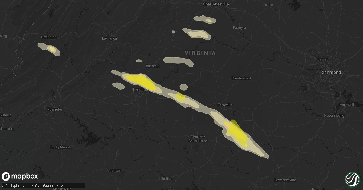
Hail Map in Appomattox, VA on May 27, 2026
Get this storm
May 27 map
$229
one time, instant access
Download today. No call, no setup
Keep the $229
Bought the map and want the full workflow? Apply the entire $229 to a subscription within 7 days. None of it is wasted.
Every map, not just this one
This buys you this map. Subscription and you get every map we run, in the markets you choose from a few cities to whole states to nationwide. Plus real-time alerts the moment a storm fires.
Contact data
Name, contact info, occupancy, even credit band for addresses in the footprint. You go from where it hit to who to call.
Become the source they trust
Unlimited branding weather history reports on demand. You already have the documented answer ready for the property owner, and you are the one who showed up with it.
Property data and RoofTrace estimates
Pull up any address you have got, its value and the exact code rules for that jurisdiction, straight from One Click Code. Then RoofTrace estimates the squares, pitch, and roof value, priced the way you price.
Storm reports in Appomattox, VA
Appomattox, VA
| Date | Description |
|---|---|
| 05/26/20267:08 PM CDT | A large tree was blown down by thunderstorm winds near the intersection of morning star road and s fork road. |
| 05/26/20267:01 PM CDT | A large tree was blown down by thunderstorm winds along walton drive. |
| 05/26/20267:00 PM CDT | Power line down near the intersection of police tower road and richmond highway near appomattox... Va. Time is estimated from radar. |
All States Impacted by Hail Map on May 27, 2026
All Cities Impacted by Hail Map on May 27, 2026
- Ingleside, TX
- Corpus Christi, TX
- Port Aransas, TX
- Los Fresnos, TX
- Port Isabel, TX
- Loretto, VA
- Montross, VA
- Champlain, VA
- Hustle, VA
- Colonial Beach, VA
- Caret, VA
- Warsaw, VA
- Kinsale, VA
- Callao, VA
- Hague, VA
- Farnham, VA
- Middlebourne, WV
- New Martinsville, WV
- Pine Grove, WV
- Reader, WV
- Porters Falls, WV
- Burgess, VA
- Reedville, VA
- Heathsville, VA
- Sistersville, WV
- Jacksonburg, WV
- Smithfield, WV
- Charlottesville, VA
- Cascade, VA
- Pelham, NC
- Big Springs, WV
- Coxs Mills, WV
- Auburn, WV
- Berea, WV
- West Union, WV
- Ola, ID
- Ruffin, NC
- Troy, WV
- Linn, WV
- Alum Bridge, WV
- Gleason, WI
- Merrill, WI
- Glenville, WV
- Deerbrook, WI
- Montrose, WV
- Philippi, WV
- Parsons, WV
- Antigo, WI
- Wausau, WI
- Athens, WI
- Weston, WV
- Schofield, WI
- Cascade, ID
- Faber, VA
- Indian Valley, ID
- Spencer, WV
- Rothschild, WI
- North Garden, VA
- Scottsville, VA
- Esmont, VA
- Schuyler, VA
- Mosinee, WI
- Marathon, WI
- Lovingston, VA
- Arnoldsburg, WV
- Alderson, WV
- Ringle, WI
- Keene, VA
- Council, ID
- Mccall, ID
- Edgar, WI
- Shipman, VA
- Wingina, VA
- Warrenton, NC
- Norlina, NC
- Junction City, WI
- Stevens Point, WI
- Covington, VA
- Stratford, WI
- New Meadows, ID
- Macon, NC
- Amherst, VA
- Norwood, VA
- Gladstone, VA
- Arrington, VA
- Plover, WI
- Littleton, NC
- Auburndale, WI
- Eagle Rock, VA
- Lakeview, OR
- Buckingham, VA
- Roanoke Rapids, NC
- Halifax, NC
- Wisconsin Rapids, WI
- Loyal, WI
- Chili, WI
- Spencer, WI
- Granton, WI
- Arpin, WI
- Marshfield, WI
- Milladore, WI
- Enfield, NC
- Bancroft, WI
- Bedford, VA
- Big Island, VA
- Bonanza, OR
- Coleman Falls, VA
- Lynchburg, VA
- Monroe, VA
- Greenwood, WI
- Bly, OR
- Goode, VA
- Owen, WI
- Sprague River, OR
- Beatty, OR
- Chiloquin, OR
- Madison Heights, VA
- Pittsville, WI
- Fall Creek, WI
- Hancock, WI
- Forest, VA
- Neillsville, WI
- Concord, VA
- Coloma, WI
- Appomattox, VA
- Friendship, WI
- Augusta, WI
- Warrenton, VA
- The Plains, VA
- Dairy, OR
- Klamath Falls, OR
- Westfield, WI
- Oxford, WI
- Grand Marsh, WI
- Spout Spring, VA
- Wisconsin Dells, WI
- Bennett, NC
- Seagrove, NC
- Pamplin, VA
- Briggsville, WI
- Portage, WI
- Endeavor, WI
- Baraboo, WI
- Keno, OR
- Ashland, OR
- Prospect, VA
- Hampden Sydney, VA
- Farmville, VA
- Meherrin, VA
- Green Bay, VA
- Burkeville, VA
- Black River Falls, WI
- Victoria, VA
- Polebridge, MT
- Hixton, WI
- Keysville, VA
- Victor, MT
- Merrimac, WI
- Crewe, VA
- Prairie Du Sac, WI
- Lenore, WV
- Dingess, WV
- Elk City, ID
- Kenbridge, VA
- Dundas, VA
- Blackstone, VA
- Marshall, VA
- Nokesville, VA
- Catlett, VA
- Trementina, NM
- Las Vegas, NM
- Ocate, NM
- Crowell, TX
- Seymour, TX
- Bonner, MT
- Boulder, MT
- Choteau, MT
- Fairfield, MT
- Dutton, MT


