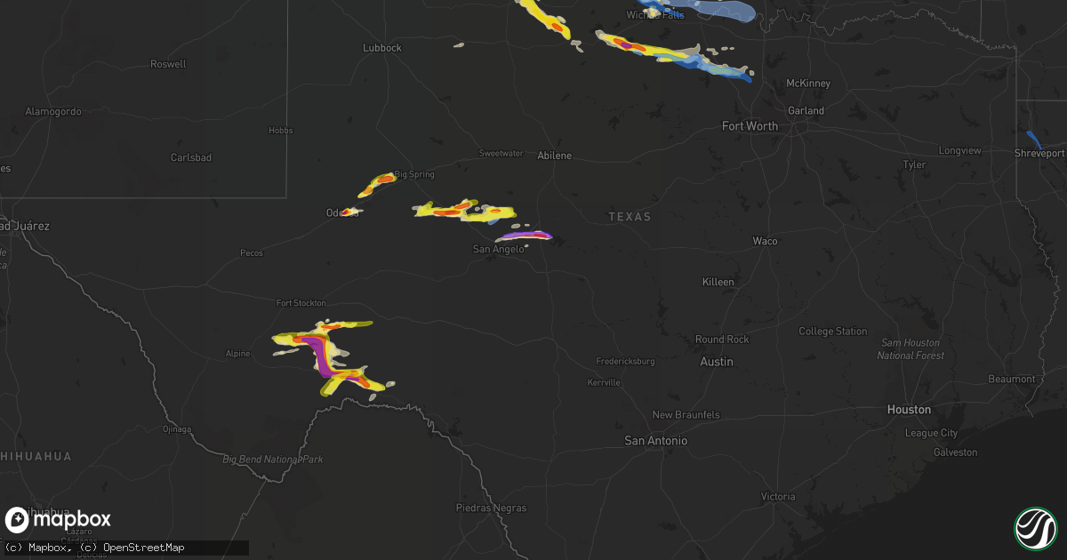
Hail Map in Texas on May 27, 2021
Get this storm
May 27 map
$229
one time, instant access
Download today. No call, no setup
Keep the $229
Bought the map and want the full workflow? Apply the entire $229 to a subscription within 7 days. None of it is wasted.
Every map, not just this one
This buys you this map. Subscription and you get every map we run, in the markets you choose from a few cities to whole states to nationwide. Plus real-time alerts the moment a storm fires.
Contact data
Name, contact info, occupancy, even credit band for addresses in the footprint. You go from where it hit to who to call.
Become the source they trust
Unlimited branding weather history reports on demand. You already have the documented answer ready for the property owner, and you are the one who showed up with it.
Property data and RoofTrace estimates
Pull up any address you have got, its value and the exact code rules for that jurisdiction, straight from One Click Code. Then RoofTrace estimates the squares, pitch, and roof value, priced the way you price.
Storm reports in Texas
Texas
| Date | Description |
|---|---|
| 05/27/20215:50 PM CDT | Golfball size hail reported on hwy 285 |
| 05/27/20215:50 PM CDT | Golfball size hail reported on hwy 285 |
| 05/27/20215:30 PM CDT | Ping-pong to quarters reported on 250 east loop |
| 05/27/20215:16 PM CDT | Mping report of quarter size hail near 191 and loop 250. |
| 05/27/20214:45 PM CDT | Social media photo showing 2 inch hail at south dixie in odessa. |
| 05/27/20214:35 PM CDT | Hail up to the size of half dollars covering the ground. |
| 05/27/20214:31 PM CDT | Pool ball size hail was reported. |
| 05/27/20214:30 PM CDT | A local report indicates 1.00 inch wind near 5 ENE ODESSA |
| 05/27/202110:30 AM CDT | Shed and window damage. Time estimated by radar |
| 05/27/20216:27 AM CDT | At 1127 PM CDT, a severe thunderstorm was located 4 miles northeast of Truscott, moving southeast at 30 mph. HAZARD...Two inch hail and 60 mph wind gusts. SOURCE...Radar indicated. IMPACT...People and animals outdoors will be injured. Expect hail damage to roofs, siding, windows, and vehicles. Expect wind damage to roofs, siding, and trees. Locations impacted include... Red Springs, Truscott, Gilliland, Vera and Bomarton. |
| 05/27/20216:11 AM CDT | At 1111 PM CDT, severe thunderstorms were located along a line extending from 5 miles east of Grady to 8 miles southeast of Oscar to near Nocona, moving east at 40 mph. HAZARD...60 mph wind gusts. SOURCE...Radar indicated. IMPACT...Expect damage to roofs, siding, and trees. Locations impacted include... Marietta, Thackerville, Leon, Overbrook, Grady, Rubottom, Burneyville, southern Lake Murray, Courtney and Petersburg. |
| 05/27/20216:00 AM CDT | At 1100 PM CDT, a severe thunderstorm was located 14 miles northwest of Truscott, moving southeast at 20 mph. HAZARD...Ping pong ball size hail and 60 mph wind gusts. SOURCE...Radar indicated. IMPACT...People and animals outdoors will be injured. Expect hail damage to roofs, siding, windows, and vehicles. Expect wind damage to roofs, siding, and trees. Locations impacted include... Truscott. |
| 05/27/20215:36 AM CDT | At 1036 PM CDT, a severe thunderstorm was located 10 miles southeast of Swearingen, moving east at 25 mph. HAZARD...60 mph wind gusts and quarter size hail. SOURCE...Radar indicated. IMPACT...Hail damage to vehicles is expected. Expect wind damage to roofs, siding, and trees. Locations impacted include... Crowell. |
| 05/27/20215:28 AM CDT | At 1028 PM CDT, a severe thunderstorm was located 7 miles south of Swearingen, or 10 miles east of Paducah, moving east at 15 mph. HAZARD...Ping pong ball size hail and 60 mph wind gusts. SOURCE...Radar indicated. IMPACT...People and animals outdoors will be injured. Expect hail damage to roofs, siding, windows, and vehicles. Expect wind damage to roofs, siding, and trees. Locations impacted include... Hackberry. |
| 05/27/20214:57 AM CDT | A local report indicates 1.25 inch wind near FRIONA |
| 05/27/20214:55 AM CDT | A local report indicates 1.25 inch wind near 1 W FRIONA |
| 05/27/20213:41 AM CDT | At 841 PM CDT, a severe thunderstorm was located near Dryden, moving southeast at 20 mph. HAZARD...Tennis ball size hail and 70 mph wind gusts. SOURCE...Radar indicated. IMPACT...People and animals outdoors will be injured. Expect hail damage to roofs, siding, windows, and vehicles. Expect considerable tree damage. Wind damage is also likely to mobile homes, roofs, and outbuildings. Locations impacted include... Sanderson, Dryden and Terrell County Airport. |
| 05/27/20213:39 AM CDT | At 839 PM CDT, a severe thunderstorm was located over Harriet, moving east at 35 mph. HAZARD...60 mph wind gusts and half dollar size hail. SOURCE...Radar indicated. IMPACT...Hail damage to vehicles is expected. Expect wind damage to roofs, siding, and trees. This severe thunderstorm will be near... Miles around 855 PM CDT. Rowena around 910 PM CDT. Ballinger around 925 PM CDT. Benoit around 935 PM CDT.Other locations impacted by this severe thunderstorm includeBallinger Lake and Us-83 Near The Concho-Runnels County Line. |
| 05/27/20213:26 AM CDT | At 825 PM CDT, a severe thunderstorm was located 6 miles west of Chillicothe, moving east-southeast at 25 mph. Hail to the size of tennis balls has been reported at Quanah. This storm will affect motorists along U.S. Highway 287 between Quanah and Vernon. HAZARD...Tennis ball size hail and 60 mph wind gusts. SOURCE...Radar indicated. IMPACT...People and animals outdoors will be injured. Expect hail damage to roofs, siding, windows, and vehicles. Expect wind damage to roofs, siding, and trees. Locations impacted include... Chillicothe. |
| 05/27/20213:11 AM CDT | At 810 PM CDT, a severe thunderstorm was located near Bronte, moving east at 25 mph. HAZARD...60 mph wind gusts and half dollar size hail. SOURCE...Radar indicated. IMPACT...Hail damage to vehicles is expected. Expect wind damage to roofs, siding, and trees. This severe thunderstorm will be near... Bronte around 825 PM CDT. Maverick around 840 PM CDT. Norton around 850 PM CDT. Ballinger and Hatchel around 915 PM CDT.Other locations impacted by this severe thunderstorm includeBallinger Lake, The Intersection Of Highway 208 And Ranch Road 2662and Us-87 Near The Coke-Tom Green County Line. |
| 05/27/20213:10 AM CDT | At 810 PM CDT, a severe thunderstorm was located over Swearingen, or 13 miles northeast of Paducah, moving northeast at 30 mph. HAZARD...Ping pong ball size hail and 60 mph wind gusts. SOURCE...Radar indicated. IMPACT...People and animals outdoors will be injured. Expect hail damage to roofs, siding, windows, and vehicles. Expect wind damage to roofs, siding, and trees. Locations impacted include... Paducah and Swearingen. |
| 05/27/20213:09 AM CDT | Trees down on cr 430. |
| 05/27/20213:04 AM CDT | Trees down on fm 999 just east of cr 420. |
| 05/27/20213:02 AM CDT | Trees down on cr 193. |
| 05/27/20212:51 AM CDT | At 751 PM CDT, a severe thunderstorm was located 4 miles northeast of Goodlett, moving east at 20 mph. HAZARD...60 mph wind gusts and quarter size hail. SOURCE...Radar indicated. IMPACT...Hail damage to vehicles is expected. Expect wind damage to roofs, siding, and trees. Locations impacted include... Quanah and Goodlett. |
| 05/27/20212:43 AM CDT | Trees down on county road 325 near de berry. |
| 05/27/20212:40 AM CDT | At 740 PM CDT, a severe thunderstorm was located near Sterling City, moving east at 30 mph. HAZARD...60 mph wind gusts and quarter size hail. SOURCE...Radar indicated. IMPACT...Hail damage to vehicles is expected. Expect wind damage to roofs, siding, and trees. This severe thunderstorm will be near... E.V. Spence Reservoir Near Paint Creek Recreation Area around 825 PM CDT. Robert Lee and Sanco around 835 PM CDT.Other locations impacted by this severe thunderstorm include TheIntersection Of Highway 158 And Ranch Road 2059. |
| 05/27/20212:39 AM CDT | Trees down on fm 1794 near de berry. |
| 05/27/20212:30 AM CDT | Social media report several large trees uprooted or large branches down in denton creek farms and in a nearby neighborhood. Time estimated by radar. |
| 05/27/20212:28 AM CDT | At 728 PM CDT, a severe thunderstorm was located near Garden City, and is nearly stationary. HAZARD...60 mph wind gusts and half dollar size hail. SOURCE...Radar indicated. IMPACT...Hail damage to vehicles is expected. Expect wind damage to roofs, siding, and trees. Locations impacted include... Garden City and Saint Lawrence. |
| 05/27/20212:18 AM CDT | A number of trees and power lines are downed in marshall. |
| 05/27/20212:12 AM CDT | Social media report of several trees uprooted or large branches down 5 miles north of decatur. Time estimated by radar. |
| 05/27/20212:12 AM CDT | At 711 PM CDT, a severe thunderstorm was located 7 miles west of Sanderson, moving southeast at 15 mph. HAZARD...Tennis ball size hail and 70 mph wind gusts. SOURCE...Radar indicated. IMPACT...People and animals outdoors will be injured. Expect hail damage to roofs, siding, windows, and vehicles. Expect considerable tree damage. Wind damage is also likely to mobile homes, roofs, and outbuildings. Locations impacted include... Sanderson, Dryden and Terrell County Airport. |
| 05/27/20212:05 AM CDT | Tree down across old longview road at morningside drive. |
| 05/27/20212:04 AM CDT | At 704 PM CDT, a severe thunderstorm was located 7 miles northwest of Brice, or 10 miles southwest of Clarendon, moving northeast at 30 mph. HAZARD...60 mph wind gusts and half dollar size hail. SOURCE...Radar indicated. IMPACT...Minor damage to roofs, siding, and trees is possible. Hail damage to vehicles is expected. Locations impacted include... Clarendon, Hedley, Lelia Lake and Greenbelt Lake. |
| 05/27/20212:00 AM CDT | Tree down across fm 2908 south of highway 271. |
| 05/27/20212:00 AM CDT | Several trees were snapped/downed across lavender road near i-20. |
| 05/27/20211:57 AM CDT | Tree down across fm 2015 south of fm 16. |
| 05/27/20211:55 AM CDT | At 655 PM CDT, a severe thunderstorm was located over Valley Schools, or 4 miles southeast of Caprock Canyon State Park, moving southeast at 25 mph. HAZARD...60 mph wind gusts and quarter size hail. SOURCE...Radar indicated. IMPACT...Hail damage to vehicles is expected. Expect wind damage to roofs, siding, and trees. Locations impacted include... Turkey, Caprock Canyon State Park, Quitaque, Flomot, Valley Schools and Northfield. |
| 05/27/20211:40 AM CDT | At 639 PM CDT, a severe thunderstorm was located near Sterling City, moving east at 35 mph. HAZARD...60 mph wind gusts and half dollar size hail. SOURCE...Radar indicated. IMPACT...Hail damage to vehicles is expected. Expect wind damage to roofs, siding, and trees. This severe thunderstorm will be near... E.V. Spence Reservoir Near Paint Creek Recreation Area around 715 PM CDT. Robert Lee and Sanco around 725 PM CDT. Blackwell and Fort Chadbourne around 745 PM CDT.Other locations impacted by this severe thunderstorm include OakCreek Reservoir and The Intersection Of Highway 158 And Ranch Road2059. |
| 05/27/20211:15 AM CDT | At 614 PM CDT, a severe thunderstorm was located 13 miles south of Garden City, moving east at 15 mph. Other severe storms were near Garden City. HAZARD...60 mph wind gusts and half dollar size hail. SOURCE...Radar indicated. IMPACT...Hail damage to vehicles is expected. Expect wind damage to roofs, siding, and trees. Locations impacted include... Garden City and Saint Lawrence and rural areas east of Saint Lawrence. |
| 05/27/20211:03 AM CDT | At 602 PM CDT, a severe thunderstorm was located 20 miles northwest of Sanderson, moving southeast at 20 mph. This is a very dangerous storm. HAZARD...Baseball size hail and 70 mph wind gusts. SOURCE...Radar indicated. IMPACT...People and animals outdoors will be severely injured. Expect shattered windows, extensive damage to roofs, siding, and vehicles. Locations impacted include... Sheffield, Sanderson, Terrell County Airport and Sierra Madera. This includes Interstate 10 between mile markers 270 and 289. |
| 05/27/202112:25 AM CDT | At 524 PM CDT, a severe thunderstorm was located 22 miles southeast of Fort Stockton, moving northeast at 10 mph. HAZARD...Two inch hail and 70 mph wind gusts. SOURCE...Radar indicated. IMPACT...People and animals outdoors will be injured. Expect hail damage to roofs, siding, windows, and vehicles. Expect considerable tree damage. Wind damage is also likely to mobile homes, roofs, and outbuildings. This severe thunderstorm will remain over mainly rural areas of central Pecos County.This includes Interstate 10 between mile markers 271 and 289. |
| 05/27/202112:14 AM CDT | At 514 PM CDT, a severe thunderstorm was located over Midland, moving east at 10 mph. HAZARD...60 mph wind gusts and half dollar size hail. SOURCE...Radar indicated. IMPACT...Hail damage to vehicles is expected. Expect wind damage to roofs, siding, and trees. Locations impacted include... Midland, Greenwood, Midland International Air and Space Port, Cotton Flat, Midland Airpark, Skywest Airport and Spraberry.This includes Interstate 20 between mile markers 128 and 153. |
| 05/27/202112:01 AM CDT | At 501 PM CDT, a severe thunderstorm was located 7 miles northwest of Stanton, or 11 miles north of Greenwood, moving northeast at 15 mph. HAZARD...60 mph wind gusts and quarter size hail. SOURCE...Radar indicated. IMPACT...Hail damage to vehicles is expected. Expect wind damage to roofs, siding, and trees. Locations impacted include... Stanton, Lenorah, Courtney, Big Spring McMahon-Wrinkle Airpark, Knott, Stanton Municipal Aiport and Elbow.This includes Interstate 20 between mile markers 152 and 174. |
| 05/26/202111:44 PM CDT | At 443 PM CDT, a severe thunderstorm was located 25 miles west of Sheffield, moving east at 25 mph. HAZARD...Tennis ball size hail and 70 mph wind gusts. SOURCE...Radar indicated. IMPACT...People and animals outdoors will be injured. Expect hail damage to roofs, siding, windows, and vehicles. Expect considerable tree damage. Wind damage is also likely to mobile homes, roofs, and outbuildings. Locations impacted include... Sheffield and Bakersfield. This includes Interstate 10 between mile markers 281 and 323. |
| 05/26/202111:41 PM CDT | At 440 PM CDT, a severe thunderstorm was located 19 miles north of Marathon, or 29 miles east of Alpine, moving southeast at 45 mph. HAZARD...70 mph wind gusts and half dollar size hail. SOURCE...Radar indicated. IMPACT...Hail damage to vehicles is expected. Expect considerable tree damage. Wind damage is also likely to mobile homes, roofs, and outbuildings. Locations impacted include... Fort Stockton, Marathon, Sierra Madera and Fort Stockton-Pecos County Airport.This includes Interstate 10 between mile markers 252 and 262. |
| 05/26/202111:19 PM CDT | At 419 PM CDT, a severe thunderstorm was located over Odessa, moving northeast at 30 mph. HAZARD...60 mph wind gusts and quarter size hail. SOURCE...Radar indicated. IMPACT...Hail damage to vehicles is expected. Expect wind damage to roofs, siding, and trees. Locations impacted include... Midland, Odessa, Midland International Air and Space Port, West Odessa, Warfield and Odessa Schlemeyer Field.This includes Interstate 20 between mile markers 116 and 130. |
| 05/26/202110:45 PM CDT | At 345 PM CDT, a severe thunderstorm was located 29 miles southeast of Fort Stockton, moving east at 5 mph. HAZARD...70 mph wind gusts and ping pong ball size hail. SOURCE...Radar indicated. IMPACT...People and animals outdoors will be injured. Expect hail damage to roofs, siding, windows, and vehicles. Expect considerable tree damage. Wind damage is also likely to mobile homes, roofs, and outbuildings. Locations impacted include... Bakersfield.This includes Interstate 10 between mile markers 280 and 300. |
| 05/26/202110:36 PM CDT | Exit 3c on i-44 |
| 05/26/202110:30 PM CDT | Shed and window damage. Time estimated by radar |
| 05/26/202110:25 PM CDT | A local report indicates 62 MPH wind near SHEPPARD AFB |
| 05/26/202110:19 PM CDT | A local report indicates 1.00 inch wind near BURKBURNETT |
| 05/26/202110:13 PM CDT | A local report indicates 1.25 inch wind near 3 W BURKBURNETT |
| 05/26/20219:15 PM CDT | A local report indicates 62 MPH wind near 1 WSW ROWENA |
| 05/26/20219:02 PM CDT | Report from mping. |
| 05/26/20218:30 PM CDT | A local report indicates 1.00 inch wind near STERLING CITY |
| 05/26/20218:28 PM CDT | Spotternetwork report. |
| 05/26/20218:20 PM CDT | A local report indicates 1.00 inch wind near STERLING CITY |
| 05/26/20218:20 PM CDT | A local report indicates 1.50 inch wind near 6 WNW STERLING CITY |
| 05/26/20218:15 PM CDT | Twitter photo. |
| 05/26/20218:13 PM CDT | Nwschat report. |
| 05/26/20217:30 PM CDT | Hail up to 2 inches reported in sterling city. |
| 05/26/20217:30 PM CDT | Spotter photo of hail up to 2 inches in diameter. |
| 05/26/20217:07 PM CDT | A local report indicates 1.50 inch wind near 1 SSE TURKEY |
| 05/26/20217:01 PM CDT | A local report indicates 1.00 inch wind near 1 NNE TURKEY |
All States Impacted by Hail Map on May 27, 2021
Cities Impacted by Hail Map on May 27, 2021
- Longdale, OK
- Glenwood, AR
- Caddo Gap, AR
- Kansas City, KS
- Barnsdall, OK
- Ochelata, OK
- Bartlesville, OK
- Wynona, OK
- Pawhuska, OK
- Chandler, OK
- Muse, OK
- Okemah, OK
- Sterling City, TX
- Garden City, TX
- Virden, IL
- Modesto, IL
- Girard, IL
- Dimmitt, TX
- Randlett, OK
- Electra, TX
- Davidson, OK
- Grandfield, OK
- Iowa Park, TX
- Wichita Falls, TX
- Burkburnett, TX
- Weleetka, OK
- Foristell, MO
- Wentzville, MO
- Wright City, MO
- Marthasville, MO
- Harper, KS
- Henryetta, OK
- Quinton, OK
- Stigler, OK
- Eufaula, OK
- Red Oak, OK
- Kinta, OK
- Mccurtain, OK
- Seymour, TX
- Murrayville, IL
- Bonner Springs, KS
- Linwood, KS
- Tonganoxie, KS
- Basehor, KS
- Wellington, KS
- Quanah, TX
- Vernon, TX
- Salem, AR
- Bexar, AR
- Glencoe, AR
- Ash Flat, AR
- Horseshoe Bend, AR
- Oxford, AR
- Wiseman, AR
- Chico, TX
- Decatur, TX
- Alvord, TX
- Peru, KS
- Kress, TX
- Silverton, TX
- Tulia, TX
- Corn, OK
- Colony, OK
- Friona, TX
- Hennessey, OK
- Okeene, OK
- Kingfisher, OK
- Liberty, MO
- Kansas City, MO
- Excelsior Springs, MO
- Vinita, OK
- Odessa, TX
- Kremlin, OK
- Hillsboro, MO
- Rogers, AR
- Council Hill, OK
- Stanton, TX
- Midland, TX
- Wister, OK
- Riverside, MO
- Ames, OK
- Ringwood, OK
- Fairview, OK
- Meno, OK
- Isabella, OK
- Robert Lee, TX
- Quitaque, TX
- Turkey, TX
- Arkansas City, KS
- Wellston, OK
- Davenport, OK
- Luther, OK
- Chelsea, OK
- Pacific, MO
- Chester, OK
- Wagoner, OK
- Porter, OK
- Lebanon, MO
- Conway, MO
- Grovespring, MO
- Dryden, TX
- Marathon, TX
- Sanderson, TX
- Ryan, OK
- Waurika, OK
- Marshall, OK
- Crescent, OK
- Mulhall, OK
- Miles, TX
- Ballinger, TX
- Rowena, TX
- Edmond, OK
- Dickens, TX
- Talihina, OK
- Hunter, OK
- Springdale, AR
- Paducah, TX
- Crowell, TX
- Greenfield, IL
- Carrollton, IL
- White Hall, IL
- Rockbridge, IL
- Big Cabin, OK
- Fort Stockton, TX
- Flora, IL
- Clay City, IL
- Labadie, MO
- Arcadia, OK
- Guthrie, OK
- Winchester, IL
- Roodhouse, IL
- Depew, OK
- Sparks, OK
- Meeker, OK
- Paden, OK
- Boley, OK
- Castle, OK
- Prague, OK
- Stroud, OK
- Martin, TN
- Pea Ridge, AR
- Bentonville, AR
- Canadian, OK
- Mcalester, OK
- Okmulgee, OK
- Batesville, AR
- Sulphur Rock, AR
- Charlotte, AR
- Newark, AR
- Cashion, OK
- Edgewood, IL
- Farina, IL
- Louisville, IL
- Chillicothe, TX
- Vian, OK
- Marland, OK
- Ponca City, OK
- Fayetteville, AR
- Jet, OK
- Pond Creek, OK
- Pampa, TX
- Nash, OK
- Perkins, OK
- Meridian, OK
- Devol, OK
- Sedan, KS
- Havana, KS
- Niotaze, KS
- Enid, OK
- Orlando, OK
- Pearl, IL
- Pittsfield, IL
- San Angelo, TX
- Paint Rock, TX
- Clovis, NM
- Mcalister, NM
- Melrose, NM
- Garfield, AR
- Bella Vista, AR
- Adair, OK
- Rush Springs, OK
- Carrier, OK
- Carmen, OK
- Goltry, OK
- Helena, OK
- Krum, TX
- Gray Summit, MO
- Villa Ridge, MO
- Waterloo, IL
- West Salem, IL
- Mount Erie, IL
- Winfield, KS
- Holliday, TX
- Carney, OK
- Tryon, OK
- Coyle, OK
- Ramona, OK
- Collinsville, OK
- Checotah, OK
- Henderson, TN
- Fairmont, OK
- Perry, OK
- Covington, OK
- Garber, OK
- Sheppard Afb, TX
- Jacksboro, TX
- Windthorst, TX
- Bowie, TX
- Henrietta, TX
- Bellevue, TX
- Comanche, OK
- Viola, AR
- Violet Hill, AR
- Elizabeth, AR
- Niangua, MO
- Hartville, MO
- South Fulton, TN
- Fulton, KY
- Hoxie, AR
- Walnut Ridge, AR
- Alicia, AR
- Dover, OK
- Loyal, OK
- Drummond, OK
- Troy, MO
- Warrenton, MO
- Hawk Point, MO
- Saint Peter, IL
- Red Bud, IL
- New Athens, IL
- Freeman, MO
- Peculiar, MO
- Kampsville, IL
- Nebo, IL
- Windyville, MO
- Phillipsburg, MO
- Long Lane, MO
- Cleo Springs, OK
- Braman, OK
- Mount Vernon, IL
- Waltonville, IL
- Ashley, IL
- Woodlawn, IL
- Geuda Springs, KS
- South Haven, KS
- Medford, OK
- Bristow, OK
- Bronte, TX
- Kinmundy, IL
- Powell, MO
- Seiling, OK
- Canton, OK
- Taloga, OK
- Watonga, OK
- Oakwood, OK
- Hitchcock, OK
- Comstock, TX
- Dixon, MO
- Okarche, OK
- Hindsville, AR
- Truesdale, MO
- Harrah, OK
- Mcloud, OK
- Piedmont, OK
- Spencer, OK
- Agra, OK
- Hanna, OK
- Smithville, OK
- Mena, AR
- Whitesboro, OK
- Jones, OK
- Wetumka, OK
- Hatfield, AR
- Wilburton, OK
- Dustin, OK
- Hodgen, OK
- Heavener, OK
- Oklahoma City, OK
- Morris, OK
- Choctaw, OK
- Yukon, OK
- Clarendon, TX
- Kevil, KY
- Lowell, AR
- Fults, IL
- Mayfield, KS
- Caldwell, KS
- Milan, KS
- Anadarko, OK
- Duncan, OK
- Washburn, MO
- Mooreland, OK
- Washington, MO
- Huntsville, AR
- Berryville, AR
- Sunset, TX
- Ringling, OK
- Loveland, OK
- Walters, OK
- Hillview, IL
- Griggsville, IL
- Milton, IL
- New Salem, IL
- Hominy, OK
- Pocasset, OK
- Chickasha, OK
- Burlington, KS
- Bovina, TX
- Silex, MO
- O'Fallon, MO
- Marshfield, MO
- Jonesburg, MO
- Butler, MO
- Urich, MO
- Oologah, OK
- Greenfield, TN
- Kenton, TN
- Sharon, TN
- House Springs, MO
- Imperial, MO
- Barnhart, MO
- Danville, KS
- Freeport, KS
- Argonia, KS
- Anthony, KS
- Baldwin, IL
- Newburg, MO
- Smithville, MO
- New Bern, NC
- Rolla, MO
- Cedar Hill, MO
- Dittmer, MO
- Owensville, MO
- Bland, MO
- Minco, OK
- Loco, OK
- Texico, NM
- Nowata, OK
- Clinton, KY
- Lockney, TX
- Matador, TX
- Cedar Vale, KS
- Pineville, MO
- Franklin, IL
- Verden, OK
- Cement, OK
- Tonkawa, OK
- Xenia, IL
- Mason, IL
- Edinburg, IL
- Palmyra, IL
- Spur, TX
- Talala, OK
- Skiatook, OK
- Cave City, AR
- Clinton, AR
- Shirley, AR
- Archer City, TX
- Vichy, MO
- Tunas, MO
- Olathe, KS
- Saint Jo, TX
- Childress, TX
- Lawrence, KS
- Rudy, AR
- Cedarville, AR
- El Reno, OK
- Harrold, TX
- Oklaunion, TX
- Waukomis, OK
- Forestburg, TX
- Sallisaw, OK
- Petrolia, TX
- Henderson, AR
- Gamaliel, AR
- Gepp, AR
- Redbird, OK
- Pawnee, IL
- Morrisonville, IL
- Jay, OK
- Waggoner, IL
- Independence, KS
- Omega, OK
- West Fork, AR
- Vandalia, IL
- Brownstown, IL
- Marlow, OK
- Lahoma, OK
- Sheffield, TX
- Norton, TX
- Lake Saint Louis, MO
- Pleasant Hope, MO
- Stockton, MO
- Fair Play, MO
- Strafford, MO
- Fair Grove, MO
- Buffalo, MO
- Bolivar, MO
- Dunnegan, MO
- Humansville, MO
- Morrisville, MO
- Elkland, MO
- Half Way, MO
- Brighton, MO
- Falcon, MO
- Louisburg, MO
- Flemington, MO
- Mountain Grove, MO
- Polk, MO
- Weaubleau, MO
- Saint Albans, MO
- Belle, MO
- Saint James, MO
- Cuba, MO
- Leasburg, MO
- Sailor Springs, IL
- Noble, IL
- Dundas, IL
- Newton, IL
- Ingraham, IL
- Olney, IL
- Waldron, AR
- Nocona, TX
- Terral, OK
- Burneyville, OK
- Gainesville, TX
- Overbrook, OK
- Byers, TX
- Muenster, TX
- Wilson, OK
- Marietta, OK
- Leon, OK
- Ponder, TX
- Columbia, IL
- Claremore, OK
- Vera, OK
- Catoosa, OK
- Sperry, OK
- Owasso, OK
- Tulsa, OK
- Fort Gibson, OK
- Bossier City, LA
- Shreveport, LA


