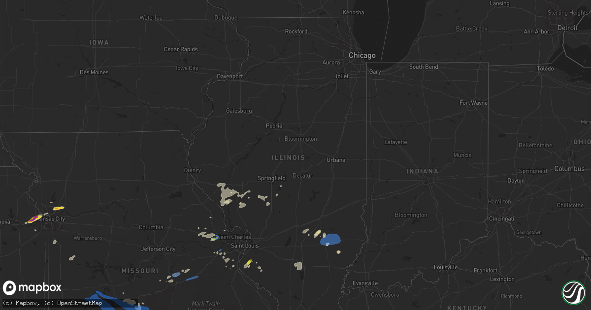
Hail Map in Illinois on May 27, 2021
Get this storm
May 27 map
$229
one time, instant access
Download today. No call, no setup
Keep the $229
Bought the map and want the full workflow? Apply the entire $229 to a subscription within 7 days. None of it is wasted.
Every map, not just this one
This buys you this map. Subscription and you get every map we run, in the markets you choose from a few cities to whole states to nationwide. Plus real-time alerts the moment a storm fires.
Contact data
Name, contact info, occupancy, even credit band for addresses in the footprint. You go from where it hit to who to call.
Become the source they trust
Unlimited branding weather history reports on demand. You already have the documented answer ready for the property owner, and you are the one who showed up with it.
Property data and RoofTrace estimates
Pull up any address you have got, its value and the exact code rules for that jurisdiction, straight from One Click Code. Then RoofTrace estimates the squares, pitch, and roof value, priced the way you price.
Storm reports in Illinois
Illinois
| Date | Description |
|---|---|
| 05/27/20214:52 PM CDT | Large oak tree fell onto the front of a home on maple street...causing damage. Time estimated from radar. |
| 05/27/20214:51 PM CDT | Tree uprooted on 27th street. Time estimated. Report related via twitter. |
| 05/27/20214:30 PM CDT | Broadcast media reports underpinning of a mobile home and a trampoline were blown away. Time estimated. |
| 05/27/20214:05 PM CDT | Tree limbs about 12 inches in diameter downed. |
| 05/27/20213:45 PM CDT | Damage to barn and debris through field. |
| 05/27/20213:45 PM CDT | Tree damage... Minor structure damage. |
| 05/27/20213:45 PM CDT | Trees downed. |
| 05/27/20213:38 PM CDT | Tree fell on cars. Relayed by ema. |
| 05/27/20213:30 PM CDT | No damage reported... Touched down in field. |
| 05/27/20213:15 PM CDT | Power line down. Relayed by ema. Time estimated by radar. |
| 05/27/20212:54 PM CDT | A local report indicates 1.00 inch wind near WATERLOO |
| 05/27/202112:52 PM CDT | Power pole leaning over. |
| 05/27/202112:50 PM CDT | Tree damage. Time estimated by radar. |
| 05/27/202112:44 PM CDT | Several large trees blown down. One large tree fell onto a pole barn causing moderate damage. Tree also knocked gas meter off of the house. |
| 05/27/202112:40 PM CDT | Numerous tree limbs down. Time estimated by radar. |
| 05/27/202112:35 PM CDT | Power lines and trees down in roadway. Time estimated by radar. |
| 05/27/202112:27 PM CDT | Numerous tree limbs and several trees blown down on the south side of godfrey. |
| 05/27/202112:23 PM CDT | 2 inch diameter tree limb blown off. |
| 05/27/202110:15 AM CDT | Power line and trees down. Time estimated by radar. Relayed by broadcast media. |
| 05/27/20217:07 AM CDT | At 1206 PM CDT, severe thunderstorms were located along a line extending from 6 miles south of Franklin to near Palmyra, moving east at 40 mph. HAZARD...70 mph wind gusts and nickel size hail. SOURCE...Radar indicated. IMPACT...Expect considerable tree damage. Damage is likely to mobile homes, roofs, and outbuildings. Severe thunderstorms will be near... Palmyra around 1210 PM CDT.Other locations in the path of these severe thunderstorms includeVirden and White Oak. |
| 05/27/20216:58 AM CDT | At 1158 AM CDT, severe thunderstorms were located along a line extending from near Jacksonville to Athensville, moving east at 40 mph. HAZARD...60 mph wind gusts and quarter size hail. SOURCE...Radar indicated. IMPACT...Hail damage to vehicles is expected. Expect wind damage to roofs, siding, and trees. Severe thunderstorms will be near... Alexander and Franklin around 1215 PM CDT.Other locations in the path of these severe thunderstorms includeWaverly, New Berlin, Loami, Auburn, Chatham, Divernon, Springfield,Pawnee, Sherman, Rochester and Riverton.This includes the following highways... Interstate 55 between mile markers 77 and 104. Interstate 72 between mile markers 61 and 107. |
| 05/27/20216:32 AM CDT | At 1132 AM CDT, severe thunderstorms were located along a line extending from near Alsey to 6 miles southwest of Carrollton, moving east at 40 mph. HAZARD...70 mph wind gusts and nickel size hail. SOURCE...Radar indicated. IMPACT...Expect considerable tree damage. Damage is likely to mobile homes, roofs, and outbuildings. Severe thunderstorms will be near... White Hall and Roodhouse around 1135 AM CDT. Carrollton around 1140 AM CDT.Other locations in the path of these severe thunderstorms includeGreenfield and Palmyra. |
| 05/27/20216:13 AM CDT | At 1112 AM CDT, severe thunderstorms were located along a line extending from near Elsberry to Moscow Mills to 6 miles southwest of Truesdale, moving northeast at 45 mph. HAZARD...60 mph wind gusts and nickel size hail. SOURCE...Radar indicated. IMPACT...Expect damage to roofs, siding, and trees. Severe thunderstorms will be near... Fountain N' Lakes around 1120 AM CDT. Winfield and Hardin around 1125 AM CDT.Other locations in the path of these severe thunderstorms includeWentzville, Carrollton, Lake St. Louis, St. Paul, Josephville, Chainof Rocks, Jerseyville, Greenfield and Old Kane.This includes Interstate 70 in Missouri between exits 199 and 227. This also includes Pere Marquette State Park. |
| 05/26/202111:31 PM CDT | At 430 PM CDT, severe thunderstorms were located along a line extending from near Woodlawn to 7 miles southwest of Ava, moving east at 45 mph. HAZARD...60 mph wind gusts and quarter size hail. SOURCE...Radar indicated. IMPACT...Hail damage to vehicles is expected. Expect wind damage to roofs, siding, and trees. Severe thunderstorms will be near... Mount Vernon around 440 PM CDT. Murphysboro around 450 PM CDT.Other locations in the path of these severe thunderstorms includeCarbondale, De Soto, Elkville, Royalton, Hurst, Carterville, Zeigler,Cambria, Marion, Herrin, Johnston City, Crainville and Energy. |
| 05/26/202110:47 PM CDT | At 347 PM CDT, severe thunderstorms were located along a line extending from near Bible Grove to Sailor Springs to 6 miles north of Cisne, moving east at 30 mph. HAZARD...60 mph wind gusts and quarter size hail. SOURCE...Radar indicated. IMPACT...Hail damage to vehicles is expected. Expect wind damage to roofs, siding, and trees. Severe thunderstorms will be near... Noble and Bogota around 400 PM CDT. Schnell around 405 PM CDT. Olney, Dundas and West Liberty around 415 PM CDT. Ste. Marie, Parkersburg and Calhoun around 425 PM CDT. Claremont around 435 PM CDT.Other locations impacted by these severe thunderstorms includeWakefield, Berryville and Olney Noble Airport. |
| 05/26/202110:06 PM CDT | At 306 PM CDT, severe thunderstorms were located along a line extending from near Edgewood to near Omega, moving east at 25 mph. HAZARD...60 mph wind gusts and quarter size hail. SOURCE...Radar indicated. IMPACT...Hail damage to vehicles is expected. Expect wind damage to roofs, siding, and trees. Severe thunderstorms will be near... Iola around 315 PM CDT. Xenia around 325 PM CDT. Louisville and Bible Grove around 340 PM CDT. Ingraham around 355 PM CDT. Clay City and Sailor Springs around 400 PM CDT.Other locations impacted by these severe thunderstorms includeWendelin, Newton Lake, Hord, Mason, Oskaloosa and Latona.This includes Interstate 57 between mile markers 142 and 147. |
| 05/26/202110:03 PM CDT | At 302 PM CDT, a severe thunderstorm was located near Omega, or 10 miles east of Salem, moving east at 30 mph. HAZARD...60 mph wind gusts and penny size hail. SOURCE...Radar indicated. IMPACT...Expect damage to roofs, siding, and trees. Locations impacted include... Cisne. |
| 05/26/20219:31 PM CDT | At 231 PM CDT, severe thunderstorms were located along a line extending from near Brownstown to 6 miles west of Kinmundy to near Carlyle, moving east at 30 mph. HAZARD...60 mph wind gusts and nickel size hail. SOURCE...Radar indicated. IMPACT...Expect damage to roofs, siding, and trees. Severe thunderstorms will be near... Kinmundy and Boulder around 245 PM CDT. Farina and Omega around 250 PM CDT.Other locations in the path of these severe thunderstorms includeCentralia, Wamac, Central City, Stephen Forbes Station, Sandoval,Fairman, Odin and Salem.This includes the following highways... Interstate 70 in Illinois between exits 61 and 68. Interstate 57 in Illinois between exits 109 and 135.This also includes Carlyle Lake Recreational Area. |
| 05/26/20218:05 PM CDT | At 103 PM CDT, severe thunderstorms were located along a line extending from near Cornland to near Edinburg to near Nokomis, moving east at 40 mph. HAZARD...60 mph wind gusts and quarter size hail. SOURCE...Radar indicated. IMPACT...Hail damage to vehicles is expected. Expect wind damage to roofs, siding, and trees. Severe thunderstorms will be near... Mount Auburn around 110 PM CDT. Mount Pulaski and Stonington around 115 PM CDT. Blue Mound, Latham and Chestnut around 120 PM CDT. Pana and Moweaqua around 125 PM CDT. Warrensburg, Macon and Kenney around 130 PM CDT. Mount Zion and Tower Hill around 135 PM CDT. Forsyth, Maroa and Long Creek around 140 PM CDT. Shelbyville, Oreana and Westervelt around 145 PM CDT.Other locations impacted by these severe thunderstorms include Boody,Willeys, Weldon Springs State Park, Sharpsburg, Rowell, Elwin,Decatur Airport, Roby, Hervey City and Vanderville.This includes Interstate 72 between mile markers 113 and 146. |
All States Impacted by Hail Map on May 27, 2021
Cities Impacted by Hail Map on May 27, 2021
- Longdale, OK
- Glenwood, AR
- Caddo Gap, AR
- Kansas City, KS
- Barnsdall, OK
- Ochelata, OK
- Bartlesville, OK
- Wynona, OK
- Pawhuska, OK
- Chandler, OK
- Muse, OK
- Okemah, OK
- Sterling City, TX
- Garden City, TX
- Virden, IL
- Modesto, IL
- Girard, IL
- Dimmitt, TX
- Randlett, OK
- Electra, TX
- Davidson, OK
- Grandfield, OK
- Iowa Park, TX
- Wichita Falls, TX
- Burkburnett, TX
- Weleetka, OK
- Foristell, MO
- Wentzville, MO
- Wright City, MO
- Marthasville, MO
- Harper, KS
- Henryetta, OK
- Quinton, OK
- Stigler, OK
- Eufaula, OK
- Red Oak, OK
- Kinta, OK
- Mccurtain, OK
- Seymour, TX
- Murrayville, IL
- Bonner Springs, KS
- Linwood, KS
- Tonganoxie, KS
- Basehor, KS
- Wellington, KS
- Quanah, TX
- Vernon, TX
- Salem, AR
- Bexar, AR
- Glencoe, AR
- Ash Flat, AR
- Horseshoe Bend, AR
- Oxford, AR
- Wiseman, AR
- Chico, TX
- Decatur, TX
- Alvord, TX
- Peru, KS
- Kress, TX
- Silverton, TX
- Tulia, TX
- Corn, OK
- Colony, OK
- Friona, TX
- Hennessey, OK
- Okeene, OK
- Kingfisher, OK
- Liberty, MO
- Kansas City, MO
- Excelsior Springs, MO
- Vinita, OK
- Odessa, TX
- Kremlin, OK
- Hillsboro, MO
- Rogers, AR
- Council Hill, OK
- Stanton, TX
- Midland, TX
- Wister, OK
- Riverside, MO
- Ames, OK
- Ringwood, OK
- Fairview, OK
- Meno, OK
- Isabella, OK
- Robert Lee, TX
- Quitaque, TX
- Turkey, TX
- Arkansas City, KS
- Wellston, OK
- Davenport, OK
- Luther, OK
- Chelsea, OK
- Pacific, MO
- Chester, OK
- Wagoner, OK
- Porter, OK
- Lebanon, MO
- Conway, MO
- Grovespring, MO
- Dryden, TX
- Marathon, TX
- Sanderson, TX
- Ryan, OK
- Waurika, OK
- Marshall, OK
- Crescent, OK
- Mulhall, OK
- Miles, TX
- Ballinger, TX
- Rowena, TX
- Edmond, OK
- Dickens, TX
- Talihina, OK
- Hunter, OK
- Springdale, AR
- Paducah, TX
- Crowell, TX
- Greenfield, IL
- Carrollton, IL
- White Hall, IL
- Rockbridge, IL
- Big Cabin, OK
- Fort Stockton, TX
- Flora, IL
- Clay City, IL
- Labadie, MO
- Arcadia, OK
- Guthrie, OK
- Winchester, IL
- Roodhouse, IL
- Depew, OK
- Sparks, OK
- Meeker, OK
- Paden, OK
- Boley, OK
- Castle, OK
- Prague, OK
- Stroud, OK
- Martin, TN
- Pea Ridge, AR
- Bentonville, AR
- Canadian, OK
- Mcalester, OK
- Okmulgee, OK
- Batesville, AR
- Sulphur Rock, AR
- Charlotte, AR
- Newark, AR
- Cashion, OK
- Edgewood, IL
- Farina, IL
- Louisville, IL
- Chillicothe, TX
- Vian, OK
- Marland, OK
- Ponca City, OK
- Fayetteville, AR
- Jet, OK
- Pond Creek, OK
- Pampa, TX
- Nash, OK
- Perkins, OK
- Meridian, OK
- Devol, OK
- Sedan, KS
- Havana, KS
- Niotaze, KS
- Enid, OK
- Orlando, OK
- Pearl, IL
- Pittsfield, IL
- San Angelo, TX
- Paint Rock, TX
- Clovis, NM
- Mcalister, NM
- Melrose, NM
- Garfield, AR
- Bella Vista, AR
- Adair, OK
- Rush Springs, OK
- Carrier, OK
- Carmen, OK
- Goltry, OK
- Helena, OK
- Krum, TX
- Gray Summit, MO
- Villa Ridge, MO
- Waterloo, IL
- West Salem, IL
- Mount Erie, IL
- Winfield, KS
- Holliday, TX
- Carney, OK
- Tryon, OK
- Coyle, OK
- Ramona, OK
- Collinsville, OK
- Checotah, OK
- Henderson, TN
- Fairmont, OK
- Perry, OK
- Covington, OK
- Garber, OK
- Sheppard Afb, TX
- Jacksboro, TX
- Windthorst, TX
- Bowie, TX
- Henrietta, TX
- Bellevue, TX
- Comanche, OK
- Viola, AR
- Violet Hill, AR
- Elizabeth, AR
- Niangua, MO
- Hartville, MO
- South Fulton, TN
- Fulton, KY
- Hoxie, AR
- Walnut Ridge, AR
- Alicia, AR
- Dover, OK
- Loyal, OK
- Drummond, OK
- Troy, MO
- Warrenton, MO
- Hawk Point, MO
- Saint Peter, IL
- Red Bud, IL
- New Athens, IL
- Freeman, MO
- Peculiar, MO
- Kampsville, IL
- Nebo, IL
- Windyville, MO
- Phillipsburg, MO
- Long Lane, MO
- Cleo Springs, OK
- Braman, OK
- Mount Vernon, IL
- Waltonville, IL
- Ashley, IL
- Woodlawn, IL
- Geuda Springs, KS
- South Haven, KS
- Medford, OK
- Bristow, OK
- Bronte, TX
- Kinmundy, IL
- Powell, MO
- Seiling, OK
- Canton, OK
- Taloga, OK
- Watonga, OK
- Oakwood, OK
- Hitchcock, OK
- Comstock, TX
- Dixon, MO
- Okarche, OK
- Hindsville, AR
- Truesdale, MO
- Harrah, OK
- Mcloud, OK
- Piedmont, OK
- Spencer, OK
- Agra, OK
- Hanna, OK
- Smithville, OK
- Mena, AR
- Whitesboro, OK
- Jones, OK
- Wetumka, OK
- Hatfield, AR
- Wilburton, OK
- Dustin, OK
- Hodgen, OK
- Heavener, OK
- Oklahoma City, OK
- Morris, OK
- Choctaw, OK
- Yukon, OK
- Clarendon, TX
- Kevil, KY
- Lowell, AR
- Fults, IL
- Mayfield, KS
- Caldwell, KS
- Milan, KS
- Anadarko, OK
- Duncan, OK
- Washburn, MO
- Mooreland, OK
- Washington, MO
- Huntsville, AR
- Berryville, AR
- Sunset, TX
- Ringling, OK
- Loveland, OK
- Walters, OK
- Hillview, IL
- Griggsville, IL
- Milton, IL
- New Salem, IL
- Hominy, OK
- Pocasset, OK
- Chickasha, OK
- Burlington, KS
- Bovina, TX
- Silex, MO
- O'Fallon, MO
- Marshfield, MO
- Jonesburg, MO
- Butler, MO
- Urich, MO
- Oologah, OK
- Greenfield, TN
- Kenton, TN
- Sharon, TN
- House Springs, MO
- Imperial, MO
- Barnhart, MO
- Danville, KS
- Freeport, KS
- Argonia, KS
- Anthony, KS
- Baldwin, IL
- Newburg, MO
- Smithville, MO
- New Bern, NC
- Rolla, MO
- Cedar Hill, MO
- Dittmer, MO
- Owensville, MO
- Bland, MO
- Minco, OK
- Loco, OK
- Texico, NM
- Nowata, OK
- Clinton, KY
- Lockney, TX
- Matador, TX
- Cedar Vale, KS
- Pineville, MO
- Franklin, IL
- Verden, OK
- Cement, OK
- Tonkawa, OK
- Xenia, IL
- Mason, IL
- Edinburg, IL
- Palmyra, IL
- Spur, TX
- Talala, OK
- Skiatook, OK
- Cave City, AR
- Clinton, AR
- Shirley, AR
- Archer City, TX
- Vichy, MO
- Tunas, MO
- Olathe, KS
- Saint Jo, TX
- Childress, TX
- Lawrence, KS
- Rudy, AR
- Cedarville, AR
- El Reno, OK
- Harrold, TX
- Oklaunion, TX
- Waukomis, OK
- Forestburg, TX
- Sallisaw, OK
- Petrolia, TX
- Henderson, AR
- Gamaliel, AR
- Gepp, AR
- Redbird, OK
- Pawnee, IL
- Morrisonville, IL
- Jay, OK
- Waggoner, IL
- Independence, KS
- Omega, OK
- West Fork, AR
- Vandalia, IL
- Brownstown, IL
- Marlow, OK
- Lahoma, OK
- Sheffield, TX
- Norton, TX
- Lake Saint Louis, MO
- Pleasant Hope, MO
- Stockton, MO
- Fair Play, MO
- Strafford, MO
- Fair Grove, MO
- Buffalo, MO
- Bolivar, MO
- Dunnegan, MO
- Humansville, MO
- Morrisville, MO
- Elkland, MO
- Half Way, MO
- Brighton, MO
- Falcon, MO
- Louisburg, MO
- Flemington, MO
- Mountain Grove, MO
- Polk, MO
- Weaubleau, MO
- Saint Albans, MO
- Belle, MO
- Saint James, MO
- Cuba, MO
- Leasburg, MO
- Sailor Springs, IL
- Noble, IL
- Dundas, IL
- Newton, IL
- Ingraham, IL
- Olney, IL
- Waldron, AR
- Nocona, TX
- Terral, OK
- Burneyville, OK
- Gainesville, TX
- Overbrook, OK
- Byers, TX
- Muenster, TX
- Wilson, OK
- Marietta, OK
- Leon, OK
- Ponder, TX
- Columbia, IL
- Claremore, OK
- Vera, OK
- Catoosa, OK
- Sperry, OK
- Owasso, OK
- Tulsa, OK
- Fort Gibson, OK
- Bossier City, LA
- Shreveport, LA


