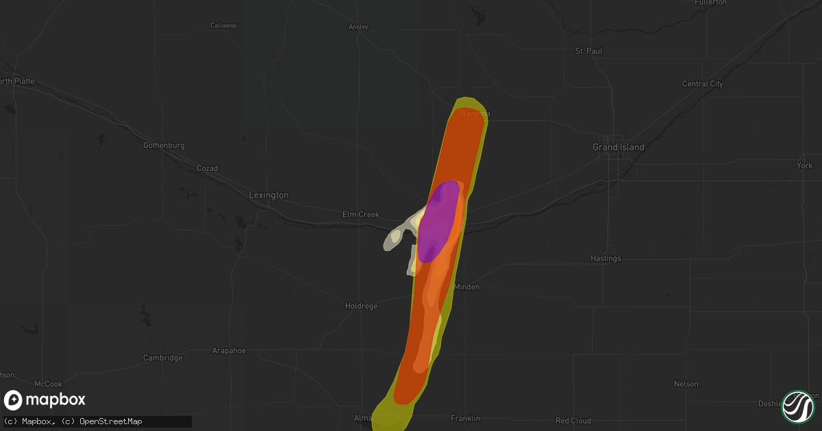
Hail Map in Kearney, NE on May 27, 2019
Get this storm
May 27 map
$229
one time, instant access
Download today. No call, no setup
Keep the $229
Bought the map and want the full workflow? Apply the entire $229 to a subscription within 7 days. None of it is wasted.
Every map, not just this one
This buys you this map. Subscription and you get every map we run, in the markets you choose from a few cities to whole states to nationwide. Plus real-time alerts the moment a storm fires.
Contact data
Name, contact info, occupancy, even credit band for addresses in the footprint. You go from where it hit to who to call.
Become the source they trust
Unlimited branding weather history reports on demand. You already have the documented answer ready for the property owner, and you are the one who showed up with it.
Property data and RoofTrace estimates
Pull up any address you have got, its value and the exact code rules for that jurisdiction, straight from One Click Code. Then RoofTrace estimates the squares, pitch, and roof value, priced the way you price.
Storm reports in Kearney, NE
Kearney, NE
| Date | Description |
|---|---|
| 05/27/201910:04 AM CDT | A few to ping pong ball size... But most smaller. |
| 05/26/201910:05 PM CDT | A local report indicates 1.00 inch wind near 1 N KEARNEY |
| 05/26/201910:02 PM CDT | A local report indicates 1.00 inch wind near 1 WSW KEARNEY |
| 05/26/201910:00 PM CDT | Via facebook photo. |
| 05/26/20199:59 PM CDT | Corrected from estimated to measured. |
All States Impacted by Hail Map on May 27, 2019
All Cities Impacted by Hail Map on May 27, 2019
- Willow Island, NE
- Gothenburg, NE
- Cozad, NE
- Unadilla, NE
- Palmyra, NE
- Eagle, NE
- Elmwood, NE
- Eckley, CO
- Callaway, NE
- Steger, IL
- Chicago Heights, IL
- Park Forest, IL
- Holyoke, CO
- Wray, CO
- Arapahoe, NE
- Elwood, NE
- Arcanum, OH
- Greenville, OH
- Scotia, NE
- Greeley, NE
- Iliff, CO
- Logansport, IN
- Walton, IN
- Galveston, IN
- Imperial, NE
- Hayes Center, NE
- Palisade, NE
- Champion, NE
- Enders, NE
- Wauneta, NE
- Oxford, IN
- Otterbein, IN
- West Lafayette, IN
- Boswell, IN
- Fowler, IN
- Milford, IL
- Ambia, IN
- Cissna Park, IL
- Wellington, IL
- Templeton, IN
- Burlington Junction, MO
- Elmo, MO
- Clearmont, MO
- Yuma, CO
- Haxtun, CO
- Brule, NE
- Big Springs, NE
- Rockville, NE
- Haigler, NE
- Wellfleet, NE
- Boelus, NE
- Hazard, NE
- Benkelman, NE
- Ravenna, NE
- Amherst, NE
- Brady, NE
- Farnam, NE
- Madrid, NE
- Eustis, NE
- Moorefield, NE
- Grant, NE
- Lexington, NE
- Miller, NE
- Stockville, NE
- Maywood, NE
- Cairo, NE
- Sumner, NE
- Eddyville, NE
- Wallace, NE
- Saint Paul, NE
- Pleasanton, NE
- Dickens, NE
- Saint Libory, NE
- Maxwell, NE
- Vernon, CO
- Elsie, NE
- Dannebrog, NE
- Parks, NE
- North Platte, NE
- Otis, CO
- Curtis, NE
- Yutan, NE
- Carter Lake, IA
- Council Bluffs, IA
- Ashland, NE
- Elkhorn, NE
- Gretna, NE
- Waterloo, NE
- Omaha, NE
- Boys Town, NE
- Denver, CO
- Commerce City, CO
- Brighton, CO
- Aurora, CO
- Englewood, CO
- Nodaway, IA
- Gravity, IA
- Lenox, IA
- Corning, IA
- North Loup, NE
- Culbertson, NE
- Beatrice, NE
- Delphi, IN
- Burnettsville, IN
- Royal Center, IN
- Idaville, IN
- Monticello, IN
- Hammond, IN
- Chicago, IL
- Whiting, IN
- Rochester, IN
- Kewanna, IN
- Winamac, IN
- Valparaiso, NE
- Wahoo, NE
- Ceresco, NE
- Weston, NE
- Arnold, NE
- Stapleton, NE
- La Fontaine, IN
- Adams, NE
- Filley, NE
- Pickrell, NE
- Kearney, NE
- Chicago Ridge, IL
- Palos Hills, IL
- Crest Hill, IL
- Palos Heights, IL
- Montgomery, IL
- Woodridge, IL
- Bolingbrook, IL
- Somonauk, IL
- Newark, IL
- Joliet, IL
- Plano, IL
- Lemont, IL
- Hickory Hills, IL
- Yorkville, IL
- Lockport, IL
- Bristol, IL
- Romeoville, IL
- Willow Springs, IL
- Naperville, IL
- Bridgeview, IL
- Worth, IL
- Oswego, IL
- Palos Park, IL
- Millbrook, IL
- Sheridan, IL
- Oak Lawn, IL
- Plainfield, IL
- Aurora, IL
- Alsip, IL
- Sandwich, IL
- Leland, IL
- Evergreen Park, IL
- East Chicago, IN
- Burr Oak, KS
- Republic, KS
- Hardy, NE
- Courtland, KS
- Byron, NE
- Webber, KS
- Mankato, KS
- Fairmont, NE
- McCool Junction, NE
- Tecumseh, NE
- Essex, IA
- Clarinda, IA
- Princeton, MO
- Remington, IN
- Wolcott, IN
- Brookston, IN
- Chalmers, IN
- Bartley, NE
- Indianola, NE
- Gibbon, NE
- Walkerton, IN
- Union Mills, IN
- Kingsford Heights, IN
- Hanna, IN
- Wanatah, IN
- Hamlet, IN
- La Porte, IN
- Hershey, NE
- Venango, NE
- Ovid, CO
- Julesburg, CO
- Crook, CO
- Sutherland, NE
- Paxton, NE
- Ogallala, NE
- Chappell, NE
- Sedgwick, CO
- Lodgepole, NE
- Galeton, CO
- Eaton, CO
- Gill, CO
- Lewisburg, OH
- Phillipsburg, KS
- Stockland, IL
- Axtell, NE
- Anderson, IN
- Pendleton, IN
- Waco, NE
- York, NE
- Weldona, CO
- Fort Morgan, CO
- Wiggins, CO
- Cedarville, OH
- Westboro, MO
- Daykin, NE
- Plymouth, NE
- Nemaha, NE
- Brownville, NE
- Peru, NE
- Crab Orchard, NE
- De Witt, NE
- Cortland, NE
- Jansen, NE
- Clatonia, NE
- Wilber, NE
- Watson, MO
- Sterling, NE
- Fairbury, NE
- Rock Port, MO
- Auburn, NE
- Western, NE
- Johnson, NE
- Hallam, NE
- Tarkio, MO
- Brock, NE
- Swanton, NE
- Griffith, IN
- Gary, IN
- Cullom, IL
- Nunn, CO
- Carr, CO
- Amboy, IL
- Harmon, IL
- Hastings, NE
- Plainville, KS
- Noblesville, IN
- Marion, IN
- Van Buren, IN
- Warren, IN
- Montpelier, IN
- McCook, NE
- Albion, NE
- Cedar Rapids, NE
- Primrose, NE
- Wolbach, NE
- Ord, NE
- Loup City, NE
- Saint Edward, NE
- Ashton, NE
- Spalding, NE
- Naponee, NE
- Republican City, NE
- Troy, OH
- West Milton, OH
- Tipp City, OH
- Lisle, IL
- Downers Grove, IL
- Glade, KS
- Stockton, KS
- Archer, NE
- Palmer, NE
- Clarks, NE
- Central City, NE
- Sterling, CO
- Woodston, KS
- Amherst, CO
- Fort Lupton, CO
- Lincoln, NE
- Minden, NE
- Pimento, IN
- Farmersburg, IN
- Marshall, IL
- West Union, IL
- Terre Haute, IN
- Martinsville, IL
- Yellow Springs, OH
- Jeffersonville, OH
- Fairborn, OH
- Xenia, OH
- Jamestown, OH
- South Solon, OH
- Dayton, OH
- Hawk Springs, WY
- Riverdale, NE
- Diagonal, IA
- Economy, IN
- Greens Fork, IN
- Williamsburg, IN
- Hagerstown, IN
- Valparaiso, IN
- Mitchell, NE
- Scottsbluff, NE
- Minatare, NE
- Gaylord, KS
- Tobias, NE
- Orland Park, IL
- Avoca, NE
- Merino, CO
- Dunbar, NE
- Otoe, NE
- Syracuse, NE
- Palco, KS
- Alton, KS
- Natoma, KS
- Osborne, KS
- Ellis, KS
- Funk, NE
- Portage, IN
- Hobart, IN
- Superior, NE
- Burns, WY
- Albin, WY
- La Salle, CO
- West Manchester, OH
- Brookville, OH
- Wilberforce, OH
- Fountain City, IN
- New Paris, OH
- Washington Court House, OH
- Verona, OH
- London, OH
- South Charleston, OH
- Eaton, OH
- Englewood, OH
- Clayton, OH
- Eldorado, OH
- Richmond, IN
- Lynn, IN
- Modoc, IN
- New Madison, OH
- Andrews, IN
- Wabash, IN
- Huntington, IN
- New Holland, OH
- Bloomingburg, OH
- Mount Sterling, OH
- Ashville, OH
- Circleville, OH
- Orient, OH
- Williamsport, OH
- Richton Park, IL
- Argos, IN
- Tippecanoe, IN
- River Forest, IL
- Crete, IL
- Doniphan, NE
- Grand Island, NE
- Phillips, NE
- Tinley Park, IL
- Arvada, CO
- Broken Bow, NE
- Westerville, NE
- Padroni, CO
- Comstock, NE
- Sargent, NE
- Merna, NE
- Ansley, NE
- Anselmo, NE
- Ithaca, NE
- Converse, IN
- Wilcox, NE
- Davenport, NE
- Greeley, CO
- Briggsdale, CO
- Sutton, NE
- Platteville, CO
- Hudson, CO
- Albany, IN
- Eaton, IN
- Muncie, IN
- Crescent, IA
- Honey Creek, IA
- Chesterton, IN
- Camden, IN
- Bunker Hill, IN
- Peru, IN
- Overton, NE
- Gering, NE
- Lyman, NE
- Ohiowa, NE
- Milligan, NE
- Alexandria, NE
- Friend, NE
- Saratoga, IN
- Union City, IN
- Winchester, IN
- Portis, KS
- Downs, KS
- Esbon, KS
- Homer Glen, IL
- Millington, IL
- Blue Island, IL
- Oak Forest, IL
- Willowbrook, IL
- Riverdale, IL
- Midlothian, IL
- Crestwood, IL
- Rock Falls, IL
- West Brooklyn, IL
- Deer Grove, IL
- Sublette, IL
- Cheyenne, WY
- Hillsdale, WY
- Akron, CO
- Shickley, NE
- Carleton, NE
- Bruning, NE
- Strang, NE
- Shenandoah, IA
- Hubbell, NE
- Hebron, NE
- Gilead, NE
- Henderson, NE
- Juniata, NE
- Prophetstown, IL
- Tampico, IL
- Silver Creek, NE
- Dyer, IN
- University Park, IL
- Munster, IN
- Matteson, IL
- Glenwood, IL
- Bolckow, MO
- Bennett, CO
- Hildreth, NE
- Hampton, NE
- Littleton, CO
- Lagrange, WY
- Oak, NE
- Edgar, NE
- Ong, NE
- Star City, IN
- Sugar Grove, IL
- North Aurora, IL
- Nehawka, NE
- Fishers, IN
- Westfield, IN
- Fortville, IN
- Ingalls, IN
- Lapel, IN
- Carmel, IN
- Lansing, IL
- Laurelville, OH
- Kingston, OH
- Vandalia, OH
- Ludlow Falls, OH
- Laura, OH
- Smith Center, KS
- Markleville, IN
- Mulberry, IN
- Rossville, IN
- Watkins, CO
- Monee, IL
- Schererville, IN
- Highland, IN
- Olympia Fields, IL
- Randolph, IA
- Bennington, NE
- Valley, NE
- Kennard, NE
- Broadview, IL
- Maywood, IL
- Westchester, IL
- Bellwood, IL
- Pontiac, IL
- Beaver Crossing, NE
- Mill Creek, IN
- Rolling Prairie, IN
- New Carlisle, IN
- Raymond, NE
- Martinsville, MO
- Bethany, MO
- Ridgeway, MO
- New Hampton, MO
- Albany, MO
- Arcadia, NE
- Cainsville, MO
- Dunkirk, IN
- Redkey, IN
- Powersville, MO
- Merrillville, IN
- Michigan City, IN
- Lake Station, IN
- Homewood, IL
- Westville, IN
- Thornton, IL
- Elk Creek, NE
- Humboldt, NE
- Sidney, IA
- Meriden, WY
- Grissom Arb, IN
- Miami, IN
- Chatsworth, IL
- Roberts, IL
- Carpenter, WY
- Percival, IA
- Nebraska City, NE
- Mercer, MO
- Shelton, NE
- Coin, IA
- Yorktown, IA
- Farragut, IA
- Bedford, IA
- New Market, IA
- Imogene, IA
- Villisca, IA
- Clearfield, IA
- Sharpsburg, IA
- Union, NE
- Tabor, IA
- Thurman, IA
- Giltner, NE
- Winfield, IL
- Casey, IL
- Middletown, IN
- Mooreland, IN
- Losantville, IN
- Springport, IN
- Daleville, IN
- New Castle, IN
- Union City, OH
- Portland, IN
- Ridgeville, IN
- Fleming, CO
- Pine Village, IN
- Bayard, NE
- Strawn, IL
- Buckley, IL
- Sibley, IL
- Onarga, IL
- Thawville, IL
- Melvin, IL
- Benton, IA
- Keenesburg, CO
- Indianapolis, IN
- Mccordsville, IN
- Greenfield, IN
- Aurora, NE
- Weeping Water, NE
- Oconto, NE
- Elm Creek, NE
- Harvard, NE
- Trumbull, NE
- Lucerne, MO
- Amboy, IN
- Oak Brook, IL
- Ashkum, IL
- Bellevue, NE
- Plattsmouth, NE
- Crown Point, IN
- Saint John, IN
- Hebron, IN
- South Bend, IN
- Frankfort, IL
- Pine Bluffs, WY
- Lafayette, IN
- Kempton, IL
- Saronville, NE
- Pawnee City, NE
- Axtell, KS
- Baileyville, KS
- Hawthorne, FL
- Citra, FL
- Harvey, IL
- Country Club Hills, IL
- Mokena, IL
- Posen, IL
- Hazel Crest, IL
- Robbins, IL
- Dolton, IL
- Calumet City, IL
- Hometown, IL
- Markham, IL
- South Holland, IL
- Nelson, NE
- Ruskin, NE
- Toulon, IL
- Princeville, IL
- Laura, IL
- Speer, IL
- Wyoming, IL
- Exeter, NE
- Deshler, NE
- Chester, NE
- Lewis, IN
- Battle Ground, IN
- Atlanta, IN
- Arcadia, IN
- Tipton, IN
- Cicero, IN
- Frankfort, IN
- Selma, IN
- Grover, CO
- Kersey, CO
- Roggen, CO
- Strasburg, CO
- Fe Warren Afb, WY
- Phillipsburg, OH
- Tryon, NE
- Keystone, NE
- Alma, NE
- Cook, NE
- Treynor, IA
- McClelland, IA
- Minden, IA
- New Carlisle, OH


