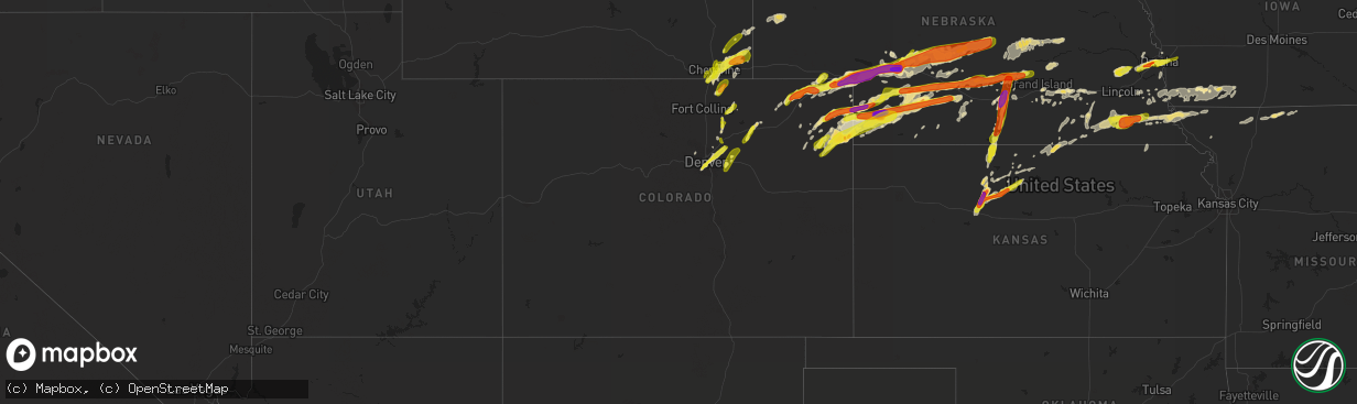
Hail Map in Colorado on May 27, 2019
The weather event in Colorado on May 27, 2019 includes Hail and Wind maps. 10 states and 613 cities were impacted and suffered possible damage. The total estimated number of properties impacted is 70,779.
Want more than just the map?
Turn this storm into a full workflow.
- Owner + property data so you know who to knock
- OnDemand branded weather history reports to win the "did we even have hail?" argument
- RoofTrace estimate so reps stop guessing numbers at the door
Bought this map? Upgrade within 7 days and we'll credit the $230. (10-15 min setup call)
Hail
Wind
70,779
Estimated number of impacted properties by a 1.00" hail or larger2,806
Estimated number of impacted properties by a 1.75" hail or larger245
Estimated number of impacted properties by a 2.50" hail or largerStorm reports in Colorado
Colorado
| Date | Description |
|---|---|
| 05/27/20196:58 PM CDT | A local report indicates 1.00 inch wind near 10 S PAOLI |
| 05/27/20196:53 PM CDT | Not fully condensed... But clear circulation at all levels beneath base with multiple ground circulations. Lasted one minute. |
| 05/27/20196:53 PM CDT | A local report indicates 1.00 inch wind near 5 NE CLARKVILLE |
| 05/27/20196:51 PM CDT | Brief touchdown of a weak tornado near the phillips and yuma county line. No damage reported. |
| 05/27/20196:50 PM CDT | Up to half dollar sized hail reported. Pasture grasses blown down. Via facebook. |
| 05/27/20196:40 PM CDT | A local report indicates 1.00 inch wind near CLARKVILLE |
| 05/27/20196:33 PM CDT | Footage of tornado from a storm chaser northeast of yuma. |
| 05/27/20196:29 PM CDT | Delayed report. Photo of tornado via twitter. |
| 05/27/20196:27 PM CDT | A local report indicates 1.00 inch wind near 2 NE GARDEN CITY |
| 05/27/20196:25 PM CDT | Spotter reported tornado 2 miles south of clarkville. Brief weak touchdowns under rotating wall cloud. |
| 05/27/20196:25 PM CDT | A local report indicates 1.00 inch wind near JULESBURG |
| 05/27/20196:11 PM CDT | Torrential rain. |
| 05/27/20196:05 PM CDT | Brief weak tornado. |
| 05/27/20195:58 PM CDT | Weak tornado lasted approximately 5 minutes in open space to the south and southeast of lochbuie. No damage reported. |
| 05/27/20195:57 PM CDT | A local report indicates 1.00 inch wind near 4 N LOCHBUIE |
| 05/27/20195:45 PM CDT | Damage to grain bins consistent with a tornado rated ef-0. 10 of 12 20...000 bushel grain bins were damaged... Some from downed pipes that fell onto them. Further south |
| 05/27/20195:42 PM CDT | A local report indicates 1.00 inch wind near CROOK |
| 05/27/20195:36 PM CDT | Brief weak tornado. No damage reported. |
| 05/27/20195:13 PM CDT | Hail accumulating to 3 inched deep in town. Minor localized flooding of streets and fields. Significant damage to vegetation in and around iliff. |
| 05/27/20194:34 PM CDT | A local report indicates 1.00 inch wind near 4 N LOGAN CORNERS |
| 05/27/20194:23 PM CDT | Brief needle tornado in open space. No damage reported. |
| 05/27/20194:03 PM CDT | Brief touchdown for less than one minute in an open field. No damage reported. |
| 05/27/20193:42 PM CDT | A local report indicates 1.25 inch wind near WIGGINS |
| 05/27/20193:37 PM CDT | A local report indicates 59 MPH wind near 1 NW FORT MORGAN |
| 05/27/20193:35 PM CDT | Hail ranging in size from peas to quarters measured 3 inches deep in the town of wiggins. |
| 05/27/20193:24 PM CDT | A local report indicates 1.00 inch wind near 4 NE WIGGINS |
| 05/27/20192:52 PM CDT | A local report indicates 1.00 inch wind near 11 N STRASBURG |
| 05/27/20192:43 PM CDT | Weak tornado with a brief touchdown in an open field. No damage reported. |
| 05/27/20192:13 PM CDT | Report via twitter. |
| 05/27/20192:00 PM CDT | A local report indicates 1.00 inch wind near 4 E WATKINS |
| 05/27/20197:50 AM CDT | At 1249 PM MDT, a severe thunderstorm was located near Watkins, or 22 miles east of Denver, moving northeast at 20 mph. HAZARD...60 mph wind gusts and quarter size hail. SOURCE...Radar indicated. IMPACT...Expect damage to roofs, siding, and trees. Hail damage to vehicles is expected. Locations impacted include... Northeastern Aurora, Bennett, Watkins and Manila Village. |
| 05/27/20192:52 AM CDT | A local report indicates 1.00 inch wind near 1 W DENVER INTL AIRPORT |
| 05/27/20192:20 AM CDT | A local report indicates 1.25 inch wind near 3 NE ENGLEWOOD |
| 05/27/20191:42 AM CDT | At 642 PM MDT, a severe thunderstorm was located 12 miles south of Yuma, moving northeast at 25 mph. HAZARD...60 mph wind gusts and quarter size hail. SOURCE...Radar indicated. IMPACT...Hail damage to vehicles is expected. Expect wind damage to roofs, siding, and trees. Locations impacted include... Yuma, Wray, Eckley, Abarr, Heartstrong and Vernon. This includes Highway 385 between mile markers 244 and 245. |
| 05/27/201912:40 AM CDT | At 539 PM MDT, a severe thunderstorm was located near Big Springs, moving northeast at 35 mph. HAZARD...Tennis ball size hail and 60 mph wind gusts. SOURCE...Radar indicated. IMPACT...People and animals outdoors will be injured. Expect hail damage to roofs, siding, windows, and vehicles. Expect wind damage to roofs, siding, and trees. Locations impacted include... Ogallala, Big Springs, Brule, Kingsley Dam, Wild Horse Spring and Megeath.This includes the following highways... Highway 61 between mile markers 70 and 99. Interstate 80 in Nebraska between mile markers 107 and 131. |
| 05/27/201912:40 AM CDT | At 540 PM MDT, a severe thunderstorm was located 6 miles south of Highland Center, or 16 miles southwest of Holyoke, moving northeast at 25 mph. HAZARD...60 mph wind gusts and half dollar size hail. SOURCE...Radar indicated. IMPACT...Expect damage to roofs, siding, and trees. Hail damage to vehicles is expected. Locations impacted include... Holyoke, Paoli and Highland Center. |
| 05/27/201912:12 AM CDT | At 511 PM MDT, a severe thunderstorm was located over Ovid, or near Julesburg, moving northeast at 30 mph. HAZARD...Ping pong ball size hail and 60 mph wind gusts. SOURCE...Radar indicated. IMPACT...People and animals outdoors will be injured. Expect hail damage to roofs, siding, windows, and vehicles. Expect wind damage to roofs, siding, and trees. Locations impacted include... Chappell, Big Springs, Barton and Goldeneye State Wildlife Management Area.This includes Interstate 80 in Nebraska between mile markers 82 and108. |
| 05/27/201912:10 AM CDT | Public reported via facebook 2 inch hail 3 miles e and 2 miles south of wray... Co. They also reported broken tree branches... But no thickness was given of the branche |
| 05/27/201912:04 AM CDT | At 503 PM MDT, a severe thunderstorm was located 6 miles southeast of Lone Star, or 12 miles north of Yuma, moving northeast at 35 mph. HAZARD...60 mph wind gusts and quarter size hail. SOURCE...Radar indicated. IMPACT...Hail damage to vehicles is expected. Expect wind damage to roofs, siding, and trees. Locations impacted include... Clarkville. |
| 05/27/201912:00 AM CDT | Public reported 2 inch hail 2 miles e of wray... Co. |
| 05/27/201912:00 AM CDT | Public reported via facebook 2 inch hail at county road cc & 37 |
| 05/26/201911:58 PM CDT | At 458 PM MDT, severe thunderstorms were located along a line extending from 6 miles north of Purcell to near Milton Reservoir, or along a line extending from 26 miles northeast of Fort Collins to 16 miles southeast of Greeley, moving northeast at 15 mph. HAZARD...Quarter size hail. SOURCE...Radar indicated. IMPACT...Damage to vehicles is expected. Locations impacted include... Southeastern Greeley, Evans, LaSalle, Kersey, Purcell, Galeton, Gill, Milton Reservoir, Barnesville and Briggsdale. |
| 05/26/201911:30 PM CDT | A local report indicates 1.00 inch wind near YUMA |
| 05/26/201910:40 PM CDT | At 340 PM MDT, a severe thunderstorm was located 5 miles northeast of Nunn, or 23 miles northeast of Fort Collins, moving northeast at 20 mph. HAZARD...Quarter size hail. SOURCE...Radar indicated. IMPACT...Damage to vehicles is expected. Locations impacted include... Rockport. |
| 05/26/201910:27 PM CDT | At 326 PM MDT, severe thunderstorms were located along a line extending from 8 miles northwest of Hillsdale to 7 miles southeast of South Greeley, moving northeast at 30 mph. HAZARD...60 mph wind gusts and quarter size hail. SOURCE...Radar indicated. IMPACT...Hail damage to vehicles is expected. Expect wind damage to roofs, siding, and trees. Locations impacted include... Burns, Hillsdale, Gun Barrel, Ranchettes and Fox Farm-College.This includes Interstate 80 in Wyoming between mile markers 364 and389.This replaces the Severe Thunderstorm Warning which was previously in effect for the warned rea. |
| 05/26/20199:43 PM CDT | At 239 PM MDT, a cluster of severe thunderstorms was located over south central Laramie County including the city of Cheyenne, moving north at 15 MPH. HAZARD...Quarter size hail. SOURCE...Radar indicated. IMPACT...Damage to vehicles is expected. Slick road conditions are likely due to hail accumulating on roadways. Use extreme caution if traveling. Locations impacted include... Cheyenne, South Greeley, Ranchettes, Warren AFB, Frontier Park, North Cheyenne, Whitaker, Warren Af Base, Fox Farm-College and South Greeley High.This includes the following highways... Interstate 25 in Wyoming between mile markers 1 and 32. Interstate 80 in Wyoming between mile markers 352 and 373. |
| 05/26/20199:41 PM CDT | At 241 PM MDT, a severe thunderstorm was located 5 miles northeast of Weldona, or 9 miles northwest of Fort Morgan, moving northeast at 35 mph. HAZARD...Half dollar size hail. SOURCE...Radar indicated. IMPACT...Damage to vehicles is expected. Hail may accumulate on roadways causing hazardous travel. Locations impacted include... Fort Morgan, Log Lane Village, New Raymer, Antelope Springs, Stoneham, Weldona, Pawnee Pass, Willard and Goodrich. |
| 05/26/20199:02 PM CDT | A local report indicates 1.00 inch wind near 4 NW ALVIN |
| 05/26/20199:00 PM CDT | At 200 PM MDT, a severe thunderstorm was located 5 miles southwest of Wiggins, or 18 miles southwest of Fort Morgan, moving north at 15 mph. HAZARD...70 mph wind gusts and ping pong ball size hail. SOURCE...Radar indicated. IMPACT...Expect considerable tree damage. Damage is likely to mobile homes, roofs, and outbuildings. People and animals outdoors will be injured. Expect hail damage to roofs, siding, windows, and vehicles. Locations impacted include... Wiggins, Jackson Reservoir, Orchard, Weldona and Goodrich. |
| 05/26/20198:28 PM CDT | At 127 PM MDT, a severe thunderstorm was located 6 miles north of Bennett, or 32 miles east of Denver, moving northeast at 30 mph. HAZARD...70 mph wind gusts and ping pong ball size hail. SOURCE...Radar indicated. IMPACT...Expect considerable tree damage. Damage is likely to mobile homes, roofs, and outbuildings. People and animals outdoors will be injured. Expect hail damage to roofs, siding, windows, and vehicles. Locations impacted include... Bennett, Prospect Valley, Hoyt and Strasburg. |
| 05/26/20198:00 PM CDT | Quarter size hail reported 3 miles east and 2 miles south of yuma at 7 pm mdt. |
| 05/26/20197:32 PM CDT | Brief weak tornado in open country. No damage. |
| 05/26/20197:30 PM CDT | A local report indicates 2.50 inch wind near 12 SSE HOLYOKE |
| 05/26/20197:23 PM CDT | A local report indicates 1.75 inch wind near 8 ESE HOLYOKE |
| 05/26/20197:10 PM CDT | A local report indicates 1.00 inch wind near 12 S PLEASANT VALLEY |
All States Impacted by Hail Map on May 27, 2019
Cities Impacted by Hail Map on May 27, 2019
- Willow Island, NE
- Gothenburg, NE
- Cozad, NE
- Unadilla, NE
- Palmyra, NE
- Eagle, NE
- Elmwood, NE
- Eckley, CO
- Callaway, NE
- Steger, IL
- Chicago Heights, IL
- Park Forest, IL
- Holyoke, CO
- Wray, CO
- Arapahoe, NE
- Elwood, NE
- Arcanum, OH
- Greenville, OH
- Scotia, NE
- Greeley, NE
- Iliff, CO
- Logansport, IN
- Walton, IN
- Galveston, IN
- Imperial, NE
- Hayes Center, NE
- Palisade, NE
- Champion, NE
- Enders, NE
- Wauneta, NE
- Oxford, IN
- Otterbein, IN
- West Lafayette, IN
- Boswell, IN
- Fowler, IN
- Milford, IL
- Ambia, IN
- Cissna Park, IL
- Wellington, IL
- Templeton, IN
- Burlington Junction, MO
- Elmo, MO
- Clearmont, MO
- Yuma, CO
- Haxtun, CO
- Brule, NE
- Big Springs, NE
- Rockville, NE
- Haigler, NE
- Wellfleet, NE
- Boelus, NE
- Hazard, NE
- Benkelman, NE
- Ravenna, NE
- Amherst, NE
- Brady, NE
- Farnam, NE
- Madrid, NE
- Eustis, NE
- Moorefield, NE
- Grant, NE
- Lexington, NE
- Miller, NE
- Stockville, NE
- Maywood, NE
- Cairo, NE
- Sumner, NE
- Eddyville, NE
- Wallace, NE
- Saint Paul, NE
- Pleasanton, NE
- Dickens, NE
- Saint Libory, NE
- Maxwell, NE
- Vernon, CO
- Elsie, NE
- Dannebrog, NE
- Parks, NE
- North Platte, NE
- Otis, CO
- Curtis, NE
- Yutan, NE
- Carter Lake, IA
- Council Bluffs, IA
- Ashland, NE
- Elkhorn, NE
- Gretna, NE
- Waterloo, NE
- Omaha, NE
- Boys Town, NE
- Denver, CO
- Commerce City, CO
- Brighton, CO
- Aurora, CO
- Englewood, CO
- Nodaway, IA
- Gravity, IA
- Lenox, IA
- Corning, IA
- North Loup, NE
- Culbertson, NE
- Beatrice, NE
- Delphi, IN
- Burnettsville, IN
- Royal Center, IN
- Idaville, IN
- Monticello, IN
- Hammond, IN
- Chicago, IL
- Whiting, IN
- Rochester, IN
- Kewanna, IN
- Winamac, IN
- Valparaiso, NE
- Wahoo, NE
- Ceresco, NE
- Weston, NE
- Arnold, NE
- Stapleton, NE
- La Fontaine, IN
- Adams, NE
- Filley, NE
- Pickrell, NE
- Kearney, NE
- Chicago Ridge, IL
- Palos Hills, IL
- Crest Hill, IL
- Palos Heights, IL
- Montgomery, IL
- Woodridge, IL
- Bolingbrook, IL
- Somonauk, IL
- Newark, IL
- Joliet, IL
- Plano, IL
- Lemont, IL
- Hickory Hills, IL
- Yorkville, IL
- Lockport, IL
- Bristol, IL
- Romeoville, IL
- Willow Springs, IL
- Naperville, IL
- Bridgeview, IL
- Worth, IL
- Oswego, IL
- Palos Park, IL
- Millbrook, IL
- Sheridan, IL
- Oak Lawn, IL
- Plainfield, IL
- Aurora, IL
- Alsip, IL
- Sandwich, IL
- Leland, IL
- Evergreen Park, IL
- East Chicago, IN
- Burr Oak, KS
- Republic, KS
- Hardy, NE
- Courtland, KS
- Byron, NE
- Webber, KS
- Mankato, KS
- Fairmont, NE
- McCool Junction, NE
- Tecumseh, NE
- Essex, IA
- Clarinda, IA
- Princeton, MO
- Remington, IN
- Wolcott, IN
- Brookston, IN
- Chalmers, IN
- Bartley, NE
- Indianola, NE
- Gibbon, NE
- Walkerton, IN
- Union Mills, IN
- Kingsford Heights, IN
- Hanna, IN
- Wanatah, IN
- Hamlet, IN
- La Porte, IN
- Hershey, NE
- Venango, NE
- Ovid, CO
- Julesburg, CO
- Crook, CO
- Sutherland, NE
- Paxton, NE
- Ogallala, NE
- Chappell, NE
- Sedgwick, CO
- Lodgepole, NE
- Galeton, CO
- Eaton, CO
- Gill, CO
- Lewisburg, OH
- Phillipsburg, KS
- Stockland, IL
- Axtell, NE
- Anderson, IN
- Pendleton, IN
- Waco, NE
- York, NE
- Weldona, CO
- Fort Morgan, CO
- Wiggins, CO
- Cedarville, OH
- Westboro, MO
- Daykin, NE
- Plymouth, NE
- Nemaha, NE
- Brownville, NE
- Peru, NE
- Crab Orchard, NE
- De Witt, NE
- Cortland, NE
- Jansen, NE
- Clatonia, NE
- Wilber, NE
- Watson, MO
- Sterling, NE
- Fairbury, NE
- Rock Port, MO
- Auburn, NE
- Western, NE
- Johnson, NE
- Hallam, NE
- Tarkio, MO
- Brock, NE
- Swanton, NE
- Griffith, IN
- Gary, IN
- Cullom, IL
- Nunn, CO
- Carr, CO
- Amboy, IL
- Harmon, IL
- Hastings, NE
- Plainville, KS
- Noblesville, IN
- Marion, IN
- Van Buren, IN
- Warren, IN
- Montpelier, IN
- McCook, NE
- Albion, NE
- Cedar Rapids, NE
- Primrose, NE
- Wolbach, NE
- Ord, NE
- Loup City, NE
- Saint Edward, NE
- Ashton, NE
- Spalding, NE
- Naponee, NE
- Republican City, NE
- Troy, OH
- West Milton, OH
- Tipp City, OH
- Lisle, IL
- Downers Grove, IL
- Glade, KS
- Stockton, KS
- Archer, NE
- Palmer, NE
- Clarks, NE
- Central City, NE
- Sterling, CO
- Woodston, KS
- Amherst, CO
- Fort Lupton, CO
- Lincoln, NE
- Minden, NE
- Pimento, IN
- Farmersburg, IN
- Marshall, IL
- West Union, IL
- Terre Haute, IN
- Martinsville, IL
- Yellow Springs, OH
- Jeffersonville, OH
- Fairborn, OH
- Xenia, OH
- Jamestown, OH
- South Solon, OH
- Dayton, OH
- Hawk Springs, WY
- Riverdale, NE
- Diagonal, IA
- Economy, IN
- Greens Fork, IN
- Williamsburg, IN
- Hagerstown, IN
- Valparaiso, IN
- Mitchell, NE
- Scottsbluff, NE
- Minatare, NE
- Gaylord, KS
- Tobias, NE
- Orland Park, IL
- Avoca, NE
- Merino, CO
- Dunbar, NE
- Otoe, NE
- Syracuse, NE
- Palco, KS
- Alton, KS
- Natoma, KS
- Osborne, KS
- Ellis, KS
- Funk, NE
- Portage, IN
- Hobart, IN
- Superior, NE
- Burns, WY
- Albin, WY
- La Salle, CO
- West Manchester, OH
- Brookville, OH
- Wilberforce, OH
- Fountain City, IN
- New Paris, OH
- Washington Court House, OH
- Verona, OH
- London, OH
- South Charleston, OH
- Eaton, OH
- Englewood, OH
- Clayton, OH
- Eldorado, OH
- Richmond, IN
- Lynn, IN
- Modoc, IN
- New Madison, OH
- Andrews, IN
- Wabash, IN
- Huntington, IN
- New Holland, OH
- Bloomingburg, OH
- Mount Sterling, OH
- Ashville, OH
- Circleville, OH
- Orient, OH
- Williamsport, OH
- Richton Park, IL
- Argos, IN
- Tippecanoe, IN
- River Forest, IL
- Crete, IL
- Doniphan, NE
- Grand Island, NE
- Phillips, NE
- Tinley Park, IL
- Arvada, CO
- Broken Bow, NE
- Westerville, NE
- Padroni, CO
- Comstock, NE
- Sargent, NE
- Merna, NE
- Ansley, NE
- Anselmo, NE
- Ithaca, NE
- Converse, IN
- Wilcox, NE
- Davenport, NE
- Greeley, CO
- Briggsdale, CO
- Sutton, NE
- Platteville, CO
- Hudson, CO
- Albany, IN
- Eaton, IN
- Muncie, IN
- Crescent, IA
- Honey Creek, IA
- Chesterton, IN
- Camden, IN
- Bunker Hill, IN
- Peru, IN
- Overton, NE
- Gering, NE
- Lyman, NE
- Ohiowa, NE
- Milligan, NE
- Alexandria, NE
- Friend, NE
- Saratoga, IN
- Union City, IN
- Winchester, IN
- Portis, KS
- Downs, KS
- Esbon, KS
- Homer Glen, IL
- Millington, IL
- Blue Island, IL
- Oak Forest, IL
- Willowbrook, IL
- Riverdale, IL
- Midlothian, IL
- Crestwood, IL
- Rock Falls, IL
- West Brooklyn, IL
- Deer Grove, IL
- Sublette, IL
- Cheyenne, WY
- Hillsdale, WY
- Akron, CO
- Shickley, NE
- Carleton, NE
- Bruning, NE
- Strang, NE
- Shenandoah, IA
- Hubbell, NE
- Hebron, NE
- Gilead, NE
- Henderson, NE
- Juniata, NE
- Prophetstown, IL
- Tampico, IL
- Silver Creek, NE
- Dyer, IN
- University Park, IL
- Munster, IN
- Matteson, IL
- Glenwood, IL
- Bolckow, MO
- Bennett, CO
- Hildreth, NE
- Hampton, NE
- Littleton, CO
- Lagrange, WY
- Oak, NE
- Edgar, NE
- Ong, NE
- Star City, IN
- Sugar Grove, IL
- North Aurora, IL
- Nehawka, NE
- Fishers, IN
- Westfield, IN
- Fortville, IN
- Ingalls, IN
- Lapel, IN
- Carmel, IN
- Lansing, IL
- Laurelville, OH
- Kingston, OH
- Vandalia, OH
- Ludlow Falls, OH
- Laura, OH
- Smith Center, KS
- Markleville, IN
- Mulberry, IN
- Rossville, IN
- Watkins, CO
- Monee, IL
- Schererville, IN
- Highland, IN
- Olympia Fields, IL
- Randolph, IA
- Bennington, NE
- Valley, NE
- Kennard, NE
- Broadview, IL
- Maywood, IL
- Westchester, IL
- Bellwood, IL
- Pontiac, IL
- Beaver Crossing, NE
- Mill Creek, IN
- Rolling Prairie, IN
- New Carlisle, IN
- Raymond, NE
- Martinsville, MO
- Bethany, MO
- Ridgeway, MO
- New Hampton, MO
- Albany, MO
- Arcadia, NE
- Cainsville, MO
- Dunkirk, IN
- Redkey, IN
- Powersville, MO
- Merrillville, IN
- Michigan City, IN
- Lake Station, IN
- Homewood, IL
- Westville, IN
- Thornton, IL
- Elk Creek, NE
- Humboldt, NE
- Sidney, IA
- Meriden, WY
- Grissom Arb, IN
- Miami, IN
- Chatsworth, IL
- Roberts, IL
- Carpenter, WY
- Percival, IA
- Nebraska City, NE
- Mercer, MO
- Shelton, NE
- Coin, IA
- Yorktown, IA
- Farragut, IA
- Bedford, IA
- New Market, IA
- Imogene, IA
- Villisca, IA
- Clearfield, IA
- Sharpsburg, IA
- Union, NE
- Tabor, IA
- Thurman, IA
- Giltner, NE
- Winfield, IL
- Casey, IL
- Middletown, IN
- Mooreland, IN
- Losantville, IN
- Springport, IN
- Daleville, IN
- New Castle, IN
- Union City, OH
- Portland, IN
- Ridgeville, IN
- Fleming, CO
- Pine Village, IN
- Bayard, NE
- Strawn, IL
- Buckley, IL
- Sibley, IL
- Onarga, IL
- Thawville, IL
- Melvin, IL
- Benton, IA
- Keenesburg, CO
- Indianapolis, IN
- Mccordsville, IN
- Greenfield, IN
- Aurora, NE
- Weeping Water, NE
- Oconto, NE
- Elm Creek, NE
- Harvard, NE
- Trumbull, NE
- Lucerne, MO
- Amboy, IN
- Oak Brook, IL
- Ashkum, IL
- Bellevue, NE
- Plattsmouth, NE
- Crown Point, IN
- Saint John, IN
- Hebron, IN
- South Bend, IN
- Frankfort, IL
- Pine Bluffs, WY
- Lafayette, IN
- Kempton, IL
- Saronville, NE
- Pawnee City, NE
- Axtell, KS
- Baileyville, KS
- Hawthorne, FL
- Citra, FL
- Harvey, IL
- Country Club Hills, IL
- Mokena, IL
- Posen, IL
- Hazel Crest, IL
- Robbins, IL
- Dolton, IL
- Calumet City, IL
- Hometown, IL
- Markham, IL
- South Holland, IL
- Nelson, NE
- Ruskin, NE
- Toulon, IL
- Princeville, IL
- Laura, IL
- Speer, IL
- Wyoming, IL
- Exeter, NE
- Deshler, NE
- Chester, NE
- Lewis, IN
- Battle Ground, IN
- Atlanta, IN
- Arcadia, IN
- Tipton, IN
- Cicero, IN
- Frankfort, IN
- Selma, IN
- Grover, CO
- Kersey, CO
- Roggen, CO
- Strasburg, CO
- Fe Warren Afb, WY
- Phillipsburg, OH
- Tryon, NE
- Keystone, NE
- Alma, NE
- Cook, NE
- Treynor, IA
- McClelland, IA
- Minden, IA
- New Carlisle, OH


