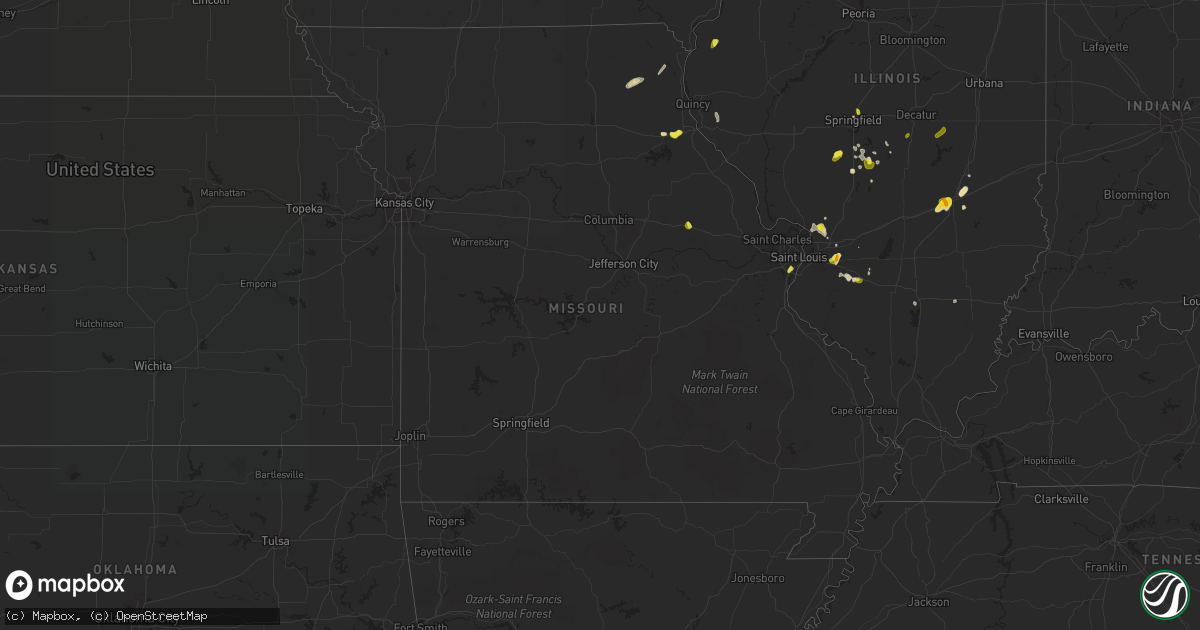
Hail Map in Missouri on May 27, 2018
Get this storm
May 27 map
$229
one time, instant access
Download today. No call, no setup
Keep the $229
Bought the map and want the full workflow? Apply the entire $229 to a subscription within 7 days. None of it is wasted.
Every map, not just this one
This buys you this map. Subscription and you get every map we run, in the markets you choose from a few cities to whole states to nationwide. Plus real-time alerts the moment a storm fires.
Contact data
Name, contact info, occupancy, even credit band for addresses in the footprint. You go from where it hit to who to call.
Become the source they trust
Unlimited branding weather history reports on demand. You already have the documented answer ready for the property owner, and you are the one who showed up with it.
Property data and RoofTrace estimates
Pull up any address you have got, its value and the exact code rules for that jurisdiction, straight from One Click Code. Then RoofTrace estimates the squares, pitch, and roof value, priced the way you price.
Storm reports in Missouri
Missouri
| Date | Description |
|---|---|
| 05/27/20185:53 PM CDT | Time estimated from radar. Facebook report. |
| 05/27/20185:51 PM CDT | Time estimated by radar. From wgem. |
| 05/27/20185:44 PM CDT | Spotter reported hail the size of quarters and dimes near elm and county road 267. |
| 05/27/20185:31 PM CDT | Employee traveling along i-70 reported 1.00 hail at mile marker 174. |
| 05/27/20185:29 PM CDT | A local report indicates 1.00 inch wind near 2 SE NEW FLORENCE |
| 05/27/20183:34 PM CDT | A local report indicates 1.00 inch wind near AFFTON |
| 05/27/20181:11 AM CDT | At 610 PM CDT, severe thunderstorms were located along a line extending from near Rosewood Heights to near Mascoutah, moving southwest at 15 mph. HAZARD...60 mph wind gusts and quarter size hail. SOURCE...Trained weather spotters. A 68 mph wind gust was reported at Alton regional airport. IMPACT...Hail damage to vehicles is expected. Expect wind damage to roofs, siding, and trees. Locations impacted include... St. Louis, Florissant, Belleville, University City, Granite City, O'Fallon, Alton, East St. Louis, Hazelwood, Collinsville, Ferguson, Godfrey, Fairview Heights, Cahokia, Jennings, Swansea, Shiloh, Bellefontaine Neighbors, Wood River and Berkeley.This includes Interstate 64 in Illinois between exits 9 and 12. This also includes Scott Joplin Historic Site, Confluence StatePark, and Horseshoe Lake State Park. |
| 05/27/201812:50 AM CDT | At 549 PM CDT, a severe thunderstorm was located over Rensselaer, moving southwest at 5 mph. HAZARD...60 mph wind gusts and quarter size hail. SOURCE...Trained weather spotters. IMPACT...Hail damage to vehicles is expected. Expect wind damage to roofs, siding, and trees. Locations impacted include... Monroe City, Rensselaer, Spaulding and The Landing. |
| 05/27/201812:46 AM CDT | At 546 PM CDT, a severe thunderstorm was located over La Belle, moving southwest at 5 mph. HAZARD...60 mph wind gusts and quarter size hail. SOURCE...Radar indicated. IMPACT...Hail damage to vehicles is expected. Expect wind damage to roofs, siding, and trees. Locations impacted include... Knox City, Plevna and Newark. |
| 05/27/201812:22 AM CDT | At 522 PM CDT, a severe thunderstorm was located over New Florence, and is nearly stationary. HAZARD...60 mph wind gusts and quarter size hail. SOURCE...Radar indicated. IMPACT...Hail damage to vehicles is expected. Expect wind damage to roofs, siding, and trees. Locations impacted include... Montgomery City, New Florence, Jonesburg, Bellflower, Mineola, Big Spring, High Hill and Danville.This includes Interstate 70 in Missouri between exits 170 and 183. This also includes Graham Cave State Park. |
| 05/26/201811:03 PM CDT | At 403 PM CDT, a severe thunderstorm was located near Payson, moving south at 10 mph. HAZARD...60 mph wind gusts and quarter size hail. SOURCE...Radar indicated. IMPACT...Hail damage to vehicles is expected. Expect wind damage to roofs, siding, and trees. Locations impacted include... Payson, Liberty, Hull, Richfield, New Canton, Plainville, Kinderhook and Seehorn.This includes Interstate 72 between exits 4 and 10. |
| 05/26/201810:28 PM CDT | At 328 PM CDT, a severe thunderstorm was located over Mehlville, and is nearly stationary. HAZARD...60 mph wind gusts and quarter size hail. SOURCE...Radar indicated. IMPACT...Hail damage to vehicles is expected. Expect wind damage to roofs, siding, and trees. Locations impacted include... St. Louis, Kirkwood, Webster Groves, Arnold, Crestwood, Sunset Hills, Maplewood, Valley Park, Shrewsbury, Glendale, Fenton, Lakeshire, Oakland, Barnhart, Affton, Murphy, Lemay, Mehlville, Oakville and Green Park.This includes the following highways... Interstate 44 in Missouri between exits 272 and 277. Interstate 55 in Missouri between exits 185 and 191.This also includes Mastodon Historic Site. |
| 05/26/20188:58 PM CDT | At 158 AM CDT, a severe thunderstorm was located over Maplewood, moving south at 20 mph. HAZARD...Quarter size hail. SOURCE...Radar indicated. IMPACT...Damage to vehicles is expected. Locations impacted include... St. Louis, University City, Kirkwood, East St. Louis, Webster Groves, Arnold, Creve Coeur, Overland, Clayton, Cahokia, Jennings, Crestwood, Bellefontaine Neighbors, Columbia, Richmond Heights, Ladue, Brentwood, Maplewood, Olivette and St. John.This also includes Scott Joplin Historic Site. |
All States Impacted by Hail Map on May 27, 2018
Cities Impacted by Hail Map on May 27, 2018
- Casper, WY
- Laramie, WY
- Buford, WY
- Ogallala, NE
- Saint Francis, KS
- Haxtun, CO
- Nokomis, IL
- Glenrock, WY
- Fort Morgan, CO
- New Raymer, CO
- Douglas, WY
- McDonald, KS
- Colby, KS
- Tribune, KS
- Ranchester, WY
- Sheridan, WY
- Bettendorf, IA
- East Moline, IL
- Le Claire, IA
- Saint Jacob, IL
- Snyder, CO
- Bethune, CO
- Burlington, CO
- Stratton, CO
- Idalia, CO
- Wray, CO
- Harrison, NE
- Leoti, KS
- Benkelman, NE
- Panhandle, TX
- Skellytown, TX
- Pampa, TX
- Brook, IN
- Paxton, NE
- Crawford, NE
- Evansville, WY
- Johnson, KS
- Elsie, NE
- Dieterich, IL
- Winner, SD
- Andover, SD
- Holyoke, CO
- Amherst, CO
- Kanorado, KS
- Effingham, IL
- Altamont, IL
- Cheyenne, WY
- Gruver, TX
- Stapleton, NE
- Morocco, IN
- Bethalto, IL
- Cottage Hills, IL
- East Alton, IL
- Yuma, CO
- Eckley, CO
- Knox City, MO
- Edina, MO
- Pine Ridge, SD
- Julesburg, CO
- Venango, NE
- Syracuse, KS
- Bartelso, IL
- Harvel, IL
- Morrisonville, IL
- Riverton, WY
- Lander, WY
- Winslow, IN
- Ulysses, KS
- Kendall, KS
- Lakin, KS
- Hot Springs, SD
- Springfield, IL
- Gering, NE
- Mission, SD
- Blunt, SD
- Mikado, MI
- Manson, IA
- Grant, NE
- Wauneta, NE
- Palisade, NE
- Saint Louis, MO
- Stockville, NE
- Vernon, CO
- Harrisville, MI
- Greenbush, MI
- Kirk, CO
- Akron, CO
- Groton, SD
- Saint Francis, SD
- Bennett, IA
- Wilton, IA
- Williams, MN
- Montrose, IL
- Teutopolis, IL
- Sigel, IL
- East Tawas, MI
- Watson, IL
- Tie Siding, WY
- Palmer, IL
- Taylorville, IL
- Brule, NE
- Clare, MI
- Atwood, KS
- Haigler, NE
- Tawas City, MI
- Buffalo Gap, SD
- Madrid, NE
- Imperial, NE
- Wood River, IL
- Fall Creek, WI
- Highland, IL
- Curtis, NE
- Moorefield, NE
- Farnam, NE
- Hayes Center, NE
- Mount Pleasant, MI
- Fort Washakie, WY
- Roggen, CO
- Wiggins, CO
- Conde, SD
- Sparrows Point, MD
- Dundalk, MD
- Fergus Falls, MN
- Alger, MI
- Sterling, MI
- Palmyra, MO
- Hannibal, MO
- Monroe City, MO
- Seibert, CO
- Waggoner, IL
- Sterling, CO
- Bird City, KS
- Edson, KS
- Vona, CO
- Lebanon, IL
- Whitney, NE
- Oelrichs, SD
- Oral, SD
- Edgemont, SD
- Elwood, NE
- Laurel, MT
- New Baden, IL
- Mascoutah, IL
- Liberty, IL
- Plainville, IL
- Wallace, NE
- Edwardsville, IL
- Centreville, MD
- Queenstown, MD
- Jeffrey City, WY
- Frederick, SD
- Stoneham, CO
- Bartley, NE
- Indianola, NE
- Virden, IL
- Auburn, IL
- Okawville, IL
- Addieville, IL
- Colfax, WI
- Chippewa Falls, WI
- Sugar City, CO
- Granite Canon, WY
- Onida, SD
- Scottsbluff, NE
- Hershey, NE
- Pawnee, IL
- Divernon, IL
- Champion, NE
- Keystone, NE
- Parks, NE
- Wall, SD
- Monticello, MO
- Williamstown, MO
- Saint Patrick, MO
- Wood, SD
- Hatley, WI
- Rosholt, WI
- Carthage, IL
- Goodland, KS
- Lemoyne, NE
- Maxwell, NE
- Lewellen, NE
- Winona, KS
- Roosevelt, MN
- Arapahoe, NE
- Moline, IL
- Anton, CO
- Lindon, CO
- La Belle, MO
- Baudette, MN
- Mitchell, NE
- Boyd, WI
- Levant, KS
- Ovid, CO
- Grover, CO
- Mosinee, WI
- New Liberty, IA
- Carlin, NV
- Brewster, KS
- New Florence, MO
- Velpen, IN
- Huntingburg, IN
- Raymond, IL
- Trenton, IL
- Roslyn, SD
- Elko, NV
- Marsland, NE
- O'Fallon, IL
- Otwell, IN
- Wanblee, SD
- Westport, PA
- Harrisburg, NE
- Moro, IL
- Worden, IL
- Dorsey, IL
- Trilla, IL
- Elwell, MI
- Riverdale, MI
- Roxana, IL
- Max, NE
- Stratton, NE
- Farmersville, IL
- De Witt, IA
- Farwell, MI
- Standish, MI
- Kentland, IN
- Goodland, IN
- Fairburn, SD
- Hermosa, SD
- Smithwick, SD
- Hampton, IL
- Port Byron, IL
- Rapids City, IL
- Manter, KS
- Hay Springs, NE
- Merino, CO
- Camanche, IA
- North Platte, NE
- Omer, MI
- Wheatland, WY
- Karval, CO
- Encampment, WY
- Waltonville, IL
- Mount Vernon, IL
- Howe, ID
- Coulterville, IL
- Kit Carson, CO
- Jim Falls, WI
- Pleasant Valley, IA
- Montgomery City, MO
- Big Springs, NE
- Atwood, CO
- Sidney, NE
- Arapahoe, WY
- Wayne City, IL
- Dahlgren, IL
- Bloomer, WI
- Hemingford, NE
- Cody, NE
- Tuthill, SD
- Pinconning, MI
- Bentley, MI
- Sherman, IL
- Bethany, IL
- Sullivan, IL
- Lovington, IL
- Moweaqua, IL
- Girard, IL
- Orchard, CO
- White Deer, TX
- Billings, MT


