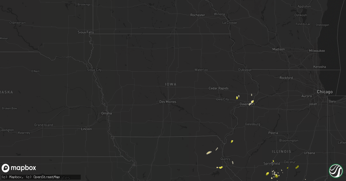
Hail Map in Iowa on May 27, 2018
Get this storm
May 27 map
$229
one time, instant access
Download today. No call, no setup
Keep the $229
Bought the map and want the full workflow? Apply the entire $229 to a subscription within 7 days. None of it is wasted.
Every map, not just this one
This buys you this map. Subscription and you get every map we run, in the markets you choose from a few cities to whole states to nationwide. Plus real-time alerts the moment a storm fires.
Contact data
Name, contact info, occupancy, even credit band for addresses in the footprint. You go from where it hit to who to call.
Become the source they trust
Unlimited branding weather history reports on demand. You already have the documented answer ready for the property owner, and you are the one who showed up with it.
Property data and RoofTrace estimates
Pull up any address you have got, its value and the exact code rules for that jurisdiction, straight from One Click Code. Then RoofTrace estimates the squares, pitch, and roof value, priced the way you price.
Storm reports in Iowa
Iowa
| Date | Description |
|---|---|
| 05/27/20183:21 PM CDT | A local report indicates 1.00 inch wind near 1 N LE CLAIRE |
| 05/27/20183:18 PM CDT | Correction to earlier report. The hail also was accompanied by minor wind damage of 1 inch diameter limbs and one inch of rain. |
| 05/27/20183:12 PM CDT | A local report indicates 1.00 inch wind near 2 SSW BENNETT |
| 05/27/20183:10 PM CDT | 1 inch diameter branches down. |
| 05/27/20183:10 PM CDT | Corrects previous hail report from 2 ssw bennett. |
| 05/27/20183:05 PM CDT | A local report indicates 1.00 inch wind near 2 SSW BENNETT |
| 05/27/20182:55 PM CDT | Hail has ended. |
| 05/27/20182:48 PM CDT | A local report indicates 1.00 inch wind near LE CLAIRE |
| 05/26/201811:20 PM CDT | At 419 PM CDT, a severe thunderstorm was located over Bettendorf, moving south at 5 mph. HAZARD...Quarter size hail. SOURCE...Radar indicated. IMPACT...Damage to vehicles is expected. Locations impacted include... Moline, Bettendorf, East Moline, Silvis, Le Claire, Hampton, Riverdale, Carbon Cliff, Panorama Park, Silvis Heights, Pleasant Valley, Campbells Island, Illiniwek Forest Preserve, Fishermans Corner, Rock Island County Fairgrounds and Rock Island Arsenal.This includes the following highways... Interstate 74 in Iowa near mile marker 5. Interstate 80 in Iowa between mile markers 301 and 305. Interstate 74 in Illinois between mile markers 1 and 3. |
| 05/26/201810:11 PM CDT | At 311 PM CDT, a severe thunderstorm was located over Bennett, or 8 miles southeast of Tipton, moving south at 10 mph. HAZARD...Quarter size hail. SOURCE...Radar indicated. IMPACT...Damage to vehicles is expected. Locations impacted include... Bennett, Bennett Park and Sunbury. This includes Interstate 80 in Iowa between mile markers 272 and 277. |
| 05/26/20189:49 PM CDT | At 248 PM CDT, a severe thunderstorm was located over Le Claire and Port Byron, or 8 miles northeast of Bettendorf, moving northeast at 10 mph. HAZARD...60 mph wind gusts and quarter size hail. SOURCE...Trained weather spotters. IMPACT...Hail damage to vehicles is expected. Expect wind damage to roofs, siding, and trees. Locations impacted include... Bettendorf, Camanche, Le Claire, Hampton, Port Byron, Erie, Rapids City, Albany, Princeton, Cordova, Hillsdale, Princeton Wildlife Area, Fishermans Corner and Illiniwek Forest Preserve.This includes the following highways... Interstate 80 in Iowa between mile markers 302 and 306. Interstate 80 in Illinois between mile markers 1 and 3. Interstate 88 between mile markers 1 and 2, and between mile markers10 and 20. |
All States Impacted by Hail Map on May 27, 2018
Cities Impacted by Hail Map on May 27, 2018
- Casper, WY
- Laramie, WY
- Buford, WY
- Ogallala, NE
- Saint Francis, KS
- Haxtun, CO
- Nokomis, IL
- Glenrock, WY
- Fort Morgan, CO
- New Raymer, CO
- Douglas, WY
- McDonald, KS
- Colby, KS
- Tribune, KS
- Ranchester, WY
- Sheridan, WY
- Bettendorf, IA
- East Moline, IL
- Le Claire, IA
- Saint Jacob, IL
- Snyder, CO
- Bethune, CO
- Burlington, CO
- Stratton, CO
- Idalia, CO
- Wray, CO
- Harrison, NE
- Leoti, KS
- Benkelman, NE
- Panhandle, TX
- Skellytown, TX
- Pampa, TX
- Brook, IN
- Paxton, NE
- Crawford, NE
- Evansville, WY
- Johnson, KS
- Elsie, NE
- Dieterich, IL
- Winner, SD
- Andover, SD
- Holyoke, CO
- Amherst, CO
- Kanorado, KS
- Effingham, IL
- Altamont, IL
- Cheyenne, WY
- Gruver, TX
- Stapleton, NE
- Morocco, IN
- Bethalto, IL
- Cottage Hills, IL
- East Alton, IL
- Yuma, CO
- Eckley, CO
- Knox City, MO
- Edina, MO
- Pine Ridge, SD
- Julesburg, CO
- Venango, NE
- Syracuse, KS
- Bartelso, IL
- Harvel, IL
- Morrisonville, IL
- Riverton, WY
- Lander, WY
- Winslow, IN
- Ulysses, KS
- Kendall, KS
- Lakin, KS
- Hot Springs, SD
- Springfield, IL
- Gering, NE
- Mission, SD
- Blunt, SD
- Mikado, MI
- Manson, IA
- Grant, NE
- Wauneta, NE
- Palisade, NE
- Saint Louis, MO
- Stockville, NE
- Vernon, CO
- Harrisville, MI
- Greenbush, MI
- Kirk, CO
- Akron, CO
- Groton, SD
- Saint Francis, SD
- Bennett, IA
- Wilton, IA
- Williams, MN
- Montrose, IL
- Teutopolis, IL
- Sigel, IL
- East Tawas, MI
- Watson, IL
- Tie Siding, WY
- Palmer, IL
- Taylorville, IL
- Brule, NE
- Clare, MI
- Atwood, KS
- Haigler, NE
- Tawas City, MI
- Buffalo Gap, SD
- Madrid, NE
- Imperial, NE
- Wood River, IL
- Fall Creek, WI
- Highland, IL
- Curtis, NE
- Moorefield, NE
- Farnam, NE
- Hayes Center, NE
- Mount Pleasant, MI
- Fort Washakie, WY
- Roggen, CO
- Wiggins, CO
- Conde, SD
- Sparrows Point, MD
- Dundalk, MD
- Fergus Falls, MN
- Alger, MI
- Sterling, MI
- Palmyra, MO
- Hannibal, MO
- Monroe City, MO
- Seibert, CO
- Waggoner, IL
- Sterling, CO
- Bird City, KS
- Edson, KS
- Vona, CO
- Lebanon, IL
- Whitney, NE
- Oelrichs, SD
- Oral, SD
- Edgemont, SD
- Elwood, NE
- Laurel, MT
- New Baden, IL
- Mascoutah, IL
- Liberty, IL
- Plainville, IL
- Wallace, NE
- Edwardsville, IL
- Centreville, MD
- Queenstown, MD
- Jeffrey City, WY
- Frederick, SD
- Stoneham, CO
- Bartley, NE
- Indianola, NE
- Virden, IL
- Auburn, IL
- Okawville, IL
- Addieville, IL
- Colfax, WI
- Chippewa Falls, WI
- Sugar City, CO
- Granite Canon, WY
- Onida, SD
- Scottsbluff, NE
- Hershey, NE
- Pawnee, IL
- Divernon, IL
- Champion, NE
- Keystone, NE
- Parks, NE
- Wall, SD
- Monticello, MO
- Williamstown, MO
- Saint Patrick, MO
- Wood, SD
- Hatley, WI
- Rosholt, WI
- Carthage, IL
- Goodland, KS
- Lemoyne, NE
- Maxwell, NE
- Lewellen, NE
- Winona, KS
- Roosevelt, MN
- Arapahoe, NE
- Moline, IL
- Anton, CO
- Lindon, CO
- La Belle, MO
- Baudette, MN
- Mitchell, NE
- Boyd, WI
- Levant, KS
- Ovid, CO
- Grover, CO
- Mosinee, WI
- New Liberty, IA
- Carlin, NV
- Brewster, KS
- New Florence, MO
- Velpen, IN
- Huntingburg, IN
- Raymond, IL
- Trenton, IL
- Roslyn, SD
- Elko, NV
- Marsland, NE
- O'Fallon, IL
- Otwell, IN
- Wanblee, SD
- Westport, PA
- Harrisburg, NE
- Moro, IL
- Worden, IL
- Dorsey, IL
- Trilla, IL
- Elwell, MI
- Riverdale, MI
- Roxana, IL
- Max, NE
- Stratton, NE
- Farmersville, IL
- De Witt, IA
- Farwell, MI
- Standish, MI
- Kentland, IN
- Goodland, IN
- Fairburn, SD
- Hermosa, SD
- Smithwick, SD
- Hampton, IL
- Port Byron, IL
- Rapids City, IL
- Manter, KS
- Hay Springs, NE
- Merino, CO
- Camanche, IA
- North Platte, NE
- Omer, MI
- Wheatland, WY
- Karval, CO
- Encampment, WY
- Waltonville, IL
- Mount Vernon, IL
- Howe, ID
- Coulterville, IL
- Kit Carson, CO
- Jim Falls, WI
- Pleasant Valley, IA
- Montgomery City, MO
- Big Springs, NE
- Atwood, CO
- Sidney, NE
- Arapahoe, WY
- Wayne City, IL
- Dahlgren, IL
- Bloomer, WI
- Hemingford, NE
- Cody, NE
- Tuthill, SD
- Pinconning, MI
- Bentley, MI
- Sherman, IL
- Bethany, IL
- Sullivan, IL
- Lovington, IL
- Moweaqua, IL
- Girard, IL
- Orchard, CO
- White Deer, TX
- Billings, MT


