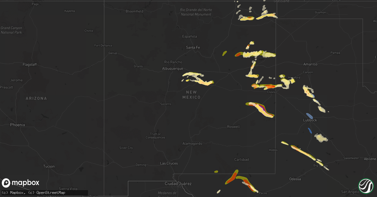
Hail Map in New Mexico on May 26, 2023
Get this storm
May 26 map
$229
one time, instant access
Download today. No call, no setup
Keep the $229
Bought the map and want the full workflow? Apply the entire $229 to a subscription within 7 days. None of it is wasted.
Every map, not just this one
This buys you this map. Subscription and you get every map we run, in the markets you choose from a few cities to whole states to nationwide. Plus real-time alerts the moment a storm fires.
Contact data
Name, contact info, occupancy, even credit band for addresses in the footprint. You go from where it hit to who to call.
Become the source they trust
Unlimited branding weather history reports on demand. You already have the documented answer ready for the property owner, and you are the one who showed up with it.
Property data and RoofTrace estimates
Pull up any address you have got, its value and the exact code rules for that jurisdiction, straight from One Click Code. Then RoofTrace estimates the squares, pitch, and roof value, priced the way you price.
Storm reports in New Mexico
New Mexico
| Date | Description |
|---|---|
| 05/26/20236:50 PM CDT | A local report indicates 1.00 inch wind near 11 NNE MELROSE |
| 05/26/20236:46 PM CDT | Report from mping: golf ball |
| 05/26/20236:36 PM CDT | Report from mping: golf ball |
| 05/26/20236:28 PM CDT | A local report indicates a tornado near 1 S ENCINO |
| 05/26/20236:25 PM CDT | A local report indicates 1.00 inch wind near 3 SW RANCHVALE |
| 05/26/20236:04 PM CDT | A local report indicates 2.70 inch wind near 6 WNW ENCINO |
| 05/26/20235:46 PM CDT | Report |
| 05/26/20235:46 PM CDT | Report from mping: ping pong ball |
| 05/26/20235:45 PM CDT | A local report indicates 1.50 inch wind near 9 WNW ENCINO |
| 05/26/20233:30 PM CDT | Minor leaf damage... Broken house windows. |
| 05/26/20233:05 PM CDT | A local report indicates 1.00 inch wind near 7 WSW MORIARTY |
| 05/26/20232:20 PM CDT | Hail lasted around 30 minutes. |
| 05/26/20231:00 AM CDT | Shredded leaves 1.5 and 2 inch stones. |
| 05/26/202312:15 AM CDT | A local report indicates 2.25 inch wind near 1 NE ELIDA |
| 05/26/202312:06 AM CDT | A local report indicates 1.75 inch wind near 1 NE ELIDA |
| 05/25/202311:53 PM CDT | A local report indicates 1.50 inch wind near ELIDA |
| 05/25/202311:23 PM CDT | Report from mping: hen egg |
| 05/25/202311:12 PM CDT | A local report indicates 1.75 inch wind near 2 NNE ELIDA |
| 05/25/202310:48 PM CDT | A local report indicates 1.50 inch wind near 3 NNE ELIDA |
| 05/25/202310:00 PM CDT | A local report indicates 75 MPH wind near 7 E TUCUMCARI |
| 05/25/20238:30 PM CDT | Report from mping: quarter |
| 05/25/20238:30 PM CDT | A local report indicates 1.75 inch wind near 3 SSW ENCINO |
| 05/25/20238:29 PM CDT | Report from mping: ping pong ball |
| 05/25/20238:14 PM CDT | Report from mping: half dollar |
| 05/25/20238:14 PM CDT | A local report indicates 1.25 inch wind near 4 S ENCINO |
| 05/25/20238:12 PM CDT | Report from mping: half dollar |
| 05/25/20238:08 PM CDT | Report from mping: quarter |
| 05/25/20238:05 PM CDT | Some stones up to 3.5 inch diameter. Broke car windshield. |
| 05/25/20238:00 PM CDT | A local report indicates 1.50 inch wind near 8 WNW PLEASANT HILL |
| 05/25/20238:00 PM CDT | A local report indicates 1.00 inch wind near 3 SSW ENCINO |
| 05/25/20238:00 PM CDT | . |
| 05/25/20237:56 PM CDT | Report from mping: quarter |
| 05/25/20237:55 PM CDT | Report from mping: quarter |
| 05/25/20237:43 PM CDT | Report from mping: quarter |
| 05/25/20237:42 PM CDT | Report from mping: half dollar |
All States Impacted by Hail Map on May 26, 2023
Cities Impacted by Hail Map on May 26, 2023
- Parks, NE
- Tucumcari, NM
- San Jon, NM
- Shallowater, TX
- Lubbock, TX
- Tahoka, TX
- Wilson, TX
- Tuttle, OK
- Newalla, OK
- Washington, OK
- Meeker, OK
- Norman, OK
- Gracemont, OK
- Minco, OK
- Tecumseh, OK
- Pocasset, OK
- Chickasha, OK
- Shawnee, OK
- Choctaw, OK
- Anadarko, OK
- Oklahoma City, OK
- Amber, OK
- Blanchard, OK
- Newcastle, OK
- Noble, OK
- Mcloud, OK
- Verden, OK
- Macomb, OK
- Robertson, WY
- Fort Bridger, WY
- Post, TX
- Odonnell, TX
- Justiceburg, TX
- Gail, TX
- Tijeras, NM
- Edgewood, NM
- Moriarty, NM
- Model, CO
- Twin Falls, ID
- Denver, CO
- Wheat Ridge, CO
- Arvada, CO
- Westminster, CO
- Brighton, CO
- Fort Lupton, CO
- Lander, WY
- Florence, CO
- Ault, CO
- Pierce, CO
- Malta, ID
- Nunn, CO
- Jeffrey City, WY
- Greeley, CO
- Lucerne, CO
- Seagraves, TX
- Seminole, TX
- Spearfish, SD
- Fort Stockton, TX
- Lead, SD
- Riverton, WY
- Thermopolis, WY
- Shoshoni, WY
- Colorado Springs, CO
- Estancia, NM
- Cloudcroft, NM
- Fountain, CO
- Peyton, CO
- Broadus, MT
- Weston, WY
- Fort Davis, TX
- Valentine, TX
- Hulett, WY
- Yoder, CO
- Rush, CO
- Calhan, CO
- Elbert, CO
- Kiowa, CO
- Cheyenne, WY
- Welch, TX
- Encino, NM
- Buffalo, WY
- Alzada, MT
- Melrose, NM
- Rogerson, ID
- Evergreen, CO
- Corral, ID
- Palermo, ND
- Parshall, ND
- Eaton, CO
- Fairfield, ID
- Kaycee, WY
- Killdeer, ND
- Crossville, TN
- Longmont, CO
- Englewood, CO
- Littleton, CO
- Mountain View, WY
- Lyman, WY
- Platteville, CO
- La Salle, CO
- Gilcrest, CO
- Golden, CO
- Hansen, ID
- Torreon, NM
- Wetmore, CO
- Milliken, CO
- Erie, CO
- Roosevelt, UT
- Kimberly, ID
- Casper, WY
- Meeteetse, WY
- Evansville, WY
- Raton, NM
- Trinidad, CO
- Aurora, CO
- Louisville, CO
- Broomfield, CO
- Lafayette, CO
- Shoshone, ID
- Moorcroft, WY
- Evans, CO
- Lamesa, TX
- Clovis, NM
- Ackerly, TX
- Texico, NM
- Lenorah, TX
- Knott, TX
- Balmorhea, TX
- Dayton, WY
- Ranchester, WY
- Decker, MT
- Sheridan, WY
- Big Spring, TX
- Bovina, TX
- Alpine, TX
- Conchas Dam, NM
- Salt Flat, TX
- Crow Agency, MT
- Friona, TX
- Hardin, MT
- Van Horn, TX
- Mosquero, NM
- Roy, NM
- Custer, MT
- Roswell, NM
- Elida, NM
- Pecos, TX
- Vaughn, NM
- House, NM
- Springer, NM
- Des Moines, NM
- Marfa, TX
- Rock Springs, WY
- Minot, ND
- Burlington, ND
- Manville, WY
- Des Lacs, ND
- New Town, ND
- Medicine Bow, WY
- Grenville, NM
- Lance Creek, WY
- Lost Springs, WY
- Shawnee, WY
- Wheatland, WY
- Akron, CO
- Glendo, WY
- Sierra Blanca, TX
- Kim, CO
- Byers, CO
- Fairfield, ND
- Hillrose, CO
- Brush, CO
- Tarzan, TX
- Devils Tower, WY
- Watford City, ND
- Sundance, WY
- Powell, WY
- Lovell, WY
- Ramah, CO
- Parkman, WY
- Upton, WY
- Shepherd, MT
- Keene, ND
- Jay Em, WY
- Lusk, WY
- Clearmont, WY
- Wolf, WY
- Wyola, MT
- Grassy Butte, ND
- Willard, NM
- Hereford, TX
- Clayton, NM
- Portales, NM
- Greybull, WY
- Byron, WY
- Pep, NM
- Summerfield, TX
- Trementina, NM
- Garita, NM
- Las Vegas, NM
- Tulia, TX
- Nazareth, TX
- Hart, TX
- Kress, TX
- Cherokee, AL
- Iuka, MS
- Mcalister, NM
- Farwell, TX
- Plainview, TX
- Logan, NM
- Nara Visa, NM
- Floydada, TX
- Fluvanna, TX
- Broadview, NM
- Lockney, TX
- Ralls, TX
- Crosbyton, TX
- Grady, NM
- Stratford, TX


