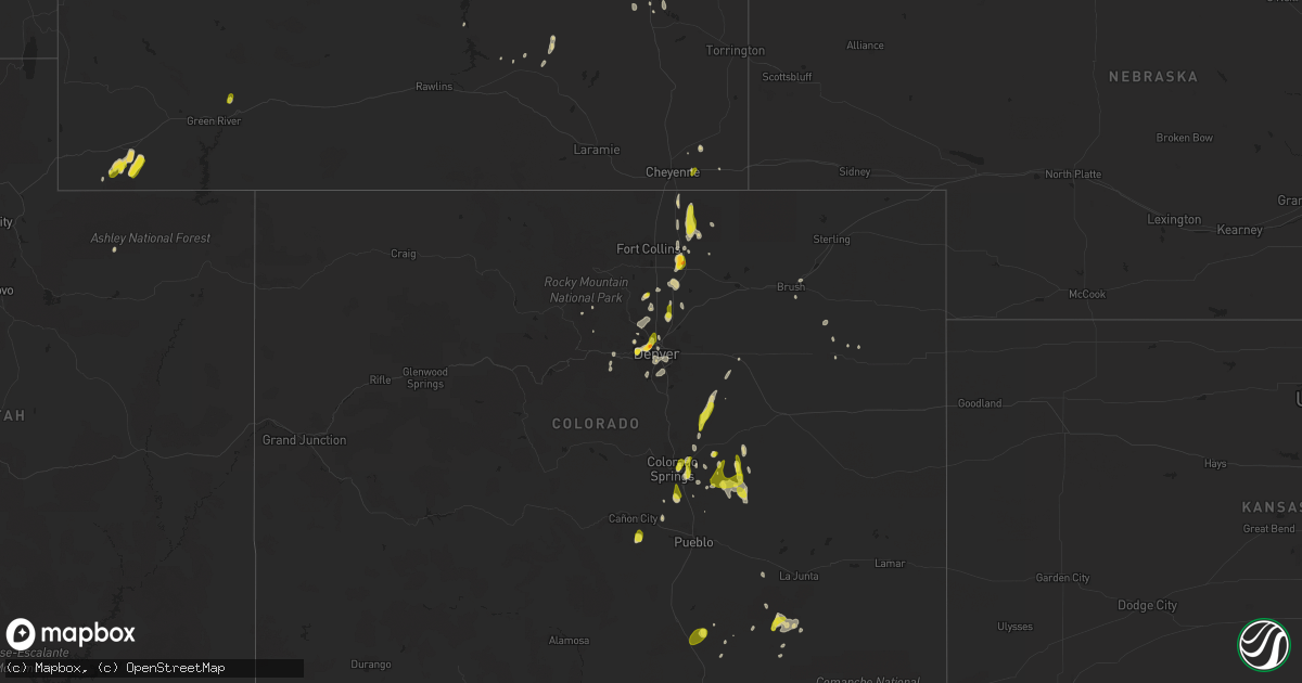
Hail Map on May 26, 2023
Get this storm
May 26 map
$229
one time, instant access
Download today. No call, no setup
Keep the $229
Bought the map and want the full workflow? Apply the entire $229 to a subscription within 7 days. None of it is wasted.
Every map, not just this one
This buys you this map. Subscription and you get every map we run, in the markets you choose from a few cities to whole states to nationwide. Plus real-time alerts the moment a storm fires.
Contact data
Name, contact info, occupancy, even credit band for addresses in the footprint. You go from where it hit to who to call.
Become the source they trust
Unlimited branding weather history reports on demand. You already have the documented answer ready for the property owner, and you are the one who showed up with it.
Property data and RoofTrace estimates
Pull up any address you have got, its value and the exact code rules for that jurisdiction, straight from One Click Code. Then RoofTrace estimates the squares, pitch, and roof value, priced the way you price.
States Impacted by Hail Map on May 26, 2023
Storm reports
Wyoming
| Date | Description |
|---|---|
| 05/26/20236:58 PM CDT | A local report indicates 1.25 inch wind near RANCHESTER |
| 05/26/20236:57 PM CDT | A local report indicates 1.00 inch wind near 6 SW DAYTON |
| 05/26/20236:55 PM CDT | A local report indicates 1.00 inch wind near DAYTON |
| 05/26/20235:00 PM CDT | Facebook post. Event occurred at i-80 mm 372 port of entry. |
| 05/26/20234:50 PM CDT | A local report indicates 1.25 inch wind near 5 SW BYRON |
| 05/26/20234:40 PM CDT | A local report indicates 1.00 inch wind near 6 ESE RIVERTON |
| 05/26/20234:15 PM CDT | A local report indicates 59 MPH wind near RIVERTON |
| 05/26/20234:05 PM CDT | A local report indicates 1.00 inch wind near 15 ESE CODY |
| 05/26/20233:20 PM CDT | A local report indicates 1.00 inch wind near 8 NNW ROCK SPRINGS |
| 05/26/20231:10 PM CDT | Reported neighbors shed roof removed during the storm. Tree branches down of unknown size. Pea sized hail. Time estimated from radar. |
| 05/25/20237:12 PM CDT | Nickel to quarter size hail. |
Colorado
| Date | Description |
|---|---|
| 05/26/20235:54 PM CDT | A local report indicates a tornado near 1 W SNYDER |
| 05/26/20235:47 PM CDT | A local report indicates 1.00 inch wind near 7 SW CALHAN |
| 05/26/20235:33 PM CDT | Mostly dime sized... A few quarters. |
| 05/26/20235:32 PM CDT | A local report indicates 1.00 inch wind near ELBERT |
| 05/26/20235:29 PM CDT | Brief... 15-20 second spin-up... Possibly on converging outflow boundaries. |
| 05/26/20235:28 PM CDT | A local report indicates 60 MPH wind near 2 WNW WIGGINS |
| 05/26/20235:00 PM CDT | Time and location estimated. |
| 05/26/20234:48 PM CDT | A local report indicates 1.00 inch wind near COLORADO SPRINGS |
| 05/26/20234:16 PM CDT | A local report indicates 1.50 inch wind near 2 S LUCERNE |
| 05/26/20234:16 PM CDT | A local report indicates 1.25 inch wind near 2 S LUCERNE |
| 05/26/20234:15 PM CDT | A local report indicates 1.00 inch wind near 2 NE GREELEY |
| 05/26/20234:12 PM CDT | A local report indicates 1.00 inch wind near 1 S GREELEY |
| 05/26/20233:45 PM CDT | A local report indicates 1.00 inch wind near 2 N FEDERAL HEIGHTS |
| 05/26/20233:42 PM CDT | A local report indicates 1.00 inch wind near 1 ENE WESTMINSTER |
| 05/26/20233:35 PM CDT | A local report indicates 1.25 inch wind near 3 NE LONGMONT |
| 05/26/20233:29 PM CDT | Report from mping: ping pong ball |
| 05/26/20233:29 PM CDT | A local report indicates 1.25 inch wind near 2 NNW DENVER |
| 05/26/20233:26 PM CDT | A local report indicates 1.25 inch wind near FEDERAL HEIGHTS |
| 05/26/20233:25 PM CDT | A local report indicates 1.25 inch wind near 2 NW DENVER |
| 05/26/20233:25 PM CDT | A local report indicates 1.00 inch wind near 1 NE PLEASANT VIEW |
| 05/26/20233:25 PM CDT | Report from mping: quarter |
| 05/26/20233:00 PM CDT | Asos station kase aspen-pitkin cnty airport. |
| 05/25/20237:45 PM CDT | Time estimated. |
Washington
| Date | Description |
|---|---|
| 05/26/20234:40 PM CDT | Public sent in video of a land spout tornado. No damage or injuries reported. |
Idaho
| Date | Description |
|---|---|
| 05/26/20234:17 PM CDT | A local report indicates 1.00 inch wind near HEGLAR |
| 05/26/20233:35 PM CDT | A local report indicates a tornado near 8 NNE STANDROD |
| 05/26/20233:25 PM CDT | A local report indicates 1.25 inch wind near HOLLISTER |
| 05/26/20233:22 PM CDT | A local report indicates 1.00 inch wind near HOLLISTER |
| 05/26/20233:19 PM CDT | A local report indicates 1.00 inch wind near HOLLISTER |
New Mexico
| Date | Description |
|---|---|
| 05/26/20236:50 PM CDT | A local report indicates 1.00 inch wind near 11 NNE MELROSE |
| 05/26/20236:46 PM CDT | Report from mping: golf ball |
| 05/26/20236:36 PM CDT | Report from mping: golf ball |
| 05/26/20236:28 PM CDT | A local report indicates a tornado near 1 S ENCINO |
| 05/26/20236:25 PM CDT | A local report indicates 1.00 inch wind near 3 SW RANCHVALE |
| 05/26/20236:04 PM CDT | A local report indicates 2.70 inch wind near 6 WNW ENCINO |
| 05/26/20235:46 PM CDT | Report from mping: ping pong ball |
| 05/26/20235:46 PM CDT | Report |
| 05/26/20235:45 PM CDT | A local report indicates 1.50 inch wind near 9 WNW ENCINO |
| 05/26/20233:30 PM CDT | Minor leaf damage... Broken house windows. |
| 05/26/20233:05 PM CDT | A local report indicates 1.00 inch wind near 7 WSW MORIARTY |
| 05/26/20232:20 PM CDT | Hail lasted around 30 minutes. |
| 05/26/20231:00 AM CDT | Shredded leaves 1.5 and 2 inch stones. |
| 05/26/202312:15 AM CDT | A local report indicates 2.25 inch wind near 1 NE ELIDA |
| 05/26/202312:06 AM CDT | A local report indicates 1.75 inch wind near 1 NE ELIDA |
| 05/25/202311:53 PM CDT | A local report indicates 1.50 inch wind near ELIDA |
| 05/25/202311:23 PM CDT | Report from mping: hen egg |
| 05/25/202311:12 PM CDT | A local report indicates 1.75 inch wind near 2 NNE ELIDA |
| 05/25/202310:48 PM CDT | A local report indicates 1.50 inch wind near 3 NNE ELIDA |
| 05/25/202310:00 PM CDT | A local report indicates 75 MPH wind near 7 E TUCUMCARI |
| 05/25/20238:30 PM CDT | Report from mping: quarter |
| 05/25/20238:30 PM CDT | A local report indicates 1.75 inch wind near 3 SSW ENCINO |
| 05/25/20238:29 PM CDT | Report from mping: ping pong ball |
| 05/25/20238:14 PM CDT | A local report indicates 1.25 inch wind near 4 S ENCINO |
| 05/25/20238:14 PM CDT | Report from mping: half dollar |
| 05/25/20238:12 PM CDT | Report from mping: half dollar |
| 05/25/20238:08 PM CDT | Report from mping: quarter |
| 05/25/20238:05 PM CDT | Some stones up to 3.5 inch diameter. Broke car windshield. |
| 05/25/20238:00 PM CDT | A local report indicates 1.50 inch wind near 8 WNW PLEASANT HILL |
| 05/25/20238:00 PM CDT | . |
| 05/25/20238:00 PM CDT | A local report indicates 1.00 inch wind near 3 SSW ENCINO |
| 05/25/20237:56 PM CDT | Report from mping: quarter |
| 05/25/20237:55 PM CDT | Report from mping: quarter |
| 05/25/20237:43 PM CDT | Report from mping: quarter |
| 05/25/20237:42 PM CDT | Report from mping: half dollar |
Texas
| Date | Description |
|---|---|
| 05/26/20236:56 PM CDT | A local report indicates 1.25 inch wind near BALMORHEA |
| 05/26/20236:33 PM CDT | A local report indicates 1.25 inch wind near 2 N FLOWER GROVE |
| 05/26/20236:33 PM CDT | Report relayed by broadcast media. Time estimated from radar. |
| 05/26/20236:22 PM CDT | Roof partially blown off of a shed... Minor tree damage. |
| 05/26/20236:15 PM CDT | 1 inch diameter hail observed at mcdonald observatory. |
| 05/26/20235:22 PM CDT | Corrects previous tstm wnd dmg report from 1 n fort davis. Roof partially blown off of a shed... Minor tree damage. |
| 05/26/20235:20 PM CDT | Half-dollar sized hail near fort davis. |
| 05/26/20237:40 AM CDT | Tree limb downed on ttu campus. Time estimated. |
| 05/26/20237:33 AM CDT | A local report indicates 62 MPH wind near 6 NNE LUBBOCK |
| 05/26/20237:20 AM CDT | S.o. Dispatch reports down power line. Estimated time 7:20am. |
| 05/26/20237:10 AM CDT | A local report indicates 59 MPH wind near 4 NNE SHALLOWATER |
| 05/26/20234:17 AM CDT | Measured by the ttu west texas mesonet |
| 05/26/20234:03 AM CDT | Measured by the ttu west texas mesonet |
| 05/26/20232:54 AM CDT | Measured by the ttu west texas mesonet |
| 05/25/20238:56 PM CDT | Mesonet station fdst2 fort davis. Time estimated by radar. |
| 05/25/20238:30 PM CDT | Quarter to half dollar size hail observed at the davis mountains resort. |
| 05/25/20237:45 PM CDT | A local report indicates 1.00 inch wind near 5 E BIG SPRING |
| 05/25/20237:20 PM CDT | Ping pong to golf ball sized hail observed in alpine. |
| 05/25/20237:16 PM CDT | Corrects previous tstm wnd dmg report from 2 n alpine. Corrects previous tstm wnd dmg report from 2 n alpine. Wind driven hail damage at big bend regional medical cente |
Montana
| Date | Description |
|---|---|
| 05/26/20236:33 PM CDT | A local report indicates 1.00 inch wind near 1 E RIDGE |
Cities Impacted by Hail Map on May 26, 2023
- Parks, NE
- Tucumcari, NM
- San Jon, NM
- Shallowater, TX
- Lubbock, TX
- Tahoka, TX
- Wilson, TX
- Tuttle, OK
- Newalla, OK
- Washington, OK
- Meeker, OK
- Norman, OK
- Gracemont, OK
- Minco, OK
- Tecumseh, OK
- Pocasset, OK
- Chickasha, OK
- Shawnee, OK
- Choctaw, OK
- Anadarko, OK
- Oklahoma City, OK
- Amber, OK
- Blanchard, OK
- Newcastle, OK
- Noble, OK
- Mcloud, OK
- Verden, OK
- Macomb, OK
- Robertson, WY
- Fort Bridger, WY
- Post, TX
- Odonnell, TX
- Justiceburg, TX
- Gail, TX
- Tijeras, NM
- Edgewood, NM
- Moriarty, NM
- Model, CO
- Twin Falls, ID
- Denver, CO
- Wheat Ridge, CO
- Arvada, CO
- Westminster, CO
- Brighton, CO
- Fort Lupton, CO
- Lander, WY
- Florence, CO
- Ault, CO
- Pierce, CO
- Malta, ID
- Nunn, CO
- Jeffrey City, WY
- Greeley, CO
- Lucerne, CO
- Seagraves, TX
- Seminole, TX
- Spearfish, SD
- Fort Stockton, TX
- Lead, SD
- Riverton, WY
- Thermopolis, WY
- Shoshoni, WY
- Colorado Springs, CO
- Estancia, NM
- Cloudcroft, NM
- Fountain, CO
- Peyton, CO
- Broadus, MT
- Weston, WY
- Fort Davis, TX
- Valentine, TX
- Hulett, WY
- Yoder, CO
- Rush, CO
- Calhan, CO
- Elbert, CO
- Kiowa, CO
- Cheyenne, WY
- Welch, TX
- Encino, NM
- Buffalo, WY
- Alzada, MT
- Melrose, NM
- Rogerson, ID
- Evergreen, CO
- Corral, ID
- Palermo, ND
- Parshall, ND
- Eaton, CO
- Fairfield, ID
- Kaycee, WY
- Killdeer, ND
- Crossville, TN
- Longmont, CO
- Englewood, CO
- Littleton, CO
- Mountain View, WY
- Lyman, WY
- Platteville, CO
- La Salle, CO
- Gilcrest, CO
- Golden, CO
- Hansen, ID
- Torreon, NM
- Wetmore, CO
- Milliken, CO
- Erie, CO
- Roosevelt, UT
- Kimberly, ID
- Casper, WY
- Meeteetse, WY
- Evansville, WY
- Raton, NM
- Trinidad, CO
- Aurora, CO
- Louisville, CO
- Broomfield, CO
- Lafayette, CO
- Shoshone, ID
- Moorcroft, WY
- Evans, CO
- Lamesa, TX
- Clovis, NM
- Ackerly, TX
- Texico, NM
- Lenorah, TX
- Knott, TX
- Balmorhea, TX
- Dayton, WY
- Ranchester, WY
- Decker, MT
- Sheridan, WY
- Big Spring, TX
- Bovina, TX
- Alpine, TX
- Conchas Dam, NM
- Salt Flat, TX
- Crow Agency, MT
- Friona, TX
- Hardin, MT
- Van Horn, TX
- Mosquero, NM
- Roy, NM
- Custer, MT
- Roswell, NM
- Elida, NM
- Pecos, TX
- Vaughn, NM
- House, NM
- Springer, NM
- Des Moines, NM
- Marfa, TX
- Rock Springs, WY
- Minot, ND
- Burlington, ND
- Manville, WY
- Des Lacs, ND
- New Town, ND
- Medicine Bow, WY
- Grenville, NM
- Lance Creek, WY
- Lost Springs, WY
- Shawnee, WY
- Wheatland, WY
- Akron, CO
- Glendo, WY
- Sierra Blanca, TX
- Kim, CO
- Byers, CO
- Fairfield, ND
- Hillrose, CO
- Brush, CO
- Tarzan, TX
- Devils Tower, WY
- Watford City, ND
- Sundance, WY
- Powell, WY
- Lovell, WY
- Ramah, CO
- Parkman, WY
- Upton, WY
- Shepherd, MT
- Keene, ND
- Jay Em, WY
- Lusk, WY
- Clearmont, WY
- Wolf, WY
- Wyola, MT
- Grassy Butte, ND
- Willard, NM
- Hereford, TX
- Clayton, NM
- Portales, NM
- Greybull, WY
- Byron, WY
- Pep, NM
- Summerfield, TX
- Trementina, NM
- Garita, NM
- Las Vegas, NM
- Tulia, TX
- Nazareth, TX
- Hart, TX
- Kress, TX
- Cherokee, AL
- Iuka, MS
- Mcalister, NM
- Farwell, TX
- Plainview, TX
- Logan, NM
- Nara Visa, NM
- Floydada, TX
- Fluvanna, TX
- Broadview, NM
- Lockney, TX
- Ralls, TX
- Crosbyton, TX
- Grady, NM
- Stratford, TX