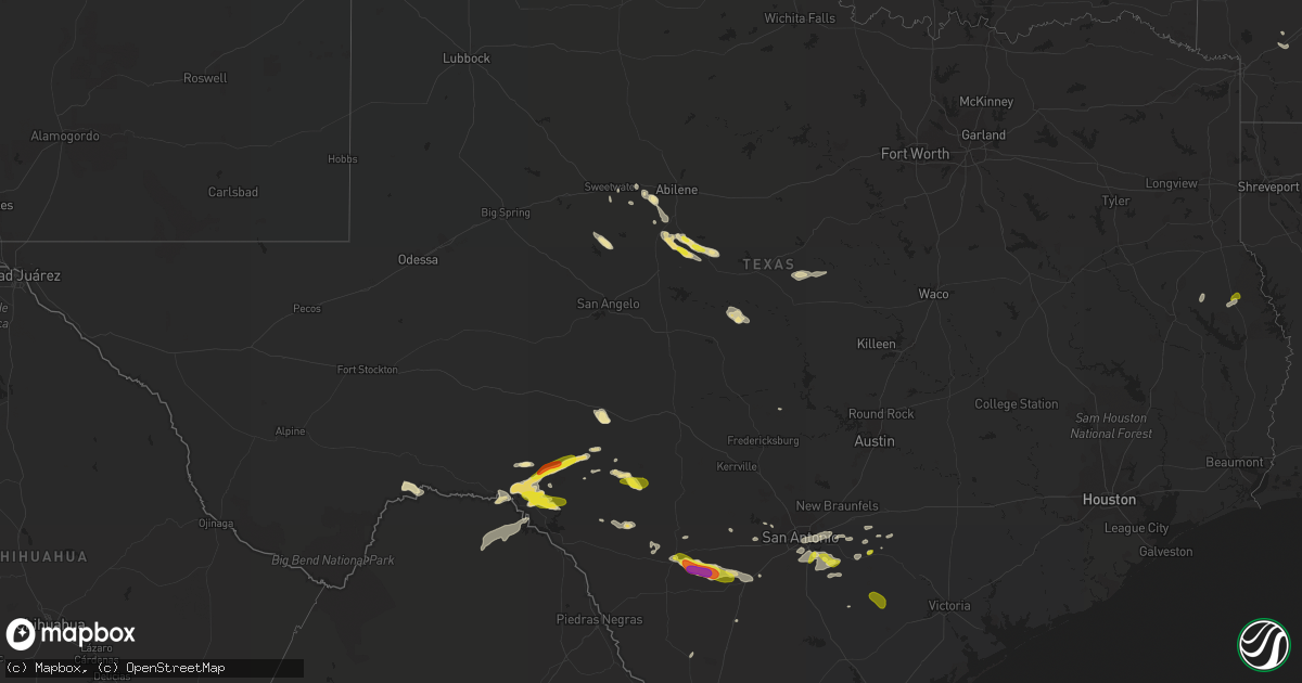
Hail Map in Texas on May 25, 2020
Get this storm
May 25 map
$229
one time, instant access
Download today. No call, no setup
Keep the $229
Bought the map and want the full workflow? Apply the entire $229 to a subscription within 7 days. None of it is wasted.
Every map, not just this one
This buys you this map. Subscription and you get every map we run, in the markets you choose from a few cities to whole states to nationwide. Plus real-time alerts the moment a storm fires.
Contact data
Name, contact info, occupancy, even credit band for addresses in the footprint. You go from where it hit to who to call.
Become the source they trust
Unlimited branding weather history reports on demand. You already have the documented answer ready for the property owner, and you are the one who showed up with it.
Property data and RoofTrace estimates
Pull up any address you have got, its value and the exact code rules for that jurisdiction, straight from One Click Code. Then RoofTrace estimates the squares, pitch, and roof value, priced the way you price.
Storm reports in Texas
Texas
| Date | Description |
|---|---|
| 05/25/20205:43 PM CDT | Report of nickel to quarter-sized hail. |
| 05/25/20205:13 PM CDT | Multiple trees reported down in and near the mount pleasant area. Damage on cr 1230 north of town... Trees on some homes... Damage to cattle trailer... Power poles and |
| 05/25/20205:05 PM CDT | An ef-1 tornado with estimated maximum winds near 100 mph touched down near the intersection of county road 1220 and county road 1230... Where it snapped and uprooted n |
| 05/25/20207:10 AM CDT | At 1209 AM CDT, severe thunderstorms were located along a line extending from near Taft to near Bay Area Medical Center to 10 miles southwest of Kings Crossing Golf Course, moving east at 45 mph. HAZARD...60 mph wind gusts. SOURCE...Radar indicated. IMPACT...Expect damage to roofs, siding, and trees. Locations impacted include... Corpus Christi, Portland, Robstown, Port Aransas, Taft, Corpus Christi International Airport, Ingleside, Aransas Pass, Odem, Gregory, Ingleside On The Bay, Flour Bluff, Christus Spohn Hospital South, Corpus Christi North Beach, Padre Balli Park, Bay Area Medical Center, Padre Isles Country Club, Corpus Christi Del Mar East Campus, Texas A&M University Corpus Christi and Clarkwood. |
| 05/25/20207:01 AM CDT | At 1200 AM CDT, a severe thunderstorm was located 11 miles west of Rudolph, or 12 miles northeast of San Manuel, moving northeast at 30 mph. HAZARD...60 mph wind gusts and quarter size hail. SOURCE...Radar indicated. IMPACT...Hail damage to vehicles is expected. Expect wind damage to roofs, siding, and trees. Locations impacted include... Raymondville, Armstrong, Port Mansfield, Hargill, Rachal, Lasara, San Manuel, Linn, San Perlita and Red Gate.This includes the following highways... Interstate Highway 69 E between mile markers 47 and 51. US Highway 77 between mile markers 730 and 762. US Highway 281 between mile markers 734 and 762. |
| 05/25/20206:38 AM CDT | At 1138 PM CDT, a severe thunderstorm was located 7 miles northwest of Frio Town, or 17 miles northeast of Batesville, moving east at 40 mph. HAZARD...Golf ball size hail. SOURCE...Radar indicated. IMPACT...People and animals outdoors will be injured. Expect damage to roofs, siding, windows, and vehicles. Locations impacted include... Pearsall, North Pearsall, Moore, Bigfoot, Schattel, Frio Town and Three Oaks. |
| 05/25/20206:36 AM CDT | At 1136 PM CDT, severe thunderstorms were located along a line extending from 6 miles southwest of Palmeto State Park to near Gillett, moving east at 50 mph. HAZARD...Quarter size hail. SOURCE...Radar indicated. IMPACT...Damage to vehicles is expected. Locations impacted include... Cuero, Gonzales, Yoakum, Schulenburg, Hallettsville, Shiner, Flatonia, Moulton, Nixon, Smiley, Cheapside, Hochheim, Palmeto State Park, Gillett, Westhoff, Komensky, Henkhaus, Belmont, Ottine and Ecleto. |
| 05/25/20206:11 AM CDT | At 1111 PM CDT, a severe thunderstorm was located near Uvalde, moving east at 35 mph. HAZARD...Quarter size hail. SOURCE...Public. IMPACT...Damage to vehicles is expected. Locations impacted include... Uvalde, Sabinal, Knippa and Frio Town. |
| 05/25/20204:39 AM CDT | At 939 PM CDT, a severe thunderstorm was located 8 miles southwest of Juno, moving east at 30 mph. HAZARD...Quarter size hail. SOURCE...Radar indicated. IMPACT...Damage to vehicles is expected. Locations impacted include... Juno. |
| 05/25/20204:09 AM CDT | At 909 PM CDT, a severe thunderstorm was located near Viboras, moving north at 35 mph. HAZARD...Golf ball size hail and 60 mph wind gusts. SOURCE...Radar indicated. IMPACT...People and animals outdoors will be injured. Expect hail damage to roofs, siding, windows, and vehicles. Expect wind damage to roofs, siding, and trees. Locations impacted include... Viboras, Escobas, Guerra and Randado. |
| 05/25/20203:42 AM CDT | At 842 PM CDT, a severe thunderstorm was located over El Sauz, moving northeast at 25 mph. HAZARD...Two inch hail and 60 mph wind gusts. SOURCE...Law enforcement. IMPACT...People and animals outdoors will be injured. Expect hail damage to roofs, siding, windows, and vehicles. Expect wind damage to roofs, siding, and trees. Locations impacted include... Viboras, El Sauz, La Gloria, Santa Elena and Diamond O Ranch Airport. |
| 05/25/20203:22 AM CDT | At 822 PM CDT, a severe thunderstorm was located near Comstock, moving east at 30 mph. HAZARD...Quarter size hail. SOURCE...Radar indicated. IMPACT...Damage to vehicles is expected. Locations impacted include... Comstock, Loma Alta, Vinegarone, Devils River State Nat Area Del Norte, Devils River State Nat Area Big Satan, and Pafford Crossing. |
| 05/25/20203:20 AM CDT | At 818 PM CDT, a severe thunderstorm was located 14 miles north of Loma Alta, moving east at 35 mph. HAZARD...Quarter size hail. SOURCE...Radar indicated. IMPACT...Damage to vehicles is expected. This severe thunderstorm will cross Hwy 277 and remain over mainly rural areas of northwestern Edwards and northeastern Val Verde Counties. |
| 05/25/20203:11 AM CDT | At 810 PM CDT, a severe thunderstorm was located 12 miles north of Long Point, or 15 miles east of Comstock, moving southeast at 20 mph. HAZARD...Quarter size hail. SOURCE...Radar indicated. IMPACT...Damage to vehicles is expected. Locations impacted include... Devils Shores, Devils River State Nat Area Big Satan, and Pafford Crossing. |
| 05/25/20202:55 AM CDT | At 754 PM CDT, a severe thunderstorm was located about 10 miles south of Roma, moving northeast at 25 mph. HAZARD...Golf ball size hail and 60 mph wind gusts. SOURCE...Radar indicated. IMPACT...People and animals outdoors will be injured. Expect hail damage to roofs, siding, windows, and vehicles. Expect wind damage to roofs, siding, and trees. Locations impacted include... Rio Grande City, Roma, Escobares, El Sauz, Garciasville, La Rosita, Los Alvarez, Fort Ringgold County Park, Garceno and Falcon Dam.This includes US Highway 83 between mile markers 792 and 828. |
| 05/25/20202:38 AM CDT | At 737 PM CDT, a severe thunderstorm was located 10 miles southeast of Juno, moving northeast at 25 mph. HAZARD...Ping pong ball size hail. SOURCE...Radar indicated. IMPACT...People and animals outdoors will be injured. Expect damage to roofs, siding, windows, and vehicles. Locations impacted include... Devils River State Nat Area Del Norte. |
| 05/25/20202:22 AM CDT | At 722 PM CDT, a severe thunderstorm was located 11 miles south of Aguilares, or 19 miles north of Bustamante, moving southeast at 20 mph. HAZARD...60 mph wind gusts and half dollar size hail. SOURCE...Radar indicated. IMPACT...Hail damage to vehicles is expected. Expect wind damage to roofs, siding, and trees. This severe thunderstorm will remain over mainly rural areas of southeastern Webb County. |
| 05/25/20202:16 AM CDT | At 715 PM CDT, a severe thunderstorm was located 7 miles north of Comstock, moving southeast at 15 mph. HAZARD...Quarter size hail. SOURCE...Radar indicated. IMPACT...Damage to vehicles is expected. Locations impacted include... Comstock, Devils River State Nat Area Big Satan, and Pafford Crossing. |
| 05/25/20202:15 AM CDT | At 714 PM CDT, a severe thunderstorm was located 8 miles south of Aguilares, moving south at 20 mph. HAZARD...60 mph wind gusts and half dollar size hail. SOURCE...Radar indicated. IMPACT...Hail damage to vehicles is expected. Expect wind damage to roofs, siding, and trees. Locations impacted include... Thompsonville. |
| 05/25/20202:08 AM CDT | At 708 PM CDT, a severe thunderstorm was located 14 miles northeast of Shumla, or 16 miles southwest of Juno, moving northeast at 15 mph. HAZARD...Quarter size hail. SOURCE...Radar indicated. IMPACT...Damage to vehicles is expected. Locations impacted include... Juno and Bakers Crossing. |
| 05/25/20201:47 AM CDT | At 646 PM CDT, a severe thunderstorm was located near Aguilares, or 22 miles southeast of Laredo, moving southeast at 15 mph. HAZARD...60 mph wind gusts and quarter size hail. SOURCE...Radar indicated. IMPACT...Hail damage to vehicles is expected. Expect wind damage to roofs, siding, and trees. Locations impacted include... Oilton, Mirando City and Aguilares. |
| 05/25/20201:35 AM CDT | At 635 PM CDT, a severe thunderstorm was located near Shumla, or 13 miles east of Langtry, moving east at 30 mph. HAZARD...Quarter size hail. SOURCE...Radar indicated. IMPACT...Damage to vehicles is expected. Locations impacted include... Comstock, Shumla, and Devils River State Nat Area Big Satan. |
| 05/25/202012:55 AM CDT | At 555 PM CDT, a severe thunderstorm was located 11 miles north of Bruni, or 21 miles northwest of Hebbronville, moving east at 10 mph. HAZARD...60 mph wind gusts and quarter size hail. SOURCE...Radar indicated. IMPACT...Hail damage to vehicles is expected. Expect wind damage to roofs, siding, and trees. This severe thunderstorm will remain over mainly rural areas of southwestern Duval and east central Webb Counties. |
| 05/25/202012:52 AM CDT | At 552 PM CDT, severe thunderstorms were located along a line extending from near Waskom to near Greenwood to 6 miles west of Stonewall to 10 miles northeast of Logansport, moving northeast at 25 mph. HAZARD...60 mph wind gusts and penny size hail. SOURCE...Radar indicated. IMPACT...Expect damage to roofs, siding, and trees. Locations impacted include... Shreveport, Bossier City, Marshall, Greenwood, Blanchard, Waskom, Benton, Stonewall, Mooringsport, Elysian Fields, Fosters, Scottsville, Keachi, Grand Cane, Longstreet, Keat Chie, Ferguson, Spring Ridge, Cross Lake and Kingston. |
| 05/25/202012:22 AM CDT | At 522 PM CDT, a severe thunderstorm was located 12 miles northeast of Oilton, or 24 miles southwest of Freer, moving east at 15 mph. HAZARD...60 mph wind gusts and quarter size hail. SOURCE...Radar indicated. IMPACT...Hail damage to vehicles is expected. Expect wind damage to roofs, siding, and trees. This severe thunderstorm will remain over mainly rural areas of west central Duval and southeastern Webb Counties. |
| 05/25/202012:07 AM CDT | Picture of quarter size hail received in runge. |
| 05/24/202011:16 PM CDT | At 416 AM CDT, a severe thunderstorm was located over Alvin, moving northeast at 30 mph. HAZARD...60 mph wind gusts. SOURCE...Radar indicated. IMPACT...Expect damage to roofs, siding, and trees. Locations impacted include... Pasadena, southeastern Pearland, League City, Friendswood, La Porte, Deer Park, Alvin, Dickinson, South Houston, Santa Fe, Seabrook, Webster, Kemah, Clear Lake, South Belt / Ellington, Nassau Bay, Taylor Lake Village, El Lago, Shoreacres and Clear Lake Shores. |
| 05/24/202011:10 PM CDT | Quarter size hail reported near sh-97 and us-181. |
| 05/24/202011:07 PM CDT | Report from mping: half dollar |
| 05/24/20208:20 PM CDT | Reported by roma city police dept. |
| 05/24/20208:18 PM CDT | Social media public report of ping pong ball size hail. |
All States Impacted by Hail Map on May 25, 2020
Cities Impacted by Hail Map on May 25, 2020
- Zapata, TX
- Garciasville, TX
- Guerra, TX
- Grulla, TX
- San Ygnacio, TX
- Rio Grande City, TX
- Roma, TX
- Novice, TX
- Goldsboro, TX
- Coleman, TX
- Granby, MO
- Pineville, MO
- Noel, MO
- Siloam Springs, AR
- Hiwasse, AR
- Bentonville, AR
- Gentry, AR
- Gravette, AR
- Bella Vista, AR
- Stella, MO
- Centerton, AR
- Sulphur Springs, AR
- Summers, AR
- Decatur, AR
- Neosho, MO
- Anderson, MO
- Fayetteville, AR
- Goodman, MO
- Tallassee, TN
- Comstock, TX
- Toledo, IL
- Lerna, IL
- Marathon, TX
- Kingsville, TX
- Hebbronville, TX
- Laredo, TX
- Brantwood, WI
- Ogema, WI
- Tripoli, WI
- Maiden Rock, WI
- Mondovi, WI
- Durand, WI
- Uvalde, TX
- Sabinal, TX
- Knippa, TX
- Pepin, WI
- Freer, TX
- Hamilton, TX
- Champaign, IL
- Chambersburg, IL
- Alma, AR
- Lavaca, AR
- San Antonio, TX
- Leslie, MO
- Sullivan, MO
- Beaufort, MO
- Floresville, TX
- Merkel, TX
- Topeka, IL
- Holcombe, WI
- Cornell, WI
- Lowpoint, IL
- Metamora, IL
- Medford, WI
- Del Rio, TX
- Vonore, TN
- Catarina, TX
- Alice, TX
- Lake City, MN
- Abilene, TX
- Ramsey, IL
- Alpine, TN
- Monroe, TN
- Hermitage, TN
- Mount Juliet, TN
- Realitos, TX
- Nixon, TX
- Stockdale, TX
- Le Roy, IL
- Pearsall, TX
- Batesville, TX
- D Hanis, TX
- Gore, OK
- Vian, OK
- Jay, OK
- Westmoreland, TN
- Cadott, WI
- Sheldon, WI
- Penn Yan, NY
- New Cambria, MO
- Premont, TX
- Concepcion, TX
- Richland Springs, TX
- Rochelle, TX
- Barksdale, TX
- Rocksprings, TX
- Rochester, MN
- Millville, MN
- Winters, TX
- Talpa, TX
- Burdett, NY
- Odessa, NY
- Farmer City, IL
- Weldon, IL
- Wabasha, MN
- Arkansaw, WI
- Stockholm, WI
- Albia, IA
- Hondo, TX
- Eau Claire, WI
- Milladore, WI
- Litchfield, IL
- Troy, MO
- Priddy, TX
- Comanche, TX
- Brackettville, TX
- Spiro, OK
- Elmira, NY
- Big Flats, NY
- Horseheads, NY
- Pine City, NY
- Cheboygan, MI
- Irving, IL
- Tipton, MO
- Pewamo, MI
- Lyons, MI
- Portland, MI
- Elgin, MN
- Sweetwater, TX
- Robert Lee, TX
- Bronte, TX
- Tuscola, TX
- Ovalo, TX
- Bigfoot, TX
- Bunch, OK
- Saint Clair, MO
- Fort Gibson, OK
- Hulbert, OK
- Tahlequah, OK
- Taylorsville, KY
- Eureka, IL
- Roanoke, IL
- Greenup, IL
- Elmendorf, TX
- Wister, OK
- Devine, TX
- Moore, TX
- Yancey, TX
- Eminence, MO
- Lodi, NY
- Manito, IL
- Witt, IL
- Fillmore, IL
- Hillsboro, IL
- Pickerel, WI
- Pearson, WI
- Coffeen, IL
- Sonora, TX
- San Augustine, TX
- Beaver Dams, NY
- Corning, NY
- Elk Mound, WI
- Chippewa Falls, WI
- Jim Falls, WI
- Mulberry Grove, IL
- Keshena, WI
- Havana, IL
- Forest City, IL
- Saybrook, IL
- Roanoke, LA
- Welsh, LA
- Carlyle, IL
- Gleason, WI
- Mico, TX
- La Vernia, TX
- Seguin, TX
- Adkins, TX
- Raymond, IL
- Maryville, TN
- Florence, MO
- San Diego, TX
- Westboro, WI
- Hope, AR
- Syracuse, MO
- Fortuna, MO
- Taylorville, IL
- Enterprise, MS
- Robinson, IL
- Lawrenceville, IL
- Flat Rock, IL
- Ashland, MO
- Columbia, MO
- Hartsburg, MO
- Ethel, MO
- Johnston City, IL
- Putnam, IL
- Morehead, KY
- Clearfield, KY
- Arrowsmith, IL
- Nolan, TX
- Hennepin, IL
- Granville, IL
- Mark, IL
- Chireno, TX
- Springfield, TN
- Colfax, WI
- New Canton, IL
- Kinderhook, IL
- Barry, IL
- Lafayette, TN
- Bement, IL
- Buncombe, IL
- Eau Galle, WI
- Menomonie, WI
- Zumbro Falls, MN
- Girard, IL
- Rudy, AR
- Bunceton, MO
- Gilman, WI
- Lublin, WI
- De Land, IL
- Monticello, IL
- Groveland, IL
- East Peoria, IL
- Pekin, IL
- Creve Coeur, IL
- Mamou, LA
- Vandalia, IL
- Mirando City, TX
- Bloomer, WI
- Good Hope, IL
- Griggsville, IL
- Tomahawk, WI
- Merrill, WI
- Irma, WI
- Karnes City, TX
- Converse, TX
- Saint Hedwig, TX
- Marion, TX
- Centerville, IA
- Cost, TX
- Liberty, IL
- Washburn, IL
- Salt Lick, KY
- Withee, WI
- Queen City, MO
- Philadelphia, MO
- Trent, TX
- Deerbrook, WI
- Deer Creek, IL
- Peoria, IL
- Mullin, TX
- Summit Lake, WI
- Bells, TN
- Humboldt, TN
- Thorp, WI
- Monticello, KY
- Ladysmith, WI
- Albany, KY
- Milton, KY
- Elcho, WI
- Waggoner, IL
- Castroville, TX
- Keota, OK
- Poth, TX
- Benton, IL
- Stilwell, OK
- Downs, IL
- Shobonier, IL
- Llano, TX
- Laredo, MO
- Trenton, MO
- Chula, MO
- Blackwell, TX
- Glen Flora, WI
- Van Buren, AR
- Astoria, IL
- Ipava, IL
- Lewistown, IL
- Hanna City, IL
- Mapleton, IL
- Gustine, TX
- Dilley, TX
- Kenedy, TX
- Nordheim, TX
- Runge, TX
- Fairland, OK
- Wyandotte, OK
- Grove, OK
- Watts, OK
- Colcord, OK
- Pine Valley, NY
- Johnston, IA


