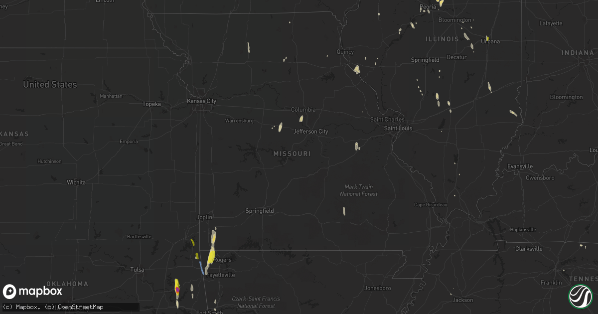
Hail Map in Missouri on May 25, 2020
Get this storm
May 25 map
$229
one time, instant access
Download today. No call, no setup
Keep the $229
Bought the map and want the full workflow? Apply the entire $229 to a subscription within 7 days. None of it is wasted.
Every map, not just this one
This buys you this map. Subscription and you get every map we run, in the markets you choose from a few cities to whole states to nationwide. Plus real-time alerts the moment a storm fires.
Contact data
Name, contact info, occupancy, even credit band for addresses in the footprint. You go from where it hit to who to call.
Become the source they trust
Unlimited branding weather history reports on demand. You already have the documented answer ready for the property owner, and you are the one who showed up with it.
Property data and RoofTrace estimates
Pull up any address you have got, its value and the exact code rules for that jurisdiction, straight from One Click Code. Then RoofTrace estimates the squares, pitch, and roof value, priced the way you price.
Storm reports in Missouri
Missouri
| Date | Description |
|---|---|
| 05/25/20206:06 PM CDT | Delayed report. Brief touchdown of a tornado at the corner of mike road and vernon kennedy avenue near mendon. Some minor structural damage was noted at that location. |
| 05/25/20204:56 PM CDT | Delayed reort. Several tree branches were down in concordia... Along with some minor structural damage. Winds were estimated at 60 to 65 mph. Time estimated from radar. |
| 05/25/20204:40 PM CDT | Delayed report. Large tree limb split near spickard. Public report relayed to the office via broadcast media. |
| 05/25/20204:36 PM CDT | 2 to 3 inch tree limbs down. Reported by amateur radio operator through emergency manager. |
| 05/25/20203:27 PM CDT | Modot employee reports tree down on highway 79 near louisiana. |
| 05/25/20203:03 PM CDT | Spotters for doniphan county ks reported seeing a tornado touch down for a brief minute then went back up. |
| 05/25/20202:56 PM CDT | Modot employee reports tree down over highway k. Time estimated from radar. |
| 05/25/20202:55 PM CDT | Corrects time on previous tornado report from 6 s saint joseph airport. Spotters for doniphan county ks reported seeing a tornado touch down for a brief minute then wen |
| 05/25/20202:39 PM CDT | Buildings damaged... Fencing torn up. |
| 05/25/20202:33 PM CDT | Sheriff deputy reported strong winds that broke trees and a barn. |
| 05/25/20202:30 PM CDT | Delayed report. Nws employee saw tornado several miles north of their location. They noted the time and location was estimated by radar. The tornado likely was brief. |
| 05/25/20206:42 AM CDT | At 1141 PM CDT, severe thunderstorms were located along a line extending from 13 miles northeast of Forsyth to near Taneyville to near Merriam Woods, moving northwest at 50 mph. HAZARD...60 mph wind gusts. SOURCE...Radar indicated. IMPACT...Expect damage to roofs, siding, and trees. Locations impacted include... Nixa... Ozark... Sparta... Highlandville... Fremont Hills... Oldfield... Elkhead... Bruner... Selmore... Keltner... Christian Center... Rome... Garrison... Chadwick... Linden... Goodhope... |
| 05/25/20206:11 AM CDT | At 1111 PM CDT, severe thunderstorms were located along a line extending from near Arkawana to near Price Place to near Ozark Isle to near Lead Hill, moving north at 50 mph. HAZARD...60 mph wind gusts and penny size hail. SOURCE...Radar indicated. IMPACT...Expect damage to roofs, siding, and trees. Locations impacted include... Lake Taneycomo... Bull Shoals Lake... Norfork Lake... Forsyth... Merriam Woods... Kissee Mills... Rockaway Beach... Gainesville... Taneyville... Theodosia... Pontiac... Wasola... Sundown... Brixey... Willhoit... Tecumseh... Powersite... Udall... Hardenville... Protem... |
| 05/25/20205:42 AM CDT | At 1042 PM CDT, severe thunderstorms were located along a line extending from near Culp to Advance to 7 miles northwest of Maumee, moving northwest at 55 mph. HAZARD...60 mph wind gusts. SOURCE...Radar indicated. IMPACT...Expect damage to roofs, siding, and trees. Locations impacted include... Mountain Home... Bull Shoals... Yellville... Gassville... Flippin... Lakeview in Baxter County... Diamond City... Norfork... Salesville... Lead Hill... Briarcliff... Arkawana... Lakeway... Bull Shoals State Park... Herron... Colfax... Advance... Cartney... Culp... Norfork Dam... |
| 05/25/20204:11 AM CDT | At 911 PM CDT, severe thunderstorms were located along a line extending from near Seneca to near Goodman to 8 miles northeast of Pineville to 6 miles northwest of Pea Ridge, moving north at 30 mph. HAZARD...60 mph wind gusts and quarter size hail. SOURCE...Radar indicated. IMPACT...Hail damage to vehicles is expected. Expect wind damage to roofs, siding, and trees. Locations impacted include... Big Sugar Creek State Park... Anderson... Goodman... Pineville... Lanagan... Powell... Rocky Comfort... This includes Interstate 49 between mile markers 1 and 14. |
| 05/25/20204:00 AM CDT | At 859 PM CDT, severe thunderstorms were located along a line extending from near Seneca to near Goodman to near Pineville to 7 miles north of Bella Vista, moving north at 35 mph. HAZARD...60 mph wind gusts and quarter size hail. SOURCE...Radar indicated. IMPACT...Hail damage to vehicles is expected. Expect wind damage to roofs, siding, and trees. Locations impacted include... Neosho... Seneca... Granby... Diamond... Loma Linda... Fairview... Newtonia... Stella... Stark City... Ritchey... Racine... This includes Interstate 49 between mile markers 16 and 31. |
| 05/25/20203:26 AM CDT | At 826 PM CDT, severe thunderstorms were located along a line extending from near Jay to near Gravette to near Hiwasse to Tontitown, moving north at 30 mph. HAZARD...60 mph wind gusts and quarter size hail. SOURCE...Radar indicated. IMPACT...Hail damage to vehicles is expected. Expect wind damage to roofs, siding, and trees. Locations impacted include... Big Sugar Creek State Park... Anderson... Noel... Dodge... Goodman... South West City... Pineville... Lanagan... Powell... Rocky Comfort...This includes Interstate 49 between mile markers 1 and 14. |
| 05/25/20202:30 AM CDT | At 730 PM CDT, a severe thunderstorm was located 7 miles north of Huntsville, moving north at 45 mph. HAZARD...60 mph wind gusts and quarter size hail. SOURCE...Radar indicated. IMPACT...Hail damage to vehicles is expected. Expect wind damage to roofs, siding, and trees. Locations impacted include... Moberly, Macon, Huntsville, Bevier, Atlanta, Callao, Cairo, New Cambria, Jacksonville, Ethel, Excello, Prairie Hill and Wien. |
| 05/25/20201:11 AM CDT | At 610 PM CDT, a severe thunderstorm was located 8 miles north of Puxico, or 12 miles west of Advance, moving north at 30 mph. HAZARD...60 mph wind gusts and nickel size hail. SOURCE...Radar indicated. IMPACT...Expect damage to roofs, siding, and trees. Locations impacted include... Cascade, Grassy and Zalma. |
| 05/25/202012:32 AM CDT | At 531 PM CDT, a severe thunderstorm was located over Barlow, or near La Center, moving northwest at 25 mph. HAZARD...60 mph wind gusts and penny size hail. SOURCE...Radar indicated. IMPACT...Expect damage to roofs, siding, and trees. Locations impacted include... La Center, Barlow, Mound City and Kevil. |
| 05/24/202011:54 PM CDT | At 454 PM CDT, a severe thunderstorm was located 7 miles south of Greencastle, or 14 miles east of Milan, moving north at 35 mph. HAZARD...60 mph wind gusts and nickel size hail. SOURCE...Radar indicated. IMPACT...Expect damage to roofs, siding, and trees. Locations impacted include... Green City, Novinger, Greencastle, Worthington and Green Castle. |
| 05/24/202011:51 PM CDT | At 451 PM CDT, a severe thunderstorm was located near Spickard, or 14 miles north of Trenton, moving north at 40 mph. HAZARD...60 mph wind gusts and nickel size hail. SOURCE...Radar indicated. IMPACT...Expect damage to roofs, siding, and trees. Locations impacted include... Princeton, Mercer, Powersville, South Lineville, Mill Grove and Modena. |
| 05/24/202011:51 PM CDT | Picture of a large tree snapped a few feet up the trunk on hickory drive southwest of ozark missouri. Time estimated from radar. |
| 05/24/202011:44 PM CDT | At 444 PM CDT, severe thunderstorms were located along a line extending from 6 miles north of Knob Noster to near Kingsville, moving north at 40 mph. HAZARD...60 mph wind gusts and nickel size hail. SOURCE...Radar indicated. IMPACT...Expect damage to roofs, siding, and trees. Locations impacted include... Odessa, Higginsville, Lexington, Concordia, Waverly, Orrick, Wellington, Corder, Alma, Henrietta, Blackburn, Mayview, Lake Lafayette, Emma, Napoleon, Bates City, Camden, Fleming, Dover and Aullville.This includes Interstate 70 in Missouri between mile markers 31 and62. |
| 05/24/202011:34 PM CDT | At 434 PM CDT, severe thunderstorms were located along a line extending from near Bevier to 8 miles north of Callao to 13 miles north of Bucklin, moving northeast at 40 mph. HAZARD...60 mph wind gusts and quarter size hail. SOURCE...Radar indicated. IMPACT...Hail damage to vehicles is expected. Expect wind damage to roofs, siding, and trees. Locations impacted include... Kirksville, Macon, La Plata, Bevier, Novinger, Atlanta, Callao, Gibbs, Millard, Elmer, Ethel, South Gifford, Kirksville Regional and New Boston. |
| 05/24/202011:31 PM CDT | At 431 PM CDT, a severe thunderstorm was located near Trenton, moving north at 45 mph. HAZARD...60 mph wind gusts and quarter size hail. SOURCE...Radar indicated. IMPACT...Hail damage to vehicles is expected. Expect wind damage to roofs, siding, and trees. Locations impacted include... Trenton, Princeton, Spickard, Galt, Laredo, Humphreys, Tindall, Harris, Osgood and Mill Grove. |
| 05/24/202010:21 PM CDT | Social media post of a large tree uprooted in northeastern carthage... Mo. |
| 05/24/20209:59 PM CDT | At 259 PM CDT, a severe thunderstorm was located over Davis, moving northwest at 30 mph. HAZARD...60 mph wind gusts and nickel size hail. SOURCE...Radar indicated. IMPACT...Expect damage to roofs, siding, and trees. Locations impacted include... Davis, Silex, Truxton, Whiteside, Cave and Olney. |
| 05/24/20209:58 PM CDT | At 258 PM CDT, a severe thunderstorm was located over Henrietta, or over Richmond, moving north at 35 mph. HAZARD...60 mph wind gusts and nickel size hail. SOURCE...Radar indicated. IMPACT...Expect damage to roofs, siding, and trees. Locations impacted include... Richmond, Lexington, Hardin, Henrietta, Camden and Fleming. |
| 05/24/20209:51 PM CDT | Large tree top snapped off blocking the road. 400 block of south elm st in granby. |
| 05/24/20209:04 PM CDT | Delayed report of a tree down near the intersection of cowan ridge road and gobblers knob road. Time estimated from radar. |
| 05/24/20209:02 PM CDT | Delayed report. A tree was blown down near the intersection of highway k and packet hollow road. Time estimated from radar. |
All States Impacted by Hail Map on May 25, 2020
Cities Impacted by Hail Map on May 25, 2020
- Zapata, TX
- Garciasville, TX
- Guerra, TX
- Grulla, TX
- San Ygnacio, TX
- Rio Grande City, TX
- Roma, TX
- Novice, TX
- Goldsboro, TX
- Coleman, TX
- Granby, MO
- Pineville, MO
- Noel, MO
- Siloam Springs, AR
- Hiwasse, AR
- Bentonville, AR
- Gentry, AR
- Gravette, AR
- Bella Vista, AR
- Stella, MO
- Centerton, AR
- Sulphur Springs, AR
- Summers, AR
- Decatur, AR
- Neosho, MO
- Anderson, MO
- Fayetteville, AR
- Goodman, MO
- Tallassee, TN
- Comstock, TX
- Toledo, IL
- Lerna, IL
- Marathon, TX
- Kingsville, TX
- Hebbronville, TX
- Laredo, TX
- Brantwood, WI
- Ogema, WI
- Tripoli, WI
- Maiden Rock, WI
- Mondovi, WI
- Durand, WI
- Uvalde, TX
- Sabinal, TX
- Knippa, TX
- Pepin, WI
- Freer, TX
- Hamilton, TX
- Champaign, IL
- Chambersburg, IL
- Alma, AR
- Lavaca, AR
- San Antonio, TX
- Leslie, MO
- Sullivan, MO
- Beaufort, MO
- Floresville, TX
- Merkel, TX
- Topeka, IL
- Holcombe, WI
- Cornell, WI
- Lowpoint, IL
- Metamora, IL
- Medford, WI
- Del Rio, TX
- Vonore, TN
- Catarina, TX
- Alice, TX
- Lake City, MN
- Abilene, TX
- Ramsey, IL
- Alpine, TN
- Monroe, TN
- Hermitage, TN
- Mount Juliet, TN
- Realitos, TX
- Nixon, TX
- Stockdale, TX
- Le Roy, IL
- Pearsall, TX
- Batesville, TX
- D Hanis, TX
- Gore, OK
- Vian, OK
- Jay, OK
- Westmoreland, TN
- Cadott, WI
- Sheldon, WI
- Penn Yan, NY
- New Cambria, MO
- Premont, TX
- Concepcion, TX
- Richland Springs, TX
- Rochelle, TX
- Barksdale, TX
- Rocksprings, TX
- Rochester, MN
- Millville, MN
- Winters, TX
- Talpa, TX
- Burdett, NY
- Odessa, NY
- Farmer City, IL
- Weldon, IL
- Wabasha, MN
- Arkansaw, WI
- Stockholm, WI
- Albia, IA
- Hondo, TX
- Eau Claire, WI
- Milladore, WI
- Litchfield, IL
- Troy, MO
- Priddy, TX
- Comanche, TX
- Brackettville, TX
- Spiro, OK
- Elmira, NY
- Big Flats, NY
- Horseheads, NY
- Pine City, NY
- Cheboygan, MI
- Irving, IL
- Tipton, MO
- Pewamo, MI
- Lyons, MI
- Portland, MI
- Elgin, MN
- Sweetwater, TX
- Robert Lee, TX
- Bronte, TX
- Tuscola, TX
- Ovalo, TX
- Bigfoot, TX
- Bunch, OK
- Saint Clair, MO
- Fort Gibson, OK
- Hulbert, OK
- Tahlequah, OK
- Taylorsville, KY
- Eureka, IL
- Roanoke, IL
- Greenup, IL
- Elmendorf, TX
- Wister, OK
- Devine, TX
- Moore, TX
- Yancey, TX
- Eminence, MO
- Lodi, NY
- Manito, IL
- Witt, IL
- Fillmore, IL
- Hillsboro, IL
- Pickerel, WI
- Pearson, WI
- Coffeen, IL
- Sonora, TX
- San Augustine, TX
- Beaver Dams, NY
- Corning, NY
- Elk Mound, WI
- Chippewa Falls, WI
- Jim Falls, WI
- Mulberry Grove, IL
- Keshena, WI
- Havana, IL
- Forest City, IL
- Saybrook, IL
- Roanoke, LA
- Welsh, LA
- Carlyle, IL
- Gleason, WI
- Mico, TX
- La Vernia, TX
- Seguin, TX
- Adkins, TX
- Raymond, IL
- Maryville, TN
- Florence, MO
- San Diego, TX
- Westboro, WI
- Hope, AR
- Syracuse, MO
- Fortuna, MO
- Taylorville, IL
- Enterprise, MS
- Robinson, IL
- Lawrenceville, IL
- Flat Rock, IL
- Ashland, MO
- Columbia, MO
- Hartsburg, MO
- Ethel, MO
- Johnston City, IL
- Putnam, IL
- Morehead, KY
- Clearfield, KY
- Arrowsmith, IL
- Nolan, TX
- Hennepin, IL
- Granville, IL
- Mark, IL
- Chireno, TX
- Springfield, TN
- Colfax, WI
- New Canton, IL
- Kinderhook, IL
- Barry, IL
- Lafayette, TN
- Bement, IL
- Buncombe, IL
- Eau Galle, WI
- Menomonie, WI
- Zumbro Falls, MN
- Girard, IL
- Rudy, AR
- Bunceton, MO
- Gilman, WI
- Lublin, WI
- De Land, IL
- Monticello, IL
- Groveland, IL
- East Peoria, IL
- Pekin, IL
- Creve Coeur, IL
- Mamou, LA
- Vandalia, IL
- Mirando City, TX
- Bloomer, WI
- Good Hope, IL
- Griggsville, IL
- Tomahawk, WI
- Merrill, WI
- Irma, WI
- Karnes City, TX
- Converse, TX
- Saint Hedwig, TX
- Marion, TX
- Centerville, IA
- Cost, TX
- Liberty, IL
- Washburn, IL
- Salt Lick, KY
- Withee, WI
- Queen City, MO
- Philadelphia, MO
- Trent, TX
- Deerbrook, WI
- Deer Creek, IL
- Peoria, IL
- Mullin, TX
- Summit Lake, WI
- Bells, TN
- Humboldt, TN
- Thorp, WI
- Monticello, KY
- Ladysmith, WI
- Albany, KY
- Milton, KY
- Elcho, WI
- Waggoner, IL
- Castroville, TX
- Keota, OK
- Poth, TX
- Benton, IL
- Stilwell, OK
- Downs, IL
- Shobonier, IL
- Llano, TX
- Laredo, MO
- Trenton, MO
- Chula, MO
- Blackwell, TX
- Glen Flora, WI
- Van Buren, AR
- Astoria, IL
- Ipava, IL
- Lewistown, IL
- Hanna City, IL
- Mapleton, IL
- Gustine, TX
- Dilley, TX
- Kenedy, TX
- Nordheim, TX
- Runge, TX
- Fairland, OK
- Wyandotte, OK
- Grove, OK
- Watts, OK
- Colcord, OK
- Pine Valley, NY
- Johnston, IA


