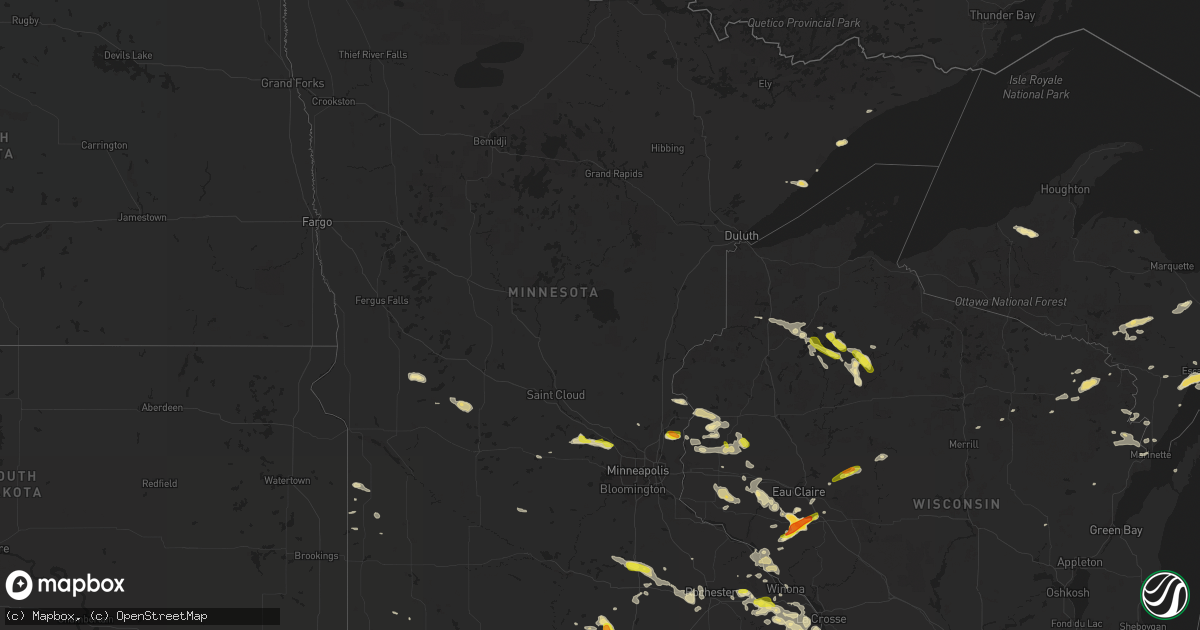
Hail Map in Minnesota on May 25, 2018
Get this storm
May 25 map
$229
one time, instant access
Download today. No call, no setup
Keep the $229
Bought the map and want the full workflow? Apply the entire $229 to a subscription within 7 days. None of it is wasted.
Every map, not just this one
This buys you this map. Subscription and you get every map we run, in the markets you choose from a few cities to whole states to nationwide. Plus real-time alerts the moment a storm fires.
Contact data
Name, contact info, occupancy, even credit band for addresses in the footprint. You go from where it hit to who to call.
Become the source they trust
Unlimited branding weather history reports on demand. You already have the documented answer ready for the property owner, and you are the one who showed up with it.
Property data and RoofTrace estimates
Pull up any address you have got, its value and the exact code rules for that jurisdiction, straight from One Click Code. Then RoofTrace estimates the squares, pitch, and roof value, priced the way you price.
Storm reports in Minnesota
Minnesota
| Date | Description |
|---|---|
| 05/25/20185:40 PM CDT | Numerous trees down and some power lines down between houston and brownsville. |
| 05/25/20185:00 PM CDT | Tree fell on car near 75th and fernbrook. |
| 05/25/20184:45 PM CDT | Corrects previous hail report from st. Michael. |
| 05/25/20184:45 PM CDT | A local report indicates 1.00 inch wind near 2 SSE ROGERS |
| 05/25/20184:00 PM CDT | Reported via twitter. |
| 05/25/20184:00 PM CDT | Reported via twitter... Time estimated. |
| 05/25/20183:36 PM CDT | A local report indicates 1.00 inch wind near LEWISTON |
| 05/25/20183:30 PM CDT | A local report indicates 1.50 inch wind near 2 N ALDEN |
| 05/25/20182:47 PM CDT | Whitewater state park employee said a few hailstones could have been a little bigger. |
| 05/25/20182:40 PM CDT | Landspout tornado touched down briefly. Location is approximate. Photos confirm it touched down. |
| 05/25/20183:53 AM CDT | At 852 PM CDT, severe thunderstorms were located along a line extending from near Eyota to near Dover to near Wykoff, moving east at 35 mph. HAZARD...60 mph wind gusts and penny size hail. SOURCE...Law enforcement. Wind gusts to 60 mph have been reported with these storms. IMPACT...Expect damage to roofs, siding, and trees. Severe thunderstorms will be near... St. Charles around 900 PM CDT. Fountain around 905 PM CDT. Lanesboro around 915 PM CDT. Rushford around 925 PM CDT. Other locations impacted by these severe thunderstorms includeFillmore, Rushford Village, Saratoga, Highland and Hart. |
| 05/25/20183:15 AM CDT | At 815 PM CDT, severe thunderstorms were located along a line extending from near Pine Island to Byron to 7 miles southeast of Kasson, moving east at 30 mph. HAZARD...60 mph wind gusts and nickel size hail. SOURCE...Trained weather spotters. Several reports of wind gusts to 50 mph or greater have been received from northern Dodge County. IMPACT...Expect damage to roofs, siding, and trees. Severe thunderstorms will be near... Rochester, Oronoco and Stewartville around 835 PM CDT. Eyota around 855 PM CDT. Dover and Chatfield around 900 PM CDT. Other locations impacted by these severe thunderstorms includeMarion, High Forest, Pleasant Grove, Douglas and Rock Dell. |
| 05/25/20182:39 AM CDT | At 738 PM CDT, a severe thunderstorm was located near Medford, or 8 miles northeast of Owatonna, moving east at 30 mph. HAZARD...60 mph wind gusts and quarter size hail. SOURCE...Radar indicated. IMPACT...Hail damage to vehicles is expected. Expect wind damage to roofs, siding, and trees. This severe thunderstorm will be near... Claremont around 755 PM CDT. West Concord around 800 PM CDT. Dodge Center around 810 PM CDT. Mantorville around 815 PM CDT. Kasson around 820 PM CDT. Other locations impacted by this severe thunderstorm include Wasioja,Concord, Eden, County Roads 1 And 24 and County Roads 20 And 5. |
| 05/25/20182:32 AM CDT | At 731 PM CDT, severe thunderstorms were located along a line extending from near Elk Mound to 10 miles northwest of Mondovi to near Durand, moving east at 25 mph. HAZARD...60 mph wind gusts and nickel size hail. SOURCE...Radar indicated. IMPACT...Expect damage to roofs, siding, and trees. Severe thunderstorms will be near... Modena around 750 PM CDT. Mondovi around 755 PM CDT. Strum and Osseo around 815 PM CDT. Other locations impacted by these severe thunderstorms include Eleva,Gilmanton, Pigeon Falls, Nelson and Chimney Rock. |
| 05/25/20182:02 AM CDT | At 701 PM CDT, severe thunderstorms were located along a line extending from near Menomonie to near Plum City, moving southeast at 30 mph. HAZARD...60 mph wind gusts and quarter size hail. SOURCE...Radar indicated. IMPACT...Hail damage to vehicles is expected. Expect wind damage to roofs, siding, and trees. Severe thunderstorms will be near, Menomonie around 705 PM CDT. Eau Galle around 720 PM CDT. Elk Mound around 725 PM CDT. Durand around 730 PM CDT. |
| 05/25/20181:06 AM CDT | At 605 PM CDT, a severe thunderstorm was located near New Albin, or near Lansing, moving southeast at 50 mph. HAZARD...60 mph wind gusts and penny size hail. SOURCE...Radar indicated. IMPACT...Expect damage to roofs, siding, and trees. This severe thunderstorm will be near... Lansing around 610 PM CDT. Harpers Ferry around 620 PM CDT. Other locations impacted by this severe thunderstorm include SoldiersGrove, Gays Mills, De Soto, Mount Sterling and Ferryville. |
| 05/25/201812:03 AM CDT | At 503 PM CDT, a severe thunderstorm was located near Scandia, or 24 miles northeast of St. Paul, moving east at 20 mph. HAZARD...60 mph wind gusts and quarter size hail. SOURCE...Radar indicated. IMPACT...Hail damage to vehicles is expected. Expect wind damage to roofs, siding, and trees. This severe thunderstorm will be near, Scandia around 515 PM CDT. Somerset around 535 PM CDT. New Richmond around 550 PM CDT. Star Prairie around 555 PM CDT. Other locations impacted by this severe thunderstorm includeOtisville, Marine On St Croix, Huntington, East Farmington, NewRichmond Airport and William OBrien State Park. |
| 05/24/201811:32 PM CDT | At 431 PM CDT, a severe thunderstorm was located over Buffalo, moving east at 30 mph. HAZARD...60 mph wind gusts and half dollar size hail. SOURCE...Radar indicated. IMPACT...Hail damage to vehicles is expected. Expect wind damage to roofs, siding, and trees. This severe thunderstorm will be near, Albertville and Rockford around 450 PM CDT. St. Michael, Otsego, Rogers, Medina and Independence around 500 PM CDT. Maple Grove and Corcoran around 505 PM CDT. This includes the following highways... Interstate 94 in Minnesota between mile markers 193 and 205. U.S. Highway 12 near mile marker 137. |
| 05/24/201811:24 PM CDT | At 423 PM CDT, a severe thunderstorm was located near Mansfield, or 13 miles southwest of Albert Lea, moving south at 20 mph. HAZARD...60 mph wind gusts and quarter size hail. SOURCE...Radar indicated. IMPACT...Hail damage to vehicles is expected. Expect wind damage to roofs, siding, and trees. This severe thunderstorm will remain over mainly rural areas of southeastern Faribault and southwestern Freeborn Counties, including the following locations: Walters and Kiester. |
| 05/24/201811:12 PM CDT | At 412 PM CDT, a severe thunderstorm was located 7 miles north of Rushford, or 9 miles south of Winona, moving east at 10 mph. HAZARD...Quarter size hail. SOURCE...Radar indicated. IMPACT...Damage to vehicles is expected. this severe thunderstorm will remain over mainly rural areas of south central Winona County, including the following locations: Wilson, Hart, Witoka, I 90 Exit 252 and I 90 Exit 257. |
| 05/24/201811:11 PM CDT | At 410 PM CDT, a severe thunderstorm was located near Emmons, or 12 miles southwest of Albert Lea, moving southeast at 15 mph. HAZARD...60 mph wind gusts and quarter size hail. SOURCE...Radar indicated. IMPACT...Hail damage to vehicles is expected. Expect wind damage to roofs, siding, and trees. Locations impacted include... Northwood, Lake Mills, Emmons, Rice Lake, Carpenter, Scarville, Lake Mills Municipal Airport, Hogsback Wildlife Area, Northwood Municipal and Rice Lake State Park.# # This includes Interstate 35 between mile markers 212 and 218. |
| 05/24/201810:12 PM CDT | At 311 PM CDT, a severe thunderstorm was located over Freeborn, or 11 miles northwest of Albert Lea, moving southeast at 10 mph. HAZARD...60 mph wind gusts and quarter size hail. SOURCE...Radar indicated. IMPACT...Hail damage to vehicles is expected. Expect wind damage to roofs, siding, and trees. This severe thunderstorm will be near, Hartland around 325 PM CDT. Albert Lea and Clarks Grove around 400 PM CDT. Other locations impacted by this severe thunderstorm includeManchester and Albert Lea Airport.This includes the following highways... Interstate 35 between mile markers 7 and 21. Interstate 90 between mile markers 149 and 161. |
| 05/24/20189:55 PM CDT | At 254 PM CDT, a severe thunderstorm was located over Freeborn, or 14 miles northwest of Albert Lea, moving southeast at 20 mph. HAZARD...60 mph wind gusts and quarter size hail. SOURCE...Radar indicated. IMPACT...Hail damage to vehicles is expected. Expect wind damage to roofs, siding, and trees. This severe thunderstorm will be near, Freeborn around 300 PM CDT. Hartland around 310 PM CDT. Albert Lea and Clarks Grove around 335 PM CDT. Other locations impacted by this severe thunderstorm includeManchester, Albert Lea Airport and Matawan.This includes the following highways... Interstate 35 between mile markers 7 and 21. Interstate 90 between mile markers 149 and 161. |
| 05/24/20189:40 PM CDT | At 239 PM CDT, a severe thunderstorm was located near Altura, or 17 miles west of Winona, moving northeast at 35 mph. HAZARD...Quarter size hail. SOURCE...Radar indicated. IMPACT...Damage to vehicles is expected. This severe thunderstorm will be near... Altura and Lewiston around 245 PM CDT. Rollingstone and Stockton around 255 PM CDT. Winona, Fountain City and Goodview around 300 PM CDT. Other locations impacted by this severe thunderstorm include Utica,Minnesota City, Elba, Minneiska and Beaver. |
| 05/24/20189:15 PM CDT | Several reports of trees down across the northeast corner of fillmore county... Especially near rushford. Time estimated from radar. |
| 05/24/20188:53 PM CDT | At 153 PM CDT, a severe thunderstorm was located near Farwell, or 14 miles northeast of Morris, moving southeast at 35 mph. HAZARD...60 mph wind gusts and quarter size hail. SOURCE...Radar indicated. IMPACT...Hail damage to vehicles is expected. Expect wind damage to roofs, siding, and trees. This severe thunderstorm will be near, Starbuck and Lowry around 205 PM CDT. Glenwood around 220 PM CDT. Other locations impacted by this severe thunderstorm include Farwell,Long Beach and Lake Minnewaska. |
| 05/24/20188:31 PM CDT | Rochester international airport official observation. |
| 05/24/20188:00 PM CDT | A few reports of trees and power lines down across the northern half of the county. Time estimated from radar. |
All States Impacted by Hail Map on May 25, 2018
Cities Impacted by Hail Map on May 25, 2018
- Palo Pinto, TX
- Mineral Wells, TX
- Brooten, MN
- Konawa, OK
- Orovada, NV
- Drasco, AR
- Concord, AR
- Mountain View, AR
- Rogersville, MO
- Neelyville, MO
- Tecumseh, OK
- Earlsboro, OK
- Shawnee, OK
- Dardanelle, AR
- Eleva, WI
- New Meadows, ID
- Early, TX
- Mullin, TX
- Zephyr, TX
- Mount Vernon, OR
- Crane, OR
- Burns, OR
- Gladbrook, IA
- Seymour, TX
- Throckmorton, TX
- Rogers, MN
- Hanover, MN
- Richland Springs, TX
- San Saba, TX
- Eau Claire, WI
- Fall Creek, WI
- Waucoma, IA
- Hawkeye, IA
- Ontonagon, MI
- Carmen, ID
- De Leon, TX
- Desdemona, TX
- Dublin, TX
- Abilene, TX
- Lueders, TX
- Union, IA
- Albion, IA
- Liscomb, IA
- Conrad, IA
- Eldora, IA
- Crete, NE
- Junction, TX
- Baker City, OR
- Childress, TX
- Sumner, IA
- Bondurant, IA
- Huxley, IA
- Boone, IA
- Ames, IA
- Elkhart, IA
- Kelley, IA
- Cambridge, IA
- Masonville, IA
- Winthrop, IA
- Russellville, AR
- Northwood, ND
- Gordon, TX
- Montour, IA
- Brush Creek, TN
- Oxford, MS
- Mondovi, WI
- Durand, WI
- Cochrane, WI
- Wadena, IA
- Elgin, IA
- Simpson, IL
- Golconda, IL
- Eddyville, IL
- Forest, MS
- Morton, MS
- Mount Hope, AL
- Russellville, AL
- Clinton, LA
- Cyrus, MN
- Farwell, MN
- Lewisville, AR
- Stamps, AR
- Jena, LA
- Tamms, IL
- Williamsburg, IA
- Marengo, IA
- Eupora, MS
- Orchard, IA
- Osage, IA
- Charles City, IA
- Rudd, IA
- Nora Springs, IA
- Rockford, IA
- Floyd, IA
- Hubbard, IA
- Laceys Spring, AL
- Minong, WI
- Waukon, IA
- Postville, IA
- Decorah, IA
- Mingus, TX
- Stephenville, TX
- Saint Charles, MN
- Herman, NE
- Blair, NE
- Graham, TX
- Houston, MN
- Goodman, WI
- Two Harbors, MN
- Goldthwaite, TX
- Ranger, TX
- Comanche, TX
- Brownwood, TX
- Blanket, TX
- Sidney, TX
- Gorman, TX
- Cherokee, TX
- Willow, OK
- La Crescent, MN
- Stoddard, WI
- Brownsville, MN
- Hokah, MN
- Center Ridge, AR
- Osceola, WI
- Dallas, TX
- Wilmer, TX
- Hutchins, TX
- Stewartville, MN
- Newellton, LA
- Iowa Falls, IA
- Theodosia, MO
- Protem, MO
- Albert Lea, MN
- Hayward, MN
- Austin, MN
- Albany, TX
- Strum, WI
- Eyota, MN
- Rushford, MN
- Winona, MN
- Enid, OK
- Lamont, IA
- Aurora, IA
- Finland, MN
- Silver Bay, MN
- Schroeder, MN
- Council, ID
- Shongaloo, LA
- Solgohachia, AR
- Springfield, AR
- Keota, IA
- North English, IA
- Wellman, IA
- South English, IA
- Hayward, WI
- Winter, WI
- Yorktown, AR
- Vinton, IA
- Cobden, IL
- Anna, IL
- Mason, TX
- Owatonna, MN
- Kellogg, MN
- Altura, MN
- Fountain City, WI
- Alma, WI
- Foster City, MI
- Lindale, TX
- Tyler, TX
- Bradleyville, MO
- Iredell, TX
- Hico, TX
- Carville, LA
- Paducah, TX
- Nisula, MI
- Menomonie, WI
- Freeman, SD
- Steamboat Rock, IA
- Amery, WI
- Glenwood, MN
- Stamford, TX
- Rule, TX
- Wilmont, MN
- Granite, OK
- Lone Wolf, OK
- Marshalltown, IA
- Canby, MN
- Marietta, MN
- Madison, MN
- Wells, MN
- Alden, MN
- Hartland, MN
- Freeborn, MN
- New Richland, MN
- Thorp, WI
- Stanley, WI
- Boyd, WI
- John Day, OR
- Sheridan Lake, CO
- Gore Springs, MS
- Duck Hill, MS
- Jonesville, LA
- Harrisonburg, LA
- Seminole, OK
- Caldwell, ID
- White, SD
- Brookings, SD
- Central City, IA
- Coggon, IA
- Franklin, NE
- Marshfield, MO
- Seymour, MO
- Sparkman, AR
- Couderay, WI
- Caledonia, MN
- Spring Grove, MN
- Seney, MI
- Peshtigo, WI
- Marinette, WI
- Menominee, MI
- Jordan Valley, OR
- Independence, WI
- Dallas Center, IA
- Norway, IA
- Clyde, TX
- Cadott, WI
- Ellsworth, WI
- Beldenville, WI
- River Falls, WI
- Spring Valley, WI
- Baldwin, WI
- Elmwood, WI
- Canadian, TX
- London, AR
- Dover, AR
- Lamar, AR
- Ethel, AR
- De Witt, AR
- Raymond, MS
- Clinton, MS
- Bolton, MS
- Jackson, MS
- Alden, IA
- Moulton, AL
- Big Lake, TX
- Rochelle, TX
- Buffalo, MN
- Maple Lake, MN
- Centuria, WI
- Saint Croix Falls, WI
- Redwood, MS
- Prairie Grove, AR
- Starbuck, MN
- South Shore, SD
- Hendricks, MN
- Wheeler, TX
- Ramer, TN
- Selmer, TN
- Hermosa, SD
- Pontotoc, TX
- Art, TX
- Huntsville, AL
- Owens Cross Roads, AL
- Santo, TX
- Independence, IA
- Enterprise, OR
- Story City, IA
- Mcloud, OK
- Conger, MN
- Emmons, MN
- Belgrade, MN
- Cedar Grove, TN
- Quanah, TX
- Strawn, TX
- Faribault, MN
- Rockwell, IA
- Abbeville, LA
- Youngsville, LA
- Laona, WI
- Swifton, AR
- Alexandria, LA
- Woodworth, LA
- Schuyler, NE
- Clarkson, NE
- Marine On Saint Croix, MN
- Scandia, MN
- Porterfield, WI
- Ledbetter, KY
- Hamburg, AR
- Parnell, IA
- Avoca, TX
- Porter, MN
- Taunton, MN
- Cokato, MN
- Seneca, OR
- Greenleaf, ID
- Melba, ID
- Marsing, ID
- Wilder, ID
- Murphy, ID
- Nampa, ID
- Batesville, AR
- Peterson, MN
- Lewiston, MN
- Utica, MN
- Clear Lake, WI
- Prairie Farm, WI
- Boyceville, WI
- Downing, WI
- Clayton, WI
- New Richmond, WI
- Glenwood City, WI
- Deer Park, WI
- Dover, MN
- Stephenson, MI
- Wausaukee, WI
- Westgate, IA
- Ladora, IA
- Hartwick, IA
- Belle Plaine, IA
- Millersburg, IA
- Harper, IA
- Victor, IA
- Saint Michael, MN
- Marksville, LA
- Leoma, TN
- Albion, NE
- Fordland, MO
- Bruner, MO
- Monticello, MN
- Baird, TX
- Fredonia, TX
- Vicksburg, MS
- Pierce, ID
- Weippe, ID
- Orofino, ID
- Bark River, MI
- Wabeno, WI
- Cedar, MN
- Byron, MN
- Rochester, MN
- Oronoco, MN
- Carter, OK
- Sayre, OK
- Plainview, AR
- Elma, IA
- Cresco, IA
- Kensington, MN
- Dunbar, WI
- Ennis, TX
- Erick, OK
- Vienna, GA
- Byromville, GA
- Mertzon, TX
- Duson, LA
- Rayne, LA
- Scott, LA
- Dresden, KS
- Selden, KS
- Woodville, MS
- Wrightsville, GA
- Mitchellville, IA
- Nevada, IA
- Maxwell, IA
- Montezuma, GA
- Rudyard, MI
- Ojibwa, WI
- Balsam Lake, WI
- Sagola, MI
- Iron Mountain, MI
- Lansing, IA
- Escanaba, MI
- Gladstone, MI
- Haynesville, LA
- Emerson, AR
- Hudson, IA
- Traer, IA
- Buckingham, IA
- Lawler, IA
- Wilson, MI
- Spalding, MI
- Powers, MI
- Summit Lake, WI
- Wauzeka, WI
- Woodman, WI
- Park Falls, WI
- Rapid River, MI
- Clutier, IA
- Dysart, IA
- Taneyville, MO
- Andalusia, AL
- East Moline, IL
- Ellendale, MN
- Hope, MN
- Oklahoma City, OK
- Van Horne, IA
- Garrison, IA
- Newhall, IA
- Walford, IA
- Keystone, IA
- Watkins, IA
- Blairstown, IA
- Amana, IA
- Cedar Rapids, IA
- Fairfax, IA
- Atkins, IA
- Wabasha, MN
- Forest Lake, MN
- Dassel, MN
- Floral, AR
- Roseau, MN
- Hazleton, IA
- Fairbank, IA
- Edgar Springs, MO
- Rolla, MO
- Dickson, TN
- McEwen, TN
- Macomb, OK
- Watertown, SD
- North Fork, ID
- Garden, MI
- Alton, MO
- Thornfield, MO
- Port Gibson, MS
- Hermanville, MS
- Pineville, LA
- Calmar, IA
- Fort Atkinson, IA
- Primrose, NE
- Emery, SD
- Malvern, AR
- Plainview, MN
- Dunkerton, IA
- Ryan, IA
- Dresser, WI
- Silvis, IL
- Owen, WI
- Withee, WI
- Kennard, NE
- Rochester, TX
- Old Glory, TX
- Whitten, IA
- Ackley, IA
- Boscobel, WI
- Winnemucca, NV
- Banks, AL
- Wallace, MI
- Ingalls, MI
- Gibbonsville, ID
- Skandia, MI
- Rock, MI
- Kasson, MN
- Crivitz, WI
- Hattieville, AR
- Mulberry, AR
- Pitkin, LA
- Eastman, WI
- Ozark, MO
- Leola, AR
- Pilot Point, TX
- Huttig, AR
- Taylors Falls, MN
- Center City, MN
- Morristown, MN
- Viroqua, WI
- Horseshoe Bend, ID
- Medford, MN
- Kenyon, MN
- Warsaw, MN
- Fields, OR
- Kamiah, ID
- New Providence, IA
- North Branch, MN
- Osseo, WI
- Pontiac, MO
- Isabella, MO
- Reinbeck, IA
- Dike, IA
- Mass City, MI
- Mobeetie, TX
- Harpers Ferry, IA
- Prairie Du Chien, WI
- Ferryville, WI
- De Soto, WI
- Oakdale, LA
- West Concord, MN
- Waterville, MN
- Kilkenny, MN
- Claremont, MN
- Dodge Center, MN
- Lynchburg, MO
- Augusta, WI
- Danville, AL
- Lancaster, TX
- Knapp, WI
- Prairie City, IA
- Norman, OK
- Noble, OK
- Mangum, OK
- Maple Grove, MN
- Gainesville, MO
- Holly, CO
- Easton, MN
- Breckenridge, TX
- Town Creek, AL
- Leighton, AL
- Minneota, MN
- Summers, AR
- Lincoln, AR
- Michigamme, MI
- Oconto Falls, WI
- Gillett, WI
- Little Lake, MI
- Felch, MI
- Grafton, IA
- Plymouth, IA
- Manly, IA
- Badger, MN
- Hermitage, AR
- Lutsen, MN
- Princeton, OR
- Dows, IA
- Stanley, IA
- Oelwein, IA
- Fence, WI
- Fayetteville, AR
- Maud, OK
- Rogers, NE
- Linwood, NE
- Greensburg, LA
- Hermansville, MI
- Chandler, MN
- Barry, TX
- Tama, IA
- Maynard, IA
- Maiden Rock, WI
- Pine Bluff, AR
- Mccall, ID
- Plainfield, IA
- Waverly, IA
- Strawberry Point, IA
- Arlington, IA
- Manchester, IA
- Oran, IA
- Dundee, IA
- Lexington, TN
- Howells, NE
- El Dorado, AR
- Garwin, IA
- Edgemont, AR
- Clintonville, WI
- Kuna, ID
- Kenefic, OK
- Garrison, MO
- Danville, AR
- O'Brien, TX
- Haskell, TX
- Knox City, TX
- Bald Knob, AR
- Boyce, LA
- Elmer, LA
- Pegram, TN
- Kingston Springs, TN
- Lyle, MN
- Glenville, MN
- Rose Creek, MN
- La Porte City, IA
- Elberon, IA
- Stewart, MS
- Star Prairie, WI
- Gleason, WI
- Somerset, WI
- Calhoun City, MS
- Newalla, OK
- Strong, AR
- Niagara, WI
- Lexington, OK
- Oberlin, KS
- Zumbrota, MN
- Sparta, MO
- Oldfield, MO
- Fayette, IA
- West Union, IA
- Luzerne, IA
- Graford, TX
- Radisson, WI
- Genoa, WI
- Lindstrom, MN
- Ridgeway, IA
- Minburn, IA
- Calico Rock, AR
- Arlington, NE
- Springbrook, WI
- Stone Lake, WI
- Ironside, OR
- Montrose, AR
- Arapahoe, CO
- Whitewright, TX
- Monroe, IA
- Fox, AR
- Dermott, AR
- Elcho, WI
- Rollingstone, MN
- Minnesota City, MN
- Morris, MN
- Andersonville, GA
- Bluff Dale, TX
- Mabel, MN
- Dakota, MN
- Batavia, IA
- Jonesboro, IL
- Rowan, IA
- Saint Gabriel, LA
- White Castle, LA
- Pikeville, KY
- Egg Harbor, WI
- Sturgeon Bay, WI
- Fountain Hill, AR
- Elizabeth, LA
- Florence, WI
- Armstrong Creek, WI
- Ionia, IA
- New Hampton, IA
- Frederika, IA
- Fredericksburg, IA
- Tripoli, IA
- Stewart, MN
- Plush, OR
- Hines, OR
- Adrian, OR
- Joseph, OR
- Imnaha, OR
- Sweet, ID
- Gilbert, IA
- Seagoville, TX
- Briscoe, TX
- Voca, TX
- Twin Lakes, MN
- Phillips, WI


