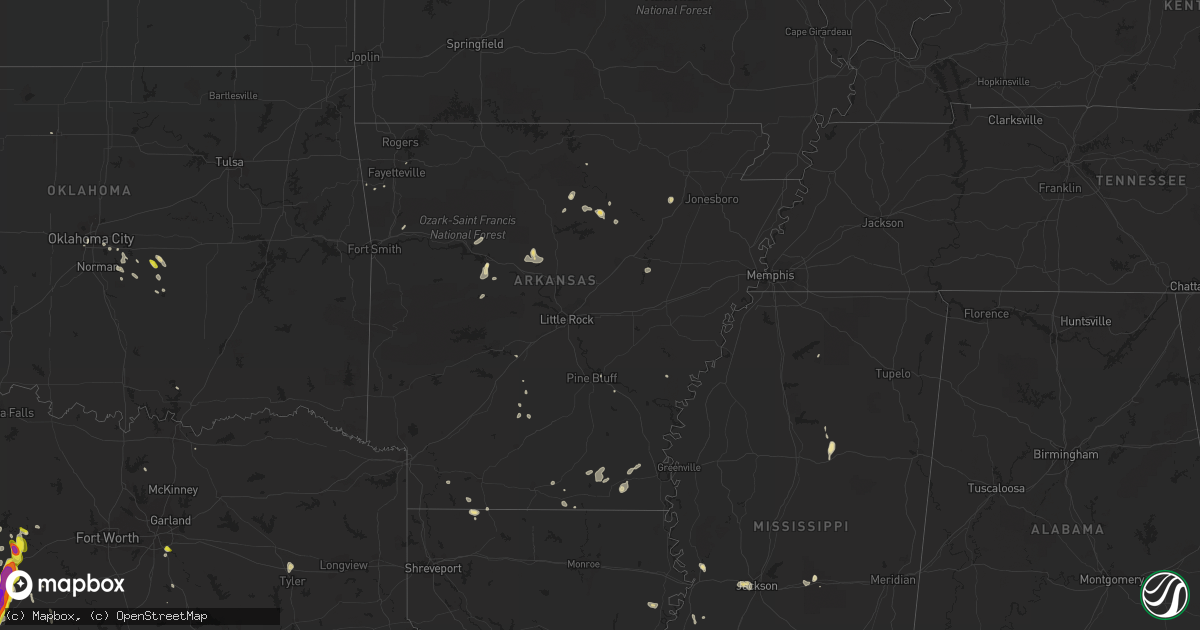
Hail Map in Arkansas on May 25, 2018
Get this storm
May 25 map
$229
one time, instant access
Download today. No call, no setup
Keep the $229
Bought the map and want the full workflow? Apply the entire $229 to a subscription within 7 days. None of it is wasted.
Every map, not just this one
This buys you this map. Subscription and you get every map we run, in the markets you choose from a few cities to whole states to nationwide. Plus real-time alerts the moment a storm fires.
Contact data
Name, contact info, occupancy, even credit band for addresses in the footprint. You go from where it hit to who to call.
Become the source they trust
Unlimited branding weather history reports on demand. You already have the documented answer ready for the property owner, and you are the one who showed up with it.
Property data and RoofTrace estimates
Pull up any address you have got, its value and the exact code rules for that jurisdiction, straight from One Click Code. Then RoofTrace estimates the squares, pitch, and roof value, priced the way you price.
Storm reports in Arkansas
Arkansas
| Date | Description |
|---|---|
| 05/25/20185:39 PM CDT | Tree down on a house in montrose from sub-severe wind gust. Picture received via social media. |
| 05/25/20183:33 PM CDT | Numerous tree limbs down ranging from 3 inch to 6 inch in diameter. Radar time estimated. |
| 05/25/20184:15 AM CDT | At 915 PM CDT, a severe thunderstorm was located over Bethlehem, or 12 miles northeast of Morrilton, moving east at 15 mph. HAZARD...60 mph wind gusts and penny size hail. SOURCE...Radar indicated. IMPACT...Expect damage to roofs, siding, and trees. Locations impacted include... Greenbrier... Wooster... Damascus... Twin Groves... Bethlehem... Lanty... Mallet Town... Solgohachia... Catholic Point... Springfield... Middleton... Birdtown... Martinville... Overcup... |
| 05/25/20182:46 AM CDT | At 746 PM CDT, severe thunderstorms were located along a line extending from Norfork Dam to near Culp, moving east at 20 mph. HAZARD...60 mph wind gusts and nickel size hail. SOURCE...Radar indicated. IMPACT...Expect damage to roofs, siding, and trees. Locations impacted include... Calico Rock... Oxford... Norfork... Salesville... Pineville... Briarcliff... Bexar... Rodney... Norfork Dam... Culp... Wideman... Herron... Gorby... Dolph... Jordan... Wild Cherry... Union... Norfork Lake... |
| 05/25/20182:45 AM CDT | At 745 PM CDT, a severe thunderstorm was located near Petit Jean River WMA, or 9 miles south of Russellville, moving southeast at 20 mph. HAZARD...60 mph wind gusts and quarter size hail. SOURCE...Radar indicated. IMPACT...Hail damage to vehicles is expected. Expect wind damage to roofs, siding, and trees. Locations impacted include... Russellville... Dardanelle... Pottsville... Ola... Petit Jean State Park... Lake Dardanelle State Park... Carden Bottoms... Petit Jean River WMA... Galla Creek WMA... Mosley... Mt Nebo State Park... Lake Dardanelle... Casa... Birta... Lakeview in Yell County... Nimrod... Holla Bend... Mt George... Pontoon... Chickalah... |
| 05/25/20182:14 AM CDT | At 714 PM CDT, a severe thunderstorm was located over Dardanelle, or over Russellville, moving east at 5 mph. HAZARD...60 mph wind gusts and quarter size hail. SOURCE...Radar indicated. IMPACT...Hail damage to vehicles is expected. Expect wind damage to roofs, siding, and trees. Locations impacted include... Russellville... Dardanelle... Atkins... Pottsville... Lake Dardanelle State Park... Carden Bottoms... Galla Creek WMA... Lake Dardanelle... Mt Nebo State Park... Petit Jean State Park... Lakeview in Yell County... Holla Bend... Gum Log... Moreland... |
| 05/25/20182:00 AM CDT | At 659 PM CDT, a severe thunderstorm was located near Moro Bay State Park, or 14 miles east of El Dorado, moving northeast at 15 mph. HAZARD...60 mph wind gusts and quarter size hail. SOURCE...Radar indicated. IMPACT...Hail damage to vehicles is expected. Expect wind damage to roofs, siding, and trees. Locations impacted include... Strong, Lapile, Urbana, Lawson, Moro Bay State Park, New London and Pigeon Hill. |
| 05/25/201812:58 AM CDT | At 557 PM CDT, a severe thunderstorm was located over Springhill, moving southeast at 10 mph. HAZARD...60 mph wind gusts and quarter size hail. SOURCE...Radar indicated. IMPACT...Hail damage to vehicles is expected. Expect wind damage to roofs, siding, and trees. Locations impacted include... Springhill, Haynesville, Cullen, Sarepta, Taylor, Shongaloo, Atlanta, Welcome and Walkerville. |
| 05/25/201812:37 AM CDT | At 536 PM CDT, a severe thunderstorm was located 7 miles northeast of Canfield, or 7 miles south of Lewisville, moving east at 20 mph. HAZARD...60 mph wind gusts and quarter size hail. SOURCE...Radar indicated. IMPACT...Hail damage to vehicles is expected. Expect wind damage to roofs, siding, and trees. Locations impacted include... Magnolia, Stamps, Lewisville, Buckner, Bussey, Canfield, Smithland, Macedonia, Mount Vernon, Lerch, McKamie, Cornelius and Mars Hill. |
| 05/24/201811:27 PM CDT | At 427 PM CDT, a severe thunderstorm was located over Hurricane Lake WMA, or near Augusta, moving east at 15 mph. HAZARD...60 mph wind gusts and quarter size hail. SOURCE...Radar indicated. IMPACT...Hail damage to vehicles is expected. Expect wind damage to roofs, siding, and trees. Locations impacted include... Augusta... Patterson... McCrory... Howell... Wiville... Gregory... Grays... |
| 05/24/201811:24 PM CDT | At 423 PM CDT, severe thunderstorms were located along a line extending from 7 miles north of Fern to 3 miles north of Cass, moving northeast at 25 mph. HAZARD...60 mph wind gusts and nickel size hail. SOURCE...Radar indicated. IMPACT...Expect damage to roofs, siding, and trees. Locations in or near the path include... St. Paul... Saint Paul... Pettigrew... Dutton... Crosses... Patrick... Bidville... Combs... Delaney... Brashears... |
All States Impacted by Hail Map on May 25, 2018
Cities Impacted by Hail Map on May 25, 2018
- Palo Pinto, TX
- Mineral Wells, TX
- Brooten, MN
- Konawa, OK
- Orovada, NV
- Drasco, AR
- Concord, AR
- Mountain View, AR
- Rogersville, MO
- Neelyville, MO
- Tecumseh, OK
- Earlsboro, OK
- Shawnee, OK
- Dardanelle, AR
- Eleva, WI
- New Meadows, ID
- Early, TX
- Mullin, TX
- Zephyr, TX
- Mount Vernon, OR
- Crane, OR
- Burns, OR
- Gladbrook, IA
- Seymour, TX
- Throckmorton, TX
- Rogers, MN
- Hanover, MN
- Richland Springs, TX
- San Saba, TX
- Eau Claire, WI
- Fall Creek, WI
- Waucoma, IA
- Hawkeye, IA
- Ontonagon, MI
- Carmen, ID
- De Leon, TX
- Desdemona, TX
- Dublin, TX
- Abilene, TX
- Lueders, TX
- Union, IA
- Albion, IA
- Liscomb, IA
- Conrad, IA
- Eldora, IA
- Crete, NE
- Junction, TX
- Baker City, OR
- Childress, TX
- Sumner, IA
- Bondurant, IA
- Huxley, IA
- Boone, IA
- Ames, IA
- Elkhart, IA
- Kelley, IA
- Cambridge, IA
- Masonville, IA
- Winthrop, IA
- Russellville, AR
- Northwood, ND
- Gordon, TX
- Montour, IA
- Brush Creek, TN
- Oxford, MS
- Mondovi, WI
- Durand, WI
- Cochrane, WI
- Wadena, IA
- Elgin, IA
- Simpson, IL
- Golconda, IL
- Eddyville, IL
- Forest, MS
- Morton, MS
- Mount Hope, AL
- Russellville, AL
- Clinton, LA
- Cyrus, MN
- Farwell, MN
- Lewisville, AR
- Stamps, AR
- Jena, LA
- Tamms, IL
- Williamsburg, IA
- Marengo, IA
- Eupora, MS
- Orchard, IA
- Osage, IA
- Charles City, IA
- Rudd, IA
- Nora Springs, IA
- Rockford, IA
- Floyd, IA
- Hubbard, IA
- Laceys Spring, AL
- Minong, WI
- Waukon, IA
- Postville, IA
- Decorah, IA
- Mingus, TX
- Stephenville, TX
- Saint Charles, MN
- Herman, NE
- Blair, NE
- Graham, TX
- Houston, MN
- Goodman, WI
- Two Harbors, MN
- Goldthwaite, TX
- Ranger, TX
- Comanche, TX
- Brownwood, TX
- Blanket, TX
- Sidney, TX
- Gorman, TX
- Cherokee, TX
- Willow, OK
- La Crescent, MN
- Stoddard, WI
- Brownsville, MN
- Hokah, MN
- Center Ridge, AR
- Osceola, WI
- Dallas, TX
- Wilmer, TX
- Hutchins, TX
- Stewartville, MN
- Newellton, LA
- Iowa Falls, IA
- Theodosia, MO
- Protem, MO
- Albert Lea, MN
- Hayward, MN
- Austin, MN
- Albany, TX
- Strum, WI
- Eyota, MN
- Rushford, MN
- Winona, MN
- Enid, OK
- Lamont, IA
- Aurora, IA
- Finland, MN
- Silver Bay, MN
- Schroeder, MN
- Council, ID
- Shongaloo, LA
- Solgohachia, AR
- Springfield, AR
- Keota, IA
- North English, IA
- Wellman, IA
- South English, IA
- Hayward, WI
- Winter, WI
- Yorktown, AR
- Vinton, IA
- Cobden, IL
- Anna, IL
- Mason, TX
- Owatonna, MN
- Kellogg, MN
- Altura, MN
- Fountain City, WI
- Alma, WI
- Foster City, MI
- Lindale, TX
- Tyler, TX
- Bradleyville, MO
- Iredell, TX
- Hico, TX
- Carville, LA
- Paducah, TX
- Nisula, MI
- Menomonie, WI
- Freeman, SD
- Steamboat Rock, IA
- Amery, WI
- Glenwood, MN
- Stamford, TX
- Rule, TX
- Wilmont, MN
- Granite, OK
- Lone Wolf, OK
- Marshalltown, IA
- Canby, MN
- Marietta, MN
- Madison, MN
- Wells, MN
- Alden, MN
- Hartland, MN
- Freeborn, MN
- New Richland, MN
- Thorp, WI
- Stanley, WI
- Boyd, WI
- John Day, OR
- Sheridan Lake, CO
- Gore Springs, MS
- Duck Hill, MS
- Jonesville, LA
- Harrisonburg, LA
- Seminole, OK
- Caldwell, ID
- White, SD
- Brookings, SD
- Central City, IA
- Coggon, IA
- Franklin, NE
- Marshfield, MO
- Seymour, MO
- Sparkman, AR
- Couderay, WI
- Caledonia, MN
- Spring Grove, MN
- Seney, MI
- Peshtigo, WI
- Marinette, WI
- Menominee, MI
- Jordan Valley, OR
- Independence, WI
- Dallas Center, IA
- Norway, IA
- Clyde, TX
- Cadott, WI
- Ellsworth, WI
- Beldenville, WI
- River Falls, WI
- Spring Valley, WI
- Baldwin, WI
- Elmwood, WI
- Canadian, TX
- London, AR
- Dover, AR
- Lamar, AR
- Ethel, AR
- De Witt, AR
- Raymond, MS
- Clinton, MS
- Bolton, MS
- Jackson, MS
- Alden, IA
- Moulton, AL
- Big Lake, TX
- Rochelle, TX
- Buffalo, MN
- Maple Lake, MN
- Centuria, WI
- Saint Croix Falls, WI
- Redwood, MS
- Prairie Grove, AR
- Starbuck, MN
- South Shore, SD
- Hendricks, MN
- Wheeler, TX
- Ramer, TN
- Selmer, TN
- Hermosa, SD
- Pontotoc, TX
- Art, TX
- Huntsville, AL
- Owens Cross Roads, AL
- Santo, TX
- Independence, IA
- Enterprise, OR
- Story City, IA
- Mcloud, OK
- Conger, MN
- Emmons, MN
- Belgrade, MN
- Cedar Grove, TN
- Quanah, TX
- Strawn, TX
- Faribault, MN
- Rockwell, IA
- Abbeville, LA
- Youngsville, LA
- Laona, WI
- Swifton, AR
- Alexandria, LA
- Woodworth, LA
- Schuyler, NE
- Clarkson, NE
- Marine On Saint Croix, MN
- Scandia, MN
- Porterfield, WI
- Ledbetter, KY
- Hamburg, AR
- Parnell, IA
- Avoca, TX
- Porter, MN
- Taunton, MN
- Cokato, MN
- Seneca, OR
- Greenleaf, ID
- Melba, ID
- Marsing, ID
- Wilder, ID
- Murphy, ID
- Nampa, ID
- Batesville, AR
- Peterson, MN
- Lewiston, MN
- Utica, MN
- Clear Lake, WI
- Prairie Farm, WI
- Boyceville, WI
- Downing, WI
- Clayton, WI
- New Richmond, WI
- Glenwood City, WI
- Deer Park, WI
- Dover, MN
- Stephenson, MI
- Wausaukee, WI
- Westgate, IA
- Ladora, IA
- Hartwick, IA
- Belle Plaine, IA
- Millersburg, IA
- Harper, IA
- Victor, IA
- Saint Michael, MN
- Marksville, LA
- Leoma, TN
- Albion, NE
- Fordland, MO
- Bruner, MO
- Monticello, MN
- Baird, TX
- Fredonia, TX
- Vicksburg, MS
- Pierce, ID
- Weippe, ID
- Orofino, ID
- Bark River, MI
- Wabeno, WI
- Cedar, MN
- Byron, MN
- Rochester, MN
- Oronoco, MN
- Carter, OK
- Sayre, OK
- Plainview, AR
- Elma, IA
- Cresco, IA
- Kensington, MN
- Dunbar, WI
- Ennis, TX
- Erick, OK
- Vienna, GA
- Byromville, GA
- Mertzon, TX
- Duson, LA
- Rayne, LA
- Scott, LA
- Dresden, KS
- Selden, KS
- Woodville, MS
- Wrightsville, GA
- Mitchellville, IA
- Nevada, IA
- Maxwell, IA
- Montezuma, GA
- Rudyard, MI
- Ojibwa, WI
- Balsam Lake, WI
- Sagola, MI
- Iron Mountain, MI
- Lansing, IA
- Escanaba, MI
- Gladstone, MI
- Haynesville, LA
- Emerson, AR
- Hudson, IA
- Traer, IA
- Buckingham, IA
- Lawler, IA
- Wilson, MI
- Spalding, MI
- Powers, MI
- Summit Lake, WI
- Wauzeka, WI
- Woodman, WI
- Park Falls, WI
- Rapid River, MI
- Clutier, IA
- Dysart, IA
- Taneyville, MO
- Andalusia, AL
- East Moline, IL
- Ellendale, MN
- Hope, MN
- Oklahoma City, OK
- Van Horne, IA
- Garrison, IA
- Newhall, IA
- Walford, IA
- Keystone, IA
- Watkins, IA
- Blairstown, IA
- Amana, IA
- Cedar Rapids, IA
- Fairfax, IA
- Atkins, IA
- Wabasha, MN
- Forest Lake, MN
- Dassel, MN
- Floral, AR
- Roseau, MN
- Hazleton, IA
- Fairbank, IA
- Edgar Springs, MO
- Rolla, MO
- Dickson, TN
- McEwen, TN
- Macomb, OK
- Watertown, SD
- North Fork, ID
- Garden, MI
- Alton, MO
- Thornfield, MO
- Port Gibson, MS
- Hermanville, MS
- Pineville, LA
- Calmar, IA
- Fort Atkinson, IA
- Primrose, NE
- Emery, SD
- Malvern, AR
- Plainview, MN
- Dunkerton, IA
- Ryan, IA
- Dresser, WI
- Silvis, IL
- Owen, WI
- Withee, WI
- Kennard, NE
- Rochester, TX
- Old Glory, TX
- Whitten, IA
- Ackley, IA
- Boscobel, WI
- Winnemucca, NV
- Banks, AL
- Wallace, MI
- Ingalls, MI
- Gibbonsville, ID
- Skandia, MI
- Rock, MI
- Kasson, MN
- Crivitz, WI
- Hattieville, AR
- Mulberry, AR
- Pitkin, LA
- Eastman, WI
- Ozark, MO
- Leola, AR
- Pilot Point, TX
- Huttig, AR
- Taylors Falls, MN
- Center City, MN
- Morristown, MN
- Viroqua, WI
- Horseshoe Bend, ID
- Medford, MN
- Kenyon, MN
- Warsaw, MN
- Fields, OR
- Kamiah, ID
- New Providence, IA
- North Branch, MN
- Osseo, WI
- Pontiac, MO
- Isabella, MO
- Reinbeck, IA
- Dike, IA
- Mass City, MI
- Mobeetie, TX
- Harpers Ferry, IA
- Prairie Du Chien, WI
- Ferryville, WI
- De Soto, WI
- Oakdale, LA
- West Concord, MN
- Waterville, MN
- Kilkenny, MN
- Claremont, MN
- Dodge Center, MN
- Lynchburg, MO
- Augusta, WI
- Danville, AL
- Lancaster, TX
- Knapp, WI
- Prairie City, IA
- Norman, OK
- Noble, OK
- Mangum, OK
- Maple Grove, MN
- Gainesville, MO
- Holly, CO
- Easton, MN
- Breckenridge, TX
- Town Creek, AL
- Leighton, AL
- Minneota, MN
- Summers, AR
- Lincoln, AR
- Michigamme, MI
- Oconto Falls, WI
- Gillett, WI
- Little Lake, MI
- Felch, MI
- Grafton, IA
- Plymouth, IA
- Manly, IA
- Badger, MN
- Hermitage, AR
- Lutsen, MN
- Princeton, OR
- Dows, IA
- Stanley, IA
- Oelwein, IA
- Fence, WI
- Fayetteville, AR
- Maud, OK
- Rogers, NE
- Linwood, NE
- Greensburg, LA
- Hermansville, MI
- Chandler, MN
- Barry, TX
- Tama, IA
- Maynard, IA
- Maiden Rock, WI
- Pine Bluff, AR
- Mccall, ID
- Plainfield, IA
- Waverly, IA
- Strawberry Point, IA
- Arlington, IA
- Manchester, IA
- Oran, IA
- Dundee, IA
- Lexington, TN
- Howells, NE
- El Dorado, AR
- Garwin, IA
- Edgemont, AR
- Clintonville, WI
- Kuna, ID
- Kenefic, OK
- Garrison, MO
- Danville, AR
- O'Brien, TX
- Haskell, TX
- Knox City, TX
- Bald Knob, AR
- Boyce, LA
- Elmer, LA
- Pegram, TN
- Kingston Springs, TN
- Lyle, MN
- Glenville, MN
- Rose Creek, MN
- La Porte City, IA
- Elberon, IA
- Stewart, MS
- Star Prairie, WI
- Gleason, WI
- Somerset, WI
- Calhoun City, MS
- Newalla, OK
- Strong, AR
- Niagara, WI
- Lexington, OK
- Oberlin, KS
- Zumbrota, MN
- Sparta, MO
- Oldfield, MO
- Fayette, IA
- West Union, IA
- Luzerne, IA
- Graford, TX
- Radisson, WI
- Genoa, WI
- Lindstrom, MN
- Ridgeway, IA
- Minburn, IA
- Calico Rock, AR
- Arlington, NE
- Springbrook, WI
- Stone Lake, WI
- Ironside, OR
- Montrose, AR
- Arapahoe, CO
- Whitewright, TX
- Monroe, IA
- Fox, AR
- Dermott, AR
- Elcho, WI
- Rollingstone, MN
- Minnesota City, MN
- Morris, MN
- Andersonville, GA
- Bluff Dale, TX
- Mabel, MN
- Dakota, MN
- Batavia, IA
- Jonesboro, IL
- Rowan, IA
- Saint Gabriel, LA
- White Castle, LA
- Pikeville, KY
- Egg Harbor, WI
- Sturgeon Bay, WI
- Fountain Hill, AR
- Elizabeth, LA
- Florence, WI
- Armstrong Creek, WI
- Ionia, IA
- New Hampton, IA
- Frederika, IA
- Fredericksburg, IA
- Tripoli, IA
- Stewart, MN
- Plush, OR
- Hines, OR
- Adrian, OR
- Joseph, OR
- Imnaha, OR
- Sweet, ID
- Gilbert, IA
- Seagoville, TX
- Briscoe, TX
- Voca, TX
- Twin Lakes, MN
- Phillips, WI


