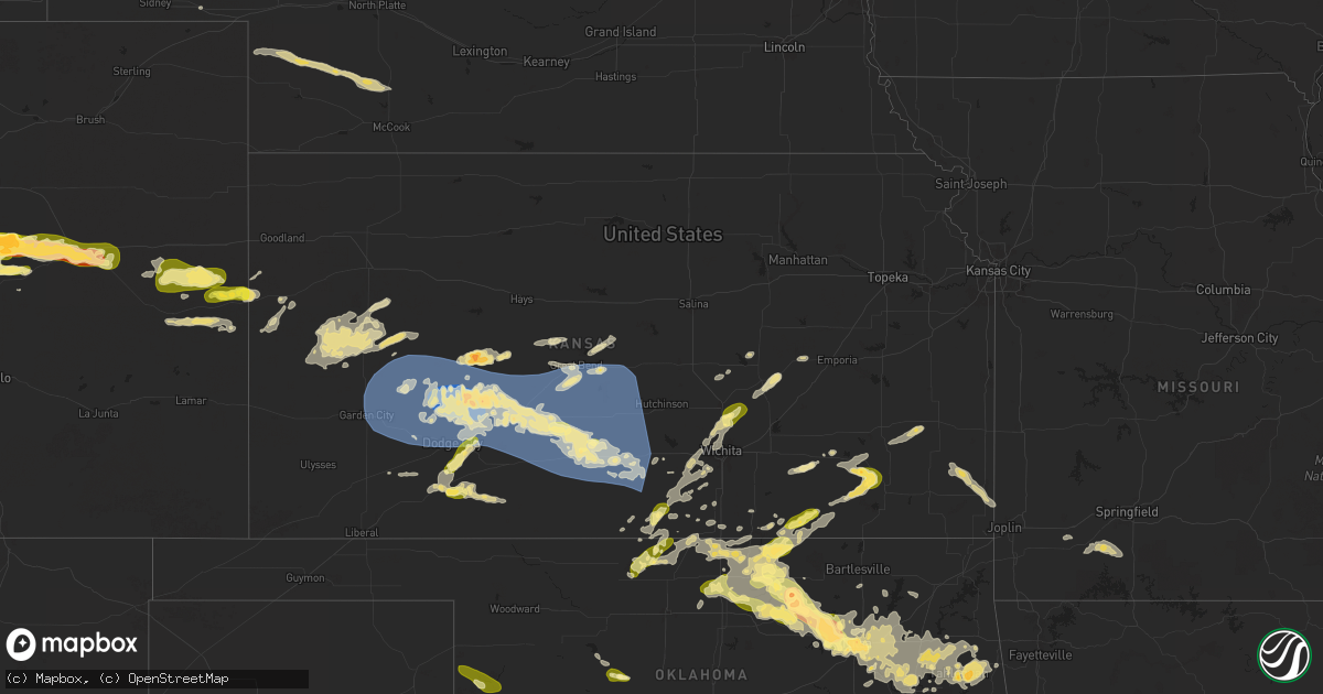
Hail Map in Kansas on May 24, 2025
Get this storm
May 24 map
$229
one time, instant access
Download today. No call, no setup
Keep the $229
Bought the map and want the full workflow? Apply the entire $229 to a subscription within 7 days. None of it is wasted.
Every map, not just this one
This buys you this map. Subscription and you get every map we run, in the markets you choose from a few cities to whole states to nationwide. Plus real-time alerts the moment a storm fires.
Contact data
Name, contact info, occupancy, even credit band for addresses in the footprint. You go from where it hit to who to call.
Become the source they trust
Unlimited branding weather history reports on demand. You already have the documented answer ready for the property owner, and you are the one who showed up with it.
Property data and RoofTrace estimates
Pull up any address you have got, its value and the exact code rules for that jurisdiction, straight from One Click Code. Then RoofTrace estimates the squares, pitch, and roof value, priced the way you price.
Storm reports in Kansas
Kansas
| Date | Description |
|---|---|
| 05/24/20256:57 AM CDT | A local report indicates 1.00 inch wind near 8 S Kingman |
| 05/24/20256:22 AM CDT | Delayed report. |
| 05/24/20256:18 AM CDT | Estimated 60 mph wind northeast of cairo with thunderstorms. Time estimated from radar. |
| 05/24/20256:18 AM CDT | Estimated 60 mph wind northeast of cairo with thunderstorms. Time e |
| 05/24/20256:18 AM CDT | Estimated 60 mph wind north |
| 05/24/20256:18 AM CDT | Estimated 60 mph wind northeast |
| 05/24/20256:18 AM CDT | Estimated 60 mph wind northeast of cairo wit |
| 05/24/20256:15 AM CDT | Ambient weather network site: pratt county landfill. |
| 05/24/20256:07 AM CDT | Public report estimating 60 mph gusts south of pratt. |
| 05/24/20256:05 AM CDT | 67 mph wind gust from a personal weather station. |
| 05/24/20255:26 AM CDT | B-hart-farm. |
| 05/24/20255:16 AM CDT | B-hart-farm. |
| 05/24/20254:58 AM CDT | Corrects previous tstm wnd dmg report from 4 s hanston. Report of 8 to 10 inch tree branches snapped via social media. |
| 05/24/20254:58 AM CDT | Report of 8-10” tree branches snapped via social media. |
| 05/24/20254:45 AM CDT | Kansas state mesonet site hodgeman county. |
| 05/24/20254:44 AM CDT | Pictures via social media show large section of a tree fell onto a house in jetmore with several other large tree branches and a flag pole broken across town. |
| 05/24/20254:44 AM CDT | Pictures via social media show large section of a tr |
| 05/24/20254:43 AM CDT | Shed destroyed via pictures on social media. |
| 05/24/20254:42 AM CDT | Photos on social media show power poles downed east of hodgeman medical center. |
| 05/24/20254:42 AM CDT | Photo via social media shows shed completely destroyed. Time estimated from radar. |
| 05/24/20253:14 AM CDT | A local report indicates 1.00 inch wind near 3 SW Greenbush |
| 05/24/20252:28 AM CDT | A local report indicates 1.00 inch wind near 2 SW Whitewater |
| 05/24/202512:09 AM CDT | A local report indicates 1.00 inch wind near Anthony |
All States Impacted by Hail Map on May 24, 2025
Cities Impacted by Hail Map on May 24, 2025
- Oberlin, KS
- Meeker, OK
- Sparks, OK
- Prague, OK
- Kimball, NE
- Okemah, OK
- Indianola, OK
- Mcalester, OK
- Eufaula, OK
- Dix, NE
- Weleetka, OK
- Wetumka, OK
- Wewoka, OK
- Holdenville, OK
- Potter, NE
- Bayard, NE
- Paden, OK
- Hanna, OK
- Bridgeport, NE
- Henryetta, OK
- Muskogee, OK
- Checotah, OK
- Warner, OK
- Council Hill, OK
- Okmulgee, OK
- Webbers Falls, OK
- Stuart, OK
- Wilburton, OK
- Dustin, OK
- Lamar, OK
- Kiowa, OK
- Savanna, OK
- Blanco, OK
- Krebs, OK
- Hartshorne, OK
- Gurley, NE
- Sidney, NE
- Van Buren, AR
- Alma, AR
- Haileyville, OK
- Quinton, OK
- Conway, AR
- Tuskahoma, OK
- Talihina, OK
- Nashoba, OK
- Snow, OK
- Pittsburg, OK
- Clayton, OK
- Sherwood, AR
- Jacksonville, AR
- Chappell, NE
- Albion, OK
- Bethel, OK
- Honobia, OK
- Whitesboro, OK
- Smithville, OK
- Broken Bow, OK
- Carlisle, AR
- Hazen, AR
- Stuttgart, AR
- De Valls Bluff, AR
- Antlers, OK
- Roe, AR
- Casscoe, AR
- Hugo, OK
- Canadian, OK
- Sawyer, OK
- Fort Towson, OK
- Detroit, TX
- Bagwell, TX
- Stephens, AR
- Greensboro, AL
- Elberta, AL
- Marion, AL
- Marks, MS
- Robertsdale, AL
- Little River, AL
- Newbern, AL
- Strong, AR
- Hermitage, AR
- Fountain Hill, AR
- Hamburg, AR
- Fort Myers, FL
- Monticello, AR
- Montrose, AR
- Repton, AL
- Frisco City, AL
- Laramie, WY
- Dermott, AR
- Uniontown, AL
- Huttig, AR
- Marion, LA
- Crossett, AR
- Bastrop, LA
- Melbourne, FL
- Lucedale, MS
- Fellsmere, FL
- Lake Village, AR
- Portland, AR
- Lehigh Acres, FL
- Greenville, MS
- Parkdale, AR
- Evergreen, AL
- Castleberry, AL
- Malabar, FL
- Palm Bay, FL
- Marion Junction, AL
- Mims, FL
- Titusville, FL
- Lake Wales, FL
- Frostproof, FL
- River Ranch, FL
- Labelle, FL
- Sardis, AL
- Selma, AL
- Brooklyn, MS
- Saint Cloud, FL
- Vero Beach, FL
- Sebastian, FL
- Cocoa, FL
- Deland, FL
- Leakesville, MS
- Alva, FL
- Grant, FL
- Arnaudville, LA
- Carencro, LA
- Kenansville, FL
- Eudora, AR
- Oak Grove, LA
- Citronelle, AL
- Leland, MS
- Elizabeth, CO
- Lake Helen, FL
- Deltona, FL
- McCool, MS
- Louisville, MS
- Jackson, AL
- McKenzie, AL
- Georgiana, AL
- Collinston, LA
- Orrville, AL
- Sidon, MS
- Tyler, AL
- Kiowa, CO
- Oak Ridge, LA
- Noxapater, MS
- Philadelphia, MS
- Isola, MS
- Bunnell, FL
- North Fort Myers, FL
- Myakka City, FL
- Indiantown, FL
- Beaumont, MS
- Lafayette, LA
- Scott, LA
- Anguilla, MS
- Lena, LA
- Yazoo City, MS
- Greenwood, MS
- McLain, MS
- Punta Gorda, FL
- Venango, NE
- Hayneville, AL
- Belzoni, MS
- Monroe, LA
- Pineville, LA
- Colfax, LA
- Loxahatchee, FL
- Ball, LA
- Ona, FL
- Flowood, MS
- Pearl, MS
- West, MS
- Rayne, LA
- Mangham, LA
- Pollock, LA
- Deville, LA
- Castle Rock, CO
- Carrollton, MS
- Port Saint Lucie, FL
- Cloutierville, LA
- Andalusia, AL
- Columbia, LA
- De Leon Springs, FL
- Lowndesboro, AL
- Kissimmee, FL
- Grant, NE
- Coila, MS
- Florien, LA
- Jena, LA
- Daytona Beach, FL
- Elbert, CO
- Sedalia, CO
- Larkspur, CO
- Scooba, MS
- Fort Deposit, AL
- Imperial, NE
- Arcadia, FL
- Madrid, NE
- Winona, MS
- McCarley, MS
- Preston, MS
- Fort Pierce, FL
- Dry Prong, LA
- Benton, MS
- Hope Hull, AL
- Franktown, CO
- Greenville, AL
- Ochopee, FL
- Letohatchee, AL
- Phil Campbell, AL
- Baskin, LA
- Winnsboro, LA
- Elsie, NE
- Wauneta, NE
- Emelle, AL
- Opp, AL
- Kilmichael, MS
- Church Point, LA
- San Augustine, TX
- Newellton, LA
- Vicksburg, MS
- Highland Home, AL
- Lapine, AL
- Hayes Center, NE
- Umatilla, FL
- Altoona, FL
- De Kalb, MS
- Epes, AL
- Gainesville, AL
- Jonesville, LA
- Ethel, MS
- Kosciusko, MS
- Georgetown, LA
- Winter Haven, FL
- Lake Placid, FL
- Hazlehurst, MS
- Avon Park, FL
- Wisner, LA
- Gilbert, LA
- Kenner, LA
- Saint Rose, LA
- Walnut Grove, MS
- Sebring, FL
- Union, MS
- Crystal Springs, MS
- Eustis, FL
- Ferriday, LA
- Harrisonburg, LA
- Clayton, LA
- Eagle Lake, FL
- Brandon, MS
- Forest, MS
- Grady, AL
- Saint Joseph, LA
- Boligee, AL
- Lakeland, FL
- Mulberry, FL
- Wesson, MS
- Eutaw, AL
- Florence, MS
- Colorado Springs, CO
- Monument, CO
- Palmer Lake, CO
- Maywood, NE
- Braxton, MS
- Quitman, MS
- Porterville, MS
- Shuqualak, MS
- Vidalia, LA
- Morton, MS
- Calhan, CO
- Livingston, AL
- Mendenhall, MS
- McCook, NE
- Decatur, MS
- Lorida, FL
- Waterproof, LA
- Conehatta, MS
- Little Rock, MS
- Lorman, MS
- Newton, MS
- Toxey, AL
- Fayette, MS
- Meridian, MS
- Lauderdale, MS
- Natchez, MS
- Hickory, MS
- Rockledge, FL
- Meadville, MS
- Magee, MS
- Chunky, MS
- Gilbertown, AL
- Toomsuba, MS
- Forkland, AL
- Bay Springs, MS
- Butler, AL
- Collinsville, MS
- Gering, NE
- Mitchell, NE
- Scottsbluff, NE
- Minatare, NE
- Mize, MS
- Mount Olive, MS
- Prentiss, MS
- Newhebron, MS
- Collins, MS
- Peyton, CO
- Cuba, AL
- Demopolis, AL
- Marathon, TX
- Hamlin, TX
- McCall Creek, MS
- Roxie, MS
- Bude, MS
- Fort Stockton, TX
- Ralls, TX
- Soso, MS
- Laurel, MS
- Stringer, MS
- Taylorsville, MS
- York, AL
- Ward, AL
- Pine, CO
- Bailey, CO
- Gallion, AL
- Bogue Chitto, MS
- Brookhaven, MS
- Heidelberg, MS
- Bellamy, AL
- Ramah, CO
- Buffalo Creek, CO
- Conifer, CO
- Sumrall, MS
- Columbia, MS
- Goldsmith, TX
- Vossburg, MS
- Crosbyton, TX
- Carson, MS
- Thomasville, AL
- Shubuta, MS
- Pachuta, MS
- Seminary, MS
- Ellisville, MS
- Ruth, MS
- Pennington, AL
- Moselle, MS
- Sweet Water, AL
- Post, TX
- Foxworth, MS
- Linden, AL
- Oak Vale, MS
- Monticello, MS
- Jayess, MS
- Hattiesburg, MS
- Justiceburg, TX
- Andrews, TX
- Campbell, AL
- Dixons Mills, AL
- Odessa, TX
- Dickens, TX
- Spur, TX
- Tarzan, TX
- Coyanosa, TX
- Grandfalls, TX
- Como, CO
- Jefferson, CO
- Monahans, TX
- Millry, AL
- Lamesa, TX
- Lumberton, MS
- Snyder, TX
- Girard, TX
- Paducah, TX
- Crane, TX
- Stanton, TX
- Old Glory, TX
- Frankville, AL
- Chatom, AL
- Wagarville, AL
- Saint Stephens, AL
- Bay Saint Louis, MS
- Kiln, MS
- Gainestown, AL
- Waynesboro, MS
- Purvis, MS
- Imperial, TX
- Bassfield, MS
- Atmore, AL
- Ackerly, TX
- Grove Hill, AL
- Agate, CO
- Simla, CO
- McIntosh, AL
- Gardendale, TX
- Crawford, OK
- Jayton, TX
- Aspermont, TX
- Tahoka, TX
- Odonnell, TX
- Limon, CO
- Matheson, CO
- Lake George, CO
- Arnett, OK
- Durham, OK
- Leedey, OK
- Cheyenne, OK
- Midland, TX
- Seiling, OK
- Longdale, OK
- Guffey, CO
- Florissant, CO
- Canton, OK
- Hammon, OK
- Genoa, CO
- Hugo, CO
- Arriba, CO
- Watonga, OK
- Vernon, TX
- Seymour, TX
- Ponca City, OK
- Seibert, CO
- Flagler, CO
- Harrold, TX
- Hermleigh, TX
- Fairmont, OK
- Garber, OK
- Newkirk, OK
- Kaw City, OK
- Kit Carson, CO
- Vona, CO
- Maple City, KS
- Shidler, OK
- Waldron, KS
- Anthony, KS
- Hunter, OK
- Billings, OK
- Electra, TX
- Rotan, TX
- Grandfield, OK
- Davidson, OK
- Cherokee, OK
- Jet, OK
- Burlington, OK
- Wakita, OK
- Nash, OK
- Manchester, OK
- Tonkawa, OK
- Lamont, OK
- Burbank, OK
- Stratton, CO
- Red Rock, OK
- Burlington, CO
- Cheyenne Wells, CO
- Bethune, CO
- Danville, KS
- Harper, KS
- Freeport, KS
- Medford, OK
- Crowell, TX
- Iowa Park, TX
- Cedar Vale, KS
- Dexter, KS
- Burkburnett, TX
- Devol, OK
- Hazelton, KS
- Kiowa, KS
- Perry, OK
- Ralston, OK
- Fairfax, OK
- Rule, TX
- Arapahoe, CO
- Randlett, OK
- Walters, OK
- Bluff City, KS
- Stamford, TX
- Marland, OK
- Argonia, KS
- Pawnee, OK
- Sedan, KS
- Kinsley, KS
- Milton, KS
- Conway Springs, KS
- Weskan, KS
- Temple, OK
- Lewis, KS
- Caldwell, KS
- Wichita Falls, TX
- Viola, KS
- Garden Plain, KS
- Cheney, KS
- Blackwell, OK
- Spearville, KS
- Hanston, KS
- Belpre, KS
- Larned, KS
- Garfield, KS
- Hominy, OK
- Fowler, KS
- Holliday, TX
- Goddard, KS
- Amorita, OK
- Sharon Springs, KS
- Clearwater, KS
- Arkansas City, KS
- Olney, TX
- Cleveland, OK
- Minneola, KS
- Dodge City, KS
- Macksville, KS
- Byers, KS
- Haviland, KS
- Wichita, KS
- Tribune, KS
- Wallace, KS
- Colwich, KS
- Maize, KS
- Wynona, OK
- Osage, OK
- Wright, KS
- Quanah, TX
- Eldorado, OK
- Elmer, OK
- Chillicothe, TX
- Odell, TX
- Frederick, OK
- Tipton, OK
- Valley Center, KS
- Jetmore, KS
- Howard, KS
- Lawton, OK
- Fort Sill, OK
- Elgin, OK
- Littleton, CO
- Prue, OK
- Maramec, OK
- Skiatook, OK
- Sedgwick, KS
- Elk City, KS
- Longton, KS
- Offerle, KS
- Ford, KS
- Fall River, KS
- St John, KS
- Monett, MO
- Copeland, KS
- Montezuma, KS
- Sand Springs, OK
- Newton, KS
- Whitewater, KS
- Mannford, OK
- Fredonia, KS
- Neodesha, KS
- Headrick, OK
- Altus, OK
- Olustee, OK
- Leoti, KS
- Terlton, OK
- Scott City, KS
- Verona, MO
- Iuka, KS
- Great Bend, KS
- Henrietta, TX
- Ochelata, OK
- Bellevue, TX
- Jennings, OK
- Elbing, KS
- Latham, KS
- Collinsville, OK
- Ramona, OK
- Healy, KS
- Marienthal, KS
- Winona, KS
- Tulsa, OK
- Grinnell, KS
- Owasso, OK
- Sperry, OK
- Talala, OK
- Oologah, OK
- Walnut, KS
- Catoosa, OK
- Broken Arrow, OK
- Mountain Park, OK
- Roosevelt, OK
- Snyder, OK
- Indiahoma, OK
- Medicine Park, OK
- Cache, OK
- Loveland, OK
- Faxon, OK
- Chattanooga, OK
- Geronimo, OK
- Hollister, OK
- Dighton, KS
- Yates Center, KS
- Girard, KS
- Ellinwood, KS
- Piedmont, KS
- Claflin, KS
- Oakley, KS
- Turon, KS
- Braman, OK
- Burns, KS
- Sapulpa, OK
- Florence, KS
- Peabody, KS
- Marionville, MO
- Crane, MO
- Aurora, MO
- Nardin, OK
- Deer Creek, OK
- Humboldt, KS
- Severy, KS
- Bushton, KS
- Chelsea, OK
- Canton, KS
- Moundridge, KS
- Claremore, OK
- McCune, KS
- Wellington, KS
- Protection, KS
- Jenks, OK
- Cedar Point, KS
- Cunningham, KS
- Haysville, KS
- Pittsburg, KS
- Goessel, KS
- Hillsboro, KS
- Holyrood, KS
- Billings, MO
- Bixby, OK
- Inola, OK
- Pryor, OK
- Cherokee, KS
- Garden City, KS
- Iola, KS
- Coweta, OK
- Kingman, KS
- Galena, MO
- Bison, KS
- Marion, KS
- South Haven, KS
- Ponce De Leon, MO
- Spokane, MO
- La Harpe, KS
- Ness City, KS
- Wagoner, OK
- Weir, KS
- Cimarron, KS
- Chouteau, OK
- Otis, KS
- Porter, OK
- Haskell, OK
- Strong City, KS
- Locust Grove, OK
- Bazine, KS
- Taft, OK
- Redbird, OK
- Hoisington, KS
- Asbury, MO
- Hulbert, OK
- Olmitz, KS
- Geuda Springs, KS
- Freistatt, MO
- Rose, OK
- Peggs, OK
- Nekoma, KS
- Alexander, KS
- Tahlequah, OK
- Welling, OK
- Kansas, OK
- Proctor, OK
- Park Hill, OK
- Mounds, OK
- Fort Gibson, OK
- Westville, OK
- Stilwell, OK
- Burdett, KS
- Beeler, KS
- Pierceville, KS
- Ingalls, KS
- Ensign, KS
- Bucklin, KS
- Greensburg, KS
- Rozel, KS
- Mayfield, KS
- Pratt, KS
- Albert, KS
- Pawnee Rock, KS
- Stafford, KS
- Coats, KS
- Sawyer, KS
- Isabel, KS
- Medicine Lodge, KS
- Raymond, KS
- Hudson, KS
- Chase, KS
- Nashville, KS
- Zenda, KS
- Spivey, KS
- Sylvia, KS
- Sterling, KS
- Arlington, KS
- Alden, KS
- Plevna, KS
- Abbyville, KS
- Big Cabin, OK
- Adair, OK
- Winfield, KS
- Watts, OK
- Oxford, KS
- Beggs, OK
- Glenpool, OK
- Partridge, KS
- Pretty Prairie, KS
- Nickerson, KS
- Lyons, KS
- Murdock, KS
- Norwich, KS


