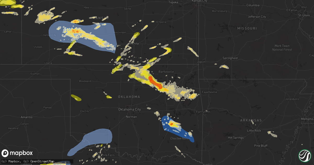
Hail Map on May 24, 2025
Get this storm
May 24 map
$229
one time, instant access
Download today. No call, no setup
Keep the $229
Bought the map and want the full workflow? Apply the entire $229 to a subscription within 7 days. None of it is wasted.
Every map, not just this one
This buys you this map. Subscription and you get every map we run, in the markets you choose from a few cities to whole states to nationwide. Plus real-time alerts the moment a storm fires.
Contact data
Name, contact info, occupancy, even credit band for addresses in the footprint. You go from where it hit to who to call.
Become the source they trust
Unlimited branding weather history reports on demand. You already have the documented answer ready for the property owner, and you are the one who showed up with it.
Property data and RoofTrace estimates
Pull up any address you have got, its value and the exact code rules for that jurisdiction, straight from One Click Code. Then RoofTrace estimates the squares, pitch, and roof value, priced the way you price.
States Impacted by Hail Map on May 24, 2025
Storm reports
Nebraska
| Date | Description |
|---|---|
| 05/24/20255:45 PM CDT | Minor wind damage to roof of kneb radio station building. |
| 05/24/20255:45 PM CDT | A local report indicates 60 MPH wind near Scottsbluff |
Louisiana
| Date | Description |
|---|---|
| 05/24/20255:09 PM CDT | Few trees and powerlines downed near clayton. |
| 05/24/20254:54 PM CDT | Tree downed in sicily island. |
| 05/24/20253:00 PM CDT | Few trees downed across the parish. |
| 05/24/20252:37 PM CDT | Couple of trees reported down in mer rouge. |
Mississippi
| Date | Description |
|---|---|
| 05/24/20256:50 PM CDT | Tree reported across a road in liberty. |
| 05/24/20256:42 PM CDT | Reported on ms hwy 583. |
| 05/24/20256:37 PM CDT | Several trees downed along ms hwy 583 south of brookhaven. |
| 05/24/20256:17 PM CDT | Few trees downed near taylorsville. |
| 05/24/20256:15 PM CDT | Few trees downed around taylorsville. (j |
| 05/24/20256:15 PM CDT | Few trees downed around taylorsville. |
| 05/24/20255:59 PM CDT | Powerlines downed on meadville gloster rd. |
| 05/24/20255:58 PM CDT | A few trees downed around meridian. |
| 05/24/20255:52 PM CDT | Trees downed near fayette. |
| 05/24/20255:46 PM CDT | 62.6 mph wind gust measured along athens road. |
| 05/24/20255:05 PM CDT | Few trees downed in polkville. |
| 05/24/20255:00 PM CDT | Several trees downed across portions of the county. |
| 05/24/20255:00 PM CDT | Several trees downed across the county. |
| 05/24/20254:50 PM CDT | Tree downed at s union rd and lebanon rd. |
| 05/24/20254:38 PM CDT | Tree downed across ms hwy 14. |
| 05/24/20254:33 PM CDT | Multiple branches of a large tree were split along mccool stevenson rd. |
| 05/24/20254:27 PM CDT | Corrects previous tstm wnd dmg report from 5 sse beechwood. Trees and powerline down off of sweetgum lane. |
| 05/24/20254:27 PM CDT | Trees and powerline down off of s\sweetgum lane. |
| 05/24/20254:25 PM CDT | Numerous trees and powerlines reported down across the county. |
| 05/24/20254:00 PM CDT | Few trees downed in durant. |
| 05/24/20253:52 PM CDT | A local report indicates 1.00 inch wind near 1 ENE JAN Airport |
| 05/24/20253:44 PM CDT | Corrects time from previous hail report from jan airport. One inch hail observed at the wfo jackson... Ms office. |
| 05/24/20253:42 PM CDT | One inch hail observed at the wfo jackson... Ms office. |
| 05/24/20253:37 PM CDT | Several trees downed across the county. |
| 05/24/20253:32 PM CDT | A local report indicates 1.00 inch wind near Noxapater |
| 05/24/20253:28 PM CDT | Few trees downed in tchula. |
| 05/24/20253:05 PM CDT | A tree fell on a house and another tree fell on a powerline and caught on fire. Several other trees were also downed across the county. |
| 05/24/20253:05 PM CDT | Several trees down along with a roof blown off of a building. |
| 05/24/20252:37 PM CDT | A couple of trees and powerline downed along highway 1. |
| 05/24/20252:35 PM CDT | Tree limbs downed on augusta street. |
| 05/23/20257:50 PM CDT | Tree in roadway near the intersection of caney church rd and purvis to columbia rd. |
| 05/23/20257:10 PM CDT | Tree in roadway on west hills dr. |
Colorado
| Date | Description |
|---|---|
| 05/24/20256:25 PM CDT | A local report indicates 1.25 inch wind near 4 NE Peyton |
| 05/24/20256:20 PM CDT | A local report indicates 1.00 inch wind near 5 N Peyton |
| 05/24/20255:15 PM CDT | Report from mping: half dollar |
| 05/24/20255:08 PM CDT | A local report indicates 1.25 inch wind near Palmer Lake |
| 05/24/20255:07 PM CDT | A local report indicates 1.00 inch wind near 2 NNE Monument |
| 05/24/20254:50 PM CDT | Report from mping: quarter |
| 05/24/20253:41 PM CDT | Report from mping: hen egg . |
| 05/24/20253:41 PM CDT | Report from mping: hen egg |
| 05/24/20253:24 PM CDT | Report from mping: half dollar |
Kansas
| Date | Description |
|---|---|
| 05/24/20256:57 AM CDT | A local report indicates 1.00 inch wind near 8 S Kingman |
| 05/24/20256:22 AM CDT | Delayed report. |
| 05/24/20256:18 AM CDT | Estimated 60 mph wind northeast of cairo wit |
| 05/24/20256:18 AM CDT | Estimated 60 mph wind northeast of cairo with thunderstorms. Time e |
| 05/24/20256:18 AM CDT | Estimated 60 mph wind north |
| 05/24/20256:18 AM CDT | Estimated 60 mph wind northeast |
| 05/24/20256:18 AM CDT | Estimated 60 mph wind northeast of cairo with thunderstorms. Time estimated from radar. |
| 05/24/20256:15 AM CDT | Ambient weather network site: pratt county landfill. |
| 05/24/20256:07 AM CDT | Public report estimating 60 mph gusts south of pratt. |
| 05/24/20256:05 AM CDT | 67 mph wind gust from a personal weather station. |
| 05/24/20255:26 AM CDT | B-hart-farm. |
| 05/24/20255:16 AM CDT | B-hart-farm. |
| 05/24/20254:58 AM CDT | Corrects previous tstm wnd dmg report from 4 s hanston. Report of 8 to 10 inch tree branches snapped via social media. |
| 05/24/20254:58 AM CDT | Report of 8-10” tree branches snapped via social media. |
| 05/24/20254:45 AM CDT | Kansas state mesonet site hodgeman county. |
| 05/24/20254:44 AM CDT | Pictures via social media show large section of a tree fell onto a house in jetmore with several other large tree branches and a flag pole broken across town. |
| 05/24/20254:44 AM CDT | Pictures via social media show large section of a tr |
| 05/24/20254:43 AM CDT | Shed destroyed via pictures on social media. |
| 05/24/20254:42 AM CDT | Photos on social media show power poles downed east of hodgeman medical center. |
| 05/24/20254:42 AM CDT | Photo via social media shows shed completely destroyed. Time estimated from radar. |
| 05/24/20253:14 AM CDT | A local report indicates 1.00 inch wind near 3 SW Greenbush |
| 05/24/20252:28 AM CDT | A local report indicates 1.00 inch wind near 2 SW Whitewater |
| 05/24/202512:09 AM CDT | A local report indicates 1.00 inch wind near Anthony |
Florida
| Date | Description |
|---|---|
| 05/24/20253:43 PM CDT | Video submitted to local media shows extensive damage to a fence and shed along carlton rd |
| 05/24/20253:32 PM CDT | Image submitted via social media of several hailstones... One of which measuring near 1 inch in diameter. |
| 05/24/20253:15 PM CDT | [landspout] social media image depicts a landspout associated with a thunderstorm ne of canal point. |
| 05/24/20252:52 PM CDT | [delayed] report and subsequent photo indicates quarter size hail fell near adamson creek in cocoa. |
| 05/24/20252:50 PM CDT | Broadcast media relayed viewer-submitted video of hail falling at a residence on 15th street near joel blvd... Estimated up to around 1 inch in diameter. |
| 05/24/20252:46 PM CDT | Delayed report. A member of the public reports half dollar size |
| 05/24/20252:40 PM CDT | Quarter size hail estimated in vero lake estates by trained spotter. |
| 05/24/20252:35 PM CDT | Trained spotter near cogan/san filipo in palm bay estimates 60 mph winds and broken pine tree branches. Also... Reports pea to quarter-size hail. |
| 05/24/20252:32 PM CDT | Updates previous hail report from vero lake estates. Estimated quarter to golf ball size hail based on photos shared by local media in vero lake estates. Hail occurred |
| 05/24/20252:32 PM CDT | Trained spotter estimates hail to quarter size at minds eye observatory |
| 05/24/20252:32 PM CDT | Estimated quarter to golf ball size hail based on photos shared by local media in vero lake estates. |
| 05/24/20252:15 PM CDT | Trained spotter reports quarter-size hail covering ground on windbrook in palm bay. |
| 05/24/20252:12 PM CDT | Reports of large tree branch falling on roof of a home on grandeur st in palm bay. Time est by radar. |
| 05/24/20252:10 PM CDT | Delayed report. A member of the public reports golf ball size |
| 05/24/20252:05 PM CDT | Quarter size hail near grandeur st and emerson dr se in palm bay. |
| 05/24/20252:01 PM CDT | Updates previous hail report from palm bay. Trained spotter reports nickel to half-dollar-size hail in palm bay. Hail lasted 2 to 4 mintues. |
| 05/24/20252:01 PM CDT | Trained spotter reports nickel to quarter-size hail in palm bay. |
Texas
| Date | Description |
|---|---|
| 05/24/20252:30 AM CDT | Mesonet station 59 3nw knox city. Wake low. |
| 05/24/20252:04 AM CDT | Mesonet station 62 wilbarger county texas. Wake low. |
| 05/24/20251:45 AM CDT | Mesonet station 62 wilbarger county texas. Wake low. |
| 05/24/202512:14 AM CDT | A local report indicates 66 MPH wind near Comanche Springs |
| 05/23/202511:10 PM CDT | Mesonet station 31 fluvanna 3w. |
| 05/23/202510:33 PM CDT | Asos station kmaf midland. |
| 05/23/202510:30 PM CDT | Snyder fd reported a broken power pole and flattened hay in a field near fm 1611 north of snyder. This was likely the result of a microburst. Time is estimated from rad |
| 05/23/202510:11 PM CDT | Mesonet station 26 gail 2se. |
| 05/23/202510:02 PM CDT | Measured by ttu mesonet. |
| 05/23/20259:19 PM CDT | Measured by ttu mesonet. |
| 05/23/20259:19 PM CDT | Measured by tt |
| 05/23/20259:00 PM CDT | Mesonet station fw9683 odessa. |
| 05/23/20258:59 PM CDT | Also gusted to 59 mph at 852 pm and 858 pm. Measured by ttu mesonet. |
| 05/23/20258:48 PM CDT | Measured by ttu mesonet. |
| 05/23/20258:16 PM CDT | Lamesa fd/pd reported downed power lines and utility poles. Time estimated by radar. |
| 05/23/20258:13 PM CDT | A local report indicates 71 MPH wind near 2 SSE Lamesa |
| 05/23/20258:05 PM CDT | Measured by ttu mesonet. |
| 05/23/20257:54 PM CDT | [landspout] photograph of landspout tornado reported via x. |
| 05/23/20257:53 PM CDT | Video shows a large amount of hail up to approximately the size of quarters in monahans. Time is estimated from radar. |
| 05/23/20257:50 PM CDT | Public report of a small camper trailer destroyed due to strong winds south of i-20 in monahans. Additionally... Reported a flipped semi-trailer and damage to their veh |
| 05/23/20257:04 PM CDT | Report of quarter size hail and heavy rainfall causing very low visibility along tx 302. Time is estimated from radar. |
Oklahoma
| Date | Description |
|---|---|
| 05/24/20259:29 AM CDT | Bethel fire department reports trees down along us 259 near the triangle. |
| 05/24/20258:05 AM CDT | Report from mping: half dollar |
| 05/24/20258:00 AM CDT | Damage to metal roof. Pictures shared via social media. |
| 05/24/20258:00 AM CDT | Tree damage. |
| 05/24/20258:00 AM CDT | A local report indicates 1.75 inch wind near Mcalester |
| 05/24/20257:57 AM CDT | (ts |
| 05/24/20257:57 AM CDT | A local report indicates 66 MPH wind near 3 SSW Mcalester |
| 05/24/20257:54 AM CDT | 3se stuart mesonet report. |
| 05/24/20257:47 AM CDT | Large tree limb downed. |
| 05/24/20254:35 AM CDT | Awos station kchk chickasha. Wake low. |
| 05/24/20254:20 AM CDT | Mesonet station ftcb fort cobb. Wake low. |
| 05/24/20253:50 AM CDT | Mesonet station acme acme. Wake low. |
| 05/24/20253:45 AM CDT | Mesonet station acme acme. Wake low. |
| 05/24/20253:27 AM CDT | At koki fox |
| 05/24/20253:27 AM CDT | At koki fox23 studios. |
| 05/24/20253:26 AM CDT | Report from mping: quarter |
| 05/24/20253:26 AM CDT | Re |
| 05/24/20253:25 AM CDT | A local report indicates 1.00 inch wind near 2 ESE Tulsa |
| 05/24/20253:18 AM CDT | Report from mping: golf ball |
| 05/24/20253:15 AM CDT | Report from mping: half dollar |
| 05/24/20253:11 AM CDT | Report from mping: half dollar |
| 05/24/20253:10 AM CDT | Mesonet station tipt tipton. Wake low. |
| 05/24/20253:05 AM CDT | Awos station klts altus afb. Wake low. |
| 05/24/20253:03 AM CDT | Report from mping: quarter |
| 05/24/20253:01 AM CDT | A local report indicates 1.00 inch wind near 6 ENE Mannford |
| 05/24/20253:00 AM CDT | 49th west avenue and highway 412. |
| 05/24/20252:59 AM CDT | Report from mping: quarter |
| 05/24/20252:58 AM CDT | Report from mping: quarter |
| 05/24/20252:55 AM CDT | Awos station klts altus afb. Wake low. |
| 05/24/20252:52 AM CDT | Report from mping: ping pong ball |
| 05/24/20252:50 AM CDT | A local report indicates 1.00 inch wind near 6 ENE Mannford |
| 05/24/20252:50 AM CDT | Mesonet station medi medicine park. Wake low. |
| 05/24/20252:50 AM CDT | Mesonet station altu altus. Wake low. |
| 05/24/20252:45 AM CDT | Mesonet station medi medicine park. Wake low. |
| 05/24/20252:35 AM CDT | Mesonet station altu altus. Wake low. |
| 05/24/20252:30 AM CDT | Walters mesonet. Wake low. |
| 05/24/20252:25 AM CDT | Mesonet station altu altus. Wake low. |
| 05/24/20251:40 AM CDT | Awos station kfsi fort sill. Wake low. |
| 05/24/202512:29 AM CDT | Report from mping: quarter |
| 05/24/202512:25 AM CDT | A local report indicates 1.00 inch wind near 1 E Grandfield |
| 05/23/202511:48 PM CDT | Time estimated by radar. |
| 05/23/20259:00 PM CDT | A local report indicates 1.00 inch wind near 7 N Durham |
Arkansas
| Date | Description |
|---|---|
| 05/24/20251:49 PM CDT | Trees and a powerline down in crossett. |
Alabama
| Date | Description |
|---|---|
| 05/24/20256:27 PM CDT | Social media photo of at least quarter size hail. |
| 05/23/20258:35 PM CDT | Large tree blocking both lanes at intersection of allen walker rd and walker springs rd. Time estimated by radar. |
| 05/23/20258:29 PM CDT | Trees down on gainestown rd. Time estimated by radar. |
| 05/23/20258:29 PM CDT | Trees down on forest rd. Time estimated by radar. |
| 05/23/20258:22 PM CDT | Trees blocking both lanes of wiggins rd. Time estimated by radar. |
| 05/23/20258:22 PM CDT | Trees blocking both lanes of wiggins rd. Time estimated by rad |
| 05/23/20257:58 PM CDT | Trees down near peach tree rd and danzy settlement rd. Time estimated by radar. |
Cities Impacted by Hail Map on May 24, 2025
- Oberlin, KS
- Meeker, OK
- Sparks, OK
- Prague, OK
- Kimball, NE
- Okemah, OK
- Indianola, OK
- Mcalester, OK
- Eufaula, OK
- Dix, NE
- Weleetka, OK
- Wetumka, OK
- Wewoka, OK
- Holdenville, OK
- Potter, NE
- Bayard, NE
- Paden, OK
- Hanna, OK
- Bridgeport, NE
- Henryetta, OK
- Muskogee, OK
- Checotah, OK
- Warner, OK
- Council Hill, OK
- Okmulgee, OK
- Webbers Falls, OK
- Stuart, OK
- Wilburton, OK
- Dustin, OK
- Lamar, OK
- Kiowa, OK
- Savanna, OK
- Blanco, OK
- Krebs, OK
- Hartshorne, OK
- Gurley, NE
- Sidney, NE
- Van Buren, AR
- Alma, AR
- Haileyville, OK
- Quinton, OK
- Conway, AR
- Tuskahoma, OK
- Talihina, OK
- Nashoba, OK
- Snow, OK
- Pittsburg, OK
- Clayton, OK
- Sherwood, AR
- Jacksonville, AR
- Chappell, NE
- Albion, OK
- Bethel, OK
- Honobia, OK
- Whitesboro, OK
- Smithville, OK
- Broken Bow, OK
- Carlisle, AR
- Hazen, AR
- Stuttgart, AR
- De Valls Bluff, AR
- Antlers, OK
- Roe, AR
- Casscoe, AR
- Hugo, OK
- Canadian, OK
- Sawyer, OK
- Fort Towson, OK
- Detroit, TX
- Bagwell, TX
- Stephens, AR
- Greensboro, AL
- Elberta, AL
- Marion, AL
- Marks, MS
- Robertsdale, AL
- Little River, AL
- Newbern, AL
- Strong, AR
- Hermitage, AR
- Fountain Hill, AR
- Hamburg, AR
- Fort Myers, FL
- Monticello, AR
- Montrose, AR
- Repton, AL
- Frisco City, AL
- Laramie, WY
- Dermott, AR
- Uniontown, AL
- Huttig, AR
- Marion, LA
- Crossett, AR
- Bastrop, LA
- Melbourne, FL
- Lucedale, MS
- Fellsmere, FL
- Lake Village, AR
- Portland, AR
- Lehigh Acres, FL
- Greenville, MS
- Parkdale, AR
- Evergreen, AL
- Castleberry, AL
- Malabar, FL
- Palm Bay, FL
- Marion Junction, AL
- Mims, FL
- Titusville, FL
- Lake Wales, FL
- Frostproof, FL
- River Ranch, FL
- Labelle, FL
- Sardis, AL
- Selma, AL
- Brooklyn, MS
- Saint Cloud, FL
- Vero Beach, FL
- Sebastian, FL
- Cocoa, FL
- Deland, FL
- Leakesville, MS
- Alva, FL
- Grant, FL
- Arnaudville, LA
- Carencro, LA
- Kenansville, FL
- Eudora, AR
- Oak Grove, LA
- Citronelle, AL
- Leland, MS
- Elizabeth, CO
- Lake Helen, FL
- Deltona, FL
- McCool, MS
- Louisville, MS
- Jackson, AL
- McKenzie, AL
- Georgiana, AL
- Collinston, LA
- Orrville, AL
- Sidon, MS
- Tyler, AL
- Kiowa, CO
- Oak Ridge, LA
- Noxapater, MS
- Philadelphia, MS
- Isola, MS
- Bunnell, FL
- North Fort Myers, FL
- Myakka City, FL
- Indiantown, FL
- Beaumont, MS
- Lafayette, LA
- Scott, LA
- Anguilla, MS
- Lena, LA
- Yazoo City, MS
- Greenwood, MS
- McLain, MS
- Punta Gorda, FL
- Venango, NE
- Hayneville, AL
- Belzoni, MS
- Monroe, LA
- Pineville, LA
- Colfax, LA
- Loxahatchee, FL
- Ball, LA
- Ona, FL
- Flowood, MS
- Pearl, MS
- West, MS
- Rayne, LA
- Mangham, LA
- Pollock, LA
- Deville, LA
- Castle Rock, CO
- Carrollton, MS
- Port Saint Lucie, FL
- Cloutierville, LA
- Andalusia, AL
- Columbia, LA
- De Leon Springs, FL
- Lowndesboro, AL
- Kissimmee, FL
- Grant, NE
- Coila, MS
- Florien, LA
- Jena, LA
- Daytona Beach, FL
- Elbert, CO
- Sedalia, CO
- Larkspur, CO
- Scooba, MS
- Fort Deposit, AL
- Imperial, NE
- Arcadia, FL
- Madrid, NE
- Winona, MS
- McCarley, MS
- Preston, MS
- Fort Pierce, FL
- Dry Prong, LA
- Benton, MS
- Hope Hull, AL
- Franktown, CO
- Greenville, AL
- Ochopee, FL
- Letohatchee, AL
- Phil Campbell, AL
- Baskin, LA
- Winnsboro, LA
- Elsie, NE
- Wauneta, NE
- Emelle, AL
- Opp, AL
- Kilmichael, MS
- Church Point, LA
- San Augustine, TX
- Newellton, LA
- Vicksburg, MS
- Highland Home, AL
- Lapine, AL
- Hayes Center, NE
- Umatilla, FL
- Altoona, FL
- De Kalb, MS
- Epes, AL
- Gainesville, AL
- Jonesville, LA
- Ethel, MS
- Kosciusko, MS
- Georgetown, LA
- Winter Haven, FL
- Lake Placid, FL
- Hazlehurst, MS
- Avon Park, FL
- Wisner, LA
- Gilbert, LA
- Kenner, LA
- Saint Rose, LA
- Walnut Grove, MS
- Sebring, FL
- Union, MS
- Crystal Springs, MS
- Eustis, FL
- Ferriday, LA
- Harrisonburg, LA
- Clayton, LA
- Eagle Lake, FL
- Brandon, MS
- Forest, MS
- Grady, AL
- Saint Joseph, LA
- Boligee, AL
- Lakeland, FL
- Mulberry, FL
- Wesson, MS
- Eutaw, AL
- Florence, MS
- Colorado Springs, CO
- Monument, CO
- Palmer Lake, CO
- Maywood, NE
- Braxton, MS
- Quitman, MS
- Porterville, MS
- Shuqualak, MS
- Vidalia, LA
- Morton, MS
- Calhan, CO
- Livingston, AL
- Mendenhall, MS
- McCook, NE
- Decatur, MS
- Lorida, FL
- Waterproof, LA
- Conehatta, MS
- Little Rock, MS
- Lorman, MS
- Newton, MS
- Toxey, AL
- Fayette, MS
- Meridian, MS
- Lauderdale, MS
- Natchez, MS
- Hickory, MS
- Rockledge, FL
- Meadville, MS
- Magee, MS
- Chunky, MS
- Gilbertown, AL
- Toomsuba, MS
- Forkland, AL
- Bay Springs, MS
- Butler, AL
- Collinsville, MS
- Gering, NE
- Mitchell, NE
- Scottsbluff, NE
- Minatare, NE
- Mize, MS
- Mount Olive, MS
- Prentiss, MS
- Newhebron, MS
- Collins, MS
- Peyton, CO
- Cuba, AL
- Demopolis, AL
- Marathon, TX
- Hamlin, TX
- McCall Creek, MS
- Roxie, MS
- Bude, MS
- Fort Stockton, TX
- Ralls, TX
- Soso, MS
- Laurel, MS
- Stringer, MS
- Taylorsville, MS
- York, AL
- Ward, AL
- Pine, CO
- Bailey, CO
- Gallion, AL
- Bogue Chitto, MS
- Brookhaven, MS
- Heidelberg, MS
- Bellamy, AL
- Ramah, CO
- Buffalo Creek, CO
- Conifer, CO
- Sumrall, MS
- Columbia, MS
- Goldsmith, TX
- Vossburg, MS
- Crosbyton, TX
- Carson, MS
- Thomasville, AL
- Shubuta, MS
- Pachuta, MS
- Seminary, MS
- Ellisville, MS
- Ruth, MS
- Pennington, AL
- Moselle, MS
- Sweet Water, AL
- Post, TX
- Foxworth, MS
- Linden, AL
- Oak Vale, MS
- Monticello, MS
- Jayess, MS
- Hattiesburg, MS
- Justiceburg, TX
- Andrews, TX
- Campbell, AL
- Dixons Mills, AL
- Odessa, TX
- Dickens, TX
- Spur, TX
- Tarzan, TX
- Coyanosa, TX
- Grandfalls, TX
- Como, CO
- Jefferson, CO
- Monahans, TX
- Millry, AL
- Lamesa, TX
- Lumberton, MS
- Snyder, TX
- Girard, TX
- Paducah, TX
- Crane, TX
- Stanton, TX
- Old Glory, TX
- Frankville, AL
- Chatom, AL
- Wagarville, AL
- Saint Stephens, AL
- Bay Saint Louis, MS
- Kiln, MS
- Gainestown, AL
- Waynesboro, MS
- Purvis, MS
- Imperial, TX
- Bassfield, MS
- Atmore, AL
- Ackerly, TX
- Grove Hill, AL
- Agate, CO
- Simla, CO
- McIntosh, AL
- Gardendale, TX
- Crawford, OK
- Jayton, TX
- Aspermont, TX
- Tahoka, TX
- Odonnell, TX
- Limon, CO
- Matheson, CO
- Lake George, CO
- Arnett, OK
- Durham, OK
- Leedey, OK
- Cheyenne, OK
- Midland, TX
- Seiling, OK
- Longdale, OK
- Guffey, CO
- Florissant, CO
- Canton, OK
- Hammon, OK
- Genoa, CO
- Hugo, CO
- Arriba, CO
- Watonga, OK
- Vernon, TX
- Seymour, TX
- Ponca City, OK
- Seibert, CO
- Flagler, CO
- Harrold, TX
- Hermleigh, TX
- Fairmont, OK
- Garber, OK
- Newkirk, OK
- Kaw City, OK
- Kit Carson, CO
- Vona, CO
- Maple City, KS
- Shidler, OK
- Waldron, KS
- Anthony, KS
- Hunter, OK
- Billings, OK
- Electra, TX
- Rotan, TX
- Grandfield, OK
- Davidson, OK
- Cherokee, OK
- Jet, OK
- Burlington, OK
- Wakita, OK
- Nash, OK
- Manchester, OK
- Tonkawa, OK
- Lamont, OK
- Burbank, OK
- Stratton, CO
- Red Rock, OK
- Burlington, CO
- Cheyenne Wells, CO
- Bethune, CO
- Danville, KS
- Harper, KS
- Freeport, KS
- Medford, OK
- Crowell, TX
- Iowa Park, TX
- Cedar Vale, KS
- Dexter, KS
- Burkburnett, TX
- Devol, OK
- Hazelton, KS
- Kiowa, KS
- Perry, OK
- Ralston, OK
- Fairfax, OK
- Rule, TX
- Arapahoe, CO
- Randlett, OK
- Walters, OK
- Bluff City, KS
- Stamford, TX
- Marland, OK
- Argonia, KS
- Pawnee, OK
- Sedan, KS
- Kinsley, KS
- Milton, KS
- Conway Springs, KS
- Weskan, KS
- Temple, OK
- Lewis, KS
- Caldwell, KS
- Wichita Falls, TX
- Viola, KS
- Garden Plain, KS
- Cheney, KS
- Blackwell, OK
- Spearville, KS
- Hanston, KS
- Belpre, KS
- Larned, KS
- Garfield, KS
- Hominy, OK
- Fowler, KS
- Holliday, TX
- Goddard, KS
- Amorita, OK
- Sharon Springs, KS
- Clearwater, KS
- Arkansas City, KS
- Olney, TX
- Cleveland, OK
- Minneola, KS
- Dodge City, KS
- Macksville, KS
- Byers, KS
- Haviland, KS
- Wichita, KS
- Tribune, KS
- Wallace, KS
- Colwich, KS
- Maize, KS
- Wynona, OK
- Osage, OK
- Wright, KS
- Quanah, TX
- Eldorado, OK
- Elmer, OK
- Chillicothe, TX
- Odell, TX
- Frederick, OK
- Tipton, OK
- Valley Center, KS
- Jetmore, KS
- Howard, KS
- Lawton, OK
- Fort Sill, OK
- Elgin, OK
- Littleton, CO
- Prue, OK
- Maramec, OK
- Skiatook, OK
- Sedgwick, KS
- Elk City, KS
- Longton, KS
- Offerle, KS
- Ford, KS
- Fall River, KS
- St John, KS
- Monett, MO
- Copeland, KS
- Montezuma, KS
- Sand Springs, OK
- Newton, KS
- Whitewater, KS
- Mannford, OK
- Fredonia, KS
- Neodesha, KS
- Headrick, OK
- Altus, OK
- Olustee, OK
- Leoti, KS
- Terlton, OK
- Scott City, KS
- Verona, MO
- Iuka, KS
- Great Bend, KS
- Henrietta, TX
- Ochelata, OK
- Bellevue, TX
- Jennings, OK
- Elbing, KS
- Latham, KS
- Collinsville, OK
- Ramona, OK
- Healy, KS
- Marienthal, KS
- Winona, KS
- Tulsa, OK
- Grinnell, KS
- Owasso, OK
- Sperry, OK
- Talala, OK
- Oologah, OK
- Walnut, KS
- Catoosa, OK
- Broken Arrow, OK
- Mountain Park, OK
- Roosevelt, OK
- Snyder, OK
- Indiahoma, OK
- Medicine Park, OK
- Cache, OK
- Loveland, OK
- Faxon, OK
- Chattanooga, OK
- Geronimo, OK
- Hollister, OK
- Dighton, KS
- Yates Center, KS
- Girard, KS
- Ellinwood, KS
- Piedmont, KS
- Claflin, KS
- Oakley, KS
- Turon, KS
- Braman, OK
- Burns, KS
- Sapulpa, OK
- Florence, KS
- Peabody, KS
- Marionville, MO
- Crane, MO
- Aurora, MO
- Nardin, OK
- Deer Creek, OK
- Humboldt, KS
- Severy, KS
- Bushton, KS
- Chelsea, OK
- Canton, KS
- Moundridge, KS
- Claremore, OK
- McCune, KS
- Wellington, KS
- Protection, KS
- Jenks, OK
- Cedar Point, KS
- Cunningham, KS
- Haysville, KS
- Pittsburg, KS
- Goessel, KS
- Hillsboro, KS
- Holyrood, KS
- Billings, MO
- Bixby, OK
- Inola, OK
- Pryor, OK
- Cherokee, KS
- Garden City, KS
- Iola, KS
- Coweta, OK
- Kingman, KS
- Galena, MO
- Bison, KS
- Marion, KS
- South Haven, KS
- Ponce De Leon, MO
- Spokane, MO
- La Harpe, KS
- Ness City, KS
- Wagoner, OK
- Weir, KS
- Cimarron, KS
- Chouteau, OK
- Otis, KS
- Porter, OK
- Haskell, OK
- Strong City, KS
- Locust Grove, OK
- Bazine, KS
- Taft, OK
- Redbird, OK
- Hoisington, KS
- Asbury, MO
- Hulbert, OK
- Olmitz, KS
- Geuda Springs, KS
- Freistatt, MO
- Rose, OK
- Peggs, OK
- Nekoma, KS
- Alexander, KS
- Tahlequah, OK
- Welling, OK
- Kansas, OK
- Proctor, OK
- Park Hill, OK
- Mounds, OK
- Fort Gibson, OK
- Westville, OK
- Stilwell, OK
- Burdett, KS
- Beeler, KS
- Pierceville, KS
- Ingalls, KS
- Ensign, KS
- Bucklin, KS
- Greensburg, KS
- Rozel, KS
- Mayfield, KS
- Pratt, KS
- Albert, KS
- Pawnee Rock, KS
- Stafford, KS
- Coats, KS
- Sawyer, KS
- Isabel, KS
- Medicine Lodge, KS
- Raymond, KS
- Hudson, KS
- Chase, KS
- Nashville, KS
- Zenda, KS
- Spivey, KS
- Sylvia, KS
- Sterling, KS
- Arlington, KS
- Alden, KS
- Plevna, KS
- Abbyville, KS
- Big Cabin, OK
- Adair, OK
- Winfield, KS
- Watts, OK
- Oxford, KS
- Beggs, OK
- Glenpool, OK
- Partridge, KS
- Pretty Prairie, KS
- Nickerson, KS
- Lyons, KS
- Murdock, KS
- Norwich, KS