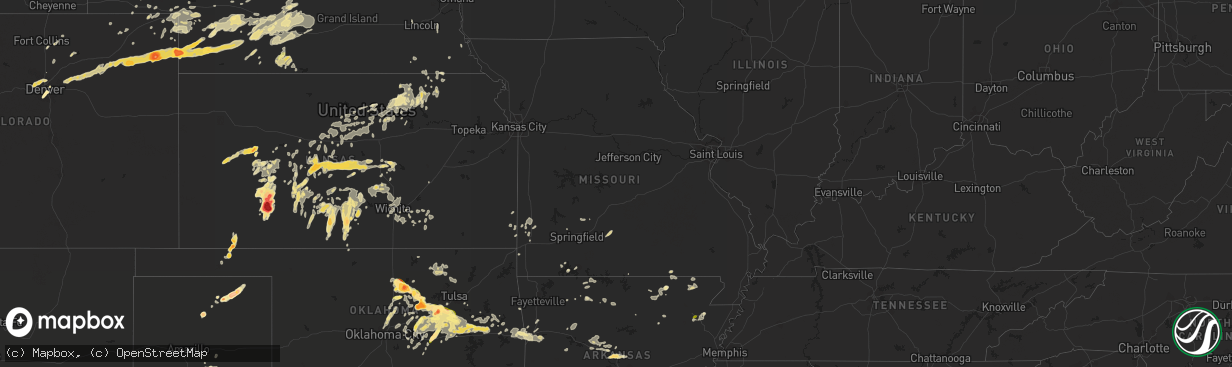
Hail Map in Missouri on May 24, 2016
The weather event in Missouri on May 24, 2016 includes Hail map. 16 states and 685 cities were impacted and suffered possible damage. The total estimated number of properties impacted is 0.
Want more than just the map?
Turn this storm into a full workflow.
- Owner + property data so you know who to knock
- OnDemand branded weather history reports to win the "did we even have hail?" argument
- RoofTrace estimate so reps stop guessing numbers at the door
Bought this map? Upgrade within 7 days and we'll credit the $230. (10-15 min setup call)
Hail
0
Estimated number of impacted properties by a 1.00" hail or larger0
Estimated number of impacted properties by a 1.75" hail or larger0
Estimated number of impacted properties by a 2.50" hail or largerStorm reports in Missouri
Missouri
| Date | Description |
|---|---|
| 05/24/20163:21 PM CDT | Picture of tree down along us highway 17 near lanton. Also pictures of mulitple tree limbs down in lanton area. |
| 05/24/20163:07 PM CDT | Nws survey crew determined intermittent wind damage occurred in a 3/4 - 1 mile swath starting around 1 mile north of south fork and extended east southeast to around ro |
| 05/24/20163:07 PM CDT | Emergency management director reported trees down east of south fork. |
| 05/24/20162:05 PM CDT | Power pole reported down by law enforcement near the intersection of iris rd and goldfinch road. |
| 05/24/20165:42 AM CDT | A local report indicates 1.00 inch wind near 2 N HARTVILLE |
All States Impacted by Hail Map on May 24, 2016
Cities Impacted by Hail Map on May 24, 2016
- Moundridge, KS
- Hesston, KS
- Newton, KS
- Clarksville, AR
- Hanston, KS
- Burdett, KS
- Amorita, OK
- Bertrand, NE
- Edison, NE
- Oxford, NE
- Arapahoe, NE
- Beaver City, NE
- Stamford, NE
- Spivey, KS
- Nashville, KS
- Medicine Lodge, KS
- Kingman, KS
- Turon, KS
- Cunningham, KS
- Arlington, KS
- Attica, KS
- Zenda, KS
- Bristow, OK
- Kellyville, OK
- Beloit, KS
- Leon, KS
- Latham, KS
- Belvidere, SD
- McCracken, KS
- Barnard, KS
- Blue Rapids, KS
- Waterville, KS
- Mounds, OK
- Maramec, OK
- Glencoe, OK
- Drumright, OK
- Boley, OK
- Yale, OK
- Castle, OK
- Cushing, OK
- Depew, OK
- Pawnee, OK
- Sapulpa, OK
- Okmulgee, OK
- Okemah, OK
- Beggs, OK
- Mountain View, AR
- Murdock, KS
- Cheney, KS
- Perry, OK
- Morrison, OK
- Brush, CO
- Perryton, TX
- Yuma, CO
- Wray, CO
- Eckley, CO
- Stillwater, OK
- Vilonia, AR
- Conway, AR
- Wapanucka, OK
- Stewart, MN
- Brownton, MN
- Hutchinson, MN
- Indianola, NE
- Stockville, NE
- Julesburg, CO
- Amherst, CO
- Venango, NE
- Farnam, NE
- Brady, NE
- Gothenburg, NE
- Cozad, NE
- Moorefield, NE
- Willow Island, NE
- Tryon, OK
- Spearman, TX
- Mena, AR
- Pratt, KS
- Iuka, KS
- Harrison, AR
- Western Grove, AR
- Denver, CO
- Aurora, CO
- Prinsburg, MN
- Renville, MN
- Hunter, KS
- Sylvan Grove, KS
- Mills, NE
- Tupelo, OK
- Antlers, OK
- Boswell, OK
- Stringtown, OK
- Snow, OK
- Atoka, OK
- Lane, OK
- Coleman, OK
- Clayton, OK
- Moyers, OK
- Coalgate, OK
- Pawhuska, OK
- Bartlesville, OK
- Sterling, CO
- Hattieville, AR
- Jerusalem, AR
- Solgohachia, AR
- Russellville, AR
- Center Ridge, AR
- Dover, AR
- Atkins, AR
- Hector, AR
- Dexter, IA
- Plumerville, AR
- Lake Lillian, MN
- Kinsley, KS
- Albert, KS
- Otis, KS
- Great Bend, KS
- Sauk Centre, MN
- Byers, KS
- Haigler, NE
- Champion, NE
- Imperial, NE
- Burrton, KS
- Ensign, KS
- Lodgepole, NE
- Morrilton, AR
- Springfield, AR
- Meeker, OK
- Sparks, OK
- Wichita, KS
- Kechi, KS
- Greenwich, KS
- Valley Center, KS
- Benton, KS
- Muldrow, OK
- Van Buren, AR
- Roland, OK
- Bennett, CO
- Kersey, CO
- Broken Arrow, OK
- Murdo, SD
- Draper, SD
- Douglass, KS
- Augusta, KS
- Ness City, KS
- Auburn, NE
- Peru, NE
- Turpin, OK
- Hooker, OK
- Warner, OK
- Checotah, OK
- Oktaha, OK
- Muskogee, OK
- Norman, AR
- Caddo Gap, AR
- Clay Center, KS
- Kearney, NE
- Loomis, NE
- Smithfield, NE
- Overton, NE
- Elm Creek, NE
- Marenisco, MI
- Bruce Crossing, MI
- Watersmeet, MI
- Rattan, OK
- Broken Bow, OK
- Buhler, KS
- Garfield, KS
- Mercer, WI
- Manitowish Waters, WI
- Hurley, WI
- Iron Belt, WI
- Jetmore, KS
- Chandler, OK
- Davenport, OK
- Stroud, OK
- Royalton, MN
- Holdingford, MN
- Bowlus, MN
- Beaumont, KS
- Vian, OK
- Englewood, CO
- Littleton, CO
- Lewis, KS
- Shawnee, OK
- Wessington Springs, SD
- Gann Valley, SD
- Guthrie, OK
- Coyle, OK
- Ontonagon, MI
- Bergland, MI
- Miltona, MN
- Carlos, MN
- Long Prairie, MN
- Eagle Bend, MN
- Hector, MN
- Buffalo Lake, MN
- Lead Hill, AR
- Yellville, AR
- Belle Plaine, MN
- Henderson, MN
- Red Rock, OK
- Ainsworth, NE
- Kimberling City, MO
- Gillette, WY
- Kaycee, WY
- Rozel, KS
- Lucerne, CO
- Eaton, CO
- Greeley, CO
- Glencoe, MN
- Akron, CO
- Cushing, MN
- Motley, MN
- Parkston, SD
- Sumner, NE
- Midland, SD
- Westminster, CO
- Arvada, CO
- Golden, CO
- Broomfield, CO
- Henderson, CO
- Sedgwick, CO
- Crook, CO
- Kerkhoven, MN
- Umpire, AR
- Hutchinson, KS
- Partridge, KS
- Pretty Prairie, KS
- Wallace, NE
- Hoisington, KS
- Claflin, KS
- Canton, KS
- Durham, KS
- Lehigh, KS
- Couch, MO
- Damascus, AR
- Elwood, NE
- Chappell, NE
- Longville, MN
- Pine River, MN
- Backus, MN
- Cimarron, KS
- Wright, KS
- Dodge City, KS
- Greenfield, IA
- Fontanelle, IA
- Agra, OK
- Carney, OK
- Arnold, NE
- Coweta, OK
- Edmond, OK
- Hugoton, KS
- Kismet, KS
- Liberal, KS
- Eddyville, NE
- Amherst, NE
- Miller, NE
- Lexington, NE
- Pleasanton, NE
- Eustis, NE
- Riverdale, NE
- Atlanta, KS
- Osmond, NE
- Butte, NE
- Naper, NE
- Atkinson, NE
- Bonesteel, SD
- Claude, TX
- Halstead, KS
- Sedgwick, KS
- Haven, KS
- Mount Hope, KS
- Remer, MN
- Stinnett, TX
- Home, KS
- Beattie, KS
- Pequot Lakes, MN
- Fowler, KS
- Minneola, KS
- Merino, CO
- Dannebrog, NE
- Kadoka, SD
- Clifton, KS
- Morganville, KS
- Lyons, KS
- Chase, KS
- Ellinwood, KS
- Bushton, KS
- Fort Gibson, OK
- Haviland, KS
- Sterling, KS
- Enders, NE
- Otis, CO
- Olmitz, KS
- Little River, KS
- Roxbury, KS
- Lindsborg, KS
- Marquette, KS
- Geneseo, KS
- Galva, KS
- Bison, KS
- Pawnee Rock, KS
- Mcpherson, KS
- Rush Center, KS
- Larned, KS
- Windom, KS
- Edgemont, SD
- Green Isle, MN
- Lake City, KS
- Sawyer, KS
- Arlington, MN
- Hamburg, MN
- Plato, MN
- Lavaca, AR
- Charleston, AR
- Hays, KS
- Hayes Center, NE
- Brewster, NE
- Ovid, CO
- Springview, NE
- Bethel, OK
- Nashoba, OK
- Half Way, MO
- Fair Grove, MO
- Elkland, MO
- Buffalo, MO
- Ravenden, AR
- Williford, AR
- Hardy, AR
- Alma, NE
- Orleans, NE
- Fairfax, SD
- Holyoke, CO
- Wellston, OK
- Crow Agency, MT
- Palmer, KS
- Elsie, NE
- Peach Orchard, AR
- Biggers, AR
- Corning, AR
- Ogallala, NE
- Brule, NE
- Grant, NE
- Madrid, NE
- Big Springs, NE
- Pierce, NE
- Dalton, NE
- Ash Flat, AR
- Greenleaf, KS
- Beeler, KS
- Casey, IA
- Menlo, IA
- Willard, MO
- Walnut Grove, MO
- Henryetta, OK
- Johnstown, NE
- North Platte, NE
- Scott City, KS
- Barnsdall, OK
- Kyle, SD
- Manderson, SD
- Porcupine, SD
- Pine Ridge, SD
- Tescott, KS
- Salina, KS
- Clyde, KS
- Green, KS
- Greensburg, KS
- Borger, TX
- Randolph, KS
- Parks, NE
- Stafford, KS
- Dighton, KS
- Healy, KS
- Gove, KS
- Quinter, KS
- Evening Shade, AR
- Benkelman, NE
- Wakefield, KS
- Mountainburg, AR
- Mulberry, AR
- Alma, AR
- Burke, SD
- Vermillion, KS
- Frankfort, KS
- Boelus, NE
- Ravenna, NE
- Gibbon, NE
- Odessa, NE
- Hazard, NE
- Curtis, NE
- Rockville, NE
- Cairo, NE
- Hardin, MT
- Cambridge, NE
- Bartley, NE
- Harrah, OK
- Mcloud, OK
- Winterset, IA
- New Sharon, IA
- Fort Smith, AR
- Mullen, NE
- Byers, CO
- Wiggins, CO
- Fort Morgan, CO
- Strasburg, CO
- Council Hill, OK
- Boynton, OK
- Morris, OK
- Broken Bow, NE
- Oconto, NE
- Omaha, AR
- Paris, AR
- Lincoln, KS
- Windsor, CO
- Caney, OK
- Pittsburg, OK
- Caddo, OK
- Finley, OK
- Daisy, OK
- Milburn, OK
- Wanblee, SD
- Hagarville, AR
- Palisade, NE
- Wauneta, NE
- Sharon, KS
- Hazelton, KS
- Ashton, NE
- Cord, AR
- Newark, AR
- Carthage, MO
- Saint Paul, NE
- Wellfleet, NE
- Knoxville, IA
- Kennebec, SD
- Smithville, OK
- Dickens, NE
- St John, KS
- Seminole, OK
- McCook, NE
- Maywood, NE
- Hartville, MO
- Mansfield, MO
- Caulfield, MO
- Bakersfield, MO
- Presho, SD
- Wewoka, OK
- Haskell, OK
- Weleetka, OK
- Ripley, OK
- Billings, OK
- Jennings, OK
- Prague, OK
- Webbers Falls, OK
- Paden, OK
- Lusk, WY
- Okaton, SD
- Gregory, SD
- Harriet, AR
- Avon, MN
- Sidney, NE
- Mission, SD
- Humboldt, NE
- Table Rock, NE
- Elk Creek, NE
- Ellsworth, KS
- Shell Knob, MO
- Lampe, MO
- Porter, OK
- Pella, IA
- Leighton, IA
- Ault, CO
- Pennock, MN
- Magness, AR
- Mason City, NE
- Niagara, WI
- Marienthal, KS
- Fort Pierre, SD
- Mulhall, OK
- Orlando, OK
- Hillsboro, KS
- Gypsum, KS
- Maud, OK
- Greenbrier, AR
- Stapleton, NE
- Aurora, MO
- Jonesboro, AR
- Lake City, AR
- Watson, OK
- Skiatook, OK
- Pocahontas, AR
- Myrtle, MO
- Salem, SD
- Spencer, SD
- Tecumseh, OK
- Massena, IA
- Rock, KS
- Long Valley, SD
- Paoli, CO
- Haxtun, CO
- Concordia, KS
- Clarissa, MN
- Abbyville, KS
- Plevna, KS
- Sylvia, KS
- Cumberland, IA
- Blomkest, MN
- Olivia, MN
- Bird Island, MN
- Oskaloosa, IA
- Allen, SD
- Winfred, SD
- Hodgen, OK
- Randolph, UT
- Cedarville, AR
- Chester, AR
- Rudy, AR
- Bay, AR
- Wynona, OK
- Delphos, KS
- Wilmore, KS
- Oklahoma City, OK
- Meadow Grove, NE
- Hot Springs, SD
- Buffalo Gap, SD
- Ransom, KS
- Barnes, KS
- Miltonvale, KS
- Victoria, KS
- Glasco, KS
- Minneapolis, KS
- Pleasant Dale, NE
- Lincoln, NE
- Malcolm, NE
- Saint Joe, AR
- Huntsville, AR
- Kingston, AR
- Berryville, AR
- Morrowville, KS
- Russell, KS
- Axtell, KS
- Pierz, MN
- Earlsboro, OK
- Offerle, KS
- Bunker Hill, KS
- Pittsburg, KS
- Opolis, KS
- Macksville, KS
- Fullerton, NE
- Cambridge, KS
- Baileyville, KS
- Burchard, NE
- Pawnee City, NE
- Derby, KS
- Rose Hill, KS
- Ansley, NE
- Wickes, AR
- Wilson, KS
- Beverly, KS
- Albany, MN
- Fort Lupton, CO
- Platteville, CO
- Branson, MO
- Everton, AR
- Brownell, KS
- Linn, KS
- Perkins, OK
- Merriman, NE
- Earlham, IA
- Van Meter, IA
- Beatrice, NE
- Summerfield, KS
- Oelrichs, SD
- Lamar, MO
- Jasper, MO
- Liberal, MO
- Tahlequah, OK
- Luray, KS
- Waldo, KS
- Lucas, KS
- Willmar, MN
- Lamar, AR
- Ozone, AR
- Wymore, NE
- Oketo, KS
- Westerville, NE
- Melrose, IA
- Westville, OK
- Lincoln, AR
- Iliff, CO
- Olsburg, KS
- Piedmont, KS
- Stuart, IA
- Compton, AR
- Park Hill, OK
- Belpre, KS
- Palmer, NE
- Archer, NE
- Saint Libory, NE
- Grenola, KS
- Poughkeepsie, AR
- Mullinville, KS
- Nekoma, KS
- Alexander, KS
- Hanover, KS
- Washington, KS
- Marysville, KS
- Leonardville, KS
- Taft, OK
- Gore, OK
- Alden, KS
- Arcadia, KS
- Arma, KS
- Grannis, AR
- Bigelow, AR
- Udall, KS
- Mulvane, KS
- Solomon, KS
- Bennington, KS
- Longford, KS
- Harrold, SD
- Colome, SD
- Bazine, KS
- Martin, SD
- Pembine, WI
- Kingsford, MI
- Cookson, OK
- Waldron, KS
- Heavener, OK
- Cove, AR
- Hatfield, AR
- Vandervoort, AR
- Kilgore, NE
- Kaw City, OK
- Shidler, OK
- Manville, WY
- Oronogo, MO
- Asbury, MO
- Unadilla, NE
- Elmwood, NE
- Palmyra, NE
- Maxwell, NE
- Sallisaw, OK
- Hudson, KS
- Warm Springs, AR
- Canova, SD
- Wood Lake, NE
- Cape Fair, MO
- Tripp, SD
- Upson, WI
- Presque Isle, WI
- Brighton, CO
- Frostproof, FL
- Golden City, MO
- Ellis, KS
- Gans, OK
- Uniontown, AR
- Haysville, KS
- Clearwater, KS
- Jones, OK
- Luther, OK
- Matfield Green, KS
- Success, AR
- Galena, KS
- Carl Junction, MO
- Weir, KS
- Gurley, NE
- Sutherland, NE
- Neosho, MO
- Seneca, MO
- Jansen, NE
- Clarendon, TX
- Miami, TX
- Booker, TX
- Wayside, TX
- Sublette, KS
- Satanta, KS
- Plains, KS
- Miami, FL
- Evergreen, CO
- Watkins, CO
- Woodrow, CO
- Danube, MN
- Sacred Heart, MN


