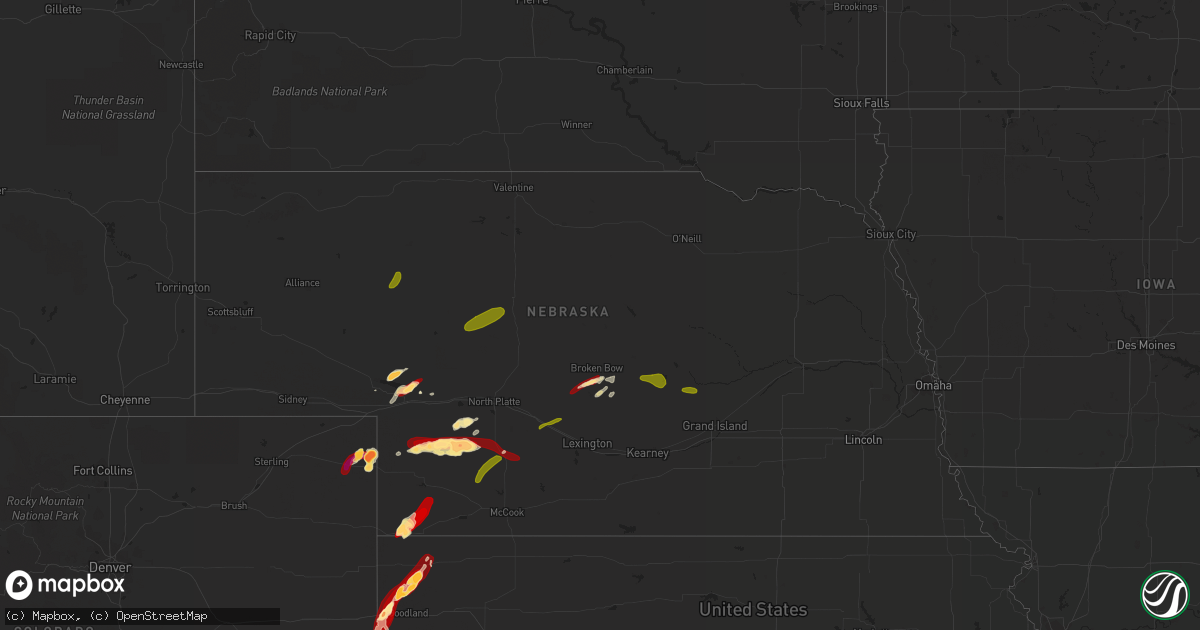
Hail Map in Nebraska on May 24, 2013
Get this storm
May 24 map
$229
one time, instant access
Download today. No call, no setup
Keep the $229
Bought the map and want the full workflow? Apply the entire $229 to a subscription within 7 days. None of it is wasted.
Every map, not just this one
This buys you this map. Subscription and you get every map we run, in the markets you choose from a few cities to whole states to nationwide. Plus real-time alerts the moment a storm fires.
Contact data
Name, contact info, occupancy, even credit band for addresses in the footprint. You go from where it hit to who to call.
Become the source they trust
Unlimited branding weather history reports on demand. You already have the documented answer ready for the property owner, and you are the one who showed up with it.
Property data and RoofTrace estimates
Pull up any address you have got, its value and the exact code rules for that jurisdiction, straight from One Click Code. Then RoofTrace estimates the squares, pitch, and roof value, priced the way you price.
Storm reports in Nebraska
Nebraska
| Date | Description |
|---|---|
| 05/24/20136:55 PM CDT | A local report indicates 1.75 inch wind near 12 W BENKELMAN |
| 05/24/20133:24 AM CDT | A local report indicates 1.50 inch wind near 11 S BROKEN BOW |
| 05/24/201312:15 AM CDT | Quarter size hail reported around 1215 am. |
| 05/24/201312:08 AM CDT | A local report indicates 58 MPH wind near MCCOOK |
| 05/24/201312:00 AM CDT | A local report indicates 1.00 inch wind near 1 NW ROCKVILLE |
| 05/23/201311:31 PM CDT | A local report indicates 1.00 inch wind near GOTHENBURG |
| 05/23/201311:30 PM CDT | Tree damage and power outages in loup city |
| 05/23/201310:45 PM CDT | Car windows were broken from golf ball size hail and slightly larger stones. A possible funnel cloud was also spotted. |
| 05/23/20139:47 PM CDT | A local report indicates 1.75 inch wind near 3 S GRAINTON |
| 05/23/20139:36 PM CDT | A local report indicates 1.75 inch wind near 10 S ELSIE |
| 05/23/20139:02 PM CDT | A local report indicates 1.00 inch wind near 8 S MADRID |
| 05/23/20138:45 PM CDT | It hailed for 5 minutes. |
| 05/23/20138:36 PM CDT | A local report indicates 1.75 inch wind near 6 N WALLACE |
| 05/23/20138:36 PM CDT | A local report indicates 2.00 inch wind near 7 NW LEMOYNE |
| 05/23/20138:21 PM CDT | A local report indicates 1.00 inch wind near 8 S GRANT |
| 05/23/20138:04 PM CDT | A local report indicates 1.75 inch wind near 4 NNW KINGSLEY DAM |
| 05/23/20137:58 PM CDT | A local report indicates 1.75 inch wind near 2 NW KEYSTONE |
| 05/23/20137:21 PM CDT | A local report indicates 1.00 inch wind near 6 NW OGALLALA |
| 05/23/20137:05 PM CDT | A local report indicates 1.75 inch wind near 2 W PARKS |
| 05/23/20137:04 PM CDT | A local report indicates 1.25 inch wind near VENANGO |
Cities Impacted by Hail Map on May 24, 2013
- Dickens, NE
- Wallace, NE
- Callaway, NE
- Broken Bow, NE
- Goodland, KS
- Kanorado, KS
- Saint Francis, KS
- Bird City, KS
- Amherst, CO
- Holyoke, CO
- Ansley, NE
- Oconto, NE
- Ogallala, NE
- Cheyenne, OK
- Haigler, NE
- Parks, NE
- Keystone, NE
- Lemoyne, NE
- Maywood, NE
- Lewellen, NE
- Arapahoe, CO
- Raton, NM
- Big Springs, NE
- Loup City, NE
- Benkelman, NE
- Elsie, NE
- Paxton, NE
- Imperial, NE
- Hayes Center, NE
- Madrid, NE
- Grant, NE
- Grenville, NM
- Venango, NE
- Rio Grande City, TX
- Wellfleet, NE
- Julesburg, CO
- Burlington, CO
- Brule, NE
- Henderson, NE
- Grafton, NE
- York, NE
- Curtis, NE
- Brady, NE
- Moorefield, NE
- Gladstone, NM
- Farwell, NE
- Weskan, KS
- Haxtun, CO
- Paoli, CO
- Gothenburg, NE
- Cozad, NE
- Litchfield, NE
- Arcadia, NE
- Saint Paul, NE
- Tryon, NE
- Mullen, NE
- Seneca, NE
- Thedford, NE
- Merriman, NE
- Hyannis, NE
- Ashby, NE
- Arnett, OK
- Crawford, OK
- Sayre, OK


