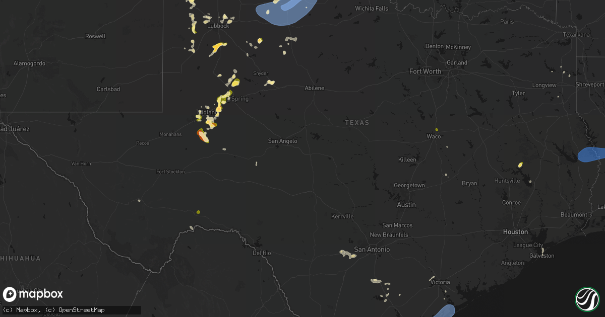
Hail Map in Texas on May 23, 2026
Get this storm
May 23 map
$229
one time, instant access
Download today. No call, no setup
Keep the $229
Bought the map and want the full workflow? Apply the entire $229 to a subscription within 7 days. None of it is wasted.
Every map, not just this one
This buys you this map. Subscription and you get every map we run, in the markets you choose from a few cities to whole states to nationwide. Plus real-time alerts the moment a storm fires.
Contact data
Name, contact info, occupancy, even credit band for addresses in the footprint. You go from where it hit to who to call.
Become the source they trust
Unlimited branding weather history reports on demand. You already have the documented answer ready for the property owner, and you are the one who showed up with it.
Property data and RoofTrace estimates
Pull up any address you have got, its value and the exact code rules for that jurisdiction, straight from One Click Code. Then RoofTrace estimates the squares, pitch, and roof value, priced the way you price.
Storm reports in Texas
Texas
| Date | Description |
|---|---|
| 05/23/20265:50 PM CDT | A local report indicates 1.75 inch wind near 2 WSW Stanton |
| 05/23/20265:41 PM CDT | A local report indicates 1.00 inch wind near Stanton |
| 05/23/20265:12 PM CDT | Corrects previous hail report from 2 wsw stanton. |
| 05/23/20265:06 PM CDT | A local report indicates 1.00 inch wind near 8 SE Midland Internatio |
| 05/23/20263:15 PM CDT | Wind damage to a lowes. |
| 05/23/20261:27 PM CDT | Pictures of large tree down onto a residents home and vehicles. Time estimated by radar. |
| 05/23/202612:45 PM CDT | Several trees down throughout the city. |
| 05/23/202612:10 PM CDT | Large trees down due to thunderstorm wind gusts. |
| 05/23/202612:05 PM CDT | Awos station kngp c. Christi nas. |
| 05/23/202611:56 AM CDT | Picture of one large tree trunk on a v-shape trunk tree snapped/split. |
| 05/23/202611:54 AM CDT | Asos station kcrp corpus christi. |
| 05/23/20269:25 AM CDT | Several trees down on highway 87 between yellowpine and six mile. |
| 05/23/20269:25 AM CDT | Report of numerous trees down or damaged in the south toledo bend area... Particularly near tx 255 and tx 87. Time estimated by radar. |
| 05/23/20269:20 AM CDT | Several trees down on highway 96 between bronson and pineland. |
| 05/23/20269:20 AM CDT | Several trees down on fm 1 between pineland and rosevine. |
| 05/23/20269:07 AM CDT | Tree down on fm 705 between broaddus and bronson. |
| 05/23/20269:07 AM CDT | Report of widespread damage in the west and northwest portions of jasper... Tx. Report of roofs with damage... Trees down... Power lines down. Time estimated by damage. |
| 05/23/20269:03 AM CDT | Photo of damage to large yucca tree. Time estimated by radar. |
| 05/23/20267:40 AM CDT | Photo received of downed tree in fannett. Time estimated by radar. |
| 05/23/20267:21 AM CDT | Report of a tree down in the scottsville area around fm 1998 and cr 2213 east of marshall. |
| 05/23/202612:19 AM CDT | Measured by the west texas mesonet. Severe gusts also occurred at 12:18 and 12:20 am. |
| 05/22/202611:59 PM CDT | Measured by the west texas mesonet. |
| 05/22/202611:57 PM CDT | Measured by the west texas mesonet. Additional severe gusts occurred from 11:56 pm to 12:05 am on 5/24/2026. |
| 05/22/202611:41 PM CDT | Measured by the west texas mesonet. Severe gusts from 58 to 61 mph occurred from 11:36 pm to 11:41 pm. |
| 05/22/202611:34 PM CDT | Measured by the west texas mesonet. |
| 05/22/202611:09 PM CDT | Measured by the west texas mesonet. An additional gust to 64 mph occurred at 11:08 pm. |
| 05/22/20269:06 PM CDT | [landspout] media relayed photo of a landspout in or near levelland. |
| 05/22/20269:04 PM CDT | Hail varying in size from 1/4 inch to 1 inch in levelland. |
| 05/22/20268:55 PM CDT | A local report indicates 58 MPH wind near 2 N Spearman |
| 05/22/20268:50 PM CDT | Spotter reported 1.5 to 2 inch diameter hail currently falling. Spotter was located on highway 380 west of tahoka. Location was estimated by radar. |
| 05/22/20268:40 PM CDT | Reported about 1.5 miles east of tstc. |
| 05/22/20268:21 PM CDT | Mesonet had a gust of 58 mph at 2021cdt with increasing gust to 75 mph at 2023cdt. |
| 05/22/20267:53 PM CDT | A local report indicates 63 MPH wind near 2 N Stinnett |
| 05/22/20267:48 PM CDT | A local report indicates 58 MPH wind near 2 WNW Fritch |
| 05/22/20267:28 PM CDT | [landspout] brief landspout lasted about 3 minutes. Located approximately 5 miles to the northwest of chaser location. Location estimated. |
| 05/22/20267:15 PM CDT | A local report indicates 59 MPH wind near 9 NNE Sunray |
| 05/22/20267:06 PM CDT | A local report indicates 69 MPH wind near 3 SE Dumas |
All States Impacted by Hail Map on May 23, 2026
Cities Impacted by Hail Map on May 23, 2026
- Beckville, TX
- Jefferson, TX
- Livingston, TX
- Cedar Key, FL
- Hondo, TX
- Karnack, TX
- Castroville, TX
- Devine, TX
- La Coste, TX
- Natalia, TX
- Abbeville, LA
- Fulton, AR
- Ogden, AR
- Westlake, LA
- Lake Charles, LA
- Brookeland, TX
- Pineland, TX
- Wiergate, TX
- Hemphill, TX
- Burkeville, TX
- Ragley, LA
- Iowa, LA
- Deridder, LA
- Bell City, LA
- Hornbeck, LA
- Anacoco, LA
- Florien, LA
- Leesville, LA
- Pitkin, LA
- Pleasanton, TX
- Christine, TX
- Jourdanton, TX
- Slagle, LA
- San Diego, TX
- Campbellton, TX
- Three Rivers, TX
- Gurdon, AR
- Falls City, TX
- Dry Prong, LA
- Lena, LA
- Bentley, LA
- Boyce, LA
- Colfax, LA
- Beeville, TX
- Kenedy, TX
- Robstown, TX
- Bishop, TX
- Taft, TX
- Portland, TX
- Corpus Christi, TX
- Tivoli, TX
- Victoria, TX
- Port Bolivar, TX
- Gregory, TX
- Port Aransas, TX
- Aransas Pass, TX
- Ingleside, TX
- Ferriday, LA
- Deville, LA
- Clayton, LA
- Sicily Island, LA
- Monterey, LA
- Acme, LA
- Woodville, MS
- Harrisonburg, LA
- Marksville, LA
- Vidalia, LA
- Natchez, MS
- Jena, LA
- Jonesville, LA
- Effie, LA
- Lorman, MS
- Waterproof, LA
- Saint Joseph, LA
- Rockport, TX
- Bayside, TX
- Goliad, TX
- Port Lavaca, TX
- Marbury, AL
- Fayette, MS
- Newellton, LA
- Fulton, TX
- Port O'Connor, TX
- Wrens, GA
- Verbena, AL
- Bloomington, TX
- Alpine, TX
- Blythe, GA
- Matthews, GA
- Wilmar, AR
- Rison, AR
- Augusta, GA
- Hephzibah, GA
- Galveston, TX
- Wagon Mound, NM
- Rich Hill, MO
- Walker, MO
- Millry, AL
- Harwood, MO
- Frankville, AL
- Lumber City, GA
- Glenwood, GA
- Reydon, OK
- Gilbertown, AL
- Silas, AL
- Stockton, MO
- El Dorado Springs, MO
- Canadian, TX
- Mount Vernon, GA
- Franklin, AL
- Pine Apple, AL
- Grenville, NM
- Saluda, SC
- Adrian, GA
- Louisville, AL
- Clio, AL
- Cheyenne, OK
- Sweetwater, OK
- Letohatchee, AL
- Fort Deposit, AL
- Batesburg, SC
- Trementina, NM
- Louisville, GA
- Bartow, GA
- Midkiff, TX
- Statesboro, GA
- Leesville, SC
- Prosperity, SC
- Midland, TX
- Walsh, CO
- Clayton, NM
- Arnett, OK
- Durham, OK
- Trinity, TX
- Cameron, TX
- Reidsville, GA
- Stanton, TX
- Milano, TX
- Indianola, NE
- McCook, NE
- McCamey, TX
- Odessa, TX
- Felt, OK
- Texline, TX
- Wesley Chapel, FL
- Collins, GA
- Claxton, GA
- Tampa, FL
- Garden City, TX
- Campo, CO
- Lutz, FL
- Pomona Park, FL
- Wallace, NE
- Blackshear, GA
- Alma, GA
- Dalhart, TX
- Nicholls, GA
- Big Spring, TX
- Dryden, TX
- Keyes, OK
- Knott, TX
- Groveland, FL
- Webster, FL
- Gail, TX
- Chappells, SC
- Ninety Six, SC
- Dallas, GA
- Hartley, TX
- Dumas, TX
- Mascotte, FL
- Fruitland Park, FL
- Lady Lake, FL
- Adrian, TX
- Channing, TX
- Marlin, TX
- Alachua, FL
- Gainesville, FL
- Brooker, FL
- Leesburg, FL
- Marathon, TX
- Sunray, TX
- Wray, GA
- Jacksonville, GA
- Ackerly, TX
- Lamesa, TX
- Goodwell, OK
- Muleshoe, TX
- Cactus, TX
- Masterson, TX
- Hereford, TX
- Amarillo, TX
- Sudan, TX
- Umatilla, FL
- Lake Butler, FL
- Big Lake, TX
- Broxton, GA
- Fitzgerald, GA
- Vega, TX
- Amherst, TX
- Brownfield, TX
- Howey In The Hills, FL
- Tokio, TX
- Stinnett, TX
- Texhoma, OK
- Welch, TX
- Enochs, TX
- Earth, TX
- Aspermont, TX
- Fritch, TX
- Panhandle, TX
- Tucumcari, NM
- Ozona, TX
- Littlefield, TX
- Levelland, TX
- Meadow, TX
- Friona, TX
- Tahoka, TX
- Colorado City, TX
- Satsuma, FL
- Anton, TX
- Shallowater, TX
- Loraine, TX
- Hermleigh, TX
- Odonnell, TX
- Wilson, TX
- Lubbock, TX
- Roscoe, TX
- Snyder, TX
- Elm Mott, TX
- Waco, TX
- Dimmitt, TX
- Idalou, TX
- Hart, TX
- Perryton, TX
- Sweetwater, TX
- Post, TX
- Lorenzo, TX
- Kress, TX
- Justiceburg, TX
- Tulia, TX
- Plainview, TX
- Lockney, TX
- Silverton, TX
- Afton, TX
- Matador, TX
- Flomot, TX
- Roaring Springs, TX
- Mcadoo, TX
- Dickens, TX
- Paducah, TX
- Cee Vee, TX
- Childress, TX
- Crowell, TX
- Quanah, TX
- Seymour, TX
- Old Glory, TX


