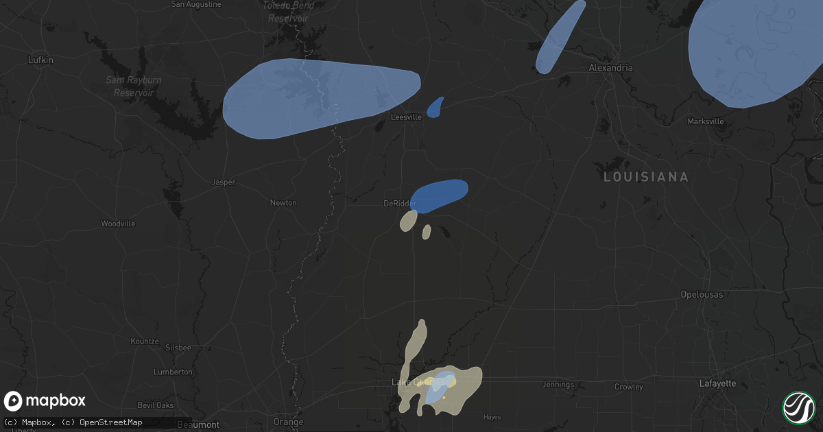
Hail Map in Deridder, LA on May 23, 2026
Get this storm
May 23 map
$229
one time, instant access
Download today. No call, no setup
Keep the $229
Bought the map and want the full workflow? Apply the entire $229 to a subscription within 7 days. None of it is wasted.
Every map, not just this one
This buys you this map. Subscription and you get every map we run, in the markets you choose from a few cities to whole states to nationwide. Plus real-time alerts the moment a storm fires.
Contact data
Name, contact info, occupancy, even credit band for addresses in the footprint. You go from where it hit to who to call.
Become the source they trust
Unlimited branding weather history reports on demand. You already have the documented answer ready for the property owner, and you are the one who showed up with it.
Property data and RoofTrace estimates
Pull up any address you have got, its value and the exact code rules for that jurisdiction, straight from One Click Code. Then RoofTrace estimates the squares, pitch, and roof value, priced the way you price.
Storm reports in Deridder, LA
Deridder, LA
| Date | Description |
|---|---|
| 05/23/20269:47 AM CDT | Two trees reported down on smyrna rd. Time estimated from radar. |
| 05/23/20269:43 AM CDT | Tree reported down covering both lanes on hwy 112 3 miles east of us 171 intersection. Time estimated by radar. |
| 05/23/20269:41 AM CDT | Tree reported down on dogwood trail covering 3/4 of the road. Time estimated from radar. |
| 05/23/20269:41 AM CDT | Law enforcement reports tree down on clarks landing rd covering entire road. Time estimated from radar. |
| 05/23/20269:15 AM CDT | Local law enforcement reports tree down on hwy 110 approx 3 miles west of hwy 27 junction. Time estimated from radar. |
All States Impacted by Hail Map on May 23, 2026
All Cities Impacted by Hail Map on May 23, 2026
- Beckville, TX
- Jefferson, TX
- Livingston, TX
- Cedar Key, FL
- Hondo, TX
- Karnack, TX
- Castroville, TX
- Devine, TX
- La Coste, TX
- Natalia, TX
- Abbeville, LA
- Fulton, AR
- Ogden, AR
- Westlake, LA
- Lake Charles, LA
- Brookeland, TX
- Pineland, TX
- Wiergate, TX
- Hemphill, TX
- Burkeville, TX
- Ragley, LA
- Iowa, LA
- Deridder, LA
- Bell City, LA
- Hornbeck, LA
- Anacoco, LA
- Florien, LA
- Leesville, LA
- Pitkin, LA
- Pleasanton, TX
- Christine, TX
- Jourdanton, TX
- Slagle, LA
- San Diego, TX
- Campbellton, TX
- Three Rivers, TX
- Gurdon, AR
- Falls City, TX
- Dry Prong, LA
- Lena, LA
- Bentley, LA
- Boyce, LA
- Colfax, LA
- Beeville, TX
- Kenedy, TX
- Robstown, TX
- Bishop, TX
- Taft, TX
- Portland, TX
- Corpus Christi, TX
- Tivoli, TX
- Victoria, TX
- Port Bolivar, TX
- Gregory, TX
- Port Aransas, TX
- Aransas Pass, TX
- Ingleside, TX
- Ferriday, LA
- Deville, LA
- Clayton, LA
- Sicily Island, LA
- Monterey, LA
- Acme, LA
- Woodville, MS
- Harrisonburg, LA
- Marksville, LA
- Vidalia, LA
- Natchez, MS
- Jena, LA
- Jonesville, LA
- Effie, LA
- Lorman, MS
- Waterproof, LA
- Saint Joseph, LA
- Rockport, TX
- Bayside, TX
- Goliad, TX
- Port Lavaca, TX
- Marbury, AL
- Fayette, MS
- Newellton, LA
- Fulton, TX
- Port O'Connor, TX
- Wrens, GA
- Verbena, AL
- Bloomington, TX
- Alpine, TX
- Blythe, GA
- Matthews, GA
- Wilmar, AR
- Rison, AR
- Augusta, GA
- Hephzibah, GA
- Galveston, TX
- Wagon Mound, NM
- Rich Hill, MO
- Walker, MO
- Millry, AL
- Harwood, MO
- Frankville, AL
- Lumber City, GA
- Glenwood, GA
- Reydon, OK
- Gilbertown, AL
- Silas, AL
- Stockton, MO
- El Dorado Springs, MO
- Canadian, TX
- Mount Vernon, GA
- Franklin, AL
- Pine Apple, AL
- Grenville, NM
- Saluda, SC
- Adrian, GA
- Louisville, AL
- Clio, AL
- Cheyenne, OK
- Sweetwater, OK
- Letohatchee, AL
- Fort Deposit, AL
- Batesburg, SC
- Trementina, NM
- Louisville, GA
- Bartow, GA
- Midkiff, TX
- Statesboro, GA
- Leesville, SC
- Prosperity, SC
- Midland, TX
- Walsh, CO
- Clayton, NM
- Arnett, OK
- Durham, OK
- Trinity, TX
- Cameron, TX
- Reidsville, GA
- Stanton, TX
- Milano, TX
- Indianola, NE
- McCook, NE
- McCamey, TX
- Odessa, TX
- Felt, OK
- Texline, TX
- Wesley Chapel, FL
- Collins, GA
- Claxton, GA
- Tampa, FL
- Garden City, TX
- Campo, CO
- Lutz, FL
- Pomona Park, FL
- Wallace, NE
- Blackshear, GA
- Alma, GA
- Dalhart, TX
- Nicholls, GA
- Big Spring, TX
- Dryden, TX
- Keyes, OK
- Knott, TX
- Groveland, FL
- Webster, FL
- Gail, TX
- Chappells, SC
- Ninety Six, SC
- Dallas, GA
- Hartley, TX
- Dumas, TX
- Mascotte, FL
- Fruitland Park, FL
- Lady Lake, FL
- Adrian, TX
- Channing, TX
- Marlin, TX
- Alachua, FL
- Gainesville, FL
- Brooker, FL
- Leesburg, FL
- Marathon, TX
- Sunray, TX
- Wray, GA
- Jacksonville, GA
- Ackerly, TX
- Lamesa, TX
- Goodwell, OK
- Muleshoe, TX
- Cactus, TX
- Masterson, TX
- Hereford, TX
- Amarillo, TX
- Sudan, TX
- Umatilla, FL
- Lake Butler, FL
- Big Lake, TX
- Broxton, GA
- Fitzgerald, GA
- Vega, TX
- Amherst, TX
- Brownfield, TX
- Howey In The Hills, FL
- Tokio, TX
- Stinnett, TX
- Texhoma, OK
- Welch, TX
- Enochs, TX
- Earth, TX
- Aspermont, TX
- Fritch, TX
- Panhandle, TX
- Tucumcari, NM
- Ozona, TX
- Littlefield, TX
- Levelland, TX
- Meadow, TX
- Friona, TX
- Tahoka, TX
- Colorado City, TX
- Satsuma, FL
- Anton, TX
- Shallowater, TX
- Loraine, TX
- Hermleigh, TX
- Odonnell, TX
- Wilson, TX
- Lubbock, TX
- Roscoe, TX
- Snyder, TX
- Elm Mott, TX
- Waco, TX
- Dimmitt, TX
- Idalou, TX
- Hart, TX
- Perryton, TX
- Sweetwater, TX
- Post, TX
- Lorenzo, TX
- Kress, TX
- Justiceburg, TX
- Tulia, TX
- Plainview, TX
- Lockney, TX
- Silverton, TX
- Afton, TX
- Matador, TX
- Flomot, TX
- Roaring Springs, TX
- Mcadoo, TX
- Dickens, TX
- Paducah, TX
- Cee Vee, TX
- Childress, TX
- Crowell, TX
- Quanah, TX
- Seymour, TX
- Old Glory, TX


