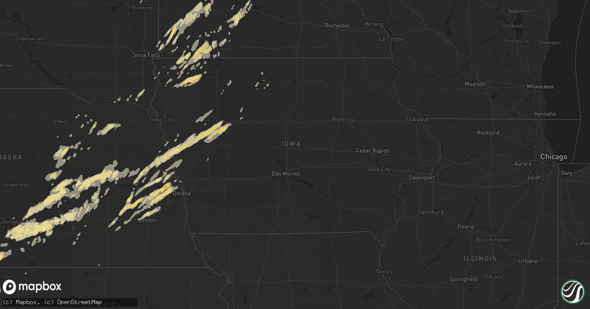
Hail Map in Iowa on May 23, 2012
Get this storm
May 23 map
$229
one time, instant access
Download today. No call, no setup
Keep the $229
Bought the map and want the full workflow? Apply the entire $229 to a subscription within 7 days. None of it is wasted.
Every map, not just this one
This buys you this map. Subscription and you get every map we run, in the markets you choose from a few cities to whole states to nationwide. Plus real-time alerts the moment a storm fires.
Contact data
Name, contact info, occupancy, even credit band for addresses in the footprint. You go from where it hit to who to call.
Become the source they trust
Unlimited branding weather history reports on demand. You already have the documented answer ready for the property owner, and you are the one who showed up with it.
Property data and RoofTrace estimates
Pull up any address you have got, its value and the exact code rules for that jurisdiction, straight from One Click Code. Then RoofTrace estimates the squares, pitch, and roof value, priced the way you price.
Storm reports in Iowa
Iowa
| Date | Description |
|---|---|
| 05/23/20126:45 PM CDT | A local report indicates 1.00 inch wind near 2 S ONAWA |
| 05/23/20126:34 PM CDT | A local report indicates 1.00 inch wind near BLENCOE |
| 05/22/20129:20 PM CDT | Hail lasted until 925 pm |
| 05/22/20128:40 PM CDT | Measured by weather station. 1/2 mile north of location boat dealership had damage. Delayed report. |
| 05/22/20128:32 PM CDT | Thirteen large power poles snapped along a mile long stretch of perkins ave. One third of the roof of a hog confinement building ripped off half a mile up the road. Ano |
| 05/22/20128:30 PM CDT | A local report indicates 1.00 inch wind near 5 E ODEBOLT |
| 05/22/20128:30 PM CDT | Damage from near east of odebolt to near early to the east side of lake view. Numerous power poles down...roofs blown off of outbuildings and turkey and hog confinement |
| 05/22/20127:40 PM CDT | Quarter hail with strong winds |
| 05/22/20127:20 PM CDT | Large branches down |
| 05/22/20127:10 PM CDT | A number of trees in a nearby grove either downed or lost large limbs. Likely gustnado also observed. Winds were estimated at 60 to 65 mph. Time estimated from radar. |
| 05/22/20127:00 PM CDT | Trees downed. |
All States Impacted by Hail Map on May 23, 2012
Cities Impacted by Hail Map on May 23, 2012
- Cameron, NC
- Carthage, NC
- Sanford, NC
- Greenville, NC
- Hudson, SD
- Fairview, SD
- Ordway, CO
- Rich Square, NC
- Vass, NC
- Monroe, NE
- Selden, KS
- Sheldon, IA
- Worthington, MN
- Sibley, IA
- Matlock, IA
- Lake Park, IA
- Ocheyedan, IA
- Boyden, IA
- George, IA
- Heron Lake, MN
- Okabena, MN
- Ashton, IA
- Lakefield, MN
- Bigelow, MN
- Round Lake, MN
- Brewster, MN
- Harris, IA
- North Bend, NE
- Dodge, NE
- Eads, CO
- Wiley, CO
- Lamar, CO
- Plainview, NE
- Creighton, NE
- Brunswick, NE
- Neligh, NE
- Sanborn, IA
- Hospers, IA
- Archer, IA
- Gates, NC
- Tarboro, NC
- Garland, NE
- Milford, NE
- Brainard, NE
- Raymond, NE
- Fremont, NE
- Omaha, NE
- Arlington, NE
- Ulysses, NE
- Staplehurst, NE
- Kennard, NE
- Ashland, NE
- Valparaiso, NE
- Ithaca, NE
- Seward, NE
- Malcolm, NE
- Elkhorn, NE
- David City, NE
- Yutan, NE
- Ceresco, NE
- Wahoo, NE
- Dwight, NE
- Weston, NE
- Waterloo, NE
- Bruno, NE
- Colon, NE
- Beaver Crossing, NE
- Mead, NE
- Valley, NE
- Bennington, NE
- Washington, NE
- Bee, NE
- Pleasant Dale, NE
- Utica, NE
- Davey, NE
- Mclean, NE
- Osmond, NE
- Lucan, MN
- Vesta, MN
- Pinehurst, NC
- Aberdeen, NC
- Southern Pines, NC
- Nelson, MN
- Ravenna, NE
- Loup City, NE
- Hazard, NE
- Ashton, NE
- Rockville, NE
- Magnolia, MN
- Holly, CO
- Ahoskie, NC
- Cofield, NC
- Youngsville, NC
- Benson, NC
- Clayton, NC
- Raleigh, NC
- Coats, NC
- Knightdale, NC
- Garner, NC
- Angier, NC
- Four Oaks, NC
- Franklinton, NC
- Wake Forest, NC
- Willow Spring, NC
- Gibbon, NE
- Wood River, NE
- Shelton, NE
- Herndon, KS
- Winnetoon, NE
- Aulander, NC
- Windsor, NC
- Lincoln, NE
- Bennettsville, SC
- Yoder, CO
- Rush, CO
- Suffolk, VA
- Colby, KS
- McDonald, KS
- Jackson, MN
- Tracy, MN
- Edison, NE
- Atwood, KS
- Eustis, NE
- Cambridge, NE
- Holbrook, NE
- North Loup, NE
- Farwell, NE
- Saint Paul, NE
- Elm Creek, NE
- Scotia, NE
- Wolbach, NE
- Boelus, NE
- Elba, NE
- Greeley, NE
- Pleasanton, NE
- Amherst, NE
- Miller, NE
- Williamston, NC
- Sac City, IA
- Odebolt, IA
- Wall Lake, IA
- Lake View, IA
- Kiron, IA
- West End, NC
- Fair Bluff, NC
- Evergreen, NC
- Galivants Ferry, SC
- Nichols, SC
- Orrum, NC
- Aynor, SC
- Cerro Gordo, NC
- Chadbourn, NC
- Green Sea, SC
- Loris, SC
- Lumberton, NC
- Tekamah, NE
- Decatur, NE
- Stokes, NC
- Ord, NE
- Fulda, MN
- Reading, MN
- Palmer, NE
- Axtell, NE
- Webb, IA
- Alda, NE
- Doniphan, NE
- Grand Island, NE
- Darlington, SC
- Hancock, MN
- Phillipsburg, KS
- Arapahoe, NE
- Cyrus, MN
- Alexandria, MN
- Lowry, MN
- Starbuck, MN
- Hartsville, SC
- Humphrey, NE
- Genoa, NE
- Columbus, NE
- Platte Center, NE
- Schuyler, NE
- Cedar Rapids, NE
- Saint Edward, NE
- Lindsay, NE
- Belgrade, NE
- Clarkson, NE
- Creston, NE
- Leigh, NE
- Fullerton, NE
- Elwood, NE
- Winterville, NC
- Pikeville, NC
- Goldsboro, NC
- La Grange, NC
- Snow Hill, NC
- Sleepy Eye, MN
- Ayden, NC
- Grimesland, NC
- Chocowinity, NC
- Washington, NC
- Scribner, NE
- Whitakers, NC
- Burbank, SD
- Vermillion, SD
- Hastings, NE
- Inland, NE
- Gayville, SD
- Sugar City, CO
- Pamplico, SC
- Effingham, SC
- Florence, SC
- Schleswig, IA
- Ute, IA
- Blencoe, IA
- West Point, NE
- Danbury, IA
- Hooper, NE
- Onawa, IA
- Battle Creek, IA
- Oakland, NE
- Charter Oak, IA
- Arthur, IA
- Craig, NE
- Ida Grove, IA
- Soldier, IA
- Castana, IA
- Early, IA
- Mapleton, IA
- Pipestone, MN
- Edgerton, MN
- Jasper, MN
- Gary, SD
- Marietta, MN
- Enfield, NC
- Grainfield, KS
- Grinnell, KS
- Society Hill, SC
- Cheraw, SC
- Blenheim, SC
- Randolph, NE
- Lake Wilson, MN
- Georgetown, SC
- Holly Springs, NC
- Pendleton, NC
- Margarettsville, NC
- Woodstock, MN
- Hardwick, MN
- Cedar Bluffs, NE
- Nickerson, NE
- Silver Creek, NE
- Raeford, NC
- Fayetteville, NC
- Fort Bragg, NC
- Hobgood, NC
- Denver, CO
- Garvin, MN
- Slayton, MN
- Inwood, IA
- Bartlett, NE
- Ericson, NE
- Ewing, NE
- Scranton, NC
- Balaton, MN
- Walnut Grove, MN
- Milroy, MN
- Gramercy, LA
- Paulina, LA
- Vanceboro, NC
- Grifton, NC
- Roseboro, NC
- Salemburg, NC
- Autryville, NC
- Godwin, NC
- Titonka, IA
- Burt, IA
- Darfur, MN
- New Ulm, MN
- Hanska, MN
- Saint James, MN
- Comfrey, MN
- Dresden, KS
- Midland, VA
- Jennings, KS
- Morland, KS
- Clayton, KS
- Rexford, KS
- Hoxie, KS
- Oberlin, KS
- Olivia, MN
- Funk, NE
- Newton Grove, NC
- Clinton, NC
- Blair, NE
- Scotland Neck, NC
- York, NE
- Hendley, NE
- Wilsonville, NE
- Lafayette, MN
- Fort Calhoun, NE
- Appleton, MN
- Rock Valley, IA
- Hull, IA
- Sioux Center, IA
- Kearney, NE
- Marion, SC
- Latta, SC
- Dillon, SC
- Sellers, SC
- Beresford, SD
- Chambers, NE
- Adrian, MN
- Waverly, NE
- McCool Junction, NE
- Exeter, NE
- Waco, NE
- Luverne, MN
- New Orleans, LA
- Wausa, NE
- Dunn, NC
- Lamberton, MN
- Morton, MN
- Redwood Falls, MN
- Defiance, IA
- Minden, NE
- Kittrell, NC
- Morris, MN
- Correll, MN
- Bellingham, MN
- Ortonville, MN
- Odessa, MN
- Windom, MN
- Alton, IA
- Hartley, IA
- Orange City, IA
- Primghar, IA
- Granville, IA
- Fordyce, NE
- Saint Helena, NE
- Sauk Centre, MN
- Lu Verne, IA
- Bird Island, MN
- Ellsworth, MN
- Rock Rapids, IA
- Little Rock, IA
- Rushmore, MN
- Woodland, NC
- Kelford, NC
- Roxobel, NC
- Olney Springs, CO
- Greenwell Springs, LA
- Eure, NC
- Fuquay Varina, NC
- Hector, MN
- Mountain Lake, MN
- Doon, IA
- Bogalusa, LA
- Monument, KS
- Lyons, NE
- Denison, IA
- Linwood, NE
- Breda, IA
- Deloit, IA
- Rogers, NE
- Vail, IA
- Lytton, IA
- Ricketts, IA
- Uehling, NE
- Beaver Creek, MN
- Ireton, IA
- Belview, MN
- Wabasso, MN
- Seaforth, MN
- Saint Pauls, NC
- Beaver City, NE
- Algona, IA
- Kenneth, MN
- Central City, NE
- Clarks, NE
- Glenvil, NE
- Ayr, NE
- Blue Hill, NE
- Whiting, IA
- Macy, NE
- Holdrege, NE
- Franklin, MN
- Holloway, MN
- Alberta, MN
- Farwell, MN
- Chokio, MN
- Pinebluff, NC
- Melvin, IA
- Cary, NC
- Ruthton, MN
- Currie, MN
- Chandler, MN
- Revere, MN
- Leota, MN
- Sorrento, LA
- Dannebrog, NE
- Cairo, NE
- Hoffman, NC
- Metairie, LA
- Prague, NE
- Morse Bluff, NE
- Ames, NE
- Giltner, NE
- Saint Inigoes, MD
- Dameron, MD
- Ridge, MD
- Lexington Park, MD
- Fairmont, NE
- Winton, NC
- Lewiston Woodville, NC
- Colerain, NC
- Orleans, NE
- Oxford, NE
- Moose Lake, MN
- Barnum, MN
- Hugo, CO
- Karval, CO
- Bode, IA
- Timmonsville, SC
- Garretson, SD
- Bruce, SD
- Toronto, SD
- Brookings, SD
- Brandt, SD
- Hornick, IA
- Rocky Mount, NC
- Halifax, NC
- Madison, MN
- Wilcox, NE
- Oak City, NC
- Hamilton, NC
- Henderson, NC
- Pensacola, FL
- Overton, NE
- Lexington, NE
- Loomis, NE
- Bertrand, NE
- Smithfield, NE
- Elgin, NE
- Farmville, NC
- Friend, NE
- Granite Falls, MN
- Syracuse, KS
- Howells, NE
- Alvord, IA
- Clearwater, NE
- Danube, MN
- Fairmont, NC
- Litchfield, NE
- Ludell, KS
- Greenwood, NE
- Westfield, IA
- Smithland, IA
- Conway, NC
- Iona, MN
- Wilmont, MN
- Franklinton, LA
- Odessa, NE
- Aurora, NE
- Polk, NE
- Marquette, NE
- Riverdale, NE
- Hordville, NE
- Phillips, NE
- Chapman, NE
- Bethel, NC
- Hookerton, NC
- Kinston, NC
- Glenwood, MN
- Oakdale, NE
- Levant, KS
- Lenora, KS
- Norton, KS
- Norcatur, KS
- Smithfield, NC
- Royal, NE
- Orchard, NE
- Bingham Lake, MN
- Ruthven, IA
- Ayrshire, IA
- Clear Lake, SD
- Alpha, MN
- Montevideo, MN
- Malmo, NE
- Herman, NE
- Little Sioux, IA
- Pisgah, IA
- Mondamin, IA
- Butterfield, MN
- Manson, IA
- Verdigre, NE
- Kanaranzi, MN
- Burwell, NE
- Holstein, IA
- Alta, IA
- Galva, IA
- Schaller, IA
- Cushing, IA
- Storm Lake, IA
- Courtland, MN
- Palmer, IA
- Saint Bernard, LA
- Lillington, NC
- Oakley, KS
- Crofton, NE
- Jackson, NC
- Wesley, IA
- Corwith, IA
- Revillo, SD
- Byron, NE
- Osceola, NE
- Madison, NE
- Heartwell, NE
- Hampton, NE
- Durham, NC
- Boone, CO


