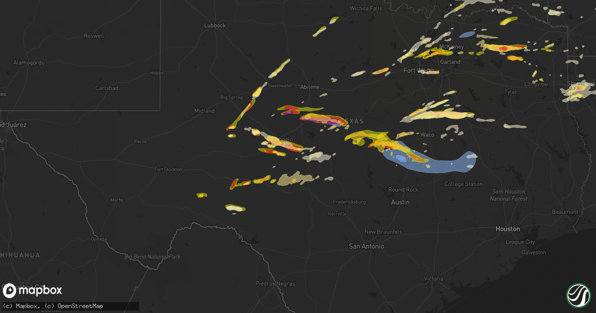
Hail Map in Texas on May 22, 2024
Get this storm
May 22 map
$229
one time, instant access
Download today. No call, no setup
Keep the $229
Bought the map and want the full workflow? Apply the entire $229 to a subscription within 7 days. None of it is wasted.
Every map, not just this one
This buys you this map. Subscription and you get every map we run, in the markets you choose from a few cities to whole states to nationwide. Plus real-time alerts the moment a storm fires.
Contact data
Name, contact info, occupancy, even credit band for addresses in the footprint. You go from where it hit to who to call.
Become the source they trust
Unlimited branding weather history reports on demand. You already have the documented answer ready for the property owner, and you are the one who showed up with it.
Property data and RoofTrace estimates
Pull up any address you have got, its value and the exact code rules for that jurisdiction, straight from One Click Code. Then RoofTrace estimates the squares, pitch, and roof value, priced the way you price.
Storm reports in Texas
Texas
| Date | Description |
|---|---|
| 05/22/20246:55 PM CDT | Report from mping: quarter |
| 05/22/20246:53 PM CDT | Report from mping: ping pong ball |
| 05/22/20246:40 PM CDT | Reported by public via kltv facebook near intersection of hynson springs road and fm road 450. |
| 05/22/20246:37 PM CDT | Report from mping: ping pong ball |
| 05/22/20246:35 PM CDT | Destroyed mobile home... Along with part of a roof off a home off highway 53 between zabcikville and seaton. Time estimated. |
| 05/22/20246:35 PM CDT | Corrects previous hail report from 9 nne rogers. Destroyed mobile home... Along with part of a roof off a home off highway 53 between zabcikville and seaton. Time estim |
| 05/22/20246:35 PM CDT | Damage to planes at ktpl airport in temple. One plane flipped over... Another one blown into a ditch... Other debris scattered about. |
| 05/22/20246:33 PM CDT | Ef-1 damage was found on the southeast side of temple off of fm 3117. Maximum estimated winds are 95 mph. |
| 05/22/20246:30 PM CDT | Reported in diana community. |
| 05/22/20246:30 PM CDT | Correction...hail quarter to ping pong size reported in diana community from public photos and amateur radio. |
| 05/22/20246:29 PM CDT | Social media video and images of damage to temple mall... Including large windows blown out and damage to walls. Time estimated via radar. |
| 05/22/20246:25 PM CDT | Roof damage to homes and power poles snapped. Time estimated. |
| 05/22/20246:25 PM CDT | Report from mping: quarter |
| 05/22/20246:24 PM CDT | Video relayed by broadcast media of a tornado moving through the parks of westfield area of temple. Time estimated via radar. |
| 05/22/20246:23 PM CDT | Report from mping: ping pong ball |
| 05/22/20246:21 PM CDT | *** 30 inj *** ef-2 damage was found in west temple with maximum estimated winds of 120 mph. |
| 05/22/20246:20 PM CDT | Social media photos. Damage to several commercial buildings near w adams and hilliard rd. Time estimated. |
| 05/22/20246:20 PM CDT | Damaged metal barn in bruceville-eddy. Time estimated. |
| 05/22/20246:11 PM CDT | 76 mph measured at khlr. |
| 05/22/20246:03 PM CDT | Most stones between 1 and 1.25 with max 1.75. |
| 05/22/20246:00 PM CDT | Trees down on fm road 1448. |
| 05/22/20245:47 PM CDT | Photo of hail in leesburg community via kltv facebook page. |
| 05/22/20245:40 PM CDT | A local report indicates 1.00 inch wind near 1 ESE Mertzon |
| 05/22/20245:35 PM CDT | A local report indicates 1.25 inch wind near 3 NE Knickerbocker |
| 05/22/20245:32 PM CDT | Public photo via kltv facebook of hail on county road 4420 near the winnsboro and scroggins area. |
| 05/22/20245:32 PM CDT | Trained spotter reports quarter size hail 1 mile ne of downtown winnsboro on fm 1448. |
| 05/22/20245:32 PM CDT | A local report indicates 1.75 inch wind near 4 NW Vancourt |
| 05/22/20245:30 PM CDT | A local report indicates 1.00 inch wind near 2 W Wall |
| 05/22/20245:28 PM CDT | A local report indicates 1.25 inch wind near 6 NW Capitola |
| 05/22/20245:26 PM CDT | A local report indicates 1.00 inch wind near Mertzon |
| 05/22/20245:25 PM CDT | Numerous trees down in and around the winnsboro area. |
| 05/22/20245:20 PM CDT | A local report indicates 2.50 inch wind near Wingate |
| 05/22/20245:02 PM CDT | A local report indicates 1.50 inch wind near 3 W San Angelo |
| 05/22/20244:58 PM CDT | A local report indicates 1.75 inch wind near 3 WSW San Angelo |
| 05/22/20244:55 PM CDT | Report from mping: half dollar |
| 05/22/20244:54 PM CDT | A local report indicates 2.00 inch wind near 4 WSW San Angelo |
| 05/22/20244:53 PM CDT | A local report indicates 1.00 inch wind near 4 W San Angelo |
| 05/22/20244:32 PM CDT | A local report indicates 1.00 inch wind near Colorado City |
| 05/22/20244:26 PM CDT | Reported in lake colorado city. |
| 05/22/20244:25 PM CDT | Report from mping: ping pong ball |
| 05/22/20244:20 PM CDT | Golf ball size hail south of mineral wells. |
| 05/22/20244:20 PM CDT | 1 in hail. |
| 05/22/20244:20 PM CDT | Report from mping: ping pong ball |
| 05/22/20244:13 PM CDT | Report from mping: quarter |
| 05/22/20244:13 PM CDT | Report from mping: quarter |
| 05/22/20244:13 PM CDT | A local report indicates 1.00 inch wind near 13 SW Colorado City |
| 05/22/20244:10 PM CDT | Storm chaser video showing tornado on the ground. Location estimated by radar. |
| 05/22/20244:02 PM CDT | Report from mping: quarter |
| 05/22/20244:02 PM CDT | Report from mping: quarter |
| 05/22/20243:50 PM CDT | A local report indicates 1.00 inch wind near 3 S Lake Brownwood |
| 05/22/20243:43 PM CDT | Storm spotter measured a wind gust of 66.7 mph. |
| 05/22/20243:36 PM CDT | Law enforcement confirmed tornado on the ground about the cross highway 163 s. |
| 05/22/20243:18 PM CDT | A local report indicates 1.75 inch wind near Coleman |
| 05/22/20243:11 PM CDT | 1.25 in hail coit and legacy. |
| 05/22/20243:10 PM CDT | Coleman fire chief reported multiple utility poles down. Time and location estimated by radar. |
| 05/22/20243:10 PM CDT | A local report indicates 1.50 inch wind near Coleman |
| 05/22/20243:00 PM CDT | A local report indicates 1.00 inch wind near 1 NNE Glen Cove |
| 05/22/20242:59 PM CDT | Report from mping: quarter |
| 05/22/20242:49 PM CDT | 1 in hail corner of preston and legacy. |
| 05/22/20242:48 PM CDT | Report from mping: quarter |
| 05/22/20242:46 PM CDT | Power lines down over the highway. Winds estimated to be 70 mph. |
| 05/22/20242:45 PM CDT | Report from mping: quarter |
| 05/22/20242:40 PM CDT | Report from mping: quarter |
| 05/22/20242:39 PM CDT | 1 in hail srt and preston. |
| 05/22/20242:38 PM CDT | 1 in hail in the colony. |
| 05/22/20242:30 PM CDT | Photo on twitter. |
| 05/22/20242:23 PM CDT | 68 mph wind gust. |
| 05/22/20242:20 PM CDT | Report from mping: quarter |
| 05/22/20242:14 PM CDT | Report from mping: ping pong ball |
| 05/22/20242:09 PM CDT | Report from mping: quarter |
| 05/22/20242:08 PM CDT | 1 in hail in flower mound. |
| 05/22/20242:05 PM CDT | Report from mping: quarter |
| 05/22/20241:55 PM CDT | 1 in hail in frisco lakes. |
| 05/22/20241:43 PM CDT | Report from mping: half dollar |
| 05/22/20241:43 PM CDT | A local report indicates 1.00 inch wind near Wingate |
| 05/22/20241:28 PM CDT | Report from mping: quarter |
| 05/22/20241:28 PM CDT | Report from mping: quarter |
| 05/22/20241:26 PM CDT | Report from mping: quarter |
| 05/22/20241:20 PM CDT | A local report indicates 2.75 inch wind near 10 N Bronte |
| 05/22/20241:14 PM CDT | Report from mping: quarter |
| 05/22/20241:13 PM CDT | Time estimated by radar. |
| 05/22/20241:09 PM CDT | 1 in hail in flower mound. |
| 05/22/20241:05 PM CDT | 1 in hail in van alstyne. |
| 05/22/20241:01 PM CDT | Report from mping: quarter |
| 05/22/202412:36 PM CDT | Report from mping: quarter |
| 05/22/202412:27 PM CDT | Quarter size hail s of cottondate. |
| 05/22/202412:39 AM CDT | Corrects previous hail report from 1 e ennis. Report from mping: quarter |
| 05/21/202410:11 PM CDT | Report from mping: half dollar |
| 05/21/202410:10 PM CDT | Half dollar sized hail reported near fm 1713 at fm 933 north of whitney. |
| 05/21/20249:40 PM CDT | Trees and power lines reported down in several areas of the county... Including the city of nacogdoches. In western portion of the county on hwy 225 near douglass... Co |
| 05/21/20249:30 PM CDT | Large tree uprooted at intersection of austin and raguet streets. The tree damaged the adjacent traffic lights. |
| 05/21/20249:30 PM CDT | Tree down on power lines on county road 2041. |
| 05/21/20249:30 PM CDT | Tree down on stoddard drive. |
| 05/21/20249:25 PM CDT | Rusk county deputy reports tree down at us highway 84 and fm road 225 intersection. |
| 05/21/20249:00 PM CDT | County dispatch reports of several trees down near grapeland due to strong winds from thunderstorms. |
| 05/21/20249:00 PM CDT | County dispatch reports of severa |
| 05/21/20248:45 PM CDT | Numerous trees and powerlines down along hwy 294 from elkhart to slocum. Reports of trees fallen on homes and vehicles. Time estimated from radar. |
| 05/21/20248:42 PM CDT | Photo of hail near quarter size via kltv facebook. |
| 05/21/20248:35 PM CDT | Tree fell onto a house near highway 294 and fm 2419. Time estimated. |
| 05/21/20248:33 PM CDT | Trees and power lines down near intersection lf fm road 115 and fm road 900. |
| 05/21/20248:31 PM CDT | County dispatch reports of trees down due to thunderstorms near the town of midway. |
| 05/21/20248:10 PM CDT | A local report indicates 1.00 inch wind near Blossom |
| 05/21/20248:05 PM CDT | Corrects previous hail report from 6 n como. |
| 05/21/20248:05 PM CDT | A local report indicates 2.50 inch wind near 6 N Como |
| 05/21/20248:04 PM CDT | Report from mping. |
| 05/21/20247:56 PM CDT | County dispatch reports of trees down due to thunderstorms near north zulch. |
| 05/21/20247:54 PM CDT | Report from mping. |
| 05/21/20247:53 PM CDT | Report from mping. |
| 05/21/20247:50 PM CDT | A local report indicates 1.75 inch wind near 4 NNW Sulphur Springs |
| 05/21/20247:50 PM CDT | County dispatch reports of trees down near pine tree rd and old bundick rd due to thunderstorm winds. Additional tree down on deep well rd. |
| 05/21/20247:47 PM CDT | A local report indicates 1.00 inch wind near 5 NW Sulphur Springs |
| 05/21/20247:25 PM CDT | Tree fell onto a house in kosse. Time estimated. |
| 05/21/20247:15 PM CDT | Tree down... Downed power lines... Roof off house. Time estimated. |
| 05/21/20247:08 PM CDT | Report from mping: quarter |
| 05/21/20247:05 PM CDT | Photo of dime to quarter size hail in the spring hill area of longview via kltv facebook page. |
| 05/21/20247:04 PM CDT | 60 mph reported in cameron. |
| 05/21/20247:04 PM CDT | Report from mping: quarter |
All States Impacted by Hail Map on May 22, 2024
Cities Impacted by Hail Map on May 22, 2024
- Hinton, OK
- Calumet, OK
- El Reno, OK
- Yukon, OK
- Oklahoma City, OK
- Jones, OK
- Spencer, OK
- Bethany, OK
- Tulsa, OK
- Choctaw, OK
- Harrah, OK
- Nowata, OK
- Cache, OK
- Mcloud, OK
- Meeker, OK
- Lawton, OK
- Broken Arrow, OK
- Wellston, OK
- Prague, OK
- Fort Sill, OK
- Shawnee, OK
- Fletcher, OK
- Vinita, OK
- Chelsea, OK
- Elgin, OK
- Earlsboro, OK
- Seminole, OK
- Paden, OK
- Okemah, OK
- Wewoka, OK
- Cement, OK
- Cyril, OK
- Boley, OK
- Inola, OK
- Grove, OK
- Weleetka, OK
- Anderson, MO
- Tahlequah, OK
- Noel, MO
- Lanagan, MO
- Wetumka, OK
- South West City, MO
- Bartlesville, OK
- Dewey, OK
- Stilwell, OK
- Lincoln, AR
- Wann, OK
- Berryville, AR
- Elmore City, OK
- Copan, OK
- Eufaula, OK
- Coffeyville, KS
- S Coffeyville, OK
- Canehill, AR
- Westville, OK
- Morrow, AR
- Prairie Grove, AR
- Wynnewood, OK
- Pauls Valley, OK
- Huntsville, AR
- Green Forest, AR
- Alpena, AR
- Stigler, OK
- Quinton, OK
- Canadian, OK
- Stratford, OK
- Davis, OK
- Sulphur, OK
- Roff, OK
- West Fork, AR
- Evansville, AR
- Winslow, AR
- Edna, KS
- Blue Eye, MO
- Hollister, MO
- Scottsville, KY
- Mill Creek, OK
- Ada, OK
- Fitzhugh, OK
- Branson, MO
- Kinta, OK
- Whitefield, OK
- Oswego, KS
- Park Hill, OK
- Stonewall, OK
- Tishomingo, OK
- Tupelo, OK
- Mccurtain, OK
- Red Oak, OK
- Kingston, AR
- Fittstown, OK
- Coalgate, OK
- Centrahoma, OK
- Wapanucka, OK
- Atoka, OK
- Milburn, OK
- Wilburton, OK
- Compton, AR
- Ponca, AR
- Williamsfield, OH
- Glasgow, KY
- Lucas, KY
- Coleman, OK
- Kiowa, OK
- Stringtown, OK
- Pittsburg, OK
- Wardville, OK
- Jamestown, PA
- Hartstown, PA
- Lane, OK
- Daisy, OK
- Clayton, OK
- Antlers, OK
- Knob Lick, KY
- Valley Springs, AR
- Yellville, AR
- Hartville, MO
- Grovespring, MO
- Talihina, OK
- Honobia, OK
- Nashoba, OK
- Mineral Wells, TX
- Falcon, MO
- Lynchburg, MO
- Mountain Grove, MO
- Portland, TN
- Memphis, TN
- Decatur, TX
- Rhome, TX
- Snow, OK
- Augusta, AR
- Millington, TN
- Westmoreland, TN
- Lavinia, TN
- Arlington, TN
- Cedar Grove, TN
- West Memphis, AR
- Plato, MO
- Bethpage, TN
- Ponder, TX
- Weatherford, TX
- Sanger, TX
- McCrory, AR
- Tennessee Ridge, TN
- Atoka, TN
- Poolville, TX
- Ridgely, TN
- Stewart, TN
- Bruceton, TN
- Huntingdon, TN
- Krum, TX
- Erin, TN
- Stanton, TN
- Paradise, TX
- Mason, TN
- Brighton, TN
- Muse, OK
- Whitesboro, OK
- Boyd, TX
- Springtown, TX
- Silver Creek, NY
- South Shore, KY
- South Portsmouth, KY
- Collinsville, TX
- Whitesboro, TX
- Hodgen, OK
- Hollidaysburg, PA
- Irving, NY
- Hornbeak, TN
- Greenup, KY
- Franklin Furnace, OH
- Denton, TX
- Hickory Ridge, AR
- Wynne, AR
- Cherry Valley, AR
- Newark, TX
- Valley View, TX
- Swifton, AR
- Stuart, OK
- Azle, TX
- Haslet, TX
- Clarendon, AR
- Brinkley, AR
- Troy, TN
- Obion, TN
- Angola, NY
- Aubrey, TX
- Jonesboro, AR
- Bono, AR
- Cash, AR
- Ironton, OH
- Worthington, KY
- Cumberland City, TN
- Justin, TX
- Denison, TX
- De Valls Bluff, AR
- Russell, KY
- Ulm, AR
- Stuttgart, AR
- Sherman, TX
- Hendrix, OK
- Drummonds, TN
- Munford, TN
- Smithville, OK
- Fort Worth, TX
- Bay, AR
- State University, AR
- Roanoke, TX
- Brookland, AR
- Argyle, TX
- Huntingdon, PA
- Alexandria, PA
- Parkin, AR
- Kitts Hill, OH
- Flatwoods, KY
- Earle, AR
- Keller, TX
- Red Boiling Springs, TN
- Lafayette, TN
- Gamaliel, KY
- Tompkinsville, KY
- Gunter, TX
- Celina, TX
- Hamburg, NY
- Eden, NY
- Pedro, OH
- Ashland, KY
- Derby, NY
- Lake View, NY
- Pilot Point, TX
- Mcalester, OK
- Harrisburg, AR
- Fisher, AR
- Big Sandy, TN
- Williamsburg, PA
- Pottsboro, TX
- Colbert, OK
- Weiner, AR
- Rives, TN
- Union City, TN
- Robert Lee, TX
- Bronte, TX
- Scottown, OH
- Proctorville, OH
- Chesapeake, OH
- Willow Wood, OH
- South Point, OH
- Savanna, OK
- Flower Mound, TX
- Lewisville, TX
- Clyde, TX
- Dresden, TN
- Martin, TN
- Calera, OK
- Hestand, KY
- Van Alstyne, TX
- Crawfordsville, AR
- Cartwright, OK
- Marion, AR
- Clarksville, TN
- Waverly, TN
- Moro, AR
- Petersburg, PA
- Brownsville, TN
- Burkesville, KY
- Tyronza, AR
- Wingate, TX
- Turrell, AR
- Gilmore, AR
- Lake City, AR
- Durant, OK
- Caraway, AR
- Marked Tree, AR
- Leachville, AR
- Monette, AR
- Black Oak, AR
- Lesage, WV
- Huntington, WV
- Ona, WV
- Parker, PA
- McEwen, TN
- Trumann, AR
- Lock Haven, PA
- Cammal, PA
- Tioga, TX
- Crown City, OH
- Baird, TX
- Whitewright, TX
- Widener, AR
- Forrest City, AR
- Moss, TN
- Winters, TX
- Marianna, AR
- Milton, WV
- Rattan, OK
- Heth, AR
- Lake Dallas, TX
- Bells, TN
- Walnut Ridge, AR
- Holly Grove, AR
- Barboursville, WV
- Norton, TX
- Dover, TN
- Paris, TN
- Mansfield, TN
- Springville, TN
- Glenwood, WV
- Anna, TX
- Buena Vista, TN
- Camden, TN
- Ivanhoe, TX
- Telephone, TX
- Caddo, OK
- Caney, OK
- Mckinney, TX
- Bokchito, OK
- Little Elm, TX
- Frisco, TX
- The Colony, TX
- Osceola, AR
- Blytheville, AR
- Manila, AR
- Etowah, AR
- Dell, AR
- Luxora, AR
- Wilson, AR
- Keiser, AR
- Lepanto, AR
- Hurricane, WV
- Culloden, WV
- Dryden, TX
- Hillsville, VA
- Hiwassee, VA
- Dugspur, VA
- Cumberland Furnace, TN
- Cunningham, TN
- Palmyra, TN
- Albany, KY
- Ballinger, TX
- Southlake, TX
- Martinsburg, PA
- James Creek, PA
- Aubrey, AR
- Grapevine, TX
- Sumner, TX
- Vanleer, TN
- Prosper, TX
- Beech Grove, AR
- Medina, TN
- Proctor, AR
- Mill Hall, PA
- Hope, AR
- Indian Mound, TN
- Mingus, TX
- Cross Plains, TX
- Ranger, TX
- Eastland, TX
- Santo, TX
- Cisco, TX
- Gordon, TX
- Millsap, TX
- Carlsbad, TX
- Burkett, TX
- Rowena, TX
- Aledo, TX
- Miles, TX
- Lipan, TX
- Gorman, TX
- Talpa, TX
- Sheffield, TX
- Goodfellow Afb, TX
- Carbon, TX
- Coleman, TX
- Rising Star, TX
- San Angelo, TX
- Mertzon, TX
- Indian Valley, VA
- Covington, TN
- Henning, TN
- Ripley, TN
- Hemlock, NY
- Livonia, NY
- Honeoye, NY
- Bethel, OK
- Loganton, PA
- Moran, TX
- Summerville, PA
- Springwater, NY
- Oakfield, TN
- Leonard, TX
- Blue Ridge, TX
- Trenton, TX
- Hesston, PA
- Marvell, AR
- Southside, TN
- Eva, TN
- Plano, TX
- Carrollton, TX
- Halls, TN
- Gates, TN
- Friendship, TN
- Dyersburg, TN
- Broken Bow, OK
- Humboldt, TN
- Lexa, AR
- Poplar Grove, AR
- Charlotte, TN
- Celeste, TX
- Cadiz, KY
- Jersey Shore, PA
- Honey Grove, TX
- Novice, TX
- Wayland, NY
- Canandaigua, NY
- Naples, NY
- Denmark, TN
- Jackson, TN
- Moyers, OK
- Newbern, TN
- Cordova, TN
- Ashland City, TN
- Wolfe City, TX
- Saint Albans, WV
- Garden City, TX
- Ridgway, PA
- Prescott, AR
- Colt, AR
- Palestine, AR
- Cerulean, KY
- Valliant, OK
- Oakland, TN
- Somerville, TN
- Eads, TN
- Brockway, PA
- Blevins, AR
- Big Lake, TX
- Valera, TX
- Watson, OK
- Allen, TX
- Brockport, PA
- Whiteville, TN
- Helena, AR
- North Bend, PA
- Gadsden, TN
- West Helena, AR
- Dickson, TN
- New Boston, TX
- Tuskahoma, OK
- Dallas, TX
- Tunica, MS
- Dundee, MS
- Bailey, TX
- Bonham, TX
- Wister, OK
- Santa Anna, TX
- Wylie, TX
- Kersey, PA
- Winchester, VA
- Gore, VA
- Breckenridge, TX
- Caddo, TX
- Ringold, OK
- Paris, TX
- New Castle, VA
- Waiteville, WV
- Gurdon, AR
- Spring Valley, MN
- Sterling City, TX
- Sedalia, KY
- Gap Mills, WV
- Mayfield, KY
- Greenfield, TN
- Rutherford, TN
- Brownwood, TX
- Princeton, TX
- Nevada, TX
- Coahoma, MS
- Trenton, TN
- Ashdown, AR
- Beaver Dams, NY
- Gilbertsville, KY
- Bangs, TX
- Wykoff, MN
- Fountain, MN
- White Lake, NY
- Swan Lake, NY
- Monticello, NY
- Smallwood, NY
- Benton, KY
- Rochelle, TX
- King Ferry, NY
- Oswego, NY
- Strawn, TX
- Brookesmith, TX
- Goodlettsville, TN
- Detroit, TX
- Kirksey, KY
- Joelton, TN
- Whites Creek, TN
- Lavon, TX
- Farmersville, TX
- Wildersville, TN
- Yuma, TN
- May, TX
- Blanket, TX
- Early, TX
- Palo Pinto, TX
- Nashville, TN
- Mullin, TX
- Monticello, KY
- Caddo Mills, TX
- Westbrook, TX
- Preston, MN
- Salem, VA
- Elliston, VA
- Gouldbusk, TX
- Alpha, KY
- Greenville, TX
- Genoa, NY
- Kuttawa, KY
- Sledge, MS
- Hardin, KY
- Madison, TN
- Weedville, PA
- Sardis, MS
- Batesville, MS
- Hendersonville, TN
- Greenbrier, TN
- Goldthwaite, TX
- Richland Springs, TX
- Rossville, TN
- White House, TN
- Cottontown, TN
- Bradford, TN
- Princeton, KY
- Williston, TN
- Catawba, VA
- Point, TX
- Lanesboro, MN
- Harmony, MN
- Clear Brook, VA
- Stephenson, VA
- Bethel, NY
- Hickory, KY
- Galeton, PA
- Collierville, TN
- Royse City, TX
- Comstock, TX
- Colorado City, TX
- Russell Springs, KY
- Calvert City, KY
- Emory, TX
- Evant, TX
- Westfield, PA
- Charleston, AR
- Dawson Springs, KY
- Providence, KY
- Nebo, KY
- Ratcliff, AR
- Branch, AR
- Zephyr, TX
- Fincastle, VA
- Garland, TX
- Sunnyvale, TX
- Rockwall, TX
- Lampasas, TX
- Quinlan, TX
- Mongaup Valley, NY
- Nancy, KY
- Jamestown, KY
- Boaz, KY
- Priddy, TX
- Washington, AR
- Hamilton, TX
- Campbell, TX
- Lone Oak, TX
- Brashear, TX
- Sulphur Springs, TX
- Bolivar, TN
- Buchanan, VA
- Summer Shade, KY
- Blackwell, TX
- Beaumont, KY
- Edmonton, KY
- Ozark, AR
- Paris, AR
- Star, TX
- Lometa, TX
- Marietta, TX
- Fulton, NY
- San Saba, TX
- Naples, TX
- Pottsville, TX
- Old Hickory, TN
- Whitetop, VA
- Lansing, NC
- Loraine, TX
- Douglassville, TX
- Gatesville, TX
- Purmela, TX
- Sebree, KY
- Lewistown, PA
- Slaughters, KY
- Manitou, KY
- Almo, KY
- Sweetwater, TX
- Hermleigh, TX
- Canton, MN
- Jonesboro, TX
- Mouth Of Wilson, VA
- Copperas Cove, TX
- Roby, TX
- Eola, TX
- Wall, TX
- Scroggins, TX
- Winnsboro, TX
- Calhoun, KY
- Muscoda, WI
- Richland Center, WI
- Pickton, TX
- Mifflin, PA
- Fredonia, KY
- Valley Mills, TX
- Ovalo, TX
- Rotan, TX
- Mifflintown, PA
- Port Royal, PA
- Como, TX
- Celina, TN
- Vancourt, TX
- Paint Rock, TX
- Christoval, TX
- Hamlin, TX
- Leesburg, TX
- Lone Rock, WI
- Mexico, NY
- Minetto, NY
- McVeytown, PA
- Owensboro, KY
- Utica, KY
- Crawford, TX
- Oglesby, TX
- Ferryville, WI
- Kempner, TX
- Eden, TX
- Fort Hood, TX
- Soldiers Grove, WI
- Rockport, IN
- Wellsboro, PA
- Queen City, TX
- Sabinsville, PA
- Gotham, WI
- Goldsboro, TX
- McCaulley, TX
- Scottsburg, IN
- Cross Fork, PA
- English, IN
- Longview, TX
- White Oak, TX
- Lewisport, KY
- Maceo, KY
- McGregor, TX
- Woodway, TX
- Knifley, KY
- Atlanta, TX
- Hilham, TN
- Harker Heights, TX
- Killeen, TX
- Thompsontown, PA
- Temple, TX
- Nolanville, TX
- Moody, TX
- Belton, TX
- Salado, TX
- Honey Grove, PA
- Eaton, OH
- Monroe, TN
- Byrdstown, TN
- Grannis, AR
- Pall Mall, TN
- Foreman, AR
- Texarkana, TX
- Bloomburg, TX
- De Queen, AR
- Pittsburg, TX
- Barnhart, TX
- China Spring, TX
- Waco, TX
- Madisonville, KY
- West Milton, OH
- Laura, OH
- Ludlow Falls, OH
- Troy, OH
- Austin, IN
- Lewisburg, OH
- Verona, OH
- Hewitt, TX
- Elm Mott, TX
- Brookville, OH
- Arcanum, OH
- Doddridge, AR
- Gilmer, TX
- Huntsville, OH
- Brookville, IN
- Gallatin, TN
- Mount Juliet, TN
- West Alexandria, OH
- Ozona, TX
- Hallsville, TX
- Deputy, IN
- Bethany, LA
- Shreveport, LA
- Keithville, LA
- Sidney, OH
- Belle Center, OH
- Cookville, TX
- Diana, TX
- Axtell, TX
- Arlington, TX
- Troy, TX
- Kenton, OH
- Vivian, LA
- Prairie Hill, TX
- Philpot, KY
- Bellefontaine, OH
- Rushsylvania, OH
- Grand Prairie, TX
- Conover, OH
- Saint Paris, OH
- Fletcher, OH
- Casstown, OH
- Lorena, TX
- Bruceville, TX
- Richland, NY
- Quincy, OH
- De Graff, OH
- Rosewood, OH
- Mount Victory, OH
- Little River Academy, TX
- Rogers, TX
- Riesel, TX
- Ida, LA
- Mart, TX
- Mount Calm, TX
- Fouke, AR
- La Rue, OH
- Harpster, OH
- Bossier City, LA
- Commerce, TX
- Ridgeway, OH
- West Mansfield, OH
- Coolidge, TX
- Nevada, OH
- Upper Sandusky, OH
- Morral, OH
- Tillar, AR
- Groesbeck, TX
- Mexia, TX
- Burlington, TX
- Marshall, TX
- Georgetown, IN
- Monticello, AR
- Rosebud, TX
- Lott, TX
- Buckholts, TX
- Urbana, OH
- Chidester, AR
- Bucyrus, OH
- Munday, TX
- Weinert, TX
- Goree, TX
- Cameron, TX
- Holland, TX
- Bremond, TX
- Calvert, TX
- Hearne, TX
- Franklin, TX
- Cumby, TX
- Gainesville, TX
- Thornton, TX
- Teague, TX
- Howe, TX
- Reagan, TX
- Klondike, TX
- Aspermont, TX
- Clarksdale, MS
- Ladonia, TX
- Pecan Gap, TX
- Cooper, TX
- Albany, TX
- Coppell, TX
- Bryan, TX
- Gause, TX
- Marquez, TX
- Marion, OH
- Seymour, TX
- Redfield, NY
- Richwood, OH
- Lowville, NY
- Livingston, TN
- Allons, TN
- Haughton, LA
- Wortham, TX
- De Berry, TX
- New Bloomington, OH
- Green Camp, OH
- Prospect, OH
- Blue Grass, VA
- Ben Franklin, TX
- Pleasant Shade, TN
- Brookston, TX
- Collins, OH
- Xenia, OH
- Wakeman, OH
- Oberlin, OH
- Amherst, OH
- Elyria, OH
- Avon, OH
- Avon Lake, OH
- Pulaski, TN
- Circleville, WV
- Blossom, TX
- New London, OH
- Cookeville, TN
- Keatchie, LA
- Monroe, LA
- Farmerville, LA
- Sterlington, LA
- Rickman, TN
- Yantis, TX
- Greenwood, LA
- Willard, OH
- Greenwich, OH
- Roxton, TX
- Saltillo, TX
- Dubach, LA
- Junction City, AR
- El Dorado, AR
- Bivins, TX
- Karnack, TX
- Waskom, TX
- Normangee, TX
- Old Glory, TX
- Pattonville, TX
- North Fairfield, OH
- Waldo, OH
- Eddy, TX
- Kipton, OH
- Greeneville, TN
- Marshall, NC
- Stonewall, LA
- Mount Vernon, TX
- Bay Village, OH
- Westlake, OH
- Bagwell, TX
- Mount Pleasant, TX
- Winfield, TX
- Oak Ridge, LA
- Wellington, OH
- Collinston, LA
- North Zulch, TX
- Leona, TX
- Tutwiler, MS
- Sibley, LA
- Centerville, TX
- Jewett, TX
- Doyline, LA
- Madisonville, TX
- Gloster, LA
- Frierson, LA
- Norwalk, OH
- Lagrange, OH
- Plymouth, OH
- Midway, TX
- Cato, NY
- Dike, TX
- North Ridgeville, OH
- Floyds Knobs, IN
- Borden, IN
- Grafton, OH
- Barksdale Afb, LA
- Greenville, IN
- Omaha, TX
- Elm Grove, LA
- Olmsted Falls, OH
- Columbia Station, OH
- Hosston, LA
- Gibsland, LA
- Clifton, TX
- Meridian, TX
- Abbott, TX
- Linden, TX
- Adams Center, NY
- Simsboro, LA
- Arcadia, LA
- Altmar, NY
- Hillsboro, TX
- Aquilla, TX
- Pulaski, NY
- Hamburg, AR
- Plain Dealing, LA
- Rodessa, LA
- Rayville, LA
- Penelope, TX
- Cranfills Gap, TX
- West, TX
- Fairborn, OH
- Yellow Springs, OH
- Dayton, OH
- Ringgold, LA
- Lewisville, AR
- Carthage, TX
- Hughes Springs, TX
- Jefferson, TX
- Morgan, TX
- Whitney, TX
- Ore City, TX
- Heflin, LA
- Benton, LA
- Frost, TX
- Malone, TX
- Hubbard, TX
- Purdon, TX
- Blooming Grove, TX
- Barry, TX
- Dawson, TX
- Grambling, LA
- Ruston, LA
- Delhi, LA
- Homer, LA
- West Monroe, LA
- Blum, TX
- Edinboro, PA
- Cambridge Springs, PA
- Girard, PA
- Bernice, LA
- Dubberly, LA
- Bynum, TX
- Corsicana, TX
- Edmondson, AR
- Jamestown, LA
- Milford, TX
- Italy, TX
- Richland, TX
- Bennington, OK
- Sondheimer, LA
- Epps, LA
- Union City, PA
- Bienville, LA
- Waterford, PA
- Ennis, TX
- Tallulah, LA
- Mertens, TX
- Streetman, TX
- Centerville, PA
- Marks, MS
- Hot Springs, NC
- Fairfield, TX
- Choudrant, LA
- Quitman, LA
- Calhoun, LA
- Downsville, LA
- Westport, TN
- Rolling Fork, MS
- Hugo, OK
- Hurricane Mills, TN
- Soper, OK
- Lynnville, TN
- Cornersville, TN
- Itasca, TX
- Tennessee Colony, TX
- Montalba, TX
- Columbia, TN
- Lewisburg, TN
- Palestine, TX
- Indiahoma, OK
- Elkhart, TX
- Forreston, TX
- Waxahachie, TX
- Grandview, TX
- Murray, KY
- Alto, TX
- Rusk, TX
- Cushing, TX
- Douglass, TX
- Kensington, OH
- East Rochester, OH
- Edwards, MS
- Bolton, MS
- Duncan, OK
- Marlow, OK
- Baskin, LA
- Wilson, OK
- Healdton, OK
- Gracey, KY
- Newellton, LA
- Foster, OK
- Springer, OK
- Ardmore, OK
- Rush Springs, OK
- Lindsay, OK
- Bradley, OK
- Lone Grove, OK
- Hennepin, OK
- Tussy, OK
- Ratliff City, OK
- Port Gibson, MS
- Utica, MS
- Hermanville, MS
- Fredericktown, MO
- Raymond, MS
- Terry, MS
- Belleview, MO
- Allen, OK
- Johnstown, PA
- Konawa, OK
- Asher, OK
- Jackson, MS
- Byram, MS
- Cedar Hill, TN
- Farmington, MO
- Bonne Terre, MO
- Park Hills, MO
- Porum, OK
- Calvin, OK
- Keota, OK
- Pleasant View, TN
- Valles Mines, MO
- Maud, OK
- Florence, MS
- Pearl, MS
- Rolla, MO
- Saint James, MO
- Kingston, OK
- Richland, MS
- Lebanon, MO
- French Village, MO
- Bloomsdale, MO
- Festus, MO
- Steelville, MO
- Cook Sta, MO
- Kenefic, OK
- Clay, KY
- Booneville, AR
- Fort Smith, AR
- Stoutland, MO
- Richland, MO
- Magazine, AR
- Dixon, KY
- Port Matilda, PA
- Morganfield, KY
- Pennsylvania Furnace, PA
- Spruce Creek, PA
- Tyrone, PA
- Spiro, OK
- Corydon, KY
- Waynesville, MO
- State College, PA
- Pine Grove Mills, PA
- Boalsburg, PA
- Reedsville, PA
- Belleville, PA
- Cameron, OK
- Pocola, OK
- Franklin, KY
- Adolphus, KY
- Greenwood, AR
- Sonora, TX
- Bourbon, MO
- Spring Mills, PA
- Milroy, PA
- Mead, OK
- Robards, KY
- Elysburg, PA
- Hackett, AR
- McClure, PA
- Caledonia, MO
- Potosi, MO
- Blue Mountain, AR
- Havana, AR
- Poteau, OK
- Boswell, OK
- Mansfield, AR
- Huntington, AR
- Belleville, AR
- Centre Hall, PA
- Eldorado, TX
- Millmont, PA
- Woodward, PA
- Dixon Springs, TN
- Carbondale, IL
- Dardanelle, AR
- Catawissa, PA
- Beaver Springs, PA
- Beavertown, PA
- Cadet, MO
- Marion, IL
- Carterville, IL
- Laurelton, PA
- Herrin, IL
- Johnston City, IL
- Middleburg, PA
- Danville, AR
- Subiaco, AR
- Pittsburg, IL
- Thompsonville, IL
- Fort Towson, OK
- Sawyer, OK
- Spencerville, OK
- Northumberland, PA
- Center, KY
- Winfield, PA
- New Berlin, PA
- Mifflinburg, PA
- Riverside, PA
- Danville, PA
- Creal Springs, IL
- West Frankfort, IL
- Lewisburg, PA
- Galatia, IL
- Junction, TX
- Pottsville, AR
- Selinsgrove, PA
- Adona, AR
- Perry, AR
- Harrisburg, IL
- Eldorado, IL
- Raleigh, IL
- Lafayette, NJ
- Newton, NJ
- Menard, TX
- Morrilton, AR
- Casa, AR
- Augusta, NJ
- Powderly, TX
- Arthur City, TX
- Grant, OK
- London, TX
- Brady, TX
- Melvin, TX
- Fort McKavett, TX
- Stockholm, NJ
- Vernon, NJ
- Hamburg, NJ
- Sparta, NJ
- Franklin, NJ
- Highland Lakes, NJ
- Hewitt, NJ
- Greenwood Lake, NY
- Warwick, NY
- Sterling Forest, NY
- West Milford, NJ
- Tuxedo Park, NY
- Idabel, OK
- Eagletown, OK
- Haworth, OK
- Pine Grove, PA
- Jonestown, PA
- Conway, AR
- Vilonia, AR
- Winthrop, AR
- Stony Point, NY
- Suffern, NY
- Pomona, NY
- Southfields, NY
- Sloatsburg, NY
- Mar Lin, PA
- Minersville, PA
- Branchdale, PA
- Tremont, PA
- Port Carbon, PA
- Pottsville, PA
- Cherokee Village, AR
- Eastview, KY
- Mason, TX
- Cecilia, KY
- Adairville, KY
- Horseshoe Bend, AR
- Salem, AR
- Wiseman, AR
- Alicia, AR
- Glendale, KY
- Elizabethtown, KY
- Hazleton, PA
- Drums, PA
- Freeland, PA
- West Haverstraw, NY
- Tomkins Cove, NY
- Yorktown Heights, NY
- Haverstraw, NY
- Peekskill, NY
- Mohegan Lake, NY
- Newfoundland, NJ
- Montrose, NY
- Garnerville, NY
- New City, NY
- Buchanan, NY
- Verplanck, NY
- Croton On Hudson, NY
- Cortlandt Manor, NY
- Thiells, NY
- Ash Flat, AR
- Glencoe, AR
- Cumbola, PA
- Seltzer, PA
- New Philadelphia, PA
- Schuylkill Haven, PA
- Middleport, PA
- Tamaqua, PA
- New Ringgold, PA
- Orwigsburg, PA
- Hardy, AR
- Horatio, AR
- Lockesburg, AR
- Alleene, AR
- Crompond, NY
- Big Clifty, KY


