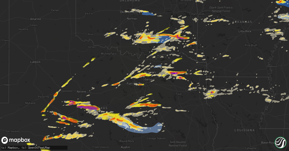
Hail Map on May 22, 2024
Get this storm
May 22 map
$229
one time, instant access
Download today. No call, no setup
Keep the $229
Bought the map and want the full workflow? Apply the entire $229 to a subscription within 7 days. None of it is wasted.
Every map, not just this one
This buys you this map. Subscription and you get every map we run, in the markets you choose from a few cities to whole states to nationwide. Plus real-time alerts the moment a storm fires.
Contact data
Name, contact info, occupancy, even credit band for addresses in the footprint. You go from where it hit to who to call.
Become the source they trust
Unlimited branding weather history reports on demand. You already have the documented answer ready for the property owner, and you are the one who showed up with it.
Property data and RoofTrace estimates
Pull up any address you have got, its value and the exact code rules for that jurisdiction, straight from One Click Code. Then RoofTrace estimates the squares, pitch, and roof value, priced the way you price.
States Impacted by Hail Map on May 22, 2024
Storm reports
West Virginia
| Date | Description |
|---|---|
| 05/22/20243:15 PM CDT | Quarter-size hail was observed along waiteville road. |
| 05/22/20242:14 PM CDT | Multiple trees reported down. At least one tree reported down on a home. Time estimated by radar. |
| 05/22/20242:10 PM CDT | Trees down on state route 34 in the area of lake hollow road. |
| 05/22/20242:10 PM CDT | Tree reported down. Time is estimated by radar. |
| 05/22/20242:02 PM CDT | Tree reported down. Time estimated by radar. Tn 3650 8449 several trees down across the county. |
| 05/22/20242:02 PM CDT | Tree reported down. Time estimated by radar. |
| 05/22/20241:45 PM CDT | A local report indicates 1.75 inch wind near 1 NE Milton |
| 05/22/20241:32 PM CDT | Hail damage to cars. Photos showing hail on ground provided. |
| 05/22/20241:32 PM CDT | Numerous trees down throughout lesage including at the riveria golf course and in the grand meadows subdivision. There were roofs blown off of two houses. Photos showin |
| 05/22/20241:25 PM CDT | Mul |
| 05/22/20241:25 PM CDT | Multiple trees down... Along with power lines. |
Kentucky
| Date | Description |
|---|---|
| 05/22/20246:36 PM CDT | Tree down at 2590 hwy 79. |
| 05/22/20245:45 PM CDT | One large oak tree and two smaller trees down on a house on winkler lane in philpot. Time estimated from radar. |
| 05/22/20244:06 PM CDT | A local report indicates 1.00 inch wind near Monticello |
| 05/22/20244:06 PM CDT | Tree down on a car and reports of other trees down around monticello relayed through x. Time estimated by radar and previous report. |
| 05/22/20244:02 PM CDT | A local report indicates 58 MPH wind near Benton |
| 05/22/20244:01 PM CDT | A few large trees down around benton. |
| 05/22/20243:50 PM CDT | Tree down on the southeast side of benton. |
| 05/22/20241:00 PM CDT | Several large trees were downed on highway 163... Along with power lines. Time estimated from radar. |
| 05/22/202412:52 PM CDT | Several areas in flatwoods observed downed trees and power lines. These included wilburn street... Crestwood court... Cumberland avenue... Beth ann drive... Mullins str |
| 05/22/202412:50 PM CDT | Numerous areas of tree and power line damage in the raceland area. These included armada boulevard... Caroline road... Rams boulevard... Brown street... Belmont road... |
| 05/22/202412:47 PM CDT | Scoreboard damaged at raceland high school. |
| 05/22/202412:45 PM CDT | Multiple neighborhoods observed tree and power line damage near us 23... Including wurtland avenue... Virginia street... Heaberlin road... Chinns branch road... Clark l |
| 05/22/202412:45 PM CDT | Tree down. Blocking roadway. Time estimated from radar. |
| 05/22/202412:44 PM CDT | Tree on garage along with power lines down along oak street. Trees and power lines also down along ridge road. Trees down along ferry street and high street. Time estim |
| 05/22/202412:44 PM CDT | Trees and power lines down along brenda sue drive. Time estimated from radar. |
| 05/22/202412:40 PM CDT | Tree down across state route 1459 in little sandy. |
| 05/22/202412:25 PM CDT | Microburst with winds up to 90 mph occurred along mckay rd... Uprooting or snapping multiple trees in a northwest to southeast direction. |
| 05/22/202412:24 PM CDT | Trees down along stewart ave and pond run road. |
| 05/22/202412:18 PM CDT | Trees down. |
| 05/22/202412:12 PM CDT | Several trees down. |
| 05/22/202412:08 PM CDT | 3 trees down along state route 7. Time estimated from radar. |
| 05/22/20246:56 AM CDT | Both nickel and quarter sized hail from relayed video. |
Indiana
| Date | Description |
|---|---|
| 05/22/20246:09 PM CDT | Tree down at lovers ln and prewitt ln. |
| 05/22/20245:57 PM CDT | Tree down over chestnut grove road. |
| 05/22/20245:57 PM CDT | Tree down on state road 237 just south of mozart street. |
| 05/22/20245:54 PM CDT | Tree down on a house. |
| 05/22/20245:51 PM CDT | Multiple reports of tree damage from 2nd street and washington street within scottsburg city limits. At least one power line down in the road as well. |
Pennsylvania
| Date | Description |
|---|---|
| 05/22/20246:09 PM CDT | 5 trees down. |
| 05/22/20244:25 PM CDT | Corrects previous tstm wnd dmg report from 3 ene leonard harrison state park. 5 trees down. |
| 05/22/20244:25 PM CDT | 5 trees down. |
| 05/22/20244:25 PM CDT | 5 trees down. |
| 05/22/20243:20 PM CDT | Tree down across rt 120 near anderson rd. |
| 05/22/20242:55 PM CDT | Numerous trees down in fox twp including along toby rd. |
| 05/22/20241:52 PM CDT | Trees down and blocking the intersection of long run rd. And spruce run rd. |
| 05/22/20241:51 PM CDT | Trees on wires and blocking the intersection of haven pine rd. And long run rd. |
| 05/22/20241:50 PM CDT | Trees across the east bound lanes of interstate 80 near mile marker 177. |
| 05/22/20241:20 PM CDT | Trees down on wires. |
| 05/22/20241:02 PM CDT | Multiple trees and wires down just north of mifflintown exit of route 322. |
| 05/22/202412:53 PM CDT | Multiple trees down. |
| 05/22/202411:46 AM CDT | Large tree down on fairmount pwky. Time estimated via radar. |
| 05/22/202411:45 AM CDT | Large tree branch down on parkside drive. |
| 05/22/202411:40 AM CDT | Trees down at 1700 block of fairmount parkway between e. 35th and old french. |
| 05/22/202411:15 AM CDT | Tree down on ridge rd. |
| 05/22/202411:08 AM CDT | Multiple trees down. |
| 05/22/202411:08 AM CDT | Multiple trees down. |
| 05/22/202410:55 AM CDT | Tree down on shady avenue. |
| 05/22/202410:40 AM CDT | Tree down onto vehicle on us highway 322 with entrapment. |
| 05/22/20246:43 AM CDT | Several trees down between timber rd and forest rd including a tree on a home and a tree on a garage. |
| 05/22/20246:42 AM CDT | Multiple tree trunks snapped on summer hill rd 0.2 miles west of pa rte 183. |
| 05/22/20245:31 AM CDT | Multiple power poles down along point township drive. |
| 05/22/20245:25 AM CDT | Tree down on wires on susquehanna trail near the intersection of 14th street. |
| 05/22/20244:45 AM CDT | Multiple reports of trees and wires down. |
| 05/22/20244:12 AM CDT | Large tree down in jackson township. |
| 05/22/20244:10 AM CDT | Trees and wires down at the intersection of charter oak rd and mcalveys fort road. |
| 05/22/20244:03 AM CDT | Numerous trees snapped and uprooted in the stone valley forest. |
| 05/22/20242:38 AM CDT | Multiple trees down across western johnstown... Some into residences. |
| 05/21/202410:30 PM CDT | Downed tree on wilson rd in greenfield township. |
Idaho
| Date | Description |
|---|---|
| 05/22/20244:00 PM CDT | Tom cat summit itd site. |
Oklahoma
| Date | Description |
|---|---|
| 05/22/20242:22 PM CDT | Quarter to ping pong ball size hail fell near carter mountain... Near the intersection of highway 259 and timbuktu trail. |
| 05/22/20241:32 PM CDT | Ping-pong ball to golf ball size hail. |
| 05/22/20241:31 PM CDT | A local report indicates 2.00 inch wind near Clayton |
| 05/22/20241:21 PM CDT | A local report indicates 1.00 inch wind near 2 SW Calera |
| 05/22/20241:11 PM CDT | Wards chapel road... Tree down taking a power line with it. |
| 05/22/202412:55 PM CDT | A local report indicates 1.00 inch wind near 3 SW TEST MLC Tent Site |
| 05/22/202412:46 PM CDT | A local report indicates 1.00 inch wind near 1 NE Savanna |
| 05/22/202412:33 PM CDT | Report from mping: quarter |
| 05/22/202411:00 AM CDT | Several large trees down in field north of lane. Video from fb. Time is estimated. |
| 05/22/202410:39 AM CDT | A local report indicates 70 MPH wind near 2 NW Atoka |
| 05/22/202410:35 AM CDT | A local report indicates 1.00 inch wind near Lehigh |
| 05/22/202410:10 AM CDT | Report from mping: half dollar |
| 05/22/202410:05 AM CDT | A local report indicates 1.75 inch wind near 1 NNW Pontotoc |
| 05/22/20249:50 AM CDT | Two power poles snapped. Relayed by koco tv. |
| 05/22/20249:44 AM CDT | Single family home with damage. |
| 05/22/20249:43 AM CDT | Tree damage observed in quinton. |
| 05/22/20249:39 AM CDT | Report of trees down in the area from strong thunderstorm winds. |
| 05/22/20249:38 AM CDT | A tornado uprooted trees... Damaged the roofs of homes... And snapped power poles. |
| 05/22/20249:19 AM CDT | Corrects previous tstm wnd dmg report from crowder. Report of trees down in the area from strong thunderstorm winds. |
| 05/22/20247:40 AM CDT | A local report indicates 59 MPH wind near 3 NNW Shawnee |
| 05/22/20246:16 AM CDT | Tree down on panki bok road in eagletown. Report from broken bow 911. |
| 05/22/20245:42 AM CDT | Several trees were downed near millerton. |
| 05/22/20242:08 AM CDT | Report from mping: quarter |
| 05/22/20242:05 AM CDT | Phone report. Radar estimated time. |
| 05/22/202412:30 AM CDT | Report from mping: quarter |
Arkansas
| Date | Description |
|---|---|
| 05/22/20244:25 PM CDT | Tree down on hempstead county road 252 in de ann community. |
| 05/22/20243:35 PM CDT | A local report indicates 1.00 inch wind near Whelen Springs |
| 05/22/20242:43 PM CDT | Multiple trees down in the cypert community near cr 606 and hwy 318. |
| 05/22/20242:12 PM CDT | 8 power poles knocked down on u.s. 61 between osceola and blytheville. |
| 05/22/20242:01 PM CDT | Powerlines down in marion near carter dr. |
| 05/22/20241:55 PM CDT | Corrects previous tstm wnd dmg report from 2 wsw luxora. Large tree uprooted... Heavy farm machinary overturned... And damage to a metal outbuilding. |
| 05/22/20241:55 PM CDT | Powerpoles down between brickeys and marianna. |
| 05/22/20241:55 PM CDT | Large tree down. |
| 05/22/20241:40 PM CDT | A local report indicates 1.00 inch wind near Marianna |
| 05/22/20241:28 PM CDT | Trees and powerlines down north of caraway. Time estimated by radar. |
| 05/22/20241:03 PM CDT | A local report indicates 1.00 inch wind near 1 E Harrisburg |
| 05/22/20241:02 PM CDT | A local report indicates 1.50 inch wind near 3 WSW Brookland |
| 05/22/20241:00 PM CDT | Asos station kjbr jonesboro. |
| 05/22/20241:00 PM CDT | Numerous trees and minor damage to some home and businesses across jonesboro. |
| 05/22/202412:59 PM CDT | A local report indicates 1.75 inch wind near 1 NNE Jonesboro |
| 05/22/202412:57 PM CDT | Golf ball sized hail reported at hobby lobby in jonesboro. |
| 05/22/202412:45 PM CDT | Several utility poles down along highway 349. |
| 05/22/20246:44 AM CDT | A tree was downed in winthrop. |
Ohio
| Date | Description |
|---|---|
| 05/22/20246:40 PM CDT | A local report indicates 1.00 inch wind near 2 N Tipp City |
| 05/22/20246:29 PM CDT | A local report indicates 1.00 inch wind near Potsdam |
| 05/22/20241:15 PM CDT | The roof of a mobile home was blown off along township road 309 in chesapeake. |
| 05/22/202412:57 PM CDT | Tree reported down. |
| 05/22/202412:52 PM CDT | Tree reported down into a transformer. |
| 05/22/202412:50 PM CDT | Large 30 to 40 foot maple tree down on a residence. Time estimated from radar. |
| 05/22/202412:50 PM CDT | Windows blow out of a business in downtown ironton. Time estimated from radar. |
| 05/22/202412:50 PM CDT | Tree down in front of house between adams and jefferson streets... And a large tree limb barley hanging at spruce and 6th streets. Time estimated from radar. |
| 05/22/202412:24 PM CDT | Large tree uprooted... Damaging house on walburn ave. |
| 05/22/202412:23 PM CDT | Numerous trees and large branches down in the franklin furnace area. |
| 05/22/20241:00 AM CDT | Trees down along teagarden road. |
| 05/21/20249:03 PM CDT | Trees and wires down. |
| 05/21/20249:01 PM CDT | Trees down on w. Streetsboro road between stine road and ridgeway street. |
| 05/21/20249:00 PM CDT | Faio1 fairport... Oh. |
| 05/21/20248:56 PM CDT | Tree through a roof. |
| 05/21/20248:55 PM CDT | Tree down. |
| 05/21/20248:52 PM CDT | Trees and wires down. |
| 05/21/20248:52 PM CDT | Tree and wires down. |
| 05/21/20248:11 PM CDT | A local report indicates 1.00 inch wind near 1 W Bay Village |
| 05/21/20248:04 PM CDT | Report from mping: quarter |
| 05/21/20247:58 PM CDT | A local report indicates 1.00 inch wind near 1 NNE Avon |
| 05/21/20247:56 PM CDT | A local report indicates 1.00 inch wind near North Fairfield |
| 05/21/20247:48 PM CDT | Trees down. |
| 05/21/20247:46 PM CDT | A local report indicates 1.00 inch wind near 1 SSW Elyria |
| 05/21/20247:39 PM CDT | Two large trees snapped and uprooted. Flag pole also bent at the base. |
| 05/21/20247:37 PM CDT | Tree down on state route 96. |
| 05/21/20247:37 PM CDT | Camper completely destroyed with parts of it tossed 50 to 60 feet into a field. |
| 05/21/20247:35 PM CDT | A local report indicates 1.25 inch wind near Marion |
| 05/21/20247:33 PM CDT | A local report indicates 1.00 inch wind near Wakeman |
| 05/21/20247:31 PM CDT | A local report indicates 1.00 inch wind near Wakeman |
| 05/21/20247:28 PM CDT | A local report indicates 1.00 inch wind near 1 N Bucyrus |
| 05/21/20247:20 PM CDT | Tree down on power line. |
| 05/21/20247:10 PM CDT | A local report indicates 1.25 inch wind near 3 E Harpster |
New Jersey
| Date | Description |
|---|---|
| 05/22/20246:05 AM CDT | Mesonet station nj54 cream ridge. |
| 05/22/20246:02 AM CDT | Some trees down in parts of vernon township. Time estimated from radar. |
| 05/22/20245:58 AM CDT | Trees down around the crystal springs resort in hamburg. Time estimated from radar. |
| 05/22/20245:57 AM CDT | Route 23 all lanes closed at route 94 in hamburg due to downed tree and wires. Time estimated from radar. |
| 05/22/20245:57 AM CDT | Power poles and trees down in hamburg along route 94. Probable microburst. Time estimated from radar. |
New York
| Date | Description |
|---|---|
| 05/22/20245:31 PM CDT | Trees and wires down on whitetail dr. |
| 05/22/20245:18 PM CDT | Tree down across cemetery rd. |
| 05/22/20245:18 PM CDT | Tree down across cemetery rd. ( |
| 05/22/20245:16 PM CDT | Trees down on watson rd. |
| 05/22/20245:06 PM CDT | Tree down over road... Reported on social media. |
| 05/22/20245:03 PM CDT | Picture of metal road sign down... Reported on social media. |
| 05/22/20244:52 PM CDT | Trees down on marmon rd. |
| 05/22/20244:49 PM CDT | Multiple trees down reported on social media. |
| 05/22/20244:48 PM CDT | Large tree down... Reported on social media. |
| 05/22/20244:42 PM CDT | A tree... Utility pole... And wires down on lansing place. |
| 05/22/20244:39 PM CDT | Trees and wires down. |
| 05/22/20244:30 PM CDT | Wires down. |
| 05/22/20244:27 PM CDT | Tree down across road. |
| 05/22/20244:25 PM CDT | Tree down on road. |
| 05/22/20244:23 PM CDT | Tree and wires down on capron rd near weaver rd. |
| 05/22/20244:22 PM CDT | Trees and wires down. |
| 05/22/20244:20 PM CDT | Tree down over road. |
| 05/22/20244:19 PM CDT | Tree down over road. |
| 05/22/20244:17 PM CDT | Corrects previous tstm wnd dmg report from 2 ese brewerton. Tree down across road. |
| 05/22/20244:17 PM CDT | Corrects previous tstm wnd dmg report from 1 nw jamesville. Wires down. |
| 05/22/20244:13 PM CDT | Trees and wires down on pumphouse rd. |
| 05/22/20244:10 PM CDT | Tree down over road. |
| 05/22/20244:06 PM CDT | Tree on wires. |
| 05/22/20244:06 PM CDT | Corrects previous tstm wnd dmg report from 1 wnw greene. Trees and wires down. |
| 05/22/20244:04 PM CDT | Corrects previous tstm wnd dmg report from 1 wsw nedrow. Trees and wires down. |
| 05/22/20244:02 PM CDT | Broken telephone pole. |
| 05/22/20243:58 PM CDT | Corrects previous tstm wnd dmg report from 1 ne onondaga. Tree down over road. |
| 05/22/20243:58 PM CDT | Corrects previous tstm wnd dmg report from 2 se marcellus. Picture of metal road sign down... Reported on social media. |
| 05/22/20243:55 PM CDT | Corrects previous tstm wnd dmg report from 1 n lakeland. Tree down on road. |
| 05/22/20243:53 PM CDT | Corrects previous tstm wnd dmg report from skaneateles. Broken telephone pole. |
| 05/22/20243:53 PM CDT | Corrects previous tstm wnd dmg report from 1 nw onondaga. Tree down over road. |
| 05/22/20243:47 PM CDT | Trees and wires down on gifford rd near county route 7. |
| 05/22/20243:45 PM CDT | Quarter size hail reported on social media. |
| 05/22/20243:44 PM CDT | Corrects previous tstm wnd dmg report from 2 s jacks reef. Tree on wires. |
| 05/22/20243:42 PM CDT | Tree down on wires... Causing fire. |
| 05/22/20243:39 PM CDT | Pictures shared on social media show a couple of large trees down and a small pavilion partially collapsed. |
| 05/22/20243:39 PM CDT | Pictures shared on social media show a couple of large trees down and a small pavilion partially collapsed. |
| 05/22/20243:38 PM CDT | Tree down on property. |
| 05/22/20243:31 PM CDT | Corrects previous tstm wnd dmg report from 2 w auburn. Tree down on wires... Causing fire. |
| 05/22/20243:25 PM CDT | Report from mping: 1-inch tree limbs broken; shingles blown off. |
| 05/22/20243:11 PM CDT | Tree down on cedar swamp road blocking both lanes. |
| 05/22/20243:10 PM CDT | Corrects previous hail report from 2 sse bethel. Quarter size hail reported on social media. |
| 05/22/20243:06 PM CDT | Tree down onto a porch on marbletown road. |
| 05/22/20243:06 PM CDT | Trees and wires down... Property damage reported. |
| 05/22/20243:03 PM CDT | Tree and wires down. |
| 05/22/20243:03 PM CDT | Trees and wires down. |
| 05/22/20243:02 PM CDT | Tree down on welch road. |
| 05/22/20243:01 PM CDT | Tree down on ketchum road. |
| 05/22/20242:59 PM CDT | Corrects previous tstm wnd dmg report from 1 s milo center. Tree and wires down. |
| 05/22/20242:54 PM CDT | Corrects previous tstm wnd dmg report from penn yan. Trees and wires down. |
| 05/22/20242:54 PM CDT | Tree fallen on home... Reported damage to home. Wires also over the road. |
| 05/22/20242:48 PM CDT | Corrects previous tstm wnd dmg report from montour falls. Tree down over road... Reported on social media. |
| 05/22/20242:23 PM CDT | Tree across townline and wheeler station road. |
| 05/22/20241:04 PM CDT | Large tree and power lines down on norway place. Time estimated by radar. |
| 05/22/202412:57 PM CDT | Trees uprooted or snapped. |
| 05/22/202412:25 PM CDT | A few trees down in the fredonia area. Down on new harmony road. In addition... A couple trees down alo |
| 05/22/202412:25 PM CDT | A few trees down in the fredonia area. |
| 05/22/202411:53 AM CDT | A few trees down in the lakewood area. |
| 05/22/20246:50 AM CDT | Corrects previous hail report from peekskill. 1.5 inch hail reported. |
| 05/22/20246:50 AM CDT | Corrects previous hail report from 1 nw croton-on-hudson. 1.5 hail reported. |
| 05/22/20246:50 AM CDT | 1.5 inch hail reported. |
| 05/22/20246:50 AM CDT | 1.5 inch hail reported. |
| 05/22/20246:42 AM CDT | One inch hail reported on albany post road off us-9. |
| 05/22/20246:42 AM CDT | Downed tree on albany post road. Us-9 ramp closed. |
| 05/22/20246:42 AM CDT | Corrects previous tstm wnd dmg report from 1 ese montrose. Downed tree on albany post road. Us-9 ramp closed. |
| 05/22/20246:42 AM CDT | Corrects previous hail report from 1 ese montrose. Quarter inch hail reported on albany post road off us-9. |
| 05/22/20246:30 AM CDT | Downed tree on long meadow road. |
| 05/22/20246:30 AM CDT | Multiple trees down across greenwood lake. |
| 05/22/20246:30 AM CDT | Wires down on seven lakes drive. Road closed. |
| 05/22/20246:30 AM CDT | Corrects previous tstm wnd dmg report from 4 nw wesley hills. Wires down on seven lakes drive. Road closed. |
| 05/22/20246:30 AM CDT | Multiple trees down on power lines on ny-17a and windermere avenue. |
| 05/22/20246:25 AM CDT | Multiple trees down across the south portion of town on stoneleigh ave... Drewville rd... Weber hill rd... And seminary hill rd near willow rd. |
Virginia
| Date | Description |
|---|---|
| 05/22/20245:13 PM CDT | Tree downed by thunderstorm winds on troutdale highway. |
| 05/22/20245:04 PM CDT | Tree downed by thunderstorm winds near the intersection of highland parkway and sturgills road. |
| 05/22/20244:59 PM CDT | Tree downed by thunderstorm winds on us 58 near helton creek lane. |
| 05/22/20244:14 PM CDT | Numerous hailstones at least the size of a quarter at watkins market on bradshaw road. |
| 05/22/20244:02 PM CDT | Several trees blown down between the 4000 and 5000 block of bradshaw road. Nickel size hail also reported. Fallen trees damaged some fencing. |
| 05/22/20244:02 PM CDT | A few quarter sized hailstones on blacksburg road. |
| 05/22/20244:01 PM CDT | A few trees were blown down about 3 miles southwest of us 311 along blacksburg road. |
| 05/22/20242:44 PM CDT | Trees down at the 1300 block of stony hill road. |
| 05/22/20241:55 PM CDT | Report via social media... Quarter sized hail covering the ground on mitchells crossing road. |
Wisconsin
| Date | Description |
|---|---|
| 05/22/20246:18 PM CDT | Tree down near the intersection o |
| 05/22/20246:18 PM CDT | Tree down near the intersection of chestnut ave. And kellogg st. In the city of green bay. Reported via facebook. |
Louisiana
| Date | Description |
|---|---|
| 05/22/20246:59 PM CDT | Reported in chasewood subdivision. |
| 05/22/20246:48 PM CDT | Reported in the deepwoods subdivision. |
| 05/22/20246:30 PM CDT | Hail reported near keithville c |
| 05/22/20246:30 PM CDT | Hail reported near keithville community at colquitt road and freedoms way. |
| 05/21/202410:05 PM CDT | Viewer sent photo of large tree down in back yard via ktve social media. |
| 05/21/20249:20 PM CDT | Bienville parish sheriff reports tree down on interstate 20 near mile marker 74. |
| 05/21/20249:20 PM CDT | Bienville parish sheriff reports tree down on interstate 20 near mile marker 74. ( |
| 05/21/20248:35 PM CDT | Tree and power lines down near intersection of harrison and mitcham orchard road. |
| 05/21/20248:35 PM CDT | Tree down across jinks road. |
| 05/21/20247:47 PM CDT | Reported at kbad. |
| 05/21/20247:30 PM CDT | A brief and short ef-1 tornado with peak winds estimated at 97 mph occurred along the north side of highway 527... Just west of red chute bayou. Damage occurred to a fe |
| 05/21/20247:08 PM CDT | Reported off of youree drive near stratmore drive in southeast shreveport. |
| 05/21/20247:03 PM CDT | Large hail reported in deepwoods subdivision. Also... Estimated 60 mph winds. |
| 05/21/20247:01 PM CDT | Reported just north of intersection of mansfield road inner loop 3132. |
| 05/21/20247:00 PM CDT | Sheriff office sent photo of hail near meriwether and walker road intersection. |
Tennessee
| Date | Description |
|---|---|
| 05/22/20246:57 PM CDT | Several trees down. |
| 05/22/20246:57 PM CDT | Corrects previous tstm wnd dmg report from 8 ese huntsville. Corrects previous tstm wnd dmg report from 3 ese huntsville. Several trees down. |
| 05/22/20246:35 PM CDT | Several trees down across the county. |
| 05/22/20246:30 PM CDT | Trees down and small hail. |
| 05/22/20245:54 PM CDT | Damage reported across southern portions of marshall county... Including several trees down with some homes damaged. |
| 05/22/20245:54 PM CDT | Reports of some trees down in the cornersville area. |
| 05/22/20245:29 PM CDT | Multiple trees reported down in the area. |
| 05/22/20245:15 PM CDT | A few metal roofs blown off structures. Several trees down. Delayed report. |
| 05/22/20245:14 PM CDT | A few trees down. Report and video received via facebook. |
| 05/22/20244:47 PM CDT | Trees reported down south of highway 52. |
| 05/22/20244:36 PM CDT | Several trees down on new harmony road. In addition... A couple trees down along highway 52. |
| 05/22/20243:48 PM CDT | Trees down across the roadway on highway 104. Time is radar estimated. |
| 05/22/20243:28 PM CDT | Media report of a tree fallen on a home on myra court in pleasant view. Time is radar estimated. |
| 05/22/20243:10 PM CDT | Weakley county emergency management reports a large tree was down in dresden... Tn. Time estimated based on radar. |
| 05/22/20243:09 PM CDT | Several trees down along hwy 412. |
| 05/22/20243:07 PM CDT | Public reports powerlines down in humboldt... Tn. |
| 05/22/20243:03 PM CDT | A couple of trees and a power pole down on harts bridge road. Time is radar estimated. |
| 05/22/20243:00 PM CDT | Trees down across pipkin road near shadow ridge drive. |
| 05/22/20242:43 PM CDT | Large oak tree snapped on brantley road. Time estimated by radar. |
| 05/22/20242:35 PM CDT | Several trees down. Time estimated by radar. |
| 05/22/20242:35 PM CDT | Numerous trees down across the northeast part of the county. Trees down at intersection of edith nankipoo road and cook road. Time is radar estimated. |
| 05/22/20242:24 PM CDT | A local report indicates 1.00 inch wind near 1 NE Midtown Memphis |
| 05/22/202412:43 PM CDT | Multiple motorists reporting quarter size hail along hwy51 between troy and union city. |
| 05/22/202412:24 PM CDT | A local report indicates 1.00 inch wind near 3 WNW Ellendale |
| 05/21/20247:24 PM CDT | Several trees down. |
Texas
| Date | Description |
|---|---|
| 05/22/20246:55 PM CDT | Report from mping: quarter |
| 05/22/20246:53 PM CDT | Report from mping: ping pong ball |
| 05/22/20246:40 PM CDT | Reported by public via kltv facebook near intersection of hynson springs road and fm road 450. |
| 05/22/20246:37 PM CDT | Report from mping: ping pong ball |
| 05/22/20246:35 PM CDT | Destroyed mobile home... Along with part of a roof off a home off highway 53 between zabcikville and seaton. Time estimated. |
| 05/22/20246:35 PM CDT | Corrects previous hail report from 9 nne rogers. Destroyed mobile home... Along with part of a roof off a home off highway 53 between zabcikville and seaton. Time estim |
| 05/22/20246:35 PM CDT | Damage to planes at ktpl airport in temple. One plane flipped over... Another one blown into a ditch... Other debris scattered about. |
| 05/22/20246:33 PM CDT | Ef-1 damage was found on the southeast side of temple off of fm 3117. Maximum estimated winds are 95 mph. |
| 05/22/20246:30 PM CDT | Reported in diana community. |
| 05/22/20246:30 PM CDT | Correction...hail quarter to ping pong size reported in diana community from public photos and amateur radio. |
| 05/22/20246:29 PM CDT | Social media video and images of damage to temple mall... Including large windows blown out and damage to walls. Time estimated via radar. |
| 05/22/20246:25 PM CDT | Roof damage to homes and power poles snapped. Time estimated. |
| 05/22/20246:25 PM CDT | Report from mping: quarter |
| 05/22/20246:24 PM CDT | Video relayed by broadcast media of a tornado moving through the parks of westfield area of temple. Time estimated via radar. |
| 05/22/20246:23 PM CDT | Report from mping: ping pong ball |
| 05/22/20246:21 PM CDT | *** 30 inj *** ef-2 damage was found in west temple with maximum estimated winds of 120 mph. |
| 05/22/20246:20 PM CDT | Damaged metal barn in bruceville-eddy. Time estimated. |
| 05/22/20246:20 PM CDT | Social media photos. Damage to several commercial buildings near w adams and hilliard rd. Time estimated. |
| 05/22/20246:11 PM CDT | 76 mph measured at khlr. |
| 05/22/20246:03 PM CDT | Most stones between 1 and 1.25 with max 1.75. |
| 05/22/20246:00 PM CDT | Trees down on fm road 1448. |
| 05/22/20245:47 PM CDT | Photo of hail in leesburg community via kltv facebook page. |
| 05/22/20245:40 PM CDT | A local report indicates 1.00 inch wind near 1 ESE Mertzon |
| 05/22/20245:35 PM CDT | A local report indicates 1.25 inch wind near 3 NE Knickerbocker |
| 05/22/20245:32 PM CDT | Trained spotter reports quarter size hail 1 mile ne of downtown winnsboro on fm 1448. |
| 05/22/20245:32 PM CDT | Public photo via kltv facebook of hail on county road 4420 near the winnsboro and scroggins area. |
| 05/22/20245:32 PM CDT | A local report indicates 1.75 inch wind near 4 NW Vancourt |
| 05/22/20245:30 PM CDT | A local report indicates 1.00 inch wind near 2 W Wall |
| 05/22/20245:28 PM CDT | A local report indicates 1.25 inch wind near 6 NW Capitola |
| 05/22/20245:26 PM CDT | A local report indicates 1.00 inch wind near Mertzon |
| 05/22/20245:25 PM CDT | Numerous trees down in and around the winnsboro area. |
| 05/22/20245:20 PM CDT | A local report indicates 2.50 inch wind near Wingate |
| 05/22/20245:02 PM CDT | A local report indicates 1.50 inch wind near 3 W San Angelo |
| 05/22/20244:58 PM CDT | A local report indicates 1.75 inch wind near 3 WSW San Angelo |
| 05/22/20244:55 PM CDT | Report from mping: half dollar |
| 05/22/20244:54 PM CDT | A local report indicates 2.00 inch wind near 4 WSW San Angelo |
| 05/22/20244:53 PM CDT | A local report indicates 1.00 inch wind near 4 W San Angelo |
| 05/22/20244:32 PM CDT | A local report indicates 1.00 inch wind near Colorado City |
| 05/22/20244:26 PM CDT | Reported in lake colorado city. |
| 05/22/20244:25 PM CDT | Report from mping: ping pong ball |
| 05/22/20244:20 PM CDT | Report from mping: ping pong ball |
| 05/22/20244:20 PM CDT | Golf ball size hail south of mineral wells. |
| 05/22/20244:20 PM CDT | 1 in hail. |
| 05/22/20244:13 PM CDT | Report from mping: quarter |
| 05/22/20244:13 PM CDT | Report from mping: quarter |
| 05/22/20244:13 PM CDT | A local report indicates 1.00 inch wind near 13 SW Colorado City |
| 05/22/20244:10 PM CDT | Storm chaser video showing tornado on the ground. Location estimated by radar. |
| 05/22/20244:02 PM CDT | Report from mping: quarter |
| 05/22/20244:02 PM CDT | Report from mping: quarter |
| 05/22/20243:50 PM CDT | A local report indicates 1.00 inch wind near 3 S Lake Brownwood |
| 05/22/20243:43 PM CDT | Storm spotter measured a wind gust of 66.7 mph. |
| 05/22/20243:36 PM CDT | Law enforcement confirmed tornado on the ground about the cross highway 163 s. |
| 05/22/20243:18 PM CDT | A local report indicates 1.75 inch wind near Coleman |
| 05/22/20243:11 PM CDT | 1.25 in hail coit and legacy. |
| 05/22/20243:10 PM CDT | Coleman fire chief reported multiple utility poles down. Time and location estimated by radar. |
| 05/22/20243:10 PM CDT | A local report indicates 1.50 inch wind near Coleman |
| 05/22/20243:00 PM CDT | A local report indicates 1.00 inch wind near 1 NNE Glen Cove |
| 05/22/20242:59 PM CDT | Report from mping: quarter |
| 05/22/20242:49 PM CDT | 1 in hail corner of preston and legacy. |
| 05/22/20242:48 PM CDT | Report from mping: quarter |
| 05/22/20242:46 PM CDT | Power lines down over the highway. Winds estimated to be 70 mph. |
| 05/22/20242:45 PM CDT | Report from mping: quarter |
| 05/22/20242:40 PM CDT | Report from mping: quarter |
| 05/22/20242:39 PM CDT | 1 in hail srt and preston. |
| 05/22/20242:38 PM CDT | 1 in hail in the colony. |
| 05/22/20242:30 PM CDT | Photo on twitter. |
| 05/22/20242:23 PM CDT | 68 mph wind gust. |
| 05/22/20242:20 PM CDT | Report from mping: quarter |
| 05/22/20242:14 PM CDT | Report from mping: ping pong ball |
| 05/22/20242:09 PM CDT | Report from mping: quarter |
| 05/22/20242:08 PM CDT | 1 in hail in flower mound. |
| 05/22/20242:05 PM CDT | Report from mping: quarter |
| 05/22/20241:55 PM CDT | 1 in hail in frisco lakes. |
| 05/22/20241:43 PM CDT | Report from mping: half dollar |
| 05/22/20241:43 PM CDT | A local report indicates 1.00 inch wind near Wingate |
| 05/22/20241:28 PM CDT | Report from mping: quarter |
| 05/22/20241:28 PM CDT | Report from mping: quarter |
| 05/22/20241:26 PM CDT | Report from mping: quarter |
| 05/22/20241:20 PM CDT | A local report indicates 2.75 inch wind near 10 N Bronte |
| 05/22/20241:14 PM CDT | Report from mping: quarter |
| 05/22/20241:13 PM CDT | Time estimated by radar. |
| 05/22/20241:09 PM CDT | 1 in hail in flower mound. |
| 05/22/20241:05 PM CDT | 1 in hail in van alstyne. |
| 05/22/20241:01 PM CDT | Report from mping: quarter |
| 05/22/202412:36 PM CDT | Report from mping: quarter |
| 05/22/202412:27 PM CDT | Quarter size hail s of cottondate. |
| 05/22/202412:39 AM CDT | Corrects previous hail report from 1 e ennis. Report from mping: quarter |
| 05/21/202410:11 PM CDT | Report from mping: half dollar |
| 05/21/202410:10 PM CDT | Half dollar sized hail reported near fm 1713 at fm 933 north of whitney. |
| 05/21/20249:40 PM CDT | Trees and power lines reported down in several areas of the county... Including the city of nacogdoches. In western portion of the county on hwy 225 near douglass... Co |
| 05/21/20249:30 PM CDT | Tree down on stoddard drive. |
| 05/21/20249:30 PM CDT | Large tree uprooted at intersection of austin and raguet streets. The tree damaged the adjacent traffic lights. |
| 05/21/20249:30 PM CDT | Tree down on power lines on county road 2041. |
| 05/21/20249:25 PM CDT | Rusk county deputy reports tree down at us highway 84 and fm road 225 intersection. |
| 05/21/20249:00 PM CDT | County dispatch reports of severa |
| 05/21/20249:00 PM CDT | County dispatch reports of several trees down near grapeland due to strong winds from thunderstorms. |
| 05/21/20248:45 PM CDT | Numerous trees and powerlines down along hwy 294 from elkhart to slocum. Reports of trees fallen on homes and vehicles. Time estimated from radar. |
| 05/21/20248:42 PM CDT | Photo of hail near quarter size via kltv facebook. |
| 05/21/20248:35 PM CDT | Tree fell onto a house near highway 294 and fm 2419. Time estimated. |
| 05/21/20248:33 PM CDT | Trees and power lines down near intersection lf fm road 115 and fm road 900. |
| 05/21/20248:31 PM CDT | County dispatch reports of trees down due to thunderstorms near the town of midway. |
| 05/21/20248:10 PM CDT | A local report indicates 1.00 inch wind near Blossom |
| 05/21/20248:05 PM CDT | A local report indicates 2.50 inch wind near 6 N Como |
| 05/21/20248:05 PM CDT | Corrects previous hail report from 6 n como. |
| 05/21/20248:04 PM CDT | Report from mping. |
| 05/21/20247:56 PM CDT | County dispatch reports of trees down due to thunderstorms near north zulch. |
| 05/21/20247:54 PM CDT | Report from mping. |
| 05/21/20247:53 PM CDT | Report from mping. |
| 05/21/20247:50 PM CDT | A local report indicates 1.75 inch wind near 4 NNW Sulphur Springs |
| 05/21/20247:50 PM CDT | County dispatch reports of trees down near pine tree rd and old bundick rd due to thunderstorm winds. Additional tree down on deep well rd. |
| 05/21/20247:47 PM CDT | A local report indicates 1.00 inch wind near 5 NW Sulphur Springs |
| 05/21/20247:25 PM CDT | Tree fell onto a house in kosse. Time estimated. |
| 05/21/20247:15 PM CDT | Tree down... Downed power lines... Roof off house. Time estimated. |
| 05/21/20247:08 PM CDT | Report from mping: quarter |
| 05/21/20247:05 PM CDT | Photo of dime to quarter size hail in the spring hill area of longview via kltv facebook page. |
| 05/21/20247:04 PM CDT | 60 mph reported in cameron. |
| 05/21/20247:04 PM CDT | Report from mping: quarter |
Mississippi
| Date | Description |
|---|---|
| 05/22/20243:20 AM CDT | Multiple hardwood trees were reported down on hwy 18 and a roof was blown off a shop. |
| 05/22/20242:45 AM CDT | Scattered trees down in se hinds co... Midway and old jackson rd... Wynndale rd near i-55... Dry grove south of tank rd and haley rd. |
| 05/22/20242:32 AM CDT | A few trees down... Old adams road near fields and the trace. |
| 05/22/20242:20 AM CDT | A few trees down on the e side of town. |
| 05/22/20242:10 AM CDT | Several trees down in s part of the county... Jeff david... Hankinson... Ring roads. A few power lines down as well. |
Cities Impacted by Hail Map on May 22, 2024
- Hinton, OK
- Calumet, OK
- El Reno, OK
- Yukon, OK
- Oklahoma City, OK
- Jones, OK
- Spencer, OK
- Bethany, OK
- Tulsa, OK
- Choctaw, OK
- Harrah, OK
- Nowata, OK
- Cache, OK
- Mcloud, OK
- Meeker, OK
- Lawton, OK
- Broken Arrow, OK
- Wellston, OK
- Prague, OK
- Fort Sill, OK
- Shawnee, OK
- Fletcher, OK
- Vinita, OK
- Chelsea, OK
- Elgin, OK
- Earlsboro, OK
- Seminole, OK
- Paden, OK
- Okemah, OK
- Wewoka, OK
- Cement, OK
- Cyril, OK
- Boley, OK
- Inola, OK
- Grove, OK
- Weleetka, OK
- Anderson, MO
- Tahlequah, OK
- Noel, MO
- Lanagan, MO
- Wetumka, OK
- South West City, MO
- Bartlesville, OK
- Dewey, OK
- Stilwell, OK
- Lincoln, AR
- Wann, OK
- Berryville, AR
- Elmore City, OK
- Copan, OK
- Eufaula, OK
- Coffeyville, KS
- S Coffeyville, OK
- Canehill, AR
- Westville, OK
- Morrow, AR
- Prairie Grove, AR
- Wynnewood, OK
- Pauls Valley, OK
- Huntsville, AR
- Green Forest, AR
- Alpena, AR
- Stigler, OK
- Quinton, OK
- Canadian, OK
- Stratford, OK
- Davis, OK
- Sulphur, OK
- Roff, OK
- West Fork, AR
- Evansville, AR
- Winslow, AR
- Edna, KS
- Blue Eye, MO
- Hollister, MO
- Scottsville, KY
- Mill Creek, OK
- Ada, OK
- Fitzhugh, OK
- Branson, MO
- Kinta, OK
- Whitefield, OK
- Oswego, KS
- Park Hill, OK
- Stonewall, OK
- Tishomingo, OK
- Tupelo, OK
- Mccurtain, OK
- Red Oak, OK
- Kingston, AR
- Fittstown, OK
- Coalgate, OK
- Centrahoma, OK
- Wapanucka, OK
- Atoka, OK
- Milburn, OK
- Wilburton, OK
- Compton, AR
- Ponca, AR
- Williamsfield, OH
- Glasgow, KY
- Lucas, KY
- Coleman, OK
- Kiowa, OK
- Stringtown, OK
- Pittsburg, OK
- Wardville, OK
- Jamestown, PA
- Hartstown, PA
- Lane, OK
- Daisy, OK
- Clayton, OK
- Antlers, OK
- Knob Lick, KY
- Valley Springs, AR
- Yellville, AR
- Hartville, MO
- Grovespring, MO
- Talihina, OK
- Honobia, OK
- Nashoba, OK
- Mineral Wells, TX
- Falcon, MO
- Lynchburg, MO
- Mountain Grove, MO
- Portland, TN
- Memphis, TN
- Decatur, TX
- Rhome, TX
- Snow, OK
- Augusta, AR
- Millington, TN
- Westmoreland, TN
- Lavinia, TN
- Arlington, TN
- Cedar Grove, TN
- West Memphis, AR
- Plato, MO
- Bethpage, TN
- Ponder, TX
- Weatherford, TX
- Sanger, TX
- McCrory, AR
- Tennessee Ridge, TN
- Atoka, TN
- Poolville, TX
- Ridgely, TN
- Stewart, TN
- Bruceton, TN
- Huntingdon, TN
- Krum, TX
- Erin, TN
- Stanton, TN
- Paradise, TX
- Mason, TN
- Brighton, TN
- Muse, OK
- Whitesboro, OK
- Boyd, TX
- Springtown, TX
- Silver Creek, NY
- South Shore, KY
- South Portsmouth, KY
- Collinsville, TX
- Whitesboro, TX
- Hodgen, OK
- Hollidaysburg, PA
- Irving, NY
- Hornbeak, TN
- Greenup, KY
- Franklin Furnace, OH
- Denton, TX
- Hickory Ridge, AR
- Wynne, AR
- Cherry Valley, AR
- Newark, TX
- Valley View, TX
- Swifton, AR
- Stuart, OK
- Azle, TX
- Haslet, TX
- Clarendon, AR
- Brinkley, AR
- Troy, TN
- Obion, TN
- Angola, NY
- Aubrey, TX
- Jonesboro, AR
- Bono, AR
- Cash, AR
- Ironton, OH
- Worthington, KY
- Cumberland City, TN
- Justin, TX
- Denison, TX
- De Valls Bluff, AR
- Russell, KY
- Ulm, AR
- Stuttgart, AR
- Sherman, TX
- Hendrix, OK
- Drummonds, TN
- Munford, TN
- Smithville, OK
- Fort Worth, TX
- Bay, AR
- State University, AR
- Roanoke, TX
- Brookland, AR
- Argyle, TX
- Huntingdon, PA
- Alexandria, PA
- Parkin, AR
- Kitts Hill, OH
- Flatwoods, KY
- Earle, AR
- Keller, TX
- Red Boiling Springs, TN
- Lafayette, TN
- Gamaliel, KY
- Tompkinsville, KY
- Gunter, TX
- Celina, TX
- Hamburg, NY
- Eden, NY
- Pedro, OH
- Ashland, KY
- Derby, NY
- Lake View, NY
- Pilot Point, TX
- Mcalester, OK
- Harrisburg, AR
- Fisher, AR
- Big Sandy, TN
- Williamsburg, PA
- Pottsboro, TX
- Colbert, OK
- Weiner, AR
- Rives, TN
- Union City, TN
- Robert Lee, TX
- Bronte, TX
- Scottown, OH
- Proctorville, OH
- Chesapeake, OH
- Willow Wood, OH
- South Point, OH
- Savanna, OK
- Flower Mound, TX
- Lewisville, TX
- Clyde, TX
- Dresden, TN
- Martin, TN
- Calera, OK
- Hestand, KY
- Van Alstyne, TX
- Crawfordsville, AR
- Cartwright, OK
- Marion, AR
- Clarksville, TN
- Waverly, TN
- Moro, AR
- Petersburg, PA
- Brownsville, TN
- Burkesville, KY
- Tyronza, AR
- Wingate, TX
- Turrell, AR
- Gilmore, AR
- Lake City, AR
- Durant, OK
- Caraway, AR
- Marked Tree, AR
- Leachville, AR
- Monette, AR
- Black Oak, AR
- Lesage, WV
- Huntington, WV
- Ona, WV
- Parker, PA
- McEwen, TN
- Trumann, AR
- Lock Haven, PA
- Cammal, PA
- Tioga, TX
- Crown City, OH
- Baird, TX
- Whitewright, TX
- Widener, AR
- Forrest City, AR
- Moss, TN
- Winters, TX
- Marianna, AR
- Milton, WV
- Rattan, OK
- Heth, AR
- Lake Dallas, TX
- Bells, TN
- Walnut Ridge, AR
- Holly Grove, AR
- Barboursville, WV
- Norton, TX
- Dover, TN
- Paris, TN
- Mansfield, TN
- Springville, TN
- Glenwood, WV
- Anna, TX
- Buena Vista, TN
- Camden, TN
- Ivanhoe, TX
- Telephone, TX
- Caddo, OK
- Caney, OK
- Mckinney, TX
- Bokchito, OK
- Little Elm, TX
- Frisco, TX
- The Colony, TX
- Osceola, AR
- Blytheville, AR
- Manila, AR
- Etowah, AR
- Dell, AR
- Luxora, AR
- Wilson, AR
- Keiser, AR
- Lepanto, AR
- Hurricane, WV
- Culloden, WV
- Dryden, TX
- Hillsville, VA
- Hiwassee, VA
- Dugspur, VA
- Cumberland Furnace, TN
- Cunningham, TN
- Palmyra, TN
- Albany, KY
- Ballinger, TX
- Southlake, TX
- Martinsburg, PA
- James Creek, PA
- Aubrey, AR
- Grapevine, TX
- Sumner, TX
- Vanleer, TN
- Prosper, TX
- Beech Grove, AR
- Medina, TN
- Proctor, AR
- Mill Hall, PA
- Hope, AR
- Indian Mound, TN
- Mingus, TX
- Cross Plains, TX
- Ranger, TX
- Eastland, TX
- Santo, TX
- Cisco, TX
- Gordon, TX
- Millsap, TX
- Carlsbad, TX
- Burkett, TX
- Rowena, TX
- Aledo, TX
- Miles, TX
- Lipan, TX
- Gorman, TX
- Talpa, TX
- Sheffield, TX
- Goodfellow Afb, TX
- Carbon, TX
- Coleman, TX
- Rising Star, TX
- San Angelo, TX
- Mertzon, TX
- Indian Valley, VA
- Covington, TN
- Henning, TN
- Ripley, TN
- Hemlock, NY
- Livonia, NY
- Honeoye, NY
- Bethel, OK
- Loganton, PA
- Moran, TX
- Summerville, PA
- Springwater, NY
- Oakfield, TN
- Leonard, TX
- Blue Ridge, TX
- Trenton, TX
- Hesston, PA
- Marvell, AR
- Southside, TN
- Eva, TN
- Plano, TX
- Carrollton, TX
- Halls, TN
- Gates, TN
- Friendship, TN
- Dyersburg, TN
- Broken Bow, OK
- Humboldt, TN
- Lexa, AR
- Poplar Grove, AR
- Charlotte, TN
- Celeste, TX
- Cadiz, KY
- Jersey Shore, PA
- Honey Grove, TX
- Novice, TX
- Wayland, NY
- Canandaigua, NY
- Naples, NY
- Denmark, TN
- Jackson, TN
- Moyers, OK
- Newbern, TN
- Cordova, TN
- Ashland City, TN
- Wolfe City, TX
- Saint Albans, WV
- Garden City, TX
- Ridgway, PA
- Prescott, AR
- Colt, AR
- Palestine, AR
- Cerulean, KY
- Valliant, OK
- Oakland, TN
- Somerville, TN
- Eads, TN
- Brockway, PA
- Blevins, AR
- Big Lake, TX
- Valera, TX
- Watson, OK
- Allen, TX
- Brockport, PA
- Whiteville, TN
- Helena, AR
- North Bend, PA
- Gadsden, TN
- West Helena, AR
- Dickson, TN
- New Boston, TX
- Tuskahoma, OK
- Dallas, TX
- Tunica, MS
- Dundee, MS
- Bailey, TX
- Bonham, TX
- Wister, OK
- Santa Anna, TX
- Wylie, TX
- Kersey, PA
- Winchester, VA
- Gore, VA
- Breckenridge, TX
- Caddo, TX
- Ringold, OK
- Paris, TX
- New Castle, VA
- Waiteville, WV
- Gurdon, AR
- Spring Valley, MN
- Sterling City, TX
- Sedalia, KY
- Gap Mills, WV
- Mayfield, KY
- Greenfield, TN
- Rutherford, TN
- Brownwood, TX
- Princeton, TX
- Nevada, TX
- Coahoma, MS
- Trenton, TN
- Ashdown, AR
- Beaver Dams, NY
- Gilbertsville, KY
- Bangs, TX
- Wykoff, MN
- Fountain, MN
- White Lake, NY
- Swan Lake, NY
- Monticello, NY
- Smallwood, NY
- Benton, KY
- Rochelle, TX
- King Ferry, NY
- Oswego, NY
- Strawn, TX
- Brookesmith, TX
- Goodlettsville, TN
- Detroit, TX
- Kirksey, KY
- Joelton, TN
- Whites Creek, TN
- Lavon, TX
- Farmersville, TX
- Wildersville, TN
- Yuma, TN
- May, TX
- Blanket, TX
- Early, TX
- Palo Pinto, TX
- Nashville, TN
- Mullin, TX
- Monticello, KY
- Caddo Mills, TX
- Westbrook, TX
- Preston, MN
- Salem, VA
- Elliston, VA
- Gouldbusk, TX
- Alpha, KY
- Greenville, TX
- Genoa, NY
- Kuttawa, KY
- Sledge, MS
- Hardin, KY
- Madison, TN
- Weedville, PA
- Sardis, MS
- Batesville, MS
- Hendersonville, TN
- Greenbrier, TN
- Goldthwaite, TX
- Richland Springs, TX
- Rossville, TN
- White House, TN
- Cottontown, TN
- Bradford, TN
- Princeton, KY
- Williston, TN
- Catawba, VA
- Point, TX
- Lanesboro, MN
- Harmony, MN
- Clear Brook, VA
- Stephenson, VA
- Bethel, NY
- Hickory, KY
- Galeton, PA
- Collierville, TN
- Royse City, TX
- Comstock, TX
- Colorado City, TX
- Russell Springs, KY
- Calvert City, KY
- Emory, TX
- Evant, TX
- Westfield, PA
- Charleston, AR
- Dawson Springs, KY
- Providence, KY
- Nebo, KY
- Ratcliff, AR
- Branch, AR
- Zephyr, TX
- Fincastle, VA
- Garland, TX
- Sunnyvale, TX
- Rockwall, TX
- Lampasas, TX
- Quinlan, TX
- Mongaup Valley, NY
- Nancy, KY
- Jamestown, KY
- Boaz, KY
- Priddy, TX
- Washington, AR
- Hamilton, TX
- Campbell, TX
- Lone Oak, TX
- Brashear, TX
- Sulphur Springs, TX
- Bolivar, TN
- Buchanan, VA
- Summer Shade, KY
- Blackwell, TX
- Beaumont, KY
- Edmonton, KY
- Ozark, AR
- Paris, AR
- Star, TX
- Lometa, TX
- Marietta, TX
- Fulton, NY
- San Saba, TX
- Naples, TX
- Pottsville, TX
- Old Hickory, TN
- Whitetop, VA
- Lansing, NC
- Loraine, TX
- Douglassville, TX
- Gatesville, TX
- Purmela, TX
- Sebree, KY
- Lewistown, PA
- Slaughters, KY
- Manitou, KY
- Almo, KY
- Sweetwater, TX
- Hermleigh, TX
- Canton, MN
- Jonesboro, TX
- Mouth Of Wilson, VA
- Copperas Cove, TX
- Roby, TX
- Eola, TX
- Wall, TX
- Scroggins, TX
- Winnsboro, TX
- Calhoun, KY
- Muscoda, WI
- Richland Center, WI
- Pickton, TX
- Mifflin, PA
- Fredonia, KY
- Valley Mills, TX
- Ovalo, TX
- Rotan, TX
- Mifflintown, PA
- Port Royal, PA
- Como, TX
- Celina, TN
- Vancourt, TX
- Paint Rock, TX
- Christoval, TX
- Hamlin, TX
- Leesburg, TX
- Lone Rock, WI
- Mexico, NY
- Minetto, NY
- McVeytown, PA
- Owensboro, KY
- Utica, KY
- Crawford, TX
- Oglesby, TX
- Ferryville, WI
- Kempner, TX
- Eden, TX
- Fort Hood, TX
- Soldiers Grove, WI
- Rockport, IN
- Wellsboro, PA
- Queen City, TX
- Sabinsville, PA
- Gotham, WI
- Goldsboro, TX
- McCaulley, TX
- Scottsburg, IN
- Cross Fork, PA
- English, IN
- Longview, TX
- White Oak, TX
- Lewisport, KY
- Maceo, KY
- McGregor, TX
- Woodway, TX
- Knifley, KY
- Atlanta, TX
- Hilham, TN
- Harker Heights, TX
- Killeen, TX
- Thompsontown, PA
- Temple, TX
- Nolanville, TX
- Moody, TX
- Belton, TX
- Salado, TX
- Honey Grove, PA
- Eaton, OH
- Monroe, TN
- Byrdstown, TN
- Grannis, AR
- Pall Mall, TN
- Foreman, AR
- Texarkana, TX
- Bloomburg, TX
- De Queen, AR
- Pittsburg, TX
- Barnhart, TX
- China Spring, TX
- Waco, TX
- Madisonville, KY
- West Milton, OH
- Laura, OH
- Ludlow Falls, OH
- Troy, OH
- Austin, IN
- Lewisburg, OH
- Verona, OH
- Hewitt, TX
- Elm Mott, TX
- Brookville, OH
- Arcanum, OH
- Doddridge, AR
- Gilmer, TX
- Huntsville, OH
- Brookville, IN
- Gallatin, TN
- Mount Juliet, TN
- West Alexandria, OH
- Ozona, TX
- Hallsville, TX
- Deputy, IN
- Bethany, LA
- Shreveport, LA
- Keithville, LA
- Sidney, OH
- Belle Center, OH
- Cookville, TX
- Diana, TX
- Axtell, TX
- Arlington, TX
- Troy, TX
- Kenton, OH
- Vivian, LA
- Prairie Hill, TX
- Philpot, KY
- Bellefontaine, OH
- Rushsylvania, OH
- Grand Prairie, TX
- Conover, OH
- Saint Paris, OH
- Fletcher, OH
- Casstown, OH
- Lorena, TX
- Bruceville, TX
- Richland, NY
- Quincy, OH
- De Graff, OH
- Rosewood, OH
- Mount Victory, OH
- Little River Academy, TX
- Rogers, TX
- Riesel, TX
- Ida, LA
- Mart, TX
- Mount Calm, TX
- Fouke, AR
- La Rue, OH
- Harpster, OH
- Bossier City, LA
- Commerce, TX
- Ridgeway, OH
- West Mansfield, OH
- Coolidge, TX
- Nevada, OH
- Upper Sandusky, OH
- Morral, OH
- Tillar, AR
- Groesbeck, TX
- Mexia, TX
- Burlington, TX
- Marshall, TX
- Georgetown, IN
- Monticello, AR
- Rosebud, TX
- Lott, TX
- Buckholts, TX
- Urbana, OH
- Chidester, AR
- Bucyrus, OH
- Munday, TX
- Weinert, TX
- Goree, TX
- Cameron, TX
- Holland, TX
- Bremond, TX
- Calvert, TX
- Hearne, TX
- Franklin, TX
- Cumby, TX
- Gainesville, TX
- Thornton, TX
- Teague, TX
- Howe, TX
- Reagan, TX
- Klondike, TX
- Aspermont, TX
- Clarksdale, MS
- Ladonia, TX
- Pecan Gap, TX
- Cooper, TX
- Albany, TX
- Coppell, TX
- Bryan, TX
- Gause, TX
- Marquez, TX
- Marion, OH
- Seymour, TX
- Redfield, NY
- Richwood, OH
- Lowville, NY
- Livingston, TN
- Allons, TN
- Haughton, LA
- Wortham, TX
- De Berry, TX
- New Bloomington, OH
- Green Camp, OH
- Prospect, OH
- Blue Grass, VA
- Ben Franklin, TX
- Pleasant Shade, TN
- Brookston, TX
- Collins, OH
- Xenia, OH
- Wakeman, OH
- Oberlin, OH
- Amherst, OH
- Elyria, OH
- Avon, OH
- Avon Lake, OH
- Pulaski, TN
- Circleville, WV
- Blossom, TX
- New London, OH
- Cookeville, TN
- Keatchie, LA
- Monroe, LA
- Farmerville, LA
- Sterlington, LA
- Rickman, TN
- Yantis, TX
- Greenwood, LA
- Willard, OH
- Greenwich, OH
- Roxton, TX
- Saltillo, TX
- Dubach, LA
- Junction City, AR
- El Dorado, AR
- Bivins, TX
- Karnack, TX
- Waskom, TX
- Normangee, TX
- Old Glory, TX
- Pattonville, TX
- North Fairfield, OH
- Waldo, OH
- Eddy, TX
- Kipton, OH
- Greeneville, TN
- Marshall, NC
- Stonewall, LA
- Mount Vernon, TX
- Bay Village, OH
- Westlake, OH
- Bagwell, TX
- Mount Pleasant, TX
- Winfield, TX
- Oak Ridge, LA
- Wellington, OH
- Collinston, LA
- North Zulch, TX
- Leona, TX
- Tutwiler, MS
- Sibley, LA
- Centerville, TX
- Jewett, TX
- Doyline, LA
- Madisonville, TX
- Gloster, LA
- Frierson, LA
- Norwalk, OH
- Lagrange, OH
- Plymouth, OH
- Midway, TX
- Cato, NY
- Dike, TX
- North Ridgeville, OH
- Floyds Knobs, IN
- Borden, IN
- Grafton, OH
- Barksdale Afb, LA
- Greenville, IN
- Omaha, TX
- Elm Grove, LA
- Olmsted Falls, OH
- Columbia Station, OH
- Hosston, LA
- Gibsland, LA
- Clifton, TX
- Meridian, TX
- Abbott, TX
- Linden, TX
- Adams Center, NY
- Simsboro, LA
- Arcadia, LA
- Altmar, NY
- Hillsboro, TX
- Aquilla, TX
- Pulaski, NY
- Hamburg, AR
- Plain Dealing, LA
- Rodessa, LA
- Rayville, LA
- Penelope, TX
- Cranfills Gap, TX
- West, TX
- Fairborn, OH
- Yellow Springs, OH
- Dayton, OH
- Ringgold, LA
- Lewisville, AR
- Carthage, TX
- Hughes Springs, TX
- Jefferson, TX
- Morgan, TX
- Whitney, TX
- Ore City, TX
- Heflin, LA
- Benton, LA
- Frost, TX
- Malone, TX
- Hubbard, TX
- Purdon, TX
- Blooming Grove, TX
- Barry, TX
- Dawson, TX
- Grambling, LA
- Ruston, LA
- Delhi, LA
- Homer, LA
- West Monroe, LA
- Blum, TX
- Edinboro, PA
- Cambridge Springs, PA
- Girard, PA
- Bernice, LA
- Dubberly, LA
- Bynum, TX
- Corsicana, TX
- Edmondson, AR
- Jamestown, LA
- Milford, TX
- Italy, TX
- Richland, TX
- Bennington, OK
- Sondheimer, LA
- Epps, LA
- Union City, PA
- Bienville, LA
- Waterford, PA
- Ennis, TX
- Tallulah, LA
- Mertens, TX
- Streetman, TX
- Centerville, PA
- Marks, MS
- Hot Springs, NC
- Fairfield, TX
- Choudrant, LA
- Quitman, LA
- Calhoun, LA
- Downsville, LA
- Westport, TN
- Rolling Fork, MS
- Hugo, OK
- Hurricane Mills, TN
- Soper, OK
- Lynnville, TN
- Cornersville, TN
- Itasca, TX
- Tennessee Colony, TX
- Montalba, TX
- Columbia, TN
- Lewisburg, TN
- Palestine, TX
- Indiahoma, OK
- Elkhart, TX
- Forreston, TX
- Waxahachie, TX
- Grandview, TX
- Murray, KY
- Alto, TX
- Rusk, TX
- Cushing, TX
- Douglass, TX
- Kensington, OH
- East Rochester, OH
- Edwards, MS
- Bolton, MS
- Duncan, OK
- Marlow, OK
- Baskin, LA
- Wilson, OK
- Healdton, OK
- Gracey, KY
- Newellton, LA
- Foster, OK
- Springer, OK
- Ardmore, OK
- Rush Springs, OK
- Lindsay, OK
- Bradley, OK
- Lone Grove, OK
- Hennepin, OK
- Tussy, OK
- Ratliff City, OK
- Port Gibson, MS
- Utica, MS
- Hermanville, MS
- Fredericktown, MO
- Raymond, MS
- Terry, MS
- Belleview, MO
- Allen, OK
- Johnstown, PA
- Konawa, OK
- Asher, OK
- Jackson, MS
- Byram, MS
- Cedar Hill, TN
- Farmington, MO
- Bonne Terre, MO
- Park Hills, MO
- Porum, OK
- Calvin, OK
- Keota, OK
- Pleasant View, TN
- Valles Mines, MO
- Maud, OK
- Florence, MS
- Pearl, MS
- Rolla, MO
- Saint James, MO
- Kingston, OK
- Richland, MS
- Lebanon, MO
- French Village, MO
- Bloomsdale, MO
- Festus, MO
- Steelville, MO
- Cook Sta, MO
- Kenefic, OK
- Clay, KY
- Booneville, AR
- Fort Smith, AR
- Stoutland, MO
- Richland, MO
- Magazine, AR
- Dixon, KY
- Port Matilda, PA
- Morganfield, KY
- Pennsylvania Furnace, PA
- Spruce Creek, PA
- Tyrone, PA
- Spiro, OK
- Corydon, KY
- Waynesville, MO
- State College, PA
- Pine Grove Mills, PA
- Boalsburg, PA
- Reedsville, PA
- Belleville, PA
- Cameron, OK
- Pocola, OK
- Franklin, KY
- Adolphus, KY
- Greenwood, AR
- Sonora, TX
- Bourbon, MO
- Spring Mills, PA
- Milroy, PA
- Mead, OK
- Robards, KY
- Elysburg, PA
- Hackett, AR
- McClure, PA
- Caledonia, MO
- Potosi, MO
- Blue Mountain, AR
- Havana, AR
- Poteau, OK
- Boswell, OK
- Mansfield, AR
- Huntington, AR
- Belleville, AR
- Centre Hall, PA
- Eldorado, TX
- Millmont, PA
- Woodward, PA
- Dixon Springs, TN
- Carbondale, IL
- Dardanelle, AR
- Catawissa, PA
- Beaver Springs, PA
- Beavertown, PA
- Cadet, MO
- Marion, IL
- Carterville, IL
- Laurelton, PA
- Herrin, IL
- Johnston City, IL
- Middleburg, PA
- Danville, AR
- Subiaco, AR
- Pittsburg, IL
- Thompsonville, IL
- Fort Towson, OK
- Sawyer, OK
- Spencerville, OK
- Northumberland, PA
- Center, KY
- Winfield, PA
- New Berlin, PA
- Mifflinburg, PA
- Riverside, PA
- Danville, PA
- Creal Springs, IL
- West Frankfort, IL
- Lewisburg, PA
- Galatia, IL
- Junction, TX
- Pottsville, AR
- Selinsgrove, PA
- Adona, AR
- Perry, AR
- Harrisburg, IL
- Eldorado, IL
- Raleigh, IL
- Lafayette, NJ
- Newton, NJ
- Menard, TX
- Morrilton, AR
- Casa, AR
- Augusta, NJ
- Powderly, TX
- Arthur City, TX
- Grant, OK
- London, TX
- Brady, TX
- Melvin, TX
- Fort McKavett, TX
- Stockholm, NJ
- Vernon, NJ
- Hamburg, NJ
- Sparta, NJ
- Franklin, NJ
- Highland Lakes, NJ
- Hewitt, NJ
- Greenwood Lake, NY
- Warwick, NY
- Sterling Forest, NY
- West Milford, NJ
- Tuxedo Park, NY
- Idabel, OK
- Eagletown, OK
- Haworth, OK
- Pine Grove, PA
- Jonestown, PA
- Conway, AR
- Vilonia, AR
- Winthrop, AR
- Stony Point, NY
- Suffern, NY
- Pomona, NY
- Southfields, NY
- Sloatsburg, NY
- Mar Lin, PA
- Minersville, PA
- Branchdale, PA
- Tremont, PA
- Port Carbon, PA
- Pottsville, PA
- Cherokee Village, AR
- Eastview, KY
- Mason, TX
- Cecilia, KY
- Adairville, KY
- Horseshoe Bend, AR
- Salem, AR
- Wiseman, AR
- Alicia, AR
- Glendale, KY
- Elizabethtown, KY
- Hazleton, PA
- Drums, PA
- Freeland, PA
- West Haverstraw, NY
- Tomkins Cove, NY
- Yorktown Heights, NY
- Haverstraw, NY
- Peekskill, NY
- Mohegan Lake, NY
- Newfoundland, NJ
- Montrose, NY
- Garnerville, NY
- New City, NY
- Buchanan, NY
- Verplanck, NY
- Croton On Hudson, NY
- Cortlandt Manor, NY
- Thiells, NY
- Ash Flat, AR
- Glencoe, AR
- Cumbola, PA
- Seltzer, PA
- New Philadelphia, PA
- Schuylkill Haven, PA
- Middleport, PA
- Tamaqua, PA
- New Ringgold, PA
- Orwigsburg, PA
- Hardy, AR
- Horatio, AR
- Lockesburg, AR
- Alleene, AR
- Crompond, NY
- Big Clifty, KY