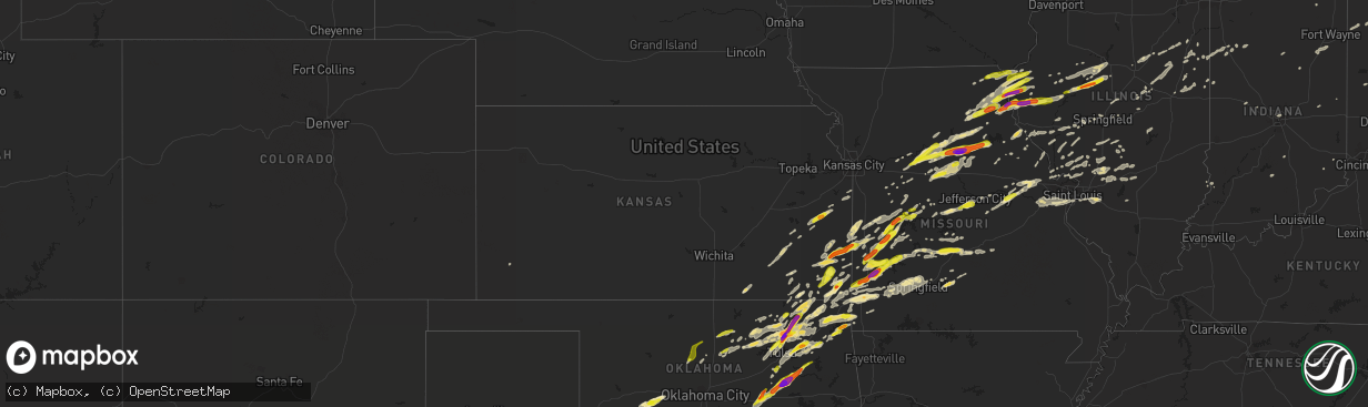
Hail Map in Kansas on May 22, 2019
The weather event in Kansas on May 22, 2019 includes Hail map. 11 states and 712 cities were impacted and suffered possible damage. The total estimated number of properties impacted is 8,709.
Want more than just the map?
Turn this storm into a full workflow.
- Owner + property data so you know who to knock
- OnDemand branded weather history reports to win the "did we even have hail?" argument
- RoofTrace estimate so reps stop guessing numbers at the door
Bought this map? Upgrade within 7 days and we'll credit the $230. (10-15 min setup call)
Hail
8,709
Estimated number of impacted properties by a 1.00" hail or larger1,812
Estimated number of impacted properties by a 1.75" hail or larger0
Estimated number of impacted properties by a 2.50" hail or largerStorm reports in Kansas
Kansas
| Date | Description |
|---|---|
| 05/22/20196:51 PM CDT | A local report indicates 1.75 inch wind near 1 SE SHERWIN |
| 05/22/20196:05 PM CDT | Largest hail the spotter observed but the better core aloft developed just east of this location. |
| 05/22/20193:31 AM CDT | At 831 PM CDT, a severe thunderstorm was located over Frontenac, or over Pittsburg, moving northeast at 45 mph. HAZARD...60 mph wind gusts and half dollar size hail. SOURCE...Radar indicated. IMPACT...Hail damage to vehicles is expected. Expect wind damage to roofs, siding, and trees. Locations impacted include... Pittsburg... Prairie State Park... Frontenac... Girard... Arma... Liberal... Mulberry... Chicopee... Mindenmines... Franklin... Arcadia... Irwin... Burgess... Croweburg... Yale... Iantha... Ringo... Oskaloosa... Verdella... Lone Oak...This includes Interstate 49 between mile markers 70 and 76. |
| 05/22/20193:20 AM CDT | At 819 PM CDT, severe thunderstorms were located along a line extending from near Prescott to near Rich Hill, moving northeast at 45 mph. HAZARD...60 mph wind gusts and half dollar size hail. SOURCE...Radar indicated. IMPACT...Hail damage to vehicles is expected. Expect wind damage to roofs, siding, and trees. Locations impacted include... Butler, Adrian, Rich Hill, Montrose, Hume, Prescott, Amoret, Foster, Passaic, Ballard and Worland. |
| 05/22/20192:24 AM CDT | At 724 PM CDT, a severe thunderstorm was located near Fort Scott, moving east at 35 mph. HAZARD...Two inch hail and 60 mph wind gusts. SOURCE...Radar indicated. IMPACT...People and animals outdoors will be injured. Expect hail damage to roofs, siding, windows, and vehicles. Expect wind damage to roofs, siding, and trees. Locations impacted include... Nevada... Walker... Schell City... Bronaugh... Moundville... Richards... Milo... Deerfield... Metz... Harwood... Stotesbury... Horton...This includes Interstate 49 between mile markers 83 and 107. |
| 05/22/20192:08 AM CDT | At 708 PM CDT, a severe thunderstorm was located near Scammon, or 7 miles northeast of Columbus, moving east at 30 mph. HAZARD...Golf ball size hail and 60 mph wind gusts. SOURCE...Radar indicated. IMPACT...People and animals outdoors will be injured. Expect hail damage to roofs, siding, windows, and vehicles. Expect wind damage to roofs, siding, and trees. Locations impacted include... Prairie State Park... Lamar... Oronogo... Jasper... Golden City... Alba... Purcell... Nashville... Mindenmines... Carytown... Asbury... Neck City... Lamar Heights... Waco... Milford... Oakton... Iantha... Dudenville... Kenoma... Maple Grove...This includes Interstate 49 between mile markers 46 and 71. |
| 05/22/20192:06 AM CDT | At 705 PM CDT, clusters of severe thunderstorms were rapidly developing along and east of an Independence to Erie line. HAZARD...Ping pong ball size hail and 60 mph wind gusts. SOURCE...Radar indicated. IMPACT...People and animals outdoors will be injured. Expect hail damage to roofs, siding, windows, and vehicles. Expect wind damage to roofs, siding, and trees. Locations impacted include... Parsons, Coffeyville, Independence, Cherryvale, Caney, Oswego, Erie, Chetopa, Altamont, St. Paul, Thayer, Edna, Dearing, Mound Valley, Tyro, Galesburg, Liberty, Bartlett, Labette and Stark. |
| 05/22/20192:04 AM CDT | At 704 PM CDT, a severe thunderstorm was located near Mccune, or 10 miles north of Oswego, moving northeast at 30 mph. HAZARD...60 mph wind gusts and half dollar size hail. SOURCE...Radar indicated. IMPACT...Hail damage to vehicles is expected. Expect wind damage to roofs, siding, and trees. Locations impacted include... Pittsburg... Frontenac... Girard... Arma... Cherokee... Weir... Sherman... Mulberry... Scammon... Chicopee... Mccune... Franklin... Arcadia... West Mineral... Roseland... Beulah... Croweburg... Yale... Carona... Brazilton... |
| 05/22/20191:48 AM CDT | At 647 PM CDT, a developing severe thunderstorm was located near Walnut, or 10 miles northeast of St. Paul, moving northeast at 45 mph. This storm is expected to become severe shortly. HAZARD...60 mph wind gusts and quarter size hail. SOURCE...Radar indicated. IMPACT...Hail damage to vehicles is expected. Expect wind damage to roofs, siding, and trees. Locations impacted include... Fort Scott... Marmaton... Arcadia... Uniontown... Walnut... Redfield... Hepler... Pawnee Station... Hiattville... Petersburg... Farlington... Hammond... Garland... Porterville... |
| 05/22/20191:19 AM CDT | At 619 PM CDT, a severe thunderstorm was located near Chetopa, moving northeast at 40 mph. HAZARD...60 mph wind gusts and quarter size hail. SOURCE...Radar indicated. IMPACT...Hail damage to vehicles is expected. Expect wind damage to roofs, siding, and trees. Locations impacted include... Columbus... Cherokee... Weir... Sherman... Scammon... West Mineral... Roseland... Neutral... Melrose... Lawton... Carona... Skidmore... Hallowell... Sherwin... Faulkner... Stippville... Crestline... |
| 05/22/20191:15 AM CDT | At 615 PM CDT, a severe thunderstorm was located near Chetopa, moving northeast at 40 mph. Additional severe thunderstorms to the southwest will likely impact Labette County as well. HAZARD...60 mph wind gusts and quarter size hail. SOURCE...Radar indicated. IMPACT...Hail damage to vehicles is expected. Expect wind damage to roofs, siding, and trees. Locations impacted include... Oswego, Chetopa, Edna, Bartlett and Labette. |
| 05/22/20191:03 AM CDT | At 603 PM CDT, a severe thunderstorm was located near Garnett, moving northeast at 50 mph. HAZARD...60 mph wind gusts and quarter size hail. SOURCE...Radar indicated. IMPACT...Hail damage to vehicles is expected. Expect wind damage to roofs, siding, and trees. Locations impacted include... Paola, Osawatomie, La Cygne, Parker, Fontana and Beagle. |
| 05/22/201912:58 AM CDT | At 558 PM CDT, a severe thunderstorm was located 7 miles southwest of Garnett, moving northeast at 45 mph. HAZARD...60 mph wind gusts and quarter size hail. SOURCE...Radar indicated. IMPACT...Hail damage to vehicles is expected. Expect wind damage to roofs, siding, and trees. This severe thunderstorm will be near... Garnett around 610 PM CDT. Greeley around 620 PM CDT. Lane around 625 PM CDT.Other locations impacted by this severe thunderstorm include GarnettAirport. |
| 05/21/20198:05 PM CDT | Starting point of carl junction tornado. Numerous homes with roof damage and several with damage to the exterior walls...several power poles snapped or leaning...numero |
| 05/21/20197:34 PM CDT | A nws survey confirmed an ef-0 tornado that began in oklahoma before crossing the state line from oklahoma into kansas and then lifting near highway 69 north of treece |
All States Impacted by Hail Map on May 22, 2019
Cities Impacted by Hail Map on May 22, 2019
- McCune, KS
- Topeka, IL
- Easton, IL
- Forest City, IL
- Havana, IL
- Rushville, IL
- Electra, TX
- Shelbyville, MO
- Bethel, MO
- Ramona, OK
- Skiatook, OK
- Seymour, TX
- Iowa Park, TX
- Versailles, IN
- Hermann, MO
- Strafford, MO
- Talala, OK
- Milo, MO
- Osceola, MO
- El Dorado Springs, MO
- Litchfield, IL
- Mount Olive, IL
- Warrensburg, MO
- Camdenton, MO
- Linn Creek, MO
- Collinsville, OK
- Vera, OK
- Harrold, TX
- Saint Patrick, MO
- Carthage, IL
- Alexandria, MO
- Hamilton, IL
- Keokuk, IA
- Lewistown, MO
- Astoria, IL
- Manito, IL
- Green Valley, IL
- New Franklin, MO
- Pilot Grove, MO
- Rocheport, MO
- Boonville, MO
- Harrisburg, MO
- Sedalia, MO
- Clark, MO
- Columbia, MO
- Nelson, MO
- Fayette, MO
- Franklin, MO
- Hallsville, MO
- Blackwater, MO
- Sturgeon, MO
- Centralia, MO
- Bristow, OK
- Beggs, OK
- Escanaba, MI
- Bark River, MI
- Gulliver, MI
- McMillan, MI
- Germfask, MI
- Barnett, MO
- Eldon, MO
- Uniontown, KS
- Madison, MO
- Moberly, MO
- Eucha, OK
- Spavinaw, OK
- Morrisonville, IL
- Springfield, MO
- Greeley, KS
- Welda, KS
- Westphalia, KS
- Lane, KS
- Garnett, KS
- Osawatomie, KS
- Parker, KS
- Neodesha, KS
- Hepler, KS
- Montrose, IA
- Argyle, IA
- Salisbury, MO
- Blackburn, MO
- Santa Fe, MO
- Clifton Hill, MO
- Higbee, MO
- Huntsville, MO
- Glasgow, MO
- Keytesville, MO
- Miami, MO
- Gilliam, MO
- Paris, MO
- Dalton, MO
- Armstrong, MO
- Marshall, MO
- Malta Bend, MO
- Slater, MO
- Fort Scott, KS
- Lebanon, MO
- Niangua, MO
- Grovespring, MO
- South West City, MO
- Anderson, MO
- Wagoner, OK
- La Belle, MO
- Sheldon, MO
- Stockton, MO
- Jerico Springs, MO
- Lockwood, MO
- Lamar, MO
- Anabel, MO
- Ewing, MO
- Clarence, MO
- Leonard, MO
- Deepwater, MO
- Camp Point, IL
- Coatsburg, IL
- Jefferson City, MO
- Russellville, MO
- Eugene, MO
- Yates Center, KS
- Wheatland, MO
- Mount Vernon, MO
- Gilman, IL
- Onarga, IL
- Watseka, IL
- Crescent City, IL
- Bonnots Mill, MO
- Chamois, MO
- Lebanon, IL
- Mascoutah, IL
- New Baden, IL
- Belleville, IL
- Trenton, IL
- Scott Air Force Base, IL
- O'Fallon, IL
- Okemah, OK
- Morrison, MO
- Butler, MO
- Warsaw, IL
- Sutter, IL
- Ursa, IL
- Mendon, IL
- Saint Paul, KS
- Okmulgee, OK
- Morris, OK
- Henley, MO
- Lohman, MO
- Smithboro, IL
- Vandalia, IL
- Mulberry Grove, IL
- Fort Leonard Wood, MO
- Waynesville, MO
- Newburg, MO
- Bartlett, KS
- Edna, KS
- Pawnee, OK
- Catoosa, OK
- Claremore, OK
- Nebo, IL
- Hillview, IL
- Pearl, IL
- Republic, MO
- Bois D Arc, MO
- Ash Grove, MO
- Marionville, MO
- Foristell, MO
- Warrenton, MO
- Truesdale, MO
- Wright City, MO
- Brook, IN
- Kentland, IN
- Goodland, IN
- Sheldon, IL
- New Castle, IN
- New London, MO
- Frankford, MO
- Prescott, KS
- Hume, MO
- Foster, MO
- Rich Hill, MO
- Tulsa, OK
- Broken Arrow, OK
- Pryor, OK
- Inola, OK
- Barnsdall, OK
- Ochelata, OK
- Marthasville, MO
- Versailles, MO
- Middletown, MO
- Eureka, MO
- Oologah, OK
- Norman, IN
- Heltonville, IN
- Ulysses, KS
- Newark, MO
- Dunnegan, MO
- Quincy, IL
- La Grange, MO
- Maywood, MO
- Coffeyville, KS
- Canton, MO
- Basco, IL
- Lookeba, OK
- Adair, IL
- Table Grove, IL
- Timewell, IL
- Highland, IL
- Pocahontas, IL
- Holden, MO
- Centerview, MO
- Redfield, KS
- Erie, KS
- Richards, MO
- Nevada, MO
- Harwood, MO
- Farlington, KS
- Walker, MO
- Galesburg, KS
- Deerfield, MO
- Girard, KS
- Walnut, KS
- Moundville, MO
- Ralston, OK
- Red Rock, OK
- Perry, OK
- Walshville, IL
- Sorento, IL
- Willard, MO
- Fair Grove, MO
- Everton, MO
- Fenton, MO
- High Ridge, MO
- Pekin, IL
- Bath, IL
- Carthage, MO
- Webb City, MO
- Jasper, MO
- Dadeville, MO
- Purcell, MO
- Oronogo, MO
- Galena, KS
- Arcola, MO
- Greenfield, MO
- Carl Junction, MO
- Golden City, MO
- Fair Play, MO
- Neck City, MO
- Alba, MO
- Pittsburg, KS
- Chouteau, OK
- Mount Morris, MI
- Otisville, MI
- West Point, IL
- Elkhart, IL
- Lincoln, IL
- Nowata, OK
- Vinita, OK
- Welch, OK
- Bluejacket, OK
- Frederick, OK
- Loveland, OK
- Davidson, OK
- Seneca, MO
- Joplin, MO
- Neosho, MO
- Sarcoxie, MO
- Diamond, MO
- Chelsea, OK
- Sperry, OK
- Columbus, KS
- Holliday, MO
- Cairo, MO
- Shelbina, MO
- Jacksonville, MO
- Goodman, MO
- Afton, OK
- Wyandotte, OK
- Fairland, OK
- Grove, OK
- Fowler, IL
- Mount Sterling, IL
- Paloma, IL
- Clayton, IL
- Taylor, MO
- Saint Louis, MO
- Bolivar, MO
- Polk, MO
- Stillwater, OK
- Walters, OK
- Monticello, MO
- Canton, IL
- Durham, MO
- Jerseyville, IL
- Portage Des Sioux, MO
- La Monte, MO
- Knob Noster, MO
- Houstonia, MO
- Adair, OK
- Strang, OK
- Peoria, IL
- East Peoria, IL
- Creve Coeur, IL
- Kingston Mines, IL
- Glasford, IL
- Mapleton, IL
- Bartlesville, OK
- Seminole, OK
- Wewoka, OK
- Porter, OK
- Redbird, OK
- Boley, OK
- Haskell, OK
- Castle, OK
- Coweta, OK
- Monon, IN
- Rensselaer, IN
- Hartville, MO
- Wichita Falls, TX
- Randlett, OK
- Burkburnett, TX
- Devol, OK
- Rapid River, MI
- Martinsburg, MO
- Benton City, MO
- Bucyrus, KS
- Louisburg, KS
- Jay, OK
- Bethany, IL
- Sullivan, IL
- Findlay, IL
- Rhineland, MO
- Mulhall, OK
- Fairfax, OK
- Richland, MO
- Stoutland, MO
- Tunas, MO
- Windyville, MO
- Buffalo, MO
- Eldridge, MO
- Sand Springs, OK
- Carlock, IL
- Paola, KS
- Antwerp, OH
- Cecil, OH
- Paulding, OH
- Louisiana, MO
- Bowling Green, MO
- Hennessey, OK
- Dover, OK
- Lowry City, MO
- Appleton City, MO
- Clinton, MO
- Schell City, MO
- Rockville, MO
- Laquey, MO
- Bunker Hill, IL
- Piasa, IL
- Shipman, IL
- Brighton, IL
- Lawton, OK
- Gladstone, MI
- Delavan, IL
- Tremont, IL
- Lewistown, IL
- Hydro, OK
- Luray, MO
- Manistique, MI
- New Berlin, IL
- Thawville, IL
- Buckley, IL
- Montrose, MO
- Wynona, OK
- Marshfield, MO
- Rockport, IL
- Barry, IL
- New Canton, IL
- Fulton, KS
- Coleman, WI
- Centralia, IL
- Stover, MO
- Half Way, MO
- Collins, MO
- Concordia, MO
- Knox City, MO
- Seymour, MO
- Mansfield, MO
- Dexter, KS
- Milan, IN
- Parsons, KS
- Oswego, KS
- Preston, MO
- Hollister, OK
- Quapaw, OK
- Granby, MO
- Wentworth, MO
- Pierce City, MO
- Colony, OK
- Champaign, IL
- Cullom, IL
- Macks Creek, MO
- Lawrenceville, IL
- Monticello, IN
- Weir, KS
- Cherokee, KS
- Scammon, KS
- Chetopa, KS
- Rossville, IL
- Laddonia, MO
- Rush Hill, MO
- Macomb, IL
- Holts Summit, MO
- Tebbetts, MO
- Carnegie, OK
- Cordell, OK
- Hinton, OK
- Cole Camp, MO
- Warsaw, MO
- Carterville, MO
- La Russell, MO
- Long Lane, MO
- Reeds, MO
- Lincoln, MO
- Louisburg, MO
- Stotts City, MO
- Flemington, MO
- Urbana, MO
- Winchester, IN
- Mendon, MO
- Bellflower, IL
- Sibley, IL
- Melvin, IL
- Gibson City, IL
- Chatsworth, IL
- Strawn, IL
- Le Roy, IL
- Saybrook, IL
- Arrowsmith, IL
- Atlanta, MO
- Nauvoo, IL
- Arbela, MO
- Wyaconda, MO
- Wayland, MO
- Kahoka, MO
- Windsor, MO
- Calhoun, MO
- Neosho Falls, KS
- Staunton, IL
- Worden, IL
- New Douglas, IL
- Cuba, IL
- Groveland, IL
- Bryant, IL
- Smithfield, IL
- Saint David, IL
- Ipava, IL
- Baxter Springs, KS
- Hobart, OK
- Gotebo, OK
- Jonesburg, MO
- Toronto, KS
- Howard, KS
- Fall River, KS
- Clinton, IL
- Farmer City, IL
- Mechanicsburg, OH
- Stark City, MO
- Stella, MO
- Meredosia, IL
- Bluffs, IL
- Farmersville, IL
- Waggoner, IL
- Girard, IL
- Greenville, IL
- Winfield, MO
- Batchtown, IL
- Brussels, IL
- Glencoe, OK
- Salina, OK
- Liberal, MO
- Kiefer, OK
- Glenpool, OK
- Mounds, OK
- Hominy, OK
- Liberty, KS
- Rankin, IL
- Crawfordsville, IN
- Oaktown, IN
- Bruceville, IN
- Browning, IL
- Philadelphia, MO
- Palmyra, MO
- Williamsport, IN
- Oakwood, OH
- Defiance, OH
- Pawhuska, OK
- Maramec, OK
- Osage, OK
- Cleveland, OK
- Moran, KS
- Elsmore, KS
- Savonburg, KS
- Bronson, KS
- Marion, IN
- Labadie, MO
- Olean, MO
- Gravois Mills, MO
- Milford, IL
- Caney, KS
- Independence, KS
- Perry, MO
- Freeburg, MO
- Lenapah, OK
- Palmer, IL
- Gridley, IL
- Montreal, MO
- S Coffeyville, OK
- Dallas City, IL
- Tiff City, MO
- Big Cabin, OK
- Pittsfield, IL
- Farber, MO
- Delaware, OK
- Shobonier, IL
- Fredonia, KS
- Elk City, KS
- Nokomis, IL
- Mountain Grove, MO
- Chebanse, IL
- Clifton, IL
- Fillmore, IL
- Pleasant Plains, IL
- Springfield, IL
- East Carondelet, IL
- Washington, MO
- Valley Park, MO
- Wildwood, MO
- Defiance, MO
- Pacific, MO
- Augusta, MO
- Saint Albans, MO
- Ballwin, MO
- Villa Ridge, MO
- Dupo, IL
- Gray Summit, MO
- Kempton, IL
- Carlinville, IL
- Chesterfield, IL
- Medora, IL
- Fidelity, IL
- Prue, OK
- Owasso, OK
- Mannford, OK
- Pontiac, IL
- Ludlow, IL
- Cissna Park, IL
- Elsberry, MO
- Annada, MO
- Golden Eagle, IL
- O'Fallon, MO
- Eldred, IL
- White Hall, IL
- Carrollton, IL
- Berger, MO
- Mount Sterling, MO
- Danville, IL
- Alvin, IL
- Chilhowee, MO
- Altamont, KS
- Jenks, OK
- Sapulpa, OK
- Markle, IN
- Uniondale, IN
- Fort Loramie, OH
- Yorkshire, OH
- Versailles, OH
- Rockbridge, IL
- Kane, IL
- Ionia, MO
- Indianapolis, IN
- Buffalo, IL
- Gillespie, IL
- Emden, MO
- Ramsey, IL
- Godfrey, IL
- Alton, IL
- Bethalto, IL
- Paxton, IL
- Winchester, IL
- Jacksonville, IL
- Bronaugh, MO
- Murrayville, IL
- Alexander, IL
- Wann, OK
- Fort Sill, OK
- Thomasboro, IL
- Penfield, IL
- Armstrong, IL
- Ogden, IL
- Urbana, IL
- Saint Joseph, IL
- Potomac, IL
- Gifford, IL
- Remington, IN
- Smithton, MO
- Mora, MO
- Forsyth, IL
- Decatur, IL
- Oreana, IL
- West Alton, MO
- Saint Charles, MO
- Arma, KS
- Mindenmines, MO
- Franklin, KS
- Mulberry, KS
- Millstadt, IL
- Carrollton, MO
- Norborne, MO
- Columbiaville, MI
- Otter Lake, MI
- Dewitt, IL
- Stark, KS
- Peru, IN
- Fieldon, IL
- Linn, MO
- Wentzville, MO
- Bland, MO
- Rutledge, MO
- Gorin, MO
- Donnellson, IL
- Bingham, IL
- Coffeen, IL
- West Mineral, KS
- Dow, IL
- Columbus, IN
- Quincy, MO
- Mound Valley, KS
- Cherryvale, KS
- Lone Wolf, OK
- Wolcott, IN
- Golden, IL
- Bowen, IL
- Edgar Springs, MO
- Rolla, MO
- Grafton, IL
- Hillsboro, IL
- Panama, IL
- Alhambra, IL
- Palmyra, IL
- Greenfield, IL
- Roodhouse, IL
- Crescent, OK
- Dawson, IL
- Maud, OK
- Huntington, IN
- Warren, IN
- Ossian, IN
- Farmington, IL
- Memphis, MO
- Miami, OK
- Troy, MO
- Sentinel, OK
- Rocky, OK
- Jamestown, IN
- Waverly, MO
- Corder, MO
- Fairview, IL
- Arcadia, KS
- Treece, KS
- Riverton, KS
- Copan, OK
- Morrison, OK
- Elberton, GA
- Colony, KS
- Martinton, IL
- Rome City, IN
- Wolcottville, IN
- Lexington, IL
- Chenoa, IL
- Hudson, IL
- Forrest, IL
- Fairbury, IL
- Binger, OK
- Industry, IL
- Higginsville, MO
- Plymouth, IL
- Williamstown, MO
- Novelty, MO
- Macon, MO
- Loraine, IL
- Kinderhook, IL
- Witt, IL
- Vandalia, MO
- Brookline, MO
- Halltown, MO
- Pleasant Hope, MO
- Miller, MO
- Monett, MO
- Aurora, MO
- Billings, MO
- Alma, MO
- Covington, OK
- Fairmont, OK
- Waukomis, OK
- Marshall, OK
- Douglas, OK
- Bison, OK
- Chattanooga, OK
- Marland, OK
- Camden, IL
- Huntsville, IL
- Asbury, MO
- Revere, MO
- Wells, MI


