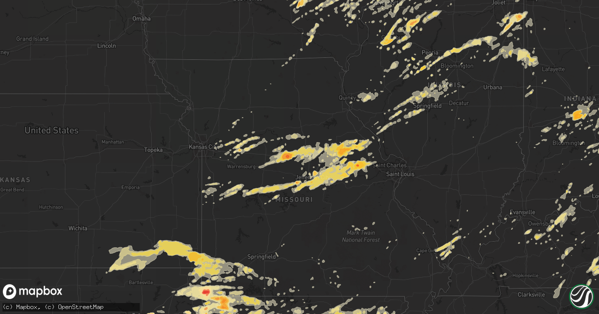
Hail Map in Wisconsin on May 22, 2011
Get this storm
May 22 map
$229
one time, instant access
Download today. No call, no setup
Keep the $229
Bought the map and want the full workflow? Apply the entire $229 to a subscription within 7 days. None of it is wasted.
Every map, not just this one
This buys you this map. Subscription and you get every map we run, in the markets you choose from a few cities to whole states to nationwide. Plus real-time alerts the moment a storm fires.
Contact data
Name, contact info, occupancy, even credit band for addresses in the footprint. You go from where it hit to who to call.
Become the source they trust
Unlimited branding weather history reports on demand. You already have the documented answer ready for the property owner, and you are the one who showed up with it.
Property data and RoofTrace estimates
Pull up any address you have got, its value and the exact code rules for that jurisdiction, straight from One Click Code. Then RoofTrace estimates the squares, pitch, and roof value, priced the way you price.
Storm reports in Wisconsin
Wisconsin
| Date | Description |
|---|---|
| 05/22/20116:39 PM CDT | A local report indicates 60 MPH wind near RANDOM LAKE |
| 05/22/20116:38 PM CDT | Tornado on the ground |
| 05/22/20116:36 PM CDT | Covering the ground. |
| 05/22/20116:35 PM CDT | A local report indicates 1.50 inch wind near ARNOTT |
| 05/22/20116:35 PM CDT | A local report indicates 1.25 inch wind near PLOVER |
| 05/22/20116:30 PM CDT | Delayed report. Smoking power pole |
| 05/22/20116:30 PM CDT | Barn and silo destroyed near 1049 county west rd. Barn destroyed near 6487 eckels rd. Barn destroyed near 169 steward rd and county rd bb. |
| 05/22/20116:30 PM CDT | A local report indicates 1.75 inch wind near KELLNER |
| 05/22/20116:30 PM CDT | Hwy 54 and i-39. Tornado on the ground. |
| 05/22/20116:29 PM CDT | Several reports of major damage. Tornado went through grand rapids. Location estimated. |
| 05/22/20116:27 PM CDT | At the sullivan nws office...3 miles southeast of the village of sullivan. |
| 05/22/20116:26 PM CDT | Brief tornado. Rated ef-0. |
| 05/22/20116:23 PM CDT | A local report indicates 1.75 inch wind near WISCONSIN RAPIDS |
| 05/22/20116:19 PM CDT | Hail ranging from half to one inch. Lasted about 3 minutes. |
| 05/22/20116:18 PM CDT | A local report indicates 1.75 inch wind near PALMYRA |
| 05/22/20116:16 PM CDT | 3 to 4 houses damaged in the saratoga township. 1 garage destroyed near hwy 73 and county road evergreen. 3 minor injuries in saratoga. Several large power poles down n |
| 05/22/20116:16 PM CDT | Structure damage and a barn missing. |
| 05/22/20116:14 PM CDT | A local report indicates 1.00 inch wind near 2 S WISCONSIN RAPIDS |
| 05/22/20116:13 PM CDT | Several large trees blown down. |
| 05/22/20116:13 PM CDT | Spotter estimates 55 to 60 mph wind gust |
| 05/22/20116:13 PM CDT | Shed destroyed near county road h and willow road reported by law enforcement. Location is estimated...damage could be from a possible tornado. |
| 05/22/20116:13 PM CDT | Shed destroyed near county road h and willow road reported by law enforcement. Location is estimated...damage could be from a possible tornado. |
| 05/22/20116:13 PM CDT | Tornado on the ground |
| 05/22/20116:13 PM CDT | Tornado on the ground just northeast of phillips |
| 05/22/20116:10 PM CDT | Estimated 55 to 60 mph gusts |
| 05/22/20116:08 PM CDT | Delayed report. Trees and wires down. |
| 05/22/20116:08 PM CDT | A local report indicates 1.00 inch wind near NEKOOSA |
| 05/22/20116:07 PM CDT | A local report indicates 1.00 inch wind near 5 SSE WHITEWATER |
| 05/22/20116:06 PM CDT | On hwy 80 |
| 05/22/20116:05 PM CDT | Trees down...power outages...and damage to a fence in the hustisford area...at intersection of highway e and highway 60. |
| 05/22/20116:01 PM CDT | 1.9 mile path length. Max path width 0.21 miles. Rated ef-0. |
| 05/22/20116:01 PM CDT | A local report indicates 1.00 inch wind near 2 N RICHLAND CENTER |
| 05/22/20116:01 PM CDT | Corrected from earlier report...spotter measured a stone to confirm size. |
| 05/22/20115:59 PM CDT | Delayed report. Tree down. |
| 05/22/20115:57 PM CDT | On county road zz. |
| 05/22/20115:56 PM CDT | A high power transmission line collapsed near county road f and 13th ave along the finley and armenia township lines. |
| 05/22/20115:56 PM CDT | At highway zz and 14. |
| 05/22/20115:56 PM CDT | On the north side of watertown. |
| 05/22/20115:55 PM CDT | A local report indicates 1.00 inch wind near BABCOCK |
| 05/22/20115:55 PM CDT | A local report indicates 58 MPH wind near FORT ATKINSON |
| 05/22/20115:52 PM CDT | Brief spin up. Rated ef-0. |
| 05/22/20115:51 PM CDT | Marble to quarter size hail |
| 05/22/20115:39 PM CDT | 1 mile path. 0.22 miles wide. Rated ef-0. |
| 05/22/20115:39 PM CDT | A local report indicates 1.00 inch wind near DYCKESVILLE |
| 05/22/20115:36 PM CDT | A local report indicates 1.00 inch wind near 1 N CLYMAN |
| 05/22/20115:34 PM CDT | A local report indicates 1.00 inch wind near LAKE MILLS |
| 05/22/20115:33 PM CDT | A local report indicates 1.50 inch wind near 2 S KENNAN |
| 05/22/20115:32 PM CDT | Large tree branches blown down. |
| 05/22/20115:29 PM CDT | Outbuildings destroyed at farmstead. |
| 05/22/20115:29 PM CDT | A local report indicates 1.00 inch wind near WRIGHTSTOWN |
| 05/22/20115:24 PM CDT | Roff damage...debris...and tree damage on egress ave n of county e. |
| 05/22/20115:21 PM CDT | A local report indicates 1.75 inch wind near KAUKAUNA |
| 05/22/20115:20 PM CDT | A local report indicates 1.50 inch wind near 8 SE APPLETON |
| 05/22/20115:18 PM CDT | At the intersection of mason and packerland. Power pole down. |
| 05/22/20115:18 PM CDT | A local report indicates 1.50 inch wind near 5 WSW WARRENS |
| 05/22/20115:15 PM CDT | A local report indicates 1.00 inch wind near DARBOY |
| 05/22/20115:15 PM CDT | A local report indicates 1.00 inch wind near 2 NW DARBOY |
| 05/22/20115:15 PM CDT | Damage survey was done 5/23. Tornado formed 4 miles northwest of tomah near county road m. The maximum damage was ef2 in several locations along its path. At its widest |
| 05/22/20115:14 PM CDT | Large trees blown down. |
| 05/22/20115:12 PM CDT | Dime to quarter |
| 05/22/20115:11 PM CDT | Lawerence campus. |
| 05/22/20115:10 PM CDT | A local report indicates 1.50 inch wind near HOWARD |
| 05/22/20115:06 PM CDT | At fox valley tech college |
| 05/22/20115:05 PM CDT | Delayed report |
| 05/22/20115:05 PM CDT | A local report indicates 60 MPH wind near GREEN BAY |
| 05/22/20115:03 PM CDT | At the nwtc campus |
| 05/22/20115:00 PM CDT | Damage to buildings on south side of sparta |
| 05/22/20115:00 PM CDT | Reported by fire department |
| 05/22/20114:59 PM CDT | A local report indicates 1.00 inch wind near BARRE MILLS |
| 05/22/20114:58 PM CDT | A local report indicates 1.00 inch wind near OSHKOSH |
| 05/22/20114:58 PM CDT | Measured 1.7 inch |
| 05/22/20114:58 PM CDT | A local report indicates 60 MPH wind near 1 S SPARTA |
| 05/22/20114:56 PM CDT | Cars flipped...turned...debris impact has destroyed numerous windows at brennegen chev dealer. |
| 05/22/20114:56 PM CDT | At i90 exit 25 |
| 05/22/20114:56 PM CDT | Preliminary damage assessment by nws. Low end ef1 tornado on south side of sparta. 70 yards wide but not a continuous path toward warrens. Time estimated by spotter rep |
| 05/22/20114:55 PM CDT | Some trees snapped off and billboards down. |
| 05/22/20114:55 PM CDT | A local report indicates 1.25 inch wind near SUN PRAIRIE |
| 05/22/20114:55 PM CDT | Tornado formed at 455 pm and tracked 2 miles with a maximum width of 70 yards and ef1 damage. The tornado dissipated at 500 pm 2 miles southeast of sparta. |
| 05/22/20114:52 PM CDT | A local report indicates 1.00 inch wind near 1 N SUN PRAIRIE |
| 05/22/20114:49 PM CDT | Delayed report |
| 05/22/20114:47 PM CDT | Power pole and tree limbs down along babit avenue on the north side of gilman. Time radar estimated. |
| 05/22/20114:45 PM CDT | A local report indicates 1.00 inch wind near BLACK CREEK |
| 05/22/20114:40 PM CDT | Some small trees and tree branches blown down east on highway 70 towards couderay. |
| 05/22/20114:37 PM CDT | A few trees blown down along county road ii |
| 05/22/20114:35 PM CDT | Some tops of trees were broken off along county road m. |
| 05/22/20114:33 PM CDT | A local report indicates 1.75 inch wind near 1 E NEW LONDON |
| 05/22/20114:30 PM CDT | A local report indicates 1.75 inch wind near 2 SE NEW LONDON |
| 05/22/20114:27 PM CDT | Some small trees and tree branches down near hwy 70/27 intersection. |
| 05/22/20114:26 PM CDT | Measured near 16th street and denton in la crosse as tornado passed by. Anemometer is at 35 feet. |
| 05/22/20114:26 PM CDT | A local report indicates 1.25 inch wind near DALE |
| 05/22/20114:25 PM CDT | Tree down near 19th and denton |
| 05/22/20114:23 PM CDT | Damage survey conducted 5/23. Tornado moved off the mississippi river at 423 pm near green island park causing lower end ef-2 damage. The path continued east-northeast |
| 05/22/20114:18 PM CDT | Several trees down |
| 05/22/20114:12 PM CDT | A local report indicates 1.50 inch wind near 1 W GREENVILLE |
| 05/22/20114:07 PM CDT | A local report indicates 1.00 inch wind near 2 S CHIPPEWA FALLS |
| 05/22/20114:07 PM CDT | A local report indicates 1.25 inch wind near 1 N DALE |
| 05/22/20114:07 PM CDT | A local report indicates 1.50 inch wind near 2 NW LARSEN |
| 05/22/20114:06 PM CDT | A local report indicates 1.00 inch wind near SCANDINAVIA |
| 05/22/20114:06 PM CDT | A local report indicates 1.00 inch wind near LAKE POYGAN |
| 05/22/20114:05 PM CDT | Hwy 10 and 45 |
| 05/22/20114:01 PM CDT | On hwy 10. |
| 05/22/20114:00 PM CDT | Possible torndao. 2 homes sustained roof damage with numerous trees down between mikana and brill. |
| 05/22/20113:57 PM CDT | Sporadic tree damage from near and east of butternut to the northeast into the area just northwest of the turtle flambeau flowage. Also a large volume of hail fell in b |
| 05/22/20113:50 PM CDT | A local report indicates 1.00 inch wind near AMHERST |
| 05/22/20113:47 PM CDT | A local report indicates 1.50 inch wind near BORTH |
| 05/22/20113:45 PM CDT | A local report indicates 2.00 inch wind near 2 SW POY SIPPI |
| 05/22/20113:41 PM CDT | Small branches down. Penny size hail. |
| 05/22/20113:35 PM CDT | Covering ground. |
| 05/22/20113:23 PM CDT | A local report indicates 1.00 inch wind near 6 SW BUTTERNUT |
| 05/22/20113:22 PM CDT | Reported along murphy rd...neshkoro. Time estimated from radar...delayed report. |
| 05/22/20113:20 PM CDT | A local report indicates 1.75 inch wind near 5 W NESHKORO |
| 05/22/20113:20 PM CDT | North side of crystal lake |
| 05/22/20113:20 PM CDT | A local report indicates 1.00 inch wind near 4 SSW WAUTOMA |
| 05/22/20113:15 PM CDT | Report of damage to barns and outbuildings. Also a 6 mile stretch of downed trees from the southwest to northeast...a mile or two south and east of butternut. Damage ti |
| 05/22/20113:15 PM CDT | Had ping pong to golf ball size hail in elmwood. Also had gusty winds...but no reports of wind damage. |
| 05/22/20113:14 PM CDT | A local report indicates 1.50 inch wind near 3 W ELMWOOD |
| 05/22/20113:14 PM CDT | 80 ft silo knocked down. Barn and pole building destroyed. Delayed report. Time estimated by radar. |
| 05/22/20113:12 PM CDT | A local report indicates 1.00 inch wind near 4 NW ELMWOOD |
| 05/22/20113:10 PM CDT | A local report indicates 2.75 inch wind near 1 S WESTFIELD |
| 05/22/20113:07 PM CDT | Minor damage to siding on a home and barn severly damaged. |
| 05/22/20113:05 PM CDT | A local report indicates 4.25 inch wind near 1 E WESTFIELD |
| 05/22/20113:04 PM CDT | Cracked windshields of autos |
| 05/22/20113:04 PM CDT | 12-14 inch diameter trees down across kley rd |
| 05/22/20113:04 PM CDT | A local report indicates 1.00 inch wind near 3 N BUTTERNUT |
| 05/22/20113:01 PM CDT | A local report indicates 2.00 inch wind near WESTFIELD |
| 05/22/20113:00 PM CDT | A local report indicates 2.00 inch wind near WESTFIELD |
| 05/22/20112:52 PM CDT | A local report indicates 1.00 inch wind near BIG FLATS |
| 05/22/20112:44 PM CDT | A local report indicates 2.75 inch wind near MAUSTON |
| 05/22/20112:39 PM CDT | Numerous large trees blown down and snapped. |
| 05/22/20112:38 PM CDT | Trees reported down along price lakes rd south of hwy 70. Likely associated with the first storm that moved through the area. |
| 05/22/20112:35 PM CDT | Hail accumulated to a depth of 6 inches along the sides of the roads. |
| 05/22/20112:35 PM CDT | Trees down along county highway w near price and sawyer county border. Time is estimated from radar. |
| 05/22/20112:33 PM CDT | 2.8 mile path length to the nne from starting point. Mainly tree damage. Rated low-end ef-1. |
| 05/22/20112:30 PM CDT | A local report indicates 1.25 inch wind near 5 N MAUSTON |
| 05/22/20112:30 PM CDT | A local report indicates 1.00 inch wind near MARSHFIELD |
| 05/22/20112:28 PM CDT | Numerous large trees blown over and snapped. |
| 05/22/20112:26 PM CDT | Numerous large trees blown down and snapped. |
| 05/22/20112:25 PM CDT | At flambeau river state park headquarters. Some sporadic tree damage with a few limbs broken off or trees snapped across parts of the state forest. |
| 05/21/20118:07 PM CDT | 53 knot wind gust at airport. |
| 05/21/20118:02 PM CDT | Roofing torn off days inn at 13th and college. Estimated 60 mph winds. |
| 05/21/20117:54 PM CDT | A local report indicates 60 MPH wind near UNION GROVE |
| 05/21/20117:52 PM CDT | Pea size hail also falling. |
| 05/21/20117:50 PM CDT | Efo tornado started 0.3 miles nw of markesan and ended 4.5 miles nne of markesan. Path width 50 yds...path length 4.7 miles. Tornado began at 750 pm and ended at 757 pm |
| 05/21/20117:50 PM CDT | Roof torn off a home |
| 05/21/20117:50 PM CDT | Trees and power lines downed by thunderstorm. Emergency manager to investigate further. |
| 05/21/20117:49 PM CDT | Trees down in the town of brighton. |
| 05/21/20117:48 PM CDT | Trees down in the town of salem. |
| 05/21/20117:47 PM CDT | Efo tornado started 0.3 miles nw of markesan and ended 4.5 miles nne of markesan. Path width 50 yds...path length 4.7 miles. Tornado began at 747 pm and ended at 755 pm |
| 05/21/20117:45 PM CDT | Ef0 tornado spun up at an estimated time of 745 pm and lasted less than 1 minute. Estimated winds of 70 mph. There was damage to large tree branches...a shed door at a |
| 05/21/20117:33 PM CDT | Ef0 tornado spun up at an estimated time of 733 pm and lasted less than 1 minute. Estimated winds of 70 mph. There was damage to large tree branches...a shed door at a |
| 05/21/20117:11 PM CDT | A local report indicates 1.00 inch wind near 4 S SCANDINAVIA |
| 05/21/20117:06 PM CDT | Tree down blocking road. Delayed report...time of damage estimated from doppler radar imagery. |
| 05/21/20117:05 PM CDT | A local report indicates 60 MPH wind near 1 W BELOIT |
All States Impacted by Hail Map on May 22, 2011
Cities Impacted by Hail Map on May 22, 2011
- Chico, TX
- Newcastle, TX
- Bryson, TX
- Loving, TX
- Alvord, TX
- Bridgeport, TX
- Olney, TX
- Jermyn, TX
- Graham, TX
- Bowie, TX
- Jacksboro, TX
- Berryville, AR
- Omaha, AR
- Green Forest, AR
- Eureka Springs, AR
- Leaf River, IL
- Savanna, IL
- Hazen, AR
- Cincinnati, OH
- Cleves, OH
- North Bend, OH
- Addyston, OH
- Clinton, TN
- May, TX
- Sidney, TX
- Rison, AR
- Pine Bluff, AR
- Elgin, IA
- Luana, IA
- Fayette, IA
- West Union, IA
- Saint Olaf, IA
- Postville, IA
- Elkader, IA
- Wadena, IA
- Davis, IL
- Durand, IL
- Brodhead, WI
- Dakota, IL
- Freeport, IL
- Rock City, IL
- Tulsa, OK
- Pleasant View, TN
- Joelton, TN
- Ashland City, TN
- Keota, IA
- Bradford, AR
- Henrietta, TX
- Scotland, TX
- Windthorst, TX
- Merkel, TX
- Wetumka, OK
- Holdenville, OK
- Trivoli, IL
- Cannon Falls, MN
- Dennison, MN
- Kenyon, MN
- Weleetka, OK
- German Valley, IL
- Monroe Center, IL
- Cherry Valley, IL
- Pecatonica, IL
- Kirkland, IL
- Mount Morris, IL
- Forreston, IL
- Rockford, IL
- Baileyville, IL
- Ridott, IL
- Oregon, IL
- Byron, IL
- Winnebago, IL
- Polo, IL
- Davis Junction, IL
- Stillman Valley, IL
- Loves Park, IL
- Lindenwood, IL
- Belvidere, IL
- Machesney Park, IL
- Rochelle, IL
- Dixon, IL
- Williamsburg, MI
- Elk Rapids, MI
- Jonesboro, AR
- Flippin, AR
- Mountain Home, AR
- Gassville, AR
- Canton, IL
- Manito, IL
- Liverpool, IL
- Topeka, IL
- Stockton, IA
- Durant, IA
- Muscatine, IA
- Blue Grass, IA
- Chilton, WI
- Glasford, IL
- Lone Tree, IA
- Riverside, IA
- Coahoma, TX
- Germantown, WI
- Preston, IA
- Mars Hill, NC
- Berlin, WI
- Pine River, WI
- Redgranite, WI
- Lone Grove, OK
- Ardmore, OK
- Wilson, OK
- Springer, OK
- Baldwin, WI
- Spring Valley, WI
- Woodville, WI
- Bismarck, AR
- Arkadelphia, AR
- Empire, MI
- Fort Stockton, TX
- Fort Worth, TX
- North Little Rock, AR
- Jacksonville, AR
- Little Rock, AR
- Hensley, AR
- Benton, AR
- Bauxite, AR
- Hot Springs Village, AR
- Traskwood, AR
- Malvern, AR
- Sheridan, AR
- Alexander, AR
- Mabelvale, AR
- Lonsdale, AR
- Scott, AR
- Bryant, AR
- Lonoke, AR
- West Liberty, IA
- Clinton, MO
- Montrose, MO
- Baird, TX
- Wanamingo, MN
- Zumbrota, MN
- West Concord, MN
- Hulbert, OK
- Locust Grove, OK
- Peggs, OK
- Louisburg, KS
- Paola, KS
- La Cygne, KS
- Fontana, KS
- Garden Prairie, IL
- Montezuma, IA
- Chouteau, OK
- Wagoner, OK
- Inola, OK
- Tiffin, IA
- Solon, IA
- Wyoming, IA
- Oxford, IA
- Ely, IA
- Olin, IA
- North Liberty, IA
- Stanwood, IA
- Anamosa, IA
- Lisbon, IA
- Mechanicsville, IA
- Mount Vernon, IA
- Prairie Grove, AR
- Hawesville, KY
- Rome, IN
- Cloverport, KY
- Cannelton, IN
- Westfield, WI
- Athens, IL
- Gallatin, TN
- Bethpage, TN
- Belvidere, TN
- Winchester, TN
- Pulaski, WI
- Waukesha, WI
- Brookfield, WI
- Warrenton, MO
- Truesdale, MO
- Peebles, OH
- West Union, OH
- Coralville, IA
- Iowa City, IA
- Caledonia, MN
- Tanner, AL
- Siler, KY
- Williamsburg, KY
- Augusta, IL
- Montello, WI
- Deer Grove, IL
- Cedar Rapids, IA
- Hiawatha, IA
- Camp Point, IL
- Timewell, IL
- Clayton, IL
- Liberty, IL
- Colfax, IL
- Huntland, TN
- Millersburg, MI
- Onaway, MI
- Parker, KS
- Winfield, IA
- Goose Lake, IA
- Clinton, IA
- De Witt, IA
- New London, WI
- Winchester, IL
- Paragould, AR
- Beech Grove, AR
- Wyandotte, OK
- Fairland, OK
- Henryetta, OK
- Dustin, OK
- Okemah, OK
- Wewoka, OK
- Belgium, WI
- Cedar Grove, WI
- Lafe, AR
- Marmaduke, AR
- Roanoke, VA
- Boones Mill, VA
- Paron, AR
- Chuckey, TN
- Smithshire, IL
- Colt, AR
- Freeburg, MO
- Linn, MO
- New Richmond, IN
- Krakow, WI
- Oconto Falls, WI
- Deerfield, VA
- Scandinavia, WI
- Amherst Junction, WI
- Decatur, AR
- Gravette, AR
- Grafton, WI
- Mequon, WI
- Watertown, WI
- Elkhorn, WI
- Whitewater, WI
- Shirley, AR
- Fittstown, OK
- Allen, OK
- Roff, OK
- Ada, OK
- Fitzhugh, OK
- Stonewall, OK
- Cherryvale, KS
- Midkiff, TX
- Hennepin, OK
- Ratliff City, OK
- Wynnewood, OK
- Sasakwa, OK
- Sulphur, OK
- Atwood, OK
- Dougherty, OK
- Davis, OK
- Stratford, OK
- Healdton, OK
- Mill Creek, OK
- Graham, OK
- Overbrook, OK
- Little York, IL
- Butler, MO
- Lost Nation, IA
- Calamus, IA
- Wilton, IA
- Bennett, IA
- Delmar, IA
- Wheatland, IA
- Grand Mound, IA
- Dixon, IA
- New Liberty, IA
- Welton, IA
- Charlotte, IA
- Mabel, MN
- Canton, MN
- Iron River, MI
- Huntsville, AR
- Compton, AR
- Alpena, AR
- Harrison, AR
- Searsboro, IA
- Grinnell, IA
- Silex, MO
- Pulaski, IL
- Ullin, IL
- Cedar Vale, KS
- Sedan, KS
- Pawhuska, OK
- Peru, KS
- Havana, KS
- Niotaze, KS
- Catoosa, OK
- Broken Arrow, OK
- Seaman, OH
- Winchester, OH
- Hillsboro, OH
- Witts Springs, AR
- Marshall, AR
- Manawa, WI
- Bear Creek, WI
- Clintonville, WI
- Carver, MN
- Shakopee, MN
- Jordan, MN
- Belle Plaine, MN
- Mancelona, MI
- East Jordan, MI
- New Hampton, IA
- Fredericksburg, IA
- Bethany, IL
- Rumsey, KY
- Calhoun, KY
- Bellflower, MO
- Middletown, MO
- Marshall, WI
- Columbus, WI
- Goshen, VA
- Rose, OK
- Kansas, OK
- Twin Oaks, OK
- Buckley, MI
- Kingsley, MI
- Mesick, MI
- Park Falls, WI
- Winter, WI
- Butternut, WI
- Oak Ridge, TN
- Knoxville, TN
- Blanchester, OH
- Holmen, WI
- West Salem, WI
- Mindoro, WI
- Gilliam, MO
- Glasgow, MO
- Thayer, KS
- Ryan, OK
- Martha, KY
- Blaine, KY
- Flatgap, KY
- Keaton, KY
- Warsaw, MO
- Oktaha, OK
- Liberty, TN
- Woodbury, TN
- Billings, MO
- Mount Vernon, MO
- Crane, MO
- Verona, MO
- Aurora, MO
- Marionville, MO
- Red Wing, MN
- Spring Grove, MN
- Houston, MN
- Rushford, MN
- Hortonville, WI
- Greenville, WI
- Larsen, WI
- Fremont, WI
- West Branch, IA
- Kalona, IA
- Manchester, KY
- Columbus Junction, IA
- Lowmansville, KY
- Louisa, KY
- Paintsville, KY
- Ulysses, KY
- River, KY
- Kimberly, WI
- Kaukauna, WI
- Seymour, WI
- Oneida, WI
- Luxemburg, WI
- Brillion, WI
- Green Bay, WI
- Wrightstown, WI
- Omro, WI
- Appleton, WI
- Neenah, WI
- Poy Sippi, WI
- Greenleaf, WI
- Wautoma, WI
- Winneconne, WI
- Combined Locks, WI
- New Franken, WI
- Shiocton, WI
- Black Creek, WI
- Wild Rose, WI
- Little Chute, WI
- Sherwood, WI
- De Pere, WI
- Suamico, WI
- Menasha, WI
- Neshkoro, WI
- Oshkosh, WI
- Neponset, IL
- Peterson, MN
- Wakefield, MI
- Piketon, OH
- Latham, OH
- Lincoln, MO
- Riceville, TN
- Athens, TN
- Calhoun, TN
- Brownsville, MN
- Hokah, MN
- Nekoosa, WI
- Wisconsin Rapids, WI
- Luzerne, MI
- Rose City, MI
- Mio, MI
- Wonewoc, WI
- Mauston, WI
- Throckmorton, TX
- Tamms, IL
- Maple City, KS
- Dover, MO
- Waverly, MO
- Jay, OK
- Harmony, MN
- Le Roy, MN
- Preston, MN
- Waverly, OH
- Beaver, OH
- Chillicothe, OH
- Bowling Green, MO
- Lumber Bridge, NC
- Saint Pauls, NC
- Parkton, NC
- Hamilton, IN
- Edon, OH
- Montpelier, OH
- Pioneer, OH
- West Unity, OH
- Hampshire, IL
- Genoa, IL
- Marengo, IL
- Huntley, IL
- Vanceburg, KY
- Stout, OH
- Lynx, OH
- Blue Creek, OH
- Otway, OH
- Manchester, OH
- Nichols, WI
- Bonduel, WI
- Hurst, TX
- North Richland Hills, TX
- Camden, MI
- Reading, MI
- Harriman, TN
- Rogers, AR
- Pea Ridge, AR
- Garfield, AR
- Lowell, AR
- Sulphur Springs, AR
- Hiwasse, AR
- Bella Vista, AR
- Bentonville, AR
- Hawley, TX
- Albany, TX
- Lueders, TX
- Avoca, TX
- Anson, TX
- Abilene, TX
- West Bend, WI
- Carthage, IN
- Greenfield, IN
- Jefferson City, MO
- Geneseo, IL
- Colona, IL
- Osco, IL
- Coal Valley, IL
- Orion, IL
- Edinburgh, IN
- Shelbyville, IN
- Muenster, TX
- Montague, TX
- Forestburg, TX
- Saint Jo, TX
- Gainesville, TX
- Hamilton, OH
- Draper, UT
- Calico Rock, AR
- Pineville, AR
- Lumberton, NC
- Soldiers Grove, WI
- Muscoda, WI
- Richland Center, WI
- Blue River, WI
- Lynchburg, OH
- Chana, IL
- Endeavor, WI
- Oxford, WI
- Wisconsin Dells, WI
- Princeton, WI
- Briggsville, WI
- Juneau, WI
- Welch, MN
- Iraan, TX
- Ozona, TX
- West Chester, OH
- Wilmington, OH
- Rich Hill, MO
- Mound Valley, KS
- Oswego, KS
- Parsons, KS
- Saint Paul, KS
- Dennis, KS
- Galesburg, KS
- Dayton, TN
- Hermann, MO
- Cambridge, IL
- Galena, KS
- Columbus, KS
- Sibley, IL
- Eastland, TX
- De Leon, TX
- Gorman, TX
- Desdemona, TX
- Carbon, TX
- Dublin, TX
- Cisco, TX
- Sweetwater, TX
- Bourbonnais, IL
- Kankakee, IL
- Bradley, IL
- Eureka, IL
- Congerville, IL
- Secor, IL
- Goodfield, IL
- Comanche, TX
- Mountain View, AR
- New Sharon, IA
- Indian River, MI
- Martinsville, OH
- Leesburg, OH
- Midland, OH
- Greenfield, OH
- New Vienna, OH
- Manteno, IL
- Oxford, OH
- Okeana, OH
- Sylvester, TX
- Roby, TX
- McCaulley, TX
- Drasco, AR
- Tallassee, TN
- Stuttgart, AR
- Oliver Springs, TN
- Mackinaw City, MI
- Monticello, IA
- West Liberty, KY
- Sandy Hook, KY
- Montgomery City, MO
- Wellsville, MO
- Chester, IA
- Lime Springs, IA
- Flintville, TN
- Kelso, TN
- Elora, TN
- Medford, MN
- Owatonna, MN
- Barbourville, KY
- Dike, IA
- Rhome, TX
- Sextons Creek, KY
- Cedarville, MI
- Spragueville, IA
- Millersburg, IA
- Deep River, IA
- Conroy, IA
- Monmouth, IA
- Oxford Junction, IA
- Maquoketa, IA
- Bryant, IA
- Victor, IA
- Ladora, IA
- Homestead, IA
- Williamsburg, IA
- North English, IA
- Lowden, IA
- Miles, IA
- Clarence, IA
- Swisher, IA
- South Amana, IA
- Baldwin, IA
- Marengo, IA
- Bellevue, IA
- Glade Spring, VA
- Chilhowie, VA
- Monmouth, IL
- Cameron, IL
- Rio, IL
- Galesburg, IL
- Alexis, IL
- North Henderson, IL
- Abingdon, VA
- Damascus, VA
- Meadowview, VA
- New Florence, MO
- Floris, IA
- Eldon, IA
- Russellville, MO
- Fortuna, MO
- Manilla, IN
- Arlington, IN
- Gwynneville, IN
- Morristown, IN
- Lascassas, TN
- Schiller Park, IL
- Des Plaines, IL
- Franklin Park, IL
- Holland, KY
- Scottsville, KY
- Fulton, MO
- Hessel, MI
- Saint Ignace, MI
- Whiteland, IN
- Franklin, IN
- Petoskey, MI
- Wolverine, MI
- Alanson, MI
- Presque Isle, MI
- Hickory Ridge, AR
- Wynne, AR
- New Holland, OH
- Washington Court House, OH
- East Bernstadt, KY
- Mount Pleasant, AR
- Sidney, AR
- La Crescent, MN
- Afton, MI
- Cheboygan, MI
- Westbrook, TX
- Sterling City, TX
- Jacksonville, IL
- Heber Springs, AR
- Vestaburg, MI
- Covington, IN
- Morehead, KY
- Vinton, VA
- Goodview, VA
- Moneta, VA
- Emington, IL
- Kempton, IL
- Cullom, IL
- Saunemin, IL
- Traverse City, MI
- Dallas, TX
- Celina, TX
- Wallingford, KY
- Hillsboro, KY
- Flemingsburg, KY
- Edgerton, WI
- Cambridge, WI
- Barrington, IL
- Grayslake, IL
- Lake Bluff, IL
- Algonquin, IL
- Libertyville, IL
- Mundelein, IL
- Vernon Hills, IL
- Lake Forest, IL
- Wauconda, IL
- Fox River Grove, IL
- Cary, IL
- Lake Zurich, IL
- Beattyville, KY
- La Fayette, IL
- Toulon, IL
- Camden, OH
- Harbor Springs, MI
- Marshall, NC
- Rudolph, WI
- Stevens Point, WI
- Junction City, WI
- Perrysville, IN
- Kingman, IN
- Cayuga, IN
- Veedersburg, IN
- McKee, KY
- Sandgap, KY
- Scammon, KS
- Brownwood, TX
- London, KY
- Sevierville, TN
- Trent, TX
- Lebanon, OH
- Waynesville, OH
- Xenia, OH
- Sabina, OH
- Port William, OH
- Jeffersonville, OH
- Clarksville, OH
- Morrow, OH
- Jamestown, OH
- Oregonia, OH
- Buda, IL
- Altona, IL
- Gilson, IL
- Oneida, IL
- Knoxville, IL
- Sheffield, IL
- Dahinda, IL
- Galva, IL
- Kewanee, IL
- Victoria, IL
- Williamsfield, IL
- Wataga, IL
- Fayette, MO
- Harrisburg, MO
- Pilot Grove, MO
- Boonville, MO
- Thompson, MO
- Wooldridge, MO
- Franklin, MO
- Rocheport, MO
- Blackwater, MO
- Hallsville, MO
- Bunceton, MO
- Kingdom City, MO
- Columbia, MO
- Centralia, MO
- New Franklin, MO
- Sedalia, MO
- Auxvasse, MO
- Hughesville, MO
- Mexico, MO
- Higginsville, MO
- Mayview, MO
- Mount Ida, AR
- Royal, AR
- Bimble, KY
- Heidrick, KY
- Hot Springs National Park, AR
- Eldon, MO
- Lohman, MO
- Stover, MO
- Versailles, MO
- Barnett, MO
- Cole Camp, MO
- California, MO
- Pine Knot, KY
- Winfield, TN
- Strunk, KY
- Boyne Falls, MI
- Franklin, IL
- Palmyra, IL
- Kensett, AR
- Searcy, AR
- Judsonia, AR
- Avon, IL
- Berwick, IL
- Abingdon, IL
- Dousman, WI
- Eagle, WI
- Palmyra, WI
- Friendship, WI
- Adams, WI
- Tahlequah, OK
- Ridgeland, WI
- Prairie Farm, WI
- Delaplaine, AR
- Walnut Ridge, AR
- Viola, WI
- New Lisbon, WI
- Stewardson, IL
- Martinsburg, MO
- Vandalia, MO
- Benton City, MO
- Williamsburg, MO
- Eolia, MO
- Pekin, IL
- Tremont, IL
- Mackinaw, IL
- Deer Creek, IL
- Morton, IL
- Chippewa Falls, WI
- Eau Claire, WI
- Elk Mound, WI
- Ozark, IL
- Creal Springs, IL
- Williamsville, IL
- Elroy, WI
- Mason, TN
- Foster City, MI
- Vincent, KY
- Annville, KY
- Tyner, KY
- Goodman, MO
- Taneyville, MO
- Bradleyville, MO
- Delafield, WI
- Nashotah, WI
- Amoret, MO
- Darien, WI
- Avalon, WI
- Downing, WI
- Glenwood City, WI
- Stephenville, TX
- Glen Flora, WI
- Wayne, WV
- Genoa, WV
- East Lynn, WV
- Woodson, TX
- Goetzville, MI
- Wheatley, AR
- Glidden, WI
- Ladysmith, WI
- Miamitown, OH
- Monroe, OH
- Goshen, OH
- Loveland, OH
- Hebron, KY
- Harrison, OH
- Fairfield, OH
- Hooven, OH
- Farmersville, OH
- Milford, OH
- Middletown, OH
- Germantown, OH
- Mason, OH
- Trenton, OH
- West Harrison, IN
- Pleasant Plain, OH
- Petersburg, KY
- Franklin, OH
- Springboro, OH
- Somerville, OH
- South Lebanon, OH
- Lawrenceburg, IN
- Guilford, IN
- Maineville, OH
- Belle Plaine, IA
- Illinois City, IL
- Saukville, WI
- Cedarburg, WI
- Clayton, IN
- Camby, IN
- Greenwood, IN
- West Newton, IN
- Plainfield, IN
- Indianapolis, IN
- Martinsville, IN
- Mooresville, IN
- South Holland, IL
- Irving, TX
- Barnardsville, NC
- Burnsville, NC
- Weaverville, NC
- Alexander, NC
- Poland, IN
- Cloverdale, IN
- Whitesville, KY
- Philpot, KY
- Upton, KY
- Vevay, IN
- Bennington, IN
- Burkett, TX
- Early, TX
- Blanket, TX
- Talpa, TX
- Cross Plains, TX
- Rising Star, TX
- Novice, TX
- Coleman, TX
- Barnes City, IA
- Gibson, IA
- Milroy, IN
- Greensburg, IN
- Saint Paul, IN
- Lexington, MO
- Hardin, MO
- Bergland, MI
- Hurley, WI
- Iron Belt, WI
- White Pine, MI
- Mercer, WI
- Marenisco, MI
- Ontonagon, MI
- Ironwood, MI
- Putney, KY
- Baxter, KY
- Bledsoe, KY
- Warrens, WI
- Jackson, KY
- Marion, IL
- Maud, OK
- Asher, OK
- Boynton, OK
- Ft Mitchell, KY
- Erlanger, KY
- Florence, KY
- Violet Hill, AR
- Franklin, AR
- Brockwell, AR
- Melbourne, AR
- Rogers City, MI
- Hawks, MI
- Posen, MI
- Lincolnshire, IL
- Deerfield, IL
- Buffalo Grove, IL
- Harmon, IL
- Neosho, MO
- Port Hope, MI
- Versailles, IN
- Vinita, OK
- Midland, MI
- Fairbury, IL
- Gridley, IL
- Graymont, IL
- El Paso, IL
- Pontiac, IL
- Flanagan, IL
- Chenoa, IL
- Ringgold, TX
- Bellevue, TX
- Hazard, KY
- Elmwood, WI
- Powell, TN
- Heiskell, TN
- Rushville, IN
- Fountaintown, IN
- Branson, MO
- Hollister, MO
- De Valls Bluff, AR
- Oconomowoc, WI
- Sullivan, WI
- Colorado City, TX
- Loraine, TX
- Tomah, WI
- Sparta, WI
- Black River Falls, WI
- Clinton, AR
- Choctaw, AR
- Bee Branch, AR
- Letts, IA
- English, IN
- Cherry Valley, AR
- Churchville, VA
- Muskogee, OK
- Jonesburg, MO
- Portland, MO
- Henley, MO
- Foristell, MO
- New Bloomfield, MO
- Bonnots Mill, MO
- Morrison, MO
- Marthasville, MO
- Olean, MO
- Steedman, MO
- Holts Summit, MO
- Westphalia, MO
- Loose Creek, MO
- Berger, MO
- Wentzville, MO
- Tebbetts, MO
- Meta, MO
- Chamois, MO
- Rhineland, MO
- Saint Thomas, MO
- Eugene, MO
- Wright City, MO
- Mokane, MO
- Troy, MO
- Fayetteville, TN
- Anna, IL
- Cabool, MO
- Cedar Grove, IN
- Brookville, IN
- Batesville, IN
- Metamora, IN
- Greeley, KS
- Mendota, IL
- Ashley, IN
- Waterloo, IN
- Peach Orchard, AR
- Knobel, AR
- Blacksburg, VA
- Maquon, IL
- Yates City, IL
- Kampsville, IL
- Afton, TN
- Ringling, OK
- Gosport, IN
- Helenville, WI
- Johnson Creek, WI
- Jefferson, WI
- Ashland, IL
- Davenport, IA
- Bay City, WI
- Menomonie, WI
- Maiden Rock, WI
- Knapp, WI
- Ellsworth, WI
- Junction, IL
- Ridgway, IL
- Grayson, KY
- Brooklyn, IA
- Bristow, IN
- Saint Meinrad, IN
- Watseka, IL
- Hillview, IL
- White Hall, IL
- Pearl, IL
- Cazenovia, WI
- Hartsville, IN
- Columbus, IN
- Westport, IN
- Holliday, TX
- Thomson, IL
- Chadwick, IL
- Lanark, IL
- Milledgeville, IL
- Mount Carroll, IL
- Whitestown, IN
- Roseville, IL
- Winters, TX
- Milford, IL
- Onarga, IL
- Crescent City, IL
- Cassville, MO
- Maroa, IL
- Springfield, TN
- Portia, AR
- Hoxie, AR
- Garnett, KS
- Lexington, KY
- Independence, KS
- Elk City, KS
- Longton, KS
- Knightstown, IN
- Charlottesville, IN
- Joy, IL
- Bowling Green, KY
- Morgantown, KY
- Tompkinsville, KY
- Petersburg, IL
- Waverly, IA
- South English, IA
- Batavia, OH
- Williamsburg, OH
- Mount Orab, OH
- Fayetteville, OH
- Sterling, IL
- Woosung, IL
- Centertown, MO
- Hartsburg, MO
- Greeneville, TN
- Parrottsville, TN
- Cowgill, MO
- Campton, KY
- Tipton, IA
- Hyden, KY
- Big Creek, KY
- Allons, TN
- Hot Springs, VA
- Millboro, VA
- Warm Springs, VA
- Salyersville, KY
- Lincoln, MI
- Kinde, MI
- Port Austin, MI
- Bangor, WI
- Onalaska, WI
- Olive Hill, KY
- Nolan, TX
- Chester, AR
- Natural Dam, AR
- Buckner, KY
- Crestwood, KY
- Milton, WI
- Fort Atkinson, WI
- Madison, AL
- Huntsville, AL
- Van Buren, AR
- Lewistown, IL
- Williamsville, VA
- Fall Branch, TN
- Jonesborough, TN
- Kingsport, TN
- Middletown, IL
- New Holland, IL
- Nichols, IA
- Clay City, IN
- Coal City, IN
- Pittsfield, IL
- Parkersburg, IA
- Cedar Falls, IA
- Duffield, VA
- Brussels, WI
- Colcord, OK
- New Haven, KY
- Elizabethtown, KY
- Hodgenville, KY
- Long Grove, IA
- Walcott, IA
- Montpelier, IA
- Eldridge, IA
- Okauchee, WI
- Hartland, WI
- Hartford, WI
- Mount Pulaski, IL
- Beason, IL
- Chestnut, IL
- Lincoln, IL
- Hillpoint, WI
- Gays Mills, WI
- Big Spring, TX
- Palmyra, IN
- New Richmond, WI
- Waupaca, WI
- Paradise, MI
- Cowan, TN
- Decherd, TN
- Wapello, IA
- Marion, WI
- Bixby, MO
- Boss, MO
- Clermont, IA
- Sumner, IA
- Randalia, IA
- Hawkeye, IA
- Tripoli, IA
- Emden, IL
- Ixonia, WI
- Pleasanton, KS
- Wellington, IL
- Fowler, IN
- Stockland, IL
- Sheldon, IL
- Earl Park, IN
- Ambia, IN
- Boswell, IN
- Oxford, IN
- Gray, KY
- Corbin, KY
- Faribault, MN
- Decatur, TN
- Lake Mills, WI
- Dongola, IL
- New Berlin, IL
- Duncan, MS
- New Castle, VA
- Cave Springs, AR
- Oronogo, MO
- Baxter Springs, KS
- Altamont, KS
- Seneca, MO
- Carl Junction, MO
- Grenola, KS
- Chautauqua, KS
- Cherokee, KS
- Quapaw, OK
- Sarcoxie, MO
- West Mineral, KS
- Webb City, MO
- Elk Falls, KS
- Diamond, MO
- Asbury, MO
- Moline, KS
- Reeds, MO
- Copan, OK
- Joplin, MO
- Carthage, MO
- Weir, KS
- Duenweg, MO
- Erie, KS
- Miami, OK
- McCune, KS
- Riverton, KS
- Pittsburg, KS
- Carterville, MO
- Caney, KS
- Granby, MO
- Birch Tree, MO
- Carrollton, MO
- Byron, MN
- Rochester, MN
- Waldron, AR
- Springdale, AR
- Waterville, IA
- Monona, IA
- Harpers Ferry, IA
- Arkdale, WI
- Rising Sun, IN
- Hoopeston, IL
- Prescott, KS
- Freetown, IN
- Seymour, IN
- Toney, AL
- Harvest, AL
- Norwalk, WI
- Blooming Prairie, MN
- Bardstown, KY
- Edwards, MO
- Climax Springs, MO
- Gravois Mills, MO
- Minneapolis, MN
- Burnsville, MN
- Mcminnville, TN
- Leon, OK
- Barton City, MI
- Elsberry, MO
- Quincy, IN
- Creston, NC
- Warrensville, NC
- Todd, NC
- Rush, KY
- Union, KY
- Niangua, MO
- Eau Claire, MI
- Dowagiac, MI
- Capac, MI
- Moscow, IA
- Atalissa, IA
- Alpha, IL
- Woodhull, IL
- Lynn Center, IL
- Thackerville, OK
- Marietta, OK
- Sugar Grove, NC
- Vilas, NC
- Melrose, WI
- La Crosse, WI
- Lanesboro, MN
- Blackburn, MO
- Alma, MO
- Amherst, WI
- Columbia, KY
- Breeding, KY
- Burkesville, KY
- Breckenridge, TX
- Konawa, OK
- Standish, MI
- Omer, MI
- Twining, MI
- Olive Branch, MS
- Denton, KY
- Hitchins, KY
- Argillite, KY
- Ashland, KY
- Shannon, IL
- Table Grove, IL
- Smithfield, IL
- Marietta, IL
- Prophetstown, IL
- Conway, AR
- Hawk Point, MO
- Spring City, TN
- Grandview, TN
- Sheldon, WI
- Catawba, WI
- Kennan, WI
- Butler, IN
- Corunna, IN
- Auburn, IN
- Avilla, IN
- Borden, IN
- Scipio, IN
- West Union, IL
- West York, IL
- Pleasant Shade, TN
- Lafayette, TN
- Red Boiling Springs, TN
- Dexter, KS
- Burden, KS
- Winfield, KS
- Gilman, IL
- Cambridge, KS
- Cantrall, IL
- Sherman, IL
- Chapin, IL
- Buffalo, IL
- Alexander, IL
- Tallula, IL
- Riverton, IL
- Greenview, IL
- Pleasant Plains, IL
- Elkhart, IL
- Lucasville, OH
- McDermott, OH
- Lake City, AR
- Austin, AR
- Hartwick, IA
- Moran, TX
- Stamford, TX
- Randolph, MN
- Braymer, MO
- Iron Ridge, WI
- Neosho, WI
- Hustisford, WI
- Spruce, MI
- Curran, MI
- South Branch, MI
- Garden City, TX
- Pembroke, VA
- Newport, VA
- Malta Bend, MO
- Eads, TN
- Memphis, TN
- Williston, TN
- Oakland, TN
- Collierville, TN
- Germantown, TN
- Rossville, TN
- Laurel, IN
- Lansing, NC
- Lebanon, TN
- Watertown, TN
- Melvin, IL
- Roberts, IL
- Utica, KY
- Jenkins, KY
- McRoberts, KY
- Burlington, KY
- Aurora, IN
- Aledo, IL
- Sherrard, IL
- Decaturville, TN
- Jessieville, AR
- McClure, IL
- Jonesboro, IL
- Sapulpa, OK
- Auburn, KY
- Boston, KY
- Oneida, KY
- Girdler, KY
- Falmouth, KY
- Danville, IN
- Murfreesboro, TN
- Milton, TN
- Fayetteville, AR
- Weatherford, TX
- Osgood, IN
- Johnston City, IL
- West Frankfort, IL
- Holton, IN
- Afton, OK
- Grove, OK
- Mapleton, IL
- Kingston Mines, IL
- Theresa, WI
- Limestone, TN
- Tyronza, AR
- Hurley, VA
- Cass, WV
- Chetek, WI
- Odessa, MO
- Hawkins, WI
- Crane, TX
- Fredonia, WI
- Delavan, IL
- Green Valley, IL
- Waiteville, WV
- Gap Mills, WV
- Forestville, WI
- Algoma, WI
- Sturgeon Bay, WI
- Booneville, KY
- Saint Paul, MN
- Derby, IN
- Batavia, IA
- Metropolis, IL
- Seligman, MO
- Eagle Rock, MO
- Louisville, KY
- Wilson, WI
- Sunset, TX
- Clyde, TX
- Decatur, TX
- Nocona, TX
- Ovalo, TX
- Lawn, TX
- Terral, OK
- Ranger, TX
- Goreville, IL
- Buncombe, IL
- La Grange, KY
- Goshen, KY
- Grant Park, IL
- Iola, WI
- Augusta, AR
- Orrick, MO
- Sibley, MO
- Arcadia, WI
- Bloomfield, IA
- Cissna Park, IL
- Evening Shade, AR
- Poughkeepsie, AR
- Noel, MO
- Powell, MO
- Stella, MO
- Lanagan, MO
- South West City, MO
- Pineville, MO
- Anderson, MO
- Unionville, MO
- Random Lake, WI
- Oostburg, WI
- Sheboygan Falls, WI
- Waldo, WI
- Sheboygan, WI
- Urich, MO
- Birchwood, WI
- Exeland, WI
- Adrian, MO
- Archie, MO
- Hager City, WI
- Marion, VA
- Sage, AR
- Horseshoe Bend, AR
- Clark, MO
- Sturgeon, MO
- Moran, MI
- What Cheer, IA
- Delta, IA
- Sigourney, IA
- Sullivan, IN
- Dugger, IN
- Irvine, KY
- Letart, WV
- West Columbia, WV
- Mason, WV
- Bloomfield, KY
- Pine Island, MN
- Big Cabin, OK
- Stuart, OK
- Mcalester, OK
- Calvin, OK
- Roscoe, TX
- Clinton, WI
- Harrisville, MI
- Big Clifty, KY
- Leitchfield, KY
- Eastview, KY
- Morrison, IL
- Taswell, IN
- Eckerty, IN
- Porter, OK
- Fort Gibson, OK
- Goodhue, MN
- Ravenden, AR
- Imboden, AR
- Black Rock, AR
- Pocahontas, AR
- Ravenden Springs, AR
- Fredericktown, MO
- Lyndon Station, WI
- Janesville, WI
- Delavan, WI
- Forest City, IL
- Fairdale, KY
- Brooks, KY
- Altoona, WI
- Bedford, VA
- Purdy, MO
- Fairview, MO
- Plainfield, WI
- Gentry, AR
- Fulton, IL
- Jetson, KY
- Brush Creek, TN
- Alexandria, TN
- Hilham, TN
- Celina, TN
- Cross Plains, TN
- Marshfield, WI
- Okolona, AR
- Roodhouse, IL
- Patterson, IL
- Briceville, TN
- Hamburg, IL
- Tiskilwa, IL
- Wyanet, IL
- Princeton, IL
- Jasper, AR
- Lachine, MI
- Marcella, AR
- Pleasant Grove, AR
- Edgemont, AR
- Locust Grove, AR
- Batesville, AR
- Fox, AR
- Bagdad, KY
- Pleasureville, KY
- Wyoming, IL
- Alden, MI
- Bellaire, MI
- Stanton, KY
- Forrest City, AR
- Golconda, IL
- Beecher, IL
- Truxton, MO
- Dodge Center, MN
- Mantorville, MN
- Wingate, IN
- Dolton, IL
- Thornton, IL
- Homewood, IL
- Harvey, IL
- Hazel Crest, IL
- Humphrey, AR
- La Valle, WI
- Loganville, WI
- Lime Ridge, WI
- Kingston, TN
- Loudon, TN
- Amsterdam, MO
- Quincy, IL
- Payson, IL
- Miamisburg, OH
- Bonham, TX
- Normal, IL
- Bloomington, IL
- Sacramento, KY
- Island, KY
- Hancock, WI
- Almond, WI
- Hubertus, WI
- Richfield, WI
- Red Oak, OK
- Talihina, OK
- Wilburton, OK
- Wister, OK
- Bancroft, WI
- Summers, AR
- Centerville, KS
- Atkinson, IL
- Telford, TN
- Stotts City, MO
- Waverly, IL
- Cave City, AR
- Strawberry, AR
- Sulphur Rock, AR
- Hindsville, AR
- Hillsboro, WI
- Addison, TX
- Bradyville, TN
- Beechgrove, TN
- Greenville, IN
- Pekin, IN
- Georgetown, TN
- Stratford, WI
- Bloomer, WI
- New Auburn, WI
- Holcombe, WI
- Cornell, WI
- Bruce, WI
- Janesville, IA
- Pittsville, WI
- Pigeon Forge, TN
- Madison, WI
- Conesville, IA
- Walnut Shade, MO
- Chestnutridge, MO
- Reeds Spring, MO
- Spokane, MO
- Turrell, AR
- Norborne, MO
- Wellman, IA
- Cedar Lake, IN
- Lowell, IN
- Peotone, IL
- Hudson, WI
- Roberts, WI
- Keswick, IA
- Crossville, TN
- Beldenville, WI
- Ash Flat, AR
- Cherokee Village, AR
- Ogdensburg, WI
- Stark City, MO
- Girard, KS
- Neodesha, KS
- Shidler, OK
- Liberty, KS
- Pierce City, MO
- Wentworth, MO
- Galena, MO
- Monett, MO
- Coffeyville, KS
- Napoleon, MO
- Camden, MO
- Henrietta, MO
- Wellington, MO
- Alpena, MI
- Ballinger, TX
- Ainsworth, IA
- Carlisle, AR
- Coloma, WI
- Havana, IL
- Morocco, IN
- Lake Village, IN
- Siloam Springs, AR
- Rice Lake, WI
- Cameron, WI
- Elizabeth, IL
- Coxs Creek, KY
- Shepherdsville, KY
- Muldrow, OK
- Rudy, AR
- Custer, WI
- Mountain Pine, AR
- Lane, KS
- Gordonsville, TN
- Timbo, AR
- Corder, MO
- Paoli, IN
- Saint Croix, IN
- Birdseye, IN
- Sun Prairie, WI
- Bald Knob, AR
- Elmira, MI
- Washburn, MO
- Hastings, MN
- Hampton, MN
- Concordia, MO
- Webbville, KY
- Harriet, AR
- Norfork, AR
- Glencoe, AR
- Hardy, AR
- Smithville, AR
- Onia, AR
- Powhatan, AR
- Salem, AR
- Williford, AR
- Yellville, AR
- Oxford, AR
- Everton, AR
- Valley Springs, AR
- Biggers, AR
- Cotter, AR
- Mammoth Spring, AR
- Fifty Six, AR
- Leslie, AR
- Wiseman, AR
- Saint Joe, AR
- Wartburg, TN
- Dora, MO
- Boone, NC
- Smiths Grove, KY
- Horse Cave, KY
- Glasgow, KY
- Cave City, KY
- Park City, KY
- Gerald, MO
- New Haven, MO
- Caulfield, MO
- Bulan, KY
- Dwarf, KY
- Maysville, KY
- Altheimer, AR
- Star City, AR
- Beech Grove, IN
- Coatesville, IN
- Stilesville, IN
- Avon, IN
- Monrovia, IN
- Southaven, MS
- Ray, OH
- Riceville, IA
- Carbondale, IL
- Makanda, IL
- Krebs, OK
- Dixon, KY
- Nebo, KY
- Manitou, KY
- Malcom, IA
- Gate City, VA
- Fort Blackmore, VA
- Dungannon, VA
- Nickelsville, VA
- Slater, MO
- Oronoco, MN
- Readlyn, IA
- Denver, IA
- Farmersburg, IA
- New Hartford, IA
- Volga, IA
- Westgate, IA
- Fairbank, IA
- Maynard, IA
- Castalia, IA
- Cookeville, TN
- Port Edwards, WI
- Necedah, WI
- Fenton, IL
- Orfordville, WI
- Beloit, WI
- Edmonton, KY
- Independence, WI
- Dexter, MN
- Salt Lick, KY
- Olympia, KY
- Owingsville, KY
- Leavenworth, IN
- Bethel, OH
- Morris, OK
- Owenton, KY
- Waseca, MN
- Centerton, AR
- Rocky Comfort, MO
- Eucha, OK
- Watts, OK
- Ketchum, OK
- Rush Hill, MO
- Foster, KY
- Butler, KY
- Teeds Grove, IA
- Pearl City, IL
- Holcomb, IL
- Kingston, IL
- Roscoe, IL
- Clare, IL
- Shirland, IL
- Lyndon, IL
- Sycamore, IL
- Esmond, IL
- Erie, IL
- Rockton, IL
- Ashton, IL
- Franklin Grove, IL
- Sabula, IA
- Packwood, IA
- Haltom City, TX
- Chatsworth, IL
- Goldsboro, TX
- Independence, MO
- Buckner, MO
- Isonville, KY
- Aubrey, TX
- Denton, TX
- Byars, OK
- Isabella, MO
- Thornfield, MO
- Theodosia, MO
- South Pekin, IL
- Fort Thomas, KY
- Latonia, KY
- Newport, KY
- Covington, KY
- Gatlinburg, TN
- Vallonia, IN
- Sharon, WI
- Poplar Grove, IL
- Capron, IL
- Forsyth, MO
- Rockaway Beach, MO
- De Witt, AR
- Almyra, AR
- Cumberland, KY
- Linefork, KY
- Whitesburg, KY
- Van Dyne, WI
- Fond Du Lac, WI
- Hernando, MS
- San Jose, IL
- Rousseau, KY
- Marked Tree, AR
- Osceola, AR
- Joiner, AR
- Wilson, AR
- Dyess, AR
- Zoe, KY
- Deputy, IN
- Clermont, KY
- Lebanon Junction, KY
- Radford, VA
- Belspring, VA
- Parrott, VA
- Marble Hill, MO
- London Mills, IL
- Hopedale, IL
- Minier, IL
- Haileyville, OK
- Hartshorne, OK
- Lehi, UT
- Austin, MN
- Eckerman, MI
- Jackson, OH
- Olive Branch, IL
- Villa Ridge, IL
- Thebes, IL
- Armstrong, MO
- Higbee, MO
- Cotton Plant, AR
- East Moline, IL
- Carbon Cliff, IL
- Fountain Run, KY
- Taylor Ridge, IL
- Reynolds, IL
- Marshfield, MO
- Osawatomie, KS
- Garden City, MO
- Donahue, IA
- Van Alstyne, TX
- Taylorsville, KY
- Babcock, WI
- Plover, WI
- Brookland, AR
- Hartford, KY
- Richardson, TX
- Lexington, VA
- Rockbridge Baths, VA
- New Salisbury, IN
- Spencer, IN
- Old Monroe, MO
- Moscow Mills, MO
- Great Lakes, IL
- North Chicago, IL
- Mayville, WI
- Clyman, WI
- Big Lake, TX
- Lincoln, AR
- Lansing, MN
- Glenwood, IN
- Caneyville, KY
- Nelson, MO
- England, AR
- Humnoke, AR
- Cadiz, KY
- Roseland, VA
- Paragon, IN
- Drexel, MO
- Goodland, IN
- Franklin, KY
- Bargersville, IN
- Hilbert, WI
- Eastman, WI
- Steuben, WI
- Lebanon, IN
- Pittsboro, IN
- Grand Prairie, TX
- Ollie, IA
- Ottumwa, IA
- Richland, IA
- Henderson, MN
- Morgantown, IN
- Breckenridge, MI
- Rarden, OH
- Trumann, AR
- Smithville, TN
- Dowelltown, TN
- Jeffersonville, KY
- Mount Sterling, KY
- Hampton, IL
- Le Claire, IA
- Bettendorf, IA
- Pleasant Valley, IA
- Williams, IN
- Arrow Rock, MO
- Dunlow, WV
- Casco, WI
- Floral, AR
- College Corner, OH
- Hemlock, MI
- Merrill, MI
- Auburndale, WI
- Slinger, WI
- Jackson, WI
- Rushville, IL
- Mount Sterling, IL
- Jamestown, MO
- Hartsville, TN
- Cedar Hill, TN
- Milton, IN
- McCamey, TX
- Hillsdale, IL
- Clarkson, KY
- Kent City, MI
- Arkansaw, WI
- West Plains, MO
- Blountville, TN
- Hiltons, VA
- Bristol, VA
- Kellogg, MN
- Plainview, MN
- Sizerock, KY
- Elizabethtown, IL
- Milan, MO
- Roachdale, IN
- North Salem, IN
- Fairfield Bay, AR
- Higden, AR
- Adams, KY
- Sewanee, TN
- Seminole, OK
- Ashland, MO
- La Monte, MO
- O'Fallon, MO
- Deepwater, MO
- High Hill, MO
- Wilburn, AR
- Tumbling Shoals, AR
- Bentley, MI
- Bradford, IL
- Townsend, TN
- Maryville, TN
- Vonore, TN
- South Beloit, IL
- Kellyville, OK
- Nebo, IL
- Russellville, KY
- Lead Hill, AR
- Fairland, IN
- Clinton, IL
- Lane, IL
- Clay City, KY
- Nelsonville, WI
- Ivanhoe, VA
- Max Meadows, VA
- Wytheville, VA
- Austinville, VA
- Kewaskum, WI
- Flat Rock, IN
- Earle, AR
- Parkin, AR
- Barron, WI
- Pilot Point, TX
- Donaldson, AR
- Bates City, MO
- Weyauwega, WI
- Spring Valley, MN
- Atlanta, IL
- Blue Springs, MO
- Big Laurel, KY
- Chappell, KY
- Helton, KY
- Springfield, KY
- Harper, IA
- Cashton, WI
- Sardinia, OH
- Oil Trough, AR
- Catawba, VA
- Whitley City, KY
- Hedrick, IA
- Quitman, AR
- Gilman, WI
- Battletown, KY
- Norman, AR
- Ostrander, MN
- Grand Meadow, MN
- Morning Sun, IA
- Dublin, VA
- River Falls, WI
- Manton, MI
- Walland, TN
- Cherryville, MO
- Albany, IL
- Kasson, MN
- Hayfield, MN
- Loami, IL
- Partridge, KY
- Lynch, KY
- Appalachia, VA
- Ellettsville, IN
- Bloomington, IN
- Selma, IA
- Ravenna, KY
- Harvard, IL
- Krum, TX
- Whitewater, MO
- Harrisonville, MO
- Freeman, MO
- Milan, IN
- Annawan, IL
- Rose Hill, IA
- Cuba, IL
- Adair, IL
- Pine Village, IN
- Ashkum, IL
- Buckley, IL
- Thawville, IL
- Templeton, IN
- Kentland, IN
- Elkfork, KY
- Grady, AR
- Chicago, IL
- Agency, IA
- Libertyville, IA
- Beaver Dam, KY
- Olaton, KY
- Exeter, MO
- Drummond, WI
- Rensselaer, IN
- Stephensport, KY
- Milan, IL
- Rock Island, IL
- Clayton, WI
- Cynthiana, KY
- Sunman, IN
- Krypton, KY
- Somerville, TN
- Canehill, AR
- Evansville, AR
- Pryor, OK
- Claremore, OK
- Elizabethtown, IN
- Totz, KY
- Butlerville, IN
- North Vernon, IN
- Norman, IN
- Rhodes, MI
- Mountain View, MO
- Gould, AR
- Chebanse, IL
- Herscher, IL
- Kewaunee, WI
- Bluffs, IL
- Proctor, OK
- Westville, OK
- Batesville, MS
- Lambert, MS
- Tiff City, MO
- Oak Grove, AR
- Rock Falls, IL
- Thayer, IN
- Shelby, IN
- Hebron, IN
- Schneider, IN
- Demotte, IN
- Pepin, WI
- Midland, TX
- Oskaloosa, IA
- Cedar, IA
- Fremont, IA
- Edgar, WI
- Cordova, IL
- Andalusia, IL
- Moline, IL
- Princeton, IA
- Henderson, KY
- Waverly, KY
- Corydon, KY
- Alvordton, OH
- Fayette, OH
- Wheeler, WI
- Boyceville, WI
- New Burnside, IL
- Connersville, IN
- Bowling Green, IN
- Centerpoint, IN
- Stevenson, AL
- Odell, IL
- Carlock, IL
- Moweaqua, IL
- Saint Anne, IL
- Momence, IL
- Pembroke Township, IL
- Calhoun, MO
- New Edinburg, AR
- Mound City, KS
- Pikeville, KY
- Regina, KY
- Loco, OK
- Duncan, OK
- Sodus, MI
- Dalton, WI
- Cambria, WI
- Pardeeville, WI
- Peoria, IL
- Haslet, TX
- Amana, IA
- Webster, IA
- Martelle, IA
- Hooppole, IL
- Sunbright, TN
- Lancing, TN
- Au Gres, MI
- Turner, MI
- Littleton, IL
- Rector, AR
- Prior Lake, MN
- Lakeville, MN
- Des Arc, MO
- Portage, WI
- Hagerhill, KY
- Ohio, IL
- Coppell, TX
- Carrollton, TX
- Perryville, MO
- Uniontown, MO
- Oak Ridge, MO
- Livonia, MO
- Mount Eden, KY
- Parthenon, AR
- Craigsville, VA
- Swoope, VA
- Rosholt, WI
- Monterey, IN
- Winamac, IN
- Lockport, KY
- Okmulgee, OK
- Mount Vernon, IN
- Waucoma, IA
- Genoa, WI
- Ojibwa, WI
- Woodstock, IL
- Union, IL
- Bono, AR
- Markham, IL
- Riverdale, IL
- Arlington, IL
- Cedarcreek, MO
- Protem, MO
- Clarksville, AR
- Hagarville, AR
- Ozone, AR
- Western Grove, AR
- Dillsboro, IN
- Zionville, NC
- Fleetwood, NC
- Gradyville, KY
- Alicia, AR
- Kermit, WV
- Wilsondale, WV
- Berry, KY
- Lomira, WI
- Claremont, MN
- Linden, TN
- Hanson, KY
- East Peoria, IL
- Creve Coeur, IL
- Villa Park, IL
- Elmhurst, IL
- Oak Brook, IL
- Oaks, OK
- Prescott, WI
- Orchard, IA
- Rudd, IA
- Osage, IA
- Floyd, IA
- Paw Paw, MI
- Payneville, KY
- Peel, AR
- Palo, IA
- Liberty, KY
- Dunnville, KY
- Carney, MI
- Marshall, MO
- Miami, MO
- Wilmar, AR
- Blue Mound, IL
- Fife Lake, MI
- Wellston, OH
- Bainbridge, OH
- Stoddard, WI
- Ulm, AR
- Virgie, KY
- Robinson Creek, KY
- Waltham, MN
- Rapid City, MI
- Murrayville, IL
- Lewisville, IN
- Glenview, IL
- Wheeling, IL
- Prospect Heights, IL
- Mount Prospect, IL
- Northbrook, IL
- Hardinsburg, KY
- Webster, KY
- Harned, KY
- Russell Springs, KY
- Jamestown, KY
- Damascus, AR
- Justin, TX
- Ponder, TX
- Granton, WI
- White Hall, AR
- Lepanto, AR
- Frenchburg, KY
- Springtown, TX
- Grand Marsh, WI
- Summer Shade, KY
- Pleasant Plains, AR
- Butterfield, MO
- Wheaton, MO
- Industry, IL
- Fort Gay, WV
- Weyerhaeuser, WI
- Keller, TX
- Richmond, MO
- Viola, AR
- Elizabeth, AR
- Hector, AR
- Pelsor, AR
- Hume, MO
- Holmes Mill, KY
- Center Ridge, AR
- Walnut, IL
- Tampico, IL
- Brownstown, IN
- Willow Springs, MO
- Saint David, IL
- Ipava, IL
- Bryant, IL
- Coatsville, MO
- Moulton, IA
- Russell, AR
- McCrory, AR
- Florence, IN
- Viola, IL
- Chavies, KY
- Gays Creek, KY
- Buckhorn, KY
- Mason City, IL
- Morrison, TN
- Nashville, IN
- Jasonville, IN
- Sussex, WI
- Wales, WI
- Ashippun, WI
- Rubicon, WI
- Colgate, WI
- Mukwonago, WI
- East Troy, WI
- Owensboro, KY
- Tichnor, AR
- Webster, MN
- Austin, KY
- Belleview, MO
- Almena, WI
- Hope, IN
- Elko New Market, MN
- Tawas City, MI
- Bonnieville, KY
- Magnolia, KY
- Sonora, KY
- Arlington, TX
- Donovan, IL
- Decorah, IA
- Camp Dennison, OH
- Miamiville, OH
- Fordsville, KY
- Albert Lea, MN
- Auburntown, TN
- New Boston, IL
- Uniontown, AR
- Stilwell, OK
- Catlettsburg, KY
- Staffordsville, KY
- Georgetown, KY
- Chaseburg, WI
- Viroqua, WI
- Kokomo, IN
- Plum City, WI
- Watkins, IA
- Blairstown, IA
- Sebree, KY
- Bonfield, IL
- Essex, IL
- Wilmington, IL
- Weber City, VA
- Mount Carmel, TN
- Church Hill, TN
- Oakland, AR
- Armington, IL
- Kissee Mills, MO
- Garrison, MO
- Horn Lake, MS
- Walls, MS
- Stockton, IL
- Prichard, WV
- Denmark, WI
- Paradise, TX
- Moscow, TN
- Corning, AR
- Shelbyville, KY
- Whitesburg, TN
- Flossmoor, IL
- Chicago Heights, IL
- Calumet City, IL
- Glenwood, IL
- Elmwood, IL
- Saratoga Springs, UT
- Kenney, IL
- Roland, OK
- Shannon, NC
- Boscobel, WI
- Reedsburg, WI
- Caledonia, IL
- Eldorado, WI
- Pickett, WI
- Annapolis, MO
- Pleasant Hill, IL
- Sterling, MI
- Morristown, MN
- Waterville, MN
- Kilkenny, MN
- Hopkins, MN
- Winnetka, IL
- Wilmette, IL
- Hebron, IL
- Browning, MO
- Chatham, IL
- Springfield, IL
- Sweetwater, TN
- Glendale, KY
- Mountain Grove, MO
- Troutville, VA
- Fincastle, VA
- Daleville, VA
- Waddy, KY
- Knifley, KY
- Lake City, MN
- Brinkley, AR
- Paris, KY
- Markesan, WI
- Powers, MI
- Spalding, MI
- Cabery, IL
- Brownsburg, IN
- Owensville, MO
- Stephenson, MI
- Gunlock, KY
- Northfield, MN
- Summersville, KY
- Hardyville, KY
- Canmer, KY
- Moss, TN
- Whitleyville, TN
- Commiskey, IN
- Madison, IN
- Mount Hermon, KY
- Clarendon, AR
- New Palestine, IN
- Herod, IL
- Hestand, KY
- Christiana, TN
- Milwaukee, WI
- Blue Mound, KS
- Dayton, OH
- Roanoke, TX
- Phyllis, KY
- Raccoon, KY
- Kimper, KY
- Elkins, AR
- Attica, IN
- Williamsport, IN
- Gainesville, MO
- Hardin, IL
- Westmoreland, TN
- Milltown, IN
- Depauw, IN
- Ten Mile, TN
- Couch, MO
- Myrtle, MO
- Mineral, IL
- Smithfield, KY
- Pendleton, KY
- Belgrade, MO
- Caledonia, MO
- Arkansas City, KS
- Couderay, WI
- Radisson, WI
- Cedarville, AR
- Sallisaw, OK
- Winslow, AR
- Scotts Hill, TN
- Foster, MO
- Martinton, IL
- Mozelle, KY
- Orlinda, TN
- Mosinee, WI
- Mondovi, WI
- Washington, IA
- Clifton, IL
- Elk Grove Village, IL
- Vanderbilt, MI
- Brooksville, KY
- Archbold, OH
- Alton, MO
- Harrisburg, IL
- Thida, AR
- Macedonia, IL
- Thompsonville, IL
- Durand, WI
- Baraboo, WI
- Mattawan, MI
- Gobles, MI
- Estill Springs, TN
- Tullahoma, TN
- Union Star, KY
- Dallas, WI
- McGregor, IA
- Lewisport, KY
- Boggstown, IN
- Glens Fork, KY
- Garland, TX
- Cresco, IA
- Centertown, KY
- Christiansburg, VA
- Danforth, IL
- Piper City, IL
- Graford, TX
- Lost Creek, KY
- Clayhole, KY
- Burneyville, OK
- Granville, TN
- Gainesboro, TN
- Winfield, MO
- Reynolds Station, KY
- Deer Lodge, TN
- Georgetown, IN
- Shoals, IN
- Oldenburg, IN
- Dixon Springs, TN
- Millwood, KY
- Ramsey, IN
- Wabbaseka, AR
- Gerlaw, IL
- Equality, IL
- Golden, MO
- Wesley, AR
- Maysville, AR
- Grandin, MO
- Carterville, IL
- De Soto, IL
- Wilton, WI
- Parnell, IA
- Swifton, AR
- Trafalgar, IN
- Haskell, OK
- West Alexandria, OH
- Eaton, OH
- Breeden, WV
- Arlington, TN
- De Soto, WI
- Azle, TX
- Morganfield, KY
- Tomahawk, KY
- Tutor Key, KY
- Monticello, KY
- Annada, MO
- Fruitland, IA
- Lake Saint Louis, MO
- Macomb, IL
- Lone Jack, MO
- Oak Grove, MO
- Sanger, TX
- Adairville, KY
- Greenbrier, TN
- Colleyville, TX
- Euless, TX
- Bedford, TX
- Newberry, MI
- Campbellsville, KY
- Tell City, IN
- Koshkonong, MO
- Fordland, MO
- Aledo, TX
- Holden, MO
- Nerstrand, MN
- Laddonia, MO
- Ettrick, WI
- Byhalia, MS
- Mapleton, KS
- Fulton, KS
- Uniontown, KS
- Cable, WI
- Stockbridge, WI
- Rhodelia, KY
- Frankfort, KY
- Stamping Ground, KY
- Stanford, IL
- Lawndale, IL
- Warsaw, KY
- Ghent, KY
- Grawn, MI
- Evensville, TN
- Chillicothe, MO
- Edgerton, OH
- Benton, KY
- Centerview, MO
- Warbranch, KY
- Rockholds, KY
- Blue Island, IL
- Zumbro Falls, MN


