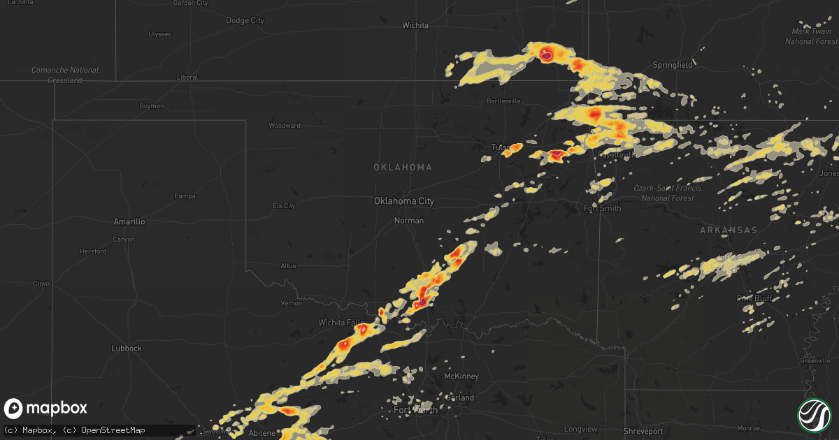
Hail Map on May 22, 2011
Get this storm
May 22 map
$229
one time, instant access
Download today. No call, no setup
Keep the $229
Bought the map and want the full workflow? Apply the entire $229 to a subscription within 7 days. None of it is wasted.
Every map, not just this one
This buys you this map. Subscription and you get every map we run, in the markets you choose from a few cities to whole states to nationwide. Plus real-time alerts the moment a storm fires.
Contact data
Name, contact info, occupancy, even credit band for addresses in the footprint. You go from where it hit to who to call.
Become the source they trust
Unlimited branding weather history reports on demand. You already have the documented answer ready for the property owner, and you are the one who showed up with it.
Property data and RoofTrace estimates
Pull up any address you have got, its value and the exact code rules for that jurisdiction, straight from One Click Code. Then RoofTrace estimates the squares, pitch, and roof value, priced the way you price.
States Impacted by Hail Map on May 22, 2011
Storm reports
Kansas
| Date | Description |
|---|---|
| 05/22/20115:58 PM CDT | A local report indicates 1.25 inch wind near 6 N OSWEGO |
| 05/22/20115:56 PM CDT | Public stated that it has been hailing for the past 30 minutes. |
| 05/22/20115:10 PM CDT | Storm spotters report golf ball size hail |
| 05/22/20115:03 PM CDT | A local report indicates 2.50 inch wind near 3 ENE COLUMBUS |
| 05/22/20114:45 PM CDT | Deputy had his windshield blown out from the hail. |
| 05/22/20114:45 PM CDT | A local report indicates 2.75 inch wind near 5 S PARSONS |
| 05/22/20114:40 PM CDT | A local report indicates 1.75 inch wind near WSW PARSONS |
| 05/22/20114:35 PM CDT | A local report indicates 1.75 inch wind near PARSONS |
| 05/22/20114:32 PM CDT | Storm spotter measured 60 mph wind gusts |
| 05/22/20114:32 PM CDT | A local report indicates 1.00 inch wind near MCCUNE |
| 05/22/20114:29 PM CDT | A local report indicates 1.75 inch wind near MCCUNE |
| 05/22/20114:21 PM CDT | A local report indicates 1.75 inch wind near 3 ESE DENNIS |
| 05/22/20114:19 PM CDT | A local report indicates 1.75 inch wind near PARSONS |
| 05/22/20114:19 PM CDT | A local report indicates 1.75 inch wind near MCCUNE |
| 05/22/20114:15 PM CDT | A local report indicates 1.75 inch wind near 8 NE PARSONS |
| 05/22/20114:13 PM CDT | A local report indicates 1.00 inch wind near 3 SE DENNIS |
| 05/22/20114:13 PM CDT | A local report indicates 1.00 inch wind near MCCUNE |
| 05/22/20114:10 PM CDT | Quarter to golfball sized hail. Also rotation in the clouds. |
| 05/22/20114:03 PM CDT | A local report indicates 1.75 inch wind near 1 E DENNIS |
| 05/22/20113:56 PM CDT | A local report indicates 1.50 inch wind near 1 N PARSONS |
| 05/22/20113:25 PM CDT | A local report indicates 1.00 inch wind near 5 S GALESBURG |
| 05/22/20112:30 PM CDT | A local report indicates 1.50 inch wind near 5 S THAYER |
| 05/22/20112:30 PM CDT | A local report indicates 1.50 inch wind near THAYER |
| 05/22/20116:43 AM CDT | A local report indicates 1.00 inch wind near 2 NW INDEPENDENCE |
| 05/22/20116:12 AM CDT | Trained spotter reports quarter...nickel and dime sized hail falling. |
| 05/22/20115:40 AM CDT | Delayed report |
| 05/21/20117:21 PM CDT | Trailer blown on to hwy aa and camp clack rd north of galena. Possible tornado damage. |
Utah
| Date | Description |
|---|---|
| 05/22/20115:50 PM CDT | Camel back mountain dpg06 - 5077 ft. |
| 05/22/20115:40 PM CDT | Playa station dpg09 - 4280 ft |
Alabama
| Date | Description |
|---|---|
| 05/22/20111:45 PM CDT | Tree down in ardmore estates at jordan ln. And oakwood ave. |
| 05/22/20111:25 PM CDT | Intersection of pulaski pike and sparkman dr. |
| 05/22/201112:55 PM CDT | Trees down |
Illinois
| Date | Description |
|---|---|
| 05/22/20116:58 PM CDT | Flagpole at dairy queen bent in half. Relayed by wrex. |
| 05/22/20116:56 PM CDT | Alpine road and harrison road in southeast rockford. |
| 05/22/20116:55 PM CDT | East side of rockford |
| 05/22/20116:55 PM CDT | Cocorahs observer. Delayed report. |
| 05/22/20116:54 PM CDT | Tree limbs down. Small ham radio towers down. |
| 05/22/20116:54 PM CDT | A local report indicates 61 MPH wind near ROCKFORD AIRPORT |
| 05/22/20116:53 PM CDT | Nickel to quarter size |
| 05/22/20116:50 PM CDT | *** 1 inj *** tree fell onto house on crosby street. Relayed by wrex. |
| 05/22/20116:50 PM CDT | Near i-90 and bus us-20. |
| 05/22/20116:50 PM CDT | Large tree branches down and debris flying through the air outside wrex studios. |
| 05/22/20116:50 PM CDT | Huffman blvd and auburn st. |
| 05/22/20116:49 PM CDT | Alpine road and harrison avenue in southeast rockford. |
| 05/22/20116:49 PM CDT | Several 4-5 inch diameter tree branches down. |
| 05/22/20116:43 PM CDT | Numerous 1 foot diameter trees down |
| 05/22/20116:40 PM CDT | Tornado began 2.9 miles north of stillman valley at meridian road and stillman valley road. It continued east for about half a mile. It was rated ef1 with a width of up |
| 05/22/20116:40 PM CDT | At hwy 20 and firewell bridge road trooper reports trees snapped in half...power poles down...cattle barn and pole barn damaged. Time estimated by radar. |
| 05/22/20116:38 PM CDT | 8 to 10 inch tree limbs down. Estimated one inch of rain in the last 30 minutes. |
| 05/22/20116:36 PM CDT | A local report indicates 65 MPH wind near E GERMAN VALLEY |
| 05/22/20116:35 PM CDT | Barns and buildings blown apart |
| 05/22/20116:35 PM CDT | A local report indicates 59 MPH wind near FREEPORT ALBERTUS AIRPO |
| 05/22/20116:35 PM CDT | Tree knocked down across road. |
| 05/22/20116:34 PM CDT | 70 to 80 mph nearly sustained for 5 to 6 minutes. Power poles snapped. Just s of town. Also pea sized hail. |
| 05/22/20116:32 PM CDT | A local report indicates 60 MPH wind near S FREEPORT |
| 05/22/20116:28 PM CDT | Tornado occurred 1 mile southeast of polo southeast of union road and judson road. It ended at judson and dailey road. It was rated ef1 with path length 1.5 miles and w |
| 05/22/20116:25 PM CDT | Tornado began on columbine road near route 72 and ended at kelly road near alworth road 1 mile south of winnebago in winnebago county. The tornado was rated ef1 with a |
| 05/22/20116:16 PM CDT | A local report indicates 1.00 inch wind near HANNA CITY |
| 05/22/20116:13 PM CDT | Branches down. |
| 05/22/20116:05 PM CDT | Relayed by wrex-tv |
| 05/22/20115:55 PM CDT | A local report indicates 1.25 inch wind near CANTON |
| 05/22/20115:54 PM CDT | Wind sustained at 45 with gusts to 60 mph |
| 05/22/20115:52 PM CDT | Delayed report. Time estimated. |
| 05/22/20115:48 PM CDT | A local report indicates 1.75 inch wind near GALVA |
| 05/22/20115:47 PM CDT | A local report indicates 1.00 inch wind near CAMBRIDGE |
| 05/22/20115:36 PM CDT | Us 251 and loves park dr. |
| 05/22/20115:09 PM CDT | A local report indicates 1.00 inch wind near MOUNT MORRIS |
| 05/22/20114:55 PM CDT | At 1359 e rd and 1129 n rd. |
| 05/22/20114:47 PM CDT | Power poles down between gilman and gibson city. |
| 05/22/20114:45 PM CDT | A local report indicates 58 MPH wind near ST. JOSEPH |
| 05/22/20114:42 PM CDT | A local report indicates 1.00 inch wind near ROCK FALLS |
| 05/22/20114:34 PM CDT | Estimated wind gusts of 50 to 60 mph. |
| 05/22/20114:02 PM CDT | Quarter to half doller sized hail at ashland rd and peotone-beecher rd. House fire started by lightning. |
| 05/22/20113:56 PM CDT | Traveling southward on il-1 |
| 05/22/20113:53 PM CDT | 2 miles s of beecher on il-1. |
| 05/22/20113:46 PM CDT | North st and il-50. |
| 05/22/20113:43 PM CDT | Tree down and grain bin blown over. |
| 05/22/20113:40 PM CDT | 3/4 in to 1 inch hail. 59th and halstead. Lasted around 8 minutes. |
| 05/22/20113:40 PM CDT | West side of city - 4-6 inch dia tree branches down. One 10 inch dia tree down at small park and a large branch fell on a van on west hawkins st. |
| 05/22/20113:40 PM CDT | Nickel to quarter size...lasted 5 minutes |
| 05/22/20113:18 PM CDT | Power went out |
| 05/22/20113:10 PM CDT | A local report indicates 67 MPH wind near 4 W MCLEAN |
| 05/22/20113:10 PM CDT | W madison st |
| 05/22/20113:07 PM CDT | E seegars rd |
| 05/22/20113:00 PM CDT | Dime to quarter size |
| 05/22/20112:54 PM CDT | A local report indicates 65 MPH wind near ELKHART |
| 05/22/20112:51 PM CDT | Also reported nickel size hail. |
| 05/22/20112:45 PM CDT | A local report indicates 1.00 inch wind near ATHENS |
| 05/22/20112:35 PM CDT | A local report indicates 1.00 inch wind near MIDDLETOWN |
| 05/22/20112:33 PM CDT | A local report indicates 1.00 inch wind near 1 NW ATHENS |
| 05/22/20112:31 PM CDT | A local report indicates 1.50 inch wind near SECOR |
| 05/22/20112:26 PM CDT | A local report indicates 66 MPH wind near 8 E PETERSBURG |
| 05/22/20112:26 PM CDT | A local report indicates 1.00 inch wind near 1 S EUREKA |
| 05/22/20112:15 PM CDT | A local report indicates 1.00 inch wind near GOODFIELD |
| 05/22/20112:10 PM CDT | A local report indicates 1.00 inch wind near JACKSONVILLE |
| 05/22/20112:10 PM CDT | A local report indicates 1.00 inch wind near DEER CREEK |
| 05/22/20112:05 PM CDT | A local report indicates 1.00 inch wind near JACKSONVILLE |
| 05/22/20111:46 PM CDT | A local report indicates 1.00 inch wind near 1 NNW TREMONT |
| 05/22/20111:27 PM CDT | A local report indicates 1.75 inch wind near 1 S MANITO |
| 05/22/20111:23 PM CDT | A local report indicates 1.00 inch wind near MANITO |
| 05/22/20111:22 PM CDT | A local report indicates 1.50 inch wind near 1 S MANITO |
| 05/22/20116:40 AM CDT | Damage at kennedy middle school at 4664 n. Rockton avenue in rockford. Roof almost all gone and pieces strewn about the property. Just north of there on rockton ave...t |
| 05/21/201111:50 PM CDT | Time estimated. Large tree down blocking sherman road. |
| 05/21/20118:34 PM CDT | 60 to 70 mph wind w/ zero visibility due to heavy rain |
| 05/21/20118:30 PM CDT | Small barn destroyed at spotters residence. Time estimated. Delayed report |
| 05/21/20118:19 PM CDT | Wind gusts estimated to 60 mph. Noted branches down and shelf cloud overhead...moving northeast. |
| 05/21/20118:04 PM CDT | Time estimated - tree down over road |
| 05/21/20118:04 PM CDT | A door blown 50-60 yards into a house. A small shed also blown down. Time estimated off radar. Correction to location. |
| 05/21/20118:00 PM CDT | A local report indicates 1.00 inch wind near ABINGDON |
| 05/21/20117:59 PM CDT | Numerous 2 inch tree limbs down. |
| 05/21/20117:40 PM CDT | A local report indicates 1.75 inch wind near 2 SE CAMERON |
| 05/21/20117:40 PM CDT | Trees blown down blocking both lanes to access of lake calhoun golf course. |
| 05/21/20117:29 PM CDT | Trees uprooted. Route 12 blocked by tree east of route 31. |
| 05/21/20117:25 PM CDT | Power out east of route 47. Large trees down. Fence down at school. |
| 05/21/20117:25 PM CDT | Estimated 8 inch tree down blocking us-150 approximately 1/4 mile east of spoon river. |
| 05/21/20117:21 PM CDT | Lots of dime and nickles...some golfballs |
| 05/21/20117:18 PM CDT | A local report indicates 1.00 inch wind near 1 SSW KEWANEE |
| 05/21/20117:10 PM CDT | Near i90 and us 20. 1/4 mi e of chrysler plant. |
| 05/21/20117:09 PM CDT | Pea sized hail and tree limbs down. |
| 05/21/20117:08 PM CDT | A local report indicates 1.00 inch wind near 3 E GALVA |
| 05/21/20117:05 PM CDT | At cemetary |
| 05/21/20117:04 PM CDT | Small tree branches blown down. Estimated wind gusts about 50 mph. |
| 05/21/20117:04 PM CDT | Trees and wires down all across northern portion of county. |
| 05/21/20117:00 PM CDT | Covering ground...northeast portion of the city. |
| 05/21/20117:00 PM CDT | Possible tornado. Damage noted to roscoe fd and training facility. Multiple firefighters witnessed funnel cloud prior. Asst. |
Minnesota
| Date | Description |
|---|---|
| 05/22/20114:29 PM CDT | Reported by off duty nws employee at 445pm. Time of event estimated by radar. Some melting of hail had already occurred. |
| 05/22/20114:21 PM CDT | Possible brief tornado touchdown. Several trees snapped off and branches thrown. 80 yards wide damage just north of root river on hwy 26. Reported by off duty nws emplo |
| 05/22/20114:16 PM CDT | 1 foot diameter pine tree snapped. Wind estimated 60 mph. |
| 05/22/20114:15 PM CDT | A local report indicates 60 MPH wind near HOKAH |
| 05/22/20114:00 PM CDT | Storm survey conducted 5/23. The tornado began one half mile west of the intersection of highway 22 and 76 in central houston county. The most significant damage was 5 |
| 05/22/20113:49 PM CDT | Tornado damage..pole barn and house with extensive damage |
| 05/22/20113:40 PM CDT | Medium to small branches down...shingles blown off roofs |
| 05/22/20113:31 PM CDT | Tornado damage report of roofs and second stories of houses missing or damaged. |
| 05/22/20113:27 PM CDT | Damage to silos...roofs. 1/2 n of harmony |
| 05/22/20113:25 PM CDT | 1-2 ft dia trees down..flag pole snapped in half. Trrees blown down in dirrerent directions. Narrow damage path. Possible tornado |
| 05/22/20113:25 PM CDT | Caught on video nr cr36 and ivywood trail |
| 05/22/20113:21 PM CDT | Tornado on ground. |
| 05/22/20113:20 PM CDT | County rd 44/15. Tornado on ground |
| 05/22/20113:19 PM CDT | A local report indicates a tornado near 3 ESE FOREST LAKE |
| 05/22/20113:16 PM CDT | South of forest lake near jct 35w and 35e |
| 05/22/20113:04 PM CDT | Barn damaged 3 miles north of granger |
| 05/22/20113:02 PM CDT | Tornado on ground. |
| 05/22/20112:52 PM CDT | Rated ef-0. Path length 0.2 mile. Trees damaged. |
| 05/22/20112:47 PM CDT | 12 to 18 inch tree limbs down in theo. Wirth park...spotter says posible tornado |
| 05/22/20112:45 PM CDT | Central ave. And 73rd st 6 inch tree limbs down |
| 05/22/20112:45 PM CDT | Followup report...south of 12th and upton extensive tree damage some structure damage as well...appears to be wind not tornado damage |
| 05/22/20112:35 PM CDT | A local report indicates 1.00 inch wind near 5 SE RED WING |
| 05/22/20112:34 PM CDT | 51st and university avenue...roof off house |
| 05/22/20112:30 PM CDT | Also wind damage to garden sheds at highway 100 and 694 |
| 05/22/20112:27 PM CDT | 29th and logan north |
| 05/22/20112:23 PM CDT | At highway 694 over mississippi river |
| 05/22/20112:16 PM CDT | Debris cloud highway 100 and 394..surface level rotation |
| 05/22/20112:16 PM CDT | Trees down 21st and thomas north |
| 05/22/20112:01 PM CDT | A local report indicates 1.50 inch wind near WANAMINGO |
| 05/22/20111:53 PM CDT | A local report indicates 1.00 inch wind near HAYFIELD |
| 05/22/201112:59 PM CDT | A local report indicates 1.00 inch wind near 2 S WASECA |
Wisconsin
| Date | Description |
|---|---|
| 05/22/20116:39 PM CDT | A local report indicates 60 MPH wind near RANDOM LAKE |
| 05/22/20116:38 PM CDT | Tornado on the ground |
| 05/22/20116:36 PM CDT | Covering the ground. |
| 05/22/20116:35 PM CDT | A local report indicates 1.50 inch wind near ARNOTT |
| 05/22/20116:35 PM CDT | A local report indicates 1.25 inch wind near PLOVER |
| 05/22/20116:30 PM CDT | Delayed report. Smoking power pole |
| 05/22/20116:30 PM CDT | A local report indicates 1.75 inch wind near KELLNER |
| 05/22/20116:30 PM CDT | Hwy 54 and i-39. Tornado on the ground. |
| 05/22/20116:30 PM CDT | Barn and silo destroyed near 1049 county west rd. Barn destroyed near 6487 eckels rd. Barn destroyed near 169 steward rd and county rd bb. |
| 05/22/20116:29 PM CDT | Several reports of major damage. Tornado went through grand rapids. Location estimated. |
| 05/22/20116:27 PM CDT | At the sullivan nws office...3 miles southeast of the village of sullivan. |
| 05/22/20116:26 PM CDT | Brief tornado. Rated ef-0. |
| 05/22/20116:23 PM CDT | A local report indicates 1.75 inch wind near WISCONSIN RAPIDS |
| 05/22/20116:19 PM CDT | Hail ranging from half to one inch. Lasted about 3 minutes. |
| 05/22/20116:18 PM CDT | A local report indicates 1.75 inch wind near PALMYRA |
| 05/22/20116:16 PM CDT | 3 to 4 houses damaged in the saratoga township. 1 garage destroyed near hwy 73 and county road evergreen. 3 minor injuries in saratoga. Several large power poles down n |
| 05/22/20116:16 PM CDT | Structure damage and a barn missing. |
| 05/22/20116:14 PM CDT | A local report indicates 1.00 inch wind near 2 S WISCONSIN RAPIDS |
| 05/22/20116:13 PM CDT | Shed destroyed near county road h and willow road reported by law enforcement. Location is estimated...damage could be from a possible tornado. |
| 05/22/20116:13 PM CDT | Spotter estimates 55 to 60 mph wind gust |
| 05/22/20116:13 PM CDT | Shed destroyed near county road h and willow road reported by law enforcement. Location is estimated...damage could be from a possible tornado. |
| 05/22/20116:13 PM CDT | Tornado on the ground just northeast of phillips |
| 05/22/20116:13 PM CDT | Tornado on the ground |
| 05/22/20116:13 PM CDT | Several large trees blown down. |
| 05/22/20116:10 PM CDT | Estimated 55 to 60 mph gusts |
| 05/22/20116:08 PM CDT | Delayed report. Trees and wires down. |
| 05/22/20116:08 PM CDT | A local report indicates 1.00 inch wind near NEKOOSA |
| 05/22/20116:07 PM CDT | A local report indicates 1.00 inch wind near 5 SSE WHITEWATER |
| 05/22/20116:06 PM CDT | On hwy 80 |
| 05/22/20116:05 PM CDT | Trees down...power outages...and damage to a fence in the hustisford area...at intersection of highway e and highway 60. |
| 05/22/20116:01 PM CDT | 1.9 mile path length. Max path width 0.21 miles. Rated ef-0. |
| 05/22/20116:01 PM CDT | Corrected from earlier report...spotter measured a stone to confirm size. |
| 05/22/20116:01 PM CDT | A local report indicates 1.00 inch wind near 2 N RICHLAND CENTER |
| 05/22/20115:59 PM CDT | Delayed report. Tree down. |
| 05/22/20115:57 PM CDT | On county road zz. |
| 05/22/20115:56 PM CDT | On the north side of watertown. |
| 05/22/20115:56 PM CDT | A high power transmission line collapsed near county road f and 13th ave along the finley and armenia township lines. |
| 05/22/20115:56 PM CDT | At highway zz and 14. |
| 05/22/20115:55 PM CDT | A local report indicates 1.00 inch wind near BABCOCK |
| 05/22/20115:55 PM CDT | A local report indicates 58 MPH wind near FORT ATKINSON |
| 05/22/20115:52 PM CDT | Brief spin up. Rated ef-0. |
| 05/22/20115:51 PM CDT | Marble to quarter size hail |
| 05/22/20115:39 PM CDT | 1 mile path. 0.22 miles wide. Rated ef-0. |
| 05/22/20115:39 PM CDT | A local report indicates 1.00 inch wind near DYCKESVILLE |
| 05/22/20115:36 PM CDT | A local report indicates 1.00 inch wind near 1 N CLYMAN |
| 05/22/20115:34 PM CDT | A local report indicates 1.00 inch wind near LAKE MILLS |
| 05/22/20115:33 PM CDT | A local report indicates 1.50 inch wind near 2 S KENNAN |
| 05/22/20115:32 PM CDT | Large tree branches blown down. |
| 05/22/20115:29 PM CDT | Outbuildings destroyed at farmstead. |
| 05/22/20115:29 PM CDT | A local report indicates 1.00 inch wind near WRIGHTSTOWN |
| 05/22/20115:24 PM CDT | Roff damage...debris...and tree damage on egress ave n of county e. |
| 05/22/20115:21 PM CDT | A local report indicates 1.75 inch wind near KAUKAUNA |
| 05/22/20115:20 PM CDT | A local report indicates 1.50 inch wind near 8 SE APPLETON |
| 05/22/20115:18 PM CDT | At the intersection of mason and packerland. Power pole down. |
| 05/22/20115:18 PM CDT | A local report indicates 1.50 inch wind near 5 WSW WARRENS |
| 05/22/20115:15 PM CDT | A local report indicates 1.00 inch wind near DARBOY |
| 05/22/20115:15 PM CDT | Damage survey was done 5/23. Tornado formed 4 miles northwest of tomah near county road m. The maximum damage was ef2 in several locations along its path. At its widest |
| 05/22/20115:15 PM CDT | A local report indicates 1.00 inch wind near 2 NW DARBOY |
| 05/22/20115:14 PM CDT | Large trees blown down. |
| 05/22/20115:12 PM CDT | Dime to quarter |
| 05/22/20115:11 PM CDT | Lawerence campus. |
| 05/22/20115:10 PM CDT | A local report indicates 1.50 inch wind near HOWARD |
| 05/22/20115:06 PM CDT | At fox valley tech college |
| 05/22/20115:05 PM CDT | Delayed report |
| 05/22/20115:05 PM CDT | A local report indicates 60 MPH wind near GREEN BAY |
| 05/22/20115:03 PM CDT | At the nwtc campus |
| 05/22/20115:00 PM CDT | Reported by fire department |
| 05/22/20115:00 PM CDT | Damage to buildings on south side of sparta |
| 05/22/20114:59 PM CDT | A local report indicates 1.00 inch wind near BARRE MILLS |
| 05/22/20114:58 PM CDT | A local report indicates 60 MPH wind near 1 S SPARTA |
| 05/22/20114:58 PM CDT | A local report indicates 1.00 inch wind near OSHKOSH |
| 05/22/20114:58 PM CDT | Measured 1.7 inch |
| 05/22/20114:56 PM CDT | Preliminary damage assessment by nws. Low end ef1 tornado on south side of sparta. 70 yards wide but not a continuous path toward warrens. Time estimated by spotter rep |
| 05/22/20114:56 PM CDT | At i90 exit 25 |
| 05/22/20114:56 PM CDT | Cars flipped...turned...debris impact has destroyed numerous windows at brennegen chev dealer. |
| 05/22/20114:55 PM CDT | A local report indicates 1.25 inch wind near SUN PRAIRIE |
| 05/22/20114:55 PM CDT | Tornado formed at 455 pm and tracked 2 miles with a maximum width of 70 yards and ef1 damage. The tornado dissipated at 500 pm 2 miles southeast of sparta. |
| 05/22/20114:55 PM CDT | Some trees snapped off and billboards down. |
| 05/22/20114:52 PM CDT | A local report indicates 1.00 inch wind near 1 N SUN PRAIRIE |
| 05/22/20114:49 PM CDT | Delayed report |
| 05/22/20114:47 PM CDT | Power pole and tree limbs down along babit avenue on the north side of gilman. Time radar estimated. |
| 05/22/20114:45 PM CDT | A local report indicates 1.00 inch wind near BLACK CREEK |
| 05/22/20114:40 PM CDT | Some small trees and tree branches blown down east on highway 70 towards couderay. |
| 05/22/20114:37 PM CDT | A few trees blown down along county road ii |
| 05/22/20114:35 PM CDT | Some tops of trees were broken off along county road m. |
| 05/22/20114:33 PM CDT | A local report indicates 1.75 inch wind near 1 E NEW LONDON |
| 05/22/20114:30 PM CDT | A local report indicates 1.75 inch wind near 2 SE NEW LONDON |
| 05/22/20114:27 PM CDT | Some small trees and tree branches down near hwy 70/27 intersection. |
| 05/22/20114:26 PM CDT | A local report indicates 1.25 inch wind near DALE |
| 05/22/20114:26 PM CDT | Measured near 16th street and denton in la crosse as tornado passed by. Anemometer is at 35 feet. |
| 05/22/20114:25 PM CDT | Tree down near 19th and denton |
| 05/22/20114:23 PM CDT | Damage survey conducted 5/23. Tornado moved off the mississippi river at 423 pm near green island park causing lower end ef-2 damage. The path continued east-northeast |
| 05/22/20114:18 PM CDT | Several trees down |
| 05/22/20114:12 PM CDT | A local report indicates 1.50 inch wind near 1 W GREENVILLE |
| 05/22/20114:07 PM CDT | A local report indicates 1.25 inch wind near 1 N DALE |
| 05/22/20114:07 PM CDT | A local report indicates 1.50 inch wind near 2 NW LARSEN |
| 05/22/20114:07 PM CDT | A local report indicates 1.00 inch wind near 2 S CHIPPEWA FALLS |
| 05/22/20114:06 PM CDT | A local report indicates 1.00 inch wind near LAKE POYGAN |
| 05/22/20114:06 PM CDT | A local report indicates 1.00 inch wind near SCANDINAVIA |
| 05/22/20114:05 PM CDT | Hwy 10 and 45 |
| 05/22/20114:01 PM CDT | On hwy 10. |
| 05/22/20114:00 PM CDT | Possible torndao. 2 homes sustained roof damage with numerous trees down between mikana and brill. |
| 05/22/20113:57 PM CDT | Sporadic tree damage from near and east of butternut to the northeast into the area just northwest of the turtle flambeau flowage. Also a large volume of hail fell in b |
| 05/22/20113:50 PM CDT | A local report indicates 1.00 inch wind near AMHERST |
| 05/22/20113:47 PM CDT | A local report indicates 1.50 inch wind near BORTH |
| 05/22/20113:45 PM CDT | A local report indicates 2.00 inch wind near 2 SW POY SIPPI |
| 05/22/20113:41 PM CDT | Small branches down. Penny size hail. |
| 05/22/20113:35 PM CDT | Covering ground. |
| 05/22/20113:23 PM CDT | A local report indicates 1.00 inch wind near 6 SW BUTTERNUT |
| 05/22/20113:22 PM CDT | Reported along murphy rd...neshkoro. Time estimated from radar...delayed report. |
| 05/22/20113:20 PM CDT | A local report indicates 1.75 inch wind near 5 W NESHKORO |
| 05/22/20113:20 PM CDT | North side of crystal lake |
| 05/22/20113:20 PM CDT | A local report indicates 1.00 inch wind near 4 SSW WAUTOMA |
| 05/22/20113:15 PM CDT | Had ping pong to golf ball size hail in elmwood. Also had gusty winds...but no reports of wind damage. |
| 05/22/20113:15 PM CDT | Report of damage to barns and outbuildings. Also a 6 mile stretch of downed trees from the southwest to northeast...a mile or two south and east of butternut. Damage ti |
| 05/22/20113:14 PM CDT | A local report indicates 1.50 inch wind near 3 W ELMWOOD |
| 05/22/20113:14 PM CDT | 80 ft silo knocked down. Barn and pole building destroyed. Delayed report. Time estimated by radar. |
| 05/22/20113:12 PM CDT | A local report indicates 1.00 inch wind near 4 NW ELMWOOD |
| 05/22/20113:10 PM CDT | A local report indicates 2.75 inch wind near 1 S WESTFIELD |
| 05/22/20113:07 PM CDT | Minor damage to siding on a home and barn severly damaged. |
| 05/22/20113:05 PM CDT | A local report indicates 4.25 inch wind near 1 E WESTFIELD |
| 05/22/20113:04 PM CDT | A local report indicates 1.00 inch wind near 3 N BUTTERNUT |
| 05/22/20113:04 PM CDT | Cracked windshields of autos |
| 05/22/20113:04 PM CDT | 12-14 inch diameter trees down across kley rd |
| 05/22/20113:01 PM CDT | A local report indicates 2.00 inch wind near WESTFIELD |
| 05/22/20113:00 PM CDT | A local report indicates 2.00 inch wind near WESTFIELD |
| 05/22/20112:52 PM CDT | A local report indicates 1.00 inch wind near BIG FLATS |
| 05/22/20112:44 PM CDT | A local report indicates 2.75 inch wind near MAUSTON |
| 05/22/20112:39 PM CDT | Numerous large trees blown down and snapped. |
| 05/22/20112:38 PM CDT | Trees reported down along price lakes rd south of hwy 70. Likely associated with the first storm that moved through the area. |
| 05/22/20112:35 PM CDT | Trees down along county highway w near price and sawyer county border. Time is estimated from radar. |
| 05/22/20112:35 PM CDT | Hail accumulated to a depth of 6 inches along the sides of the roads. |
| 05/22/20112:33 PM CDT | 2.8 mile path length to the nne from starting point. Mainly tree damage. Rated low-end ef-1. |
| 05/22/20112:30 PM CDT | A local report indicates 1.25 inch wind near 5 N MAUSTON |
| 05/22/20112:30 PM CDT | A local report indicates 1.00 inch wind near MARSHFIELD |
| 05/22/20112:28 PM CDT | Numerous large trees blown over and snapped. |
| 05/22/20112:26 PM CDT | Numerous large trees blown down and snapped. |
| 05/22/20112:25 PM CDT | At flambeau river state park headquarters. Some sporadic tree damage with a few limbs broken off or trees snapped across parts of the state forest. |
| 05/21/20118:07 PM CDT | 53 knot wind gust at airport. |
| 05/21/20118:02 PM CDT | Roofing torn off days inn at 13th and college. Estimated 60 mph winds. |
| 05/21/20117:54 PM CDT | A local report indicates 60 MPH wind near UNION GROVE |
| 05/21/20117:52 PM CDT | Pea size hail also falling. |
| 05/21/20117:50 PM CDT | Efo tornado started 0.3 miles nw of markesan and ended 4.5 miles nne of markesan. Path width 50 yds...path length 4.7 miles. Tornado began at 750 pm and ended at 757 pm |
| 05/21/20117:50 PM CDT | Trees and power lines downed by thunderstorm. Emergency manager to investigate further. |
| 05/21/20117:50 PM CDT | Roof torn off a home |
| 05/21/20117:49 PM CDT | Trees down in the town of brighton. |
| 05/21/20117:48 PM CDT | Trees down in the town of salem. |
| 05/21/20117:47 PM CDT | Efo tornado started 0.3 miles nw of markesan and ended 4.5 miles nne of markesan. Path width 50 yds...path length 4.7 miles. Tornado began at 747 pm and ended at 755 pm |
| 05/21/20117:45 PM CDT | Ef0 tornado spun up at an estimated time of 745 pm and lasted less than 1 minute. Estimated winds of 70 mph. There was damage to large tree branches...a shed door at a |
| 05/21/20117:33 PM CDT | Ef0 tornado spun up at an estimated time of 733 pm and lasted less than 1 minute. Estimated winds of 70 mph. There was damage to large tree branches...a shed door at a |
| 05/21/20117:11 PM CDT | A local report indicates 1.00 inch wind near 4 S SCANDINAVIA |
| 05/21/20117:06 PM CDT | Tree down blocking road. Delayed report...time of damage estimated from doppler radar imagery. |
| 05/21/20117:05 PM CDT | A local report indicates 60 MPH wind near 1 W BELOIT |
North Dakota
| Date | Description |
|---|---|
| 05/21/20118:41 PM CDT | Sheriffs deputy reported two brief tornado touchdowns. Funnel cloud has since dissipated with no rotation noted. |
Oklahoma
| Date | Description |
|---|---|
| 05/22/20116:55 PM CDT | A local report indicates 2.75 inch wind near RYAN |
| 05/22/20116:52 PM CDT | A local report indicates 1.00 inch wind near RYAN |
| 05/22/20116:50 PM CDT | Large trees down blocking road |
| 05/22/20116:30 PM CDT | Structures damaged in cleora area. Time estimated via radar. |
| 05/22/20116:22 PM CDT | A local report indicates 2.75 inch wind near S ADA |
| 05/22/20116:22 PM CDT | A local report indicates 1.50 inch wind near 6 WSW MAZIE |
| 05/22/20116:21 PM CDT | A local report indicates 2.50 inch wind near 3 S ADA |
| 05/22/20116:18 PM CDT | A local report indicates 1.25 inch wind near 4 N PEORIA |
| 05/22/20116:07 PM CDT | A local report indicates 1.00 inch wind near 3 E VINITA |
| 05/22/20115:47 PM CDT | A local report indicates 1.75 inch wind near SULPHUR |
| 05/22/20115:38 PM CDT | A local report indicates 2.50 inch wind near DOUGHERTY |
| 05/22/20115:32 PM CDT | A local report indicates 1.00 inch wind near 8 S DAVIS |
| 05/22/20115:29 PM CDT | A local report indicates 2.75 inch wind near GENE AUTRY |
| 05/22/20115:29 PM CDT | A local report indicates 2.75 inch wind near SPRINGER |
| 05/22/20115:23 PM CDT | A local report indicates 2.75 inch wind near 3 SSW SPRINGER |
| 05/22/20115:18 PM CDT | A local report indicates 1.75 inch wind near ARDMORE |
| 05/22/20115:17 PM CDT | Windows busted out of multiple cars |
| 05/22/20115:17 PM CDT | Barn blown down |
| 05/22/20115:14 PM CDT | A local report indicates 4.25 inch wind near LONE GROVE |
| 05/22/20115:13 PM CDT | A local report indicates 1.75 inch wind near 12 NW MARIETTA |
| 05/22/20115:13 PM CDT | A local report indicates 1.75 inch wind near LONE GROVE |
| 05/22/20115:00 PM CDT | A local report indicates 1.75 inch wind near 4 S WILSON |
| 05/22/20116:30 AM CDT | A local report indicates 3.20 inch wind near 5 WNW APACHE |
| 05/21/201111:53 PM CDT | A local report indicates 1.00 inch wind near 1 NNE VERDIGRIS |
| 05/21/201111:05 PM CDT | A local report indicates 1.75 inch wind near 1 SSW CATOOSA |
| 05/21/201110:58 PM CDT | A local report indicates 70 MPH wind near CAMERON |
| 05/21/201110:55 PM CDT | Numerous reports across le flore county of trees and power line damage. |
| 05/21/201110:46 PM CDT | Measured at wfo tulsa |
| 05/21/201110:45 PM CDT | 41st and yale |
| 05/21/201110:45 PM CDT | A local report indicates 2.00 inch wind near 2 SE CATOOSA |
| 05/21/201110:35 PM CDT | 41st and sheridan |
| 05/21/201110:32 PM CDT | 41st and harvard |
| 05/21/20119:52 PM CDT | A local report indicates 70 MPH wind near SUMMERFIELD |
| 05/21/20118:45 PM CDT | Damage to at least one home. Emergency vehicles en route. Possible tornado. |
| 05/21/20118:44 PM CDT | Mobile home park consisting of six homes at 690 rd and highway 412...was destroyed. |
| 05/21/20118:42 PM CDT | A local report indicates 60 MPH wind near 2 E LOCUST GROVE |
| 05/21/20118:40 PM CDT | Mobile home park destroyed. Six trailers 1 mile ene of dripping springs ok. Probable tornado. |
| 05/21/20118:30 PM CDT | On the ground for about 5 minutes. |
| 05/21/20118:27 PM CDT | A local report indicates 1.75 inch wind near PEGGS |
| 05/21/20118:14 PM CDT | On the ground for about 5 minutes. |
| 05/21/20118:08 PM CDT | A local report indicates 1.00 inch wind near 2 SE VANOSS |
| 05/21/20117:56 PM CDT | Asos observation at kmko 6 miles south of muskogee |
| 05/21/20117:56 PM CDT | A local report indicates 60 MPH wind near MUSKOGEE |
| 05/21/20117:42 PM CDT | A local report indicates 2.75 inch wind near PEGGS |
| 05/21/20117:40 PM CDT | I-35 exit 55 |
| 05/21/20117:39 PM CDT | A local report indicates 2.00 inch wind near 3 W SCRAPER |
| 05/21/20117:28 PM CDT | Hwy 76 and ranch road |
| 05/21/20117:26 PM CDT | *** 2 inj *** delayed report...a storm survey concluded that an ef-3 tornado crossed into mcdonald county missouri from oklahoma 3 miles north of southwest city and tra |
| 05/21/20117:20 PM CDT | Significant damage to several homes. Boat docks severely damaged. |
| 05/21/20117:15 PM CDT | A local report indicates 61 MPH wind near 1 N RINGLING |
| 05/21/20117:10 PM CDT | A local report indicates 4.25 inch wind near 2 N PEGGS |
| 05/21/20117:03 PM CDT | At valley view hospital |
| 05/21/20117:00 PM CDT | A local report indicates 1.00 inch wind near WELEETKA |
| 05/21/20117:00 PM CDT | Trees uprooted |
Ohio
| Date | Description |
|---|---|
| 05/22/20116:28 PM CDT | Two large trees snapped...both falling on separate mobile homes...destroying the homes. Separate large tree uprooted also in the same area. |
| 05/22/20116:10 PM CDT | Trees down. |
| 05/22/20116:00 PM CDT | Tree down on mobile home. |
| 05/22/20115:30 PM CDT | A few trees down |
| 05/22/20114:38 PM CDT | A local report indicates 1.00 inch wind near WHITE OAK |
| 05/22/20114:37 PM CDT | A local report indicates 2.00 inch wind near DENT |
| 05/22/20114:30 PM CDT | A local report indicates 1.00 inch wind near MORROW |
| 05/22/20114:25 PM CDT | A local report indicates 1.25 inch wind near PLEASANT PLAIN |
| 05/22/20114:15 PM CDT | Numerous healthy trees down. Tree down on a house. One inch hail. Two to three inches of water on roadways. |
| 05/22/20114:13 PM CDT | Trees down. Pea size hail also reported. |
| 05/22/20114:08 PM CDT | A local report indicates 1.00 inch wind near MAINEVILLE |
| 05/22/20114:08 PM CDT | A local report indicates 1.00 inch wind near NORTH BEND |
| 05/22/20114:08 PM CDT | A local report indicates 1.25 inch wind near HAMILTON |
| 05/22/20114:08 PM CDT | A local report indicates 1.25 inch wind near PIKETON |
| 05/22/20114:05 PM CDT | A local report indicates 1.75 inch wind near 1 N HAMILTON |
| 05/22/20113:59 PM CDT | A local report indicates 1.00 inch wind near HAMILTON |
| 05/22/20113:40 PM CDT | Two trees down. |
| 05/22/20113:26 PM CDT | A local report indicates 1.25 inch wind near FAIRFIELD |
| 05/22/20113:22 PM CDT | A local report indicates 1.00 inch wind near 1 E WASHINGTON COURT HO |
| 05/22/20113:03 PM CDT | Trees down |
| 05/22/20112:53 PM CDT | A local report indicates 1.00 inch wind near LEESBURG |
| 05/22/20112:45 PM CDT | A local report indicates 1.75 inch wind near 4 N SEAMAN |
| 05/22/20112:25 PM CDT | A local report indicates 1.00 inch wind near LEBANON |
| 05/22/20112:21 PM CDT | A local report indicates 1.00 inch wind near LEBANON |
West Virginia
| Date | Description |
|---|---|
| 05/22/20116:40 PM CDT | Trees and a power line down on cabin creek road |
| 05/22/20116:24 PM CDT | Power lines are down on oakland walk |
| 05/22/20113:20 PM CDT | A local report indicates 1.00 inch wind near EAST LYNN |
| 05/22/20113:11 PM CDT | A local report indicates 1.00 inch wind near WAYNE |
North Carolina
| Date | Description |
|---|---|
| 05/22/20116:58 PM CDT | A local report indicates 1.00 inch wind near 5 S RENNERT |
| 05/22/20116:33 PM CDT | A local report indicates 1.00 inch wind near TODD |
| 05/22/20116:28 PM CDT | Report from quick road south of lumber bridge |
| 05/22/20116:27 PM CDT | Multiple trees down including a large oak snapped halfway up. Fence destroyed. |
| 05/22/20116:24 PM CDT | A local report indicates 1.75 inch wind near 1 NW TODD |
| 05/22/20116:17 PM CDT | Several trees down by wind and couple struck by lightning. |
| 05/22/20116:05 PM CDT | Roof blown off a trailer and laying beside the home. Time estimated. |
| 05/22/20116:03 PM CDT | Quarter size hail reported at the short stop food mart. Lasted approx 10 min. |
| 05/22/20116:02 PM CDT | Hail ranging from quarter to golfball size. |
| 05/22/20115:55 PM CDT | Golf ball size hail |
| 05/22/20115:45 PM CDT | 5 trees down on three mile hwy/hwy 194. |
| 05/22/20115:38 PM CDT | Several trees down on and along prices creek road. |
| 05/22/20115:30 PM CDT | A local report indicates 1.00 inch wind near MARSHALL |
| 05/22/20115:03 PM CDT | Em relayed reports of golf ball sie hail in the mars hill area |
| 05/22/20115:03 PM CDT | Em reported a tree on a house in mars hill...with other trees down between marshall and mars hill |
| 05/22/20114:35 PM CDT | Spotter reports golfball size hail |
| 05/21/20119:22 PM CDT | Church under construction destroyed...numerous large trees snapped off and power lines down. |
| 05/21/20119:00 PM CDT | Tree down at davie academy and hwy 64. |
| 05/21/20118:40 PM CDT | Tree across jennings and lentz rd |
| 05/21/20118:38 PM CDT | Tree down along nixon rd and chipley ford rd |
| 05/21/20118:35 PM CDT | Tree across myrtle rd |
| 05/21/20118:28 PM CDT | Trees across 1100 block of pisgah church rd...near harris bridge rd. |
| 05/21/20118:26 PM CDT | A local report indicates 67 MPH wind near NEWTON |
| 05/21/20118:26 PM CDT | Trees down across antietam rd |
| 05/21/20118:24 PM CDT | Church under construction destroyed...numerous large trees snapped off and power lines down. |
| 05/21/20118:23 PM CDT | Trees down across old mountain rd |
| 05/21/20118:22 PM CDT | *** 1 inj *** tree blown down on car. Driver injured and taken to hospital. |
| 05/21/20118:06 PM CDT | Trees across falling creek rd |
| 05/21/20118:03 PM CDT | Tree across horseshoe bend rd |
| 05/21/20117:55 PM CDT | Tree on powerlines helton rd |
| 05/21/20117:45 PM CDT | Many trees down across the city. |
| 05/21/20117:35 PM CDT | Several trees down. |
| 05/21/20117:35 PM CDT | Many trees and powerlines down. |
| 05/21/20117:35 PM CDT | A local report indicates 68 MPH wind near 4 W GLEN ALPINE |
Kentucky
| Date | Description |
|---|---|
| 05/22/20115:00 PM CDT | A local report indicates 1.00 inch wind near ULYSSES |
| 05/22/20114:55 PM CDT | A local report indicates 1.00 inch wind near 3 SW ULYSSES |
| 05/22/20114:45 PM CDT | 2 miles ese sandy hook. |
| 05/22/20114:36 PM CDT | Trees and powerlines were reported to have been blown down. |
| 05/22/20114:30 PM CDT | A local report indicates 1.00 inch wind near 1 WNW LEISURE |
| 05/22/20114:29 PM CDT | Trees and powerlines were reported to have been blown down. |
| 05/22/20114:20 PM CDT | Dime to quarter sized hail observed |
| 05/22/20114:20 PM CDT | A local report indicates 1.25 inch wind near RUSH |
| 05/22/20114:19 PM CDT | A local report indicates 1.00 inch wind near 5 SSE OWINGSVILLE |
| 05/22/20114:05 PM CDT | Power lines down on a house. |
| 05/22/20113:52 PM CDT | A local report indicates 1.00 inch wind near FORAKER |
| 05/22/20113:50 PM CDT | A tree was blown down near kentucky highway 15. Time of event is estimated from radar. |
| 05/22/20113:36 PM CDT | Tree blown down along highway 451 west of hazard. Time of event is estimated from radar. |
| 05/22/20113:35 PM CDT | Numerous trees down. |
| 05/22/20113:32 PM CDT | A tree was reported to have been blown down along county road. Event time is estimated from radar. |
| 05/22/20113:28 PM CDT | A tree was reported to have been blown down. Event time is estimated from radar. |
| 05/22/20113:25 PM CDT | A tree was reported to have been blown down along homestead drive. Event time is estimated from radar. |
| 05/22/20113:20 PM CDT | A tree was reported to have been blown down along ky highway 39. Event time is estimated from radar. |
| 05/22/20113:15 PM CDT | A tree was reported to have been blown down. Event time is estimated from radar. |
| 05/22/20113:10 PM CDT | Trees were reported to have been blown down. |
| 05/22/20113:05 PM CDT | A few trees and large limbs were reported to have been blown down. Time of event is estimated from radar. |
| 05/22/20113:05 PM CDT | Hail was reported to have fallen for about 5 minutes. |
| 05/22/20113:03 PM CDT | Trees reported down. |
| 05/22/20113:00 PM CDT | County dispatch reports trees down along kentucky highway 587. Time is estimated from radar. |
| 05/22/20112:45 PM CDT | Two trees were reported to have been blown down along ky highway 11 in the northern end of the county. |
| 05/22/20112:40 PM CDT | Numerous trees down in the city. |
| 05/22/20112:35 PM CDT | County dispatch reports trees down along kentucky highway 577. |
| 05/22/20112:35 PM CDT | A local report indicates 58 MPH wind near 3 N COLUMBIA |
| 05/22/20112:33 PM CDT | Numerous trees reported down. |
| 05/22/20112:20 PM CDT | A local report indicates 70 MPH wind near 6 E MUNFORDVILLE |
| 05/22/20112:17 PM CDT | Tree down on bunnell crossong road. |
| 05/22/20112:12 PM CDT | A few small limbs down. |
| 05/22/20111:52 PM CDT | A local report indicates 60 MPH wind near CLARKSON |
| 05/22/20111:26 PM CDT | Trees down in sprinfield neighborhood. |
| 05/22/20115:42 AM CDT | Tree across roots road. |
| 05/22/20115:42 AM CDT | Tree across reynolds road. |
| 05/22/20115:42 AM CDT | Tree across whites branch rd. |
| 05/22/20115:30 AM CDT | Tree across road at mcwhorter. |
| 05/22/20115:29 AM CDT | Tree across jakes heavenly highway. |
| 05/22/20115:25 AM CDT | Tree across road at east bernstadt. |
| 05/22/20115:22 AM CDT | Tree across old fox road. |
| 05/22/20115:22 AM CDT | Tree across henry white road. |
| 05/22/20115:05 AM CDT | A few shingles were blown off home and everything on patio was blown about 100 yards into the woods. Wind speed measured at 77 mph. |
| 05/22/20115:03 AM CDT | Trees downed. |
| 05/22/20114:42 AM CDT | Tree down. |
| 05/22/20114:35 AM CDT | A local report indicates 59 MPH wind near 5 E OWENTON |
| 05/22/20114:31 AM CDT | Estimated wind gust to 65 mph |
| 05/22/20114:22 AM CDT | Tree down across highway 460 near the franklin county line. |
| 05/22/20114:17 AM CDT | Numerous trees down and one down along highway 55. |
| 05/22/20114:15 AM CDT | Tree down across dry ridge road in franklin county. |
| 05/22/20114:13 AM CDT | Tree down across bridgeport-benson road. |
| 05/22/20114:07 AM CDT | Tree down across mt. Zion road in western franklin county. |
| 05/22/20114:07 AM CDT | Spotter reported fire crews responding to a tree fire caused by fallen power lines on cropper road near bagdad. |
| 05/22/20114:05 AM CDT | Trees and power lines blown down...and a barn was blown down along mt. Eden road. |
| 05/22/20114:02 AM CDT | Spotter reported fire responding to power lines down causing arc fires in trees on 400 block of mccormack road. |
| 05/22/20114:00 AM CDT | Trees down along mill road. |
| 05/22/20113:58 AM CDT | Spotter reported that fire crews are responding to a barn demolished in the 4400 block of mt. Eden road. |
| 05/22/20113:50 AM CDT | Tree blocking the intersection of state roads 146 and 362. |
| 05/22/20113:44 AM CDT | Trees down on dawson hill rd. |
| 05/22/20113:44 AM CDT | Trees blocking road on whittington parkway near leesgate rd. |
| 05/22/20113:42 AM CDT | Trees down on houses in shively...buechel...and bowman field area. |
| 05/22/20112:00 AM CDT | Roof blown off of a porch. 3.5 ft diameter tree fell onto a car. Both events on north anderson st. |
| 05/22/20111:30 AM CDT | ...late report from early morning may 23...several trees snapped. Pieces of metal roofing thrown up to one half mile. Barn roofs damaged. Tv antennas broken. |
Virginia
| Date | Description |
|---|---|
| 05/22/20116:35 PM CDT | Numerous trees down pretty much countywide. Reported by dispatch. |
| 05/22/20116:10 PM CDT | A few trees down across the northern third of the county...west of dungannon. Reported by dispatch. |
| 05/22/20115:25 PM CDT | Hail lasted for almost a half hour along saunders road |
| 05/22/20115:05 PM CDT | A local report indicates 1.75 inch wind near 2 ENE STEWARTSVILLE |
| 05/22/20114:45 PM CDT | A local report indicates 1.00 inch wind near 2 ENE STEWARTSVILLE |
| 05/21/201110:27 PM CDT | Tree down along muddy creek road |
| 05/21/20119:45 PM CDT | Tree down along swoope road |
| 05/21/20119:37 PM CDT | Tree down in the 2800 block of little calf pasture highway |
| 05/21/20119:28 PM CDT | Tree down along little river road |
| 05/21/20119:27 PM CDT | Tree down in the 2500 block of estaline valley road |
| 05/21/20118:30 PM CDT | Retired nws employee reported estimated winds over 60 mph for about 3 minutes and several medium-size trees damaged. |
| 05/21/20118:15 PM CDT | Located on keisters branch road |
| 05/21/20118:04 PM CDT | A local report indicates 1.00 inch wind near 5 N RADFORD |
| 05/21/20118:00 PM CDT | More than 4 trees down with diameter 12 to 18 inches |
| 05/21/20118:00 PM CDT | One tree down along 6th street. |
| 05/21/20117:41 PM CDT | Power lines down on willow springs road. Trees down also. |
| 05/21/20117:41 PM CDT | One tree down on spring hollow road. |
| 05/21/20117:40 PM CDT | Power lines were blown down in the community of parrott. |
| 05/21/20117:21 PM CDT | Located on dry branch road near mccoy |
| 05/21/20117:17 PM CDT | Two trees down. |
| 05/21/20117:17 PM CDT | Several trees and powerlines down between emory-meadow view and damascus. Reported by dispatch. |
| 05/21/20117:17 PM CDT | A local report indicates 1.00 inch wind near 2 SSW COLEMAN STORE |
| 05/21/20117:08 PM CDT | Several trees down and one inch hail on cole branch drive. |
| 05/21/20117:04 PM CDT | Numerous trees...power poles and powerlines down countywide. Many trees...power poles and powerlines are down across and blocking roadways. Reported by dispatch. |
| 05/21/20117:04 PM CDT | Several trees and powerlines down between emory-meadow view and damascus. Reported by dispatch. |
Iowa
| Date | Description |
|---|---|
| 05/22/20116:11 PM CDT | Power outages |
| 05/22/20115:51 PM CDT | 1/2 inch diameter branches down |
| 05/22/20115:49 PM CDT | Tree down over highway 136 blocking the road...time estimated from radar. |
| 05/22/20115:48 PM CDT | A local report indicates 1.75 inch wind near GALVA |
| 05/22/20115:45 PM CDT | Time estimated. Machine shed destroyed. Grain bin roof blown off. Trees down. |
| 05/22/20115:45 PM CDT | Garage door caved in due to high wind gust. |
| 05/22/20115:45 PM CDT | Time estimated. |
| 05/22/20115:44 PM CDT | Wind estimated 45 to 60 mph |
| 05/22/20115:30 PM CDT | Branches down. |
| 05/22/20115:30 PM CDT | Time estimated. |
| 05/22/20115:20 PM CDT | Estimated 70 mph winds with debris flying across interstate 80. |
| 05/22/20115:20 PM CDT | Tree branches down |
| 05/22/20115:16 PM CDT | Time estimated off radar. |
| 05/22/20114:55 PM CDT | A local report indicates 1.75 inch wind near TORONTO |
| 05/22/20114:53 PM CDT | A local report indicates 1.75 inch wind near 3 ESE BRAINARD |
| 05/22/20114:48 PM CDT | A local report indicates 1.75 inch wind near IOWA CITY |
| 05/22/20114:47 PM CDT | A local report indicates 1.00 inch wind near IOWA CITY |
| 05/22/20114:45 PM CDT | A local report indicates 1.00 inch wind near IOWA CITY MUNICIPAL AIR |
| 05/22/20114:45 PM CDT | Corrected report for location and size. Largest hail size was 1 1/2 inches |
| 05/22/20114:44 PM CDT | Hail size ranged from one half inch to one and one eighth inch and lasted for about 3 minutes. |
| 05/22/20114:42 PM CDT | A local report indicates 1.00 inch wind near ROCK FALLS |
| 05/22/20114:37 PM CDT | A local report indicates 1.00 inch wind near OLLIE |
| 05/22/20114:36 PM CDT | A local report indicates 1.00 inch wind near OXFORD JUNCTION |
| 05/22/20114:35 PM CDT | A local report indicates 1.25 inch wind near E WYOMING |
| 05/22/20114:32 PM CDT | A local report indicates 1.50 inch wind near SUTIFF |
| 05/22/20114:30 PM CDT | A local report indicates 1.75 inch wind near OLIN |
| 05/22/20114:26 PM CDT | Large tree down and is blocking road. |
| 05/22/20114:24 PM CDT | A local report indicates 1.00 inch wind near OLIN |
| 05/22/20114:24 PM CDT | Golf ball to baseball size hail |
| 05/22/20114:20 PM CDT | A local report indicates 1.00 inch wind near 3 ENE MOULTON |
| 05/22/20114:20 PM CDT | Estimated 40 to 60 mph winds. |
| 05/22/20114:17 PM CDT | A local report indicates 1.75 inch wind near MECHANICSVILLE |
| 05/22/20114:17 PM CDT | A local report indicates 1.50 inch wind near ELGIN |
| 05/22/20114:15 PM CDT | Quarter to ping pong size hail... |
| 05/22/20114:01 PM CDT | Storm survey conducted 5/24. Tornado touched down 5 miles east of west union near intersection of hwy b64 and g avenue. Path continued east northeast for about 1 mile b |
| 05/22/20114:01 PM CDT | Delayed report |
| 05/22/20113:47 PM CDT | Em reports possible tornado track with downed trees and damaged farms. |
| 05/22/20113:42 PM CDT | A local report indicates 1.00 inch wind near 2 NNW NORTH LIBERTY |
| 05/22/20113:40 PM CDT | Quarter to half dollar size hail |
| 05/22/20113:37 PM CDT | Storm survey conducted 5/24. Tornado began 3 miles east of sumner...about a half mile north of intersection of hwy 93 and u avenue. Continued east northeast for about 8 |
| 05/22/20113:36 PM CDT | Tornado on the ground about 4 miles southwest of north liberty. |
| 05/22/20113:26 PM CDT | Unspecified high winds and quarter size hail. |
| 05/22/20113:25 PM CDT | Utility workers report. East side of sumner. |
| 05/22/20113:15 PM CDT | A local report indicates 1.00 inch wind near TRIPOLI |
| 05/22/20113:04 PM CDT | Two inch diameter hail. |
| 05/22/20113:02 PM CDT | Significant damage to home/farm |
| 05/22/20113:02 PM CDT | Power lines down |
| 05/22/20112:59 PM CDT | Power lines down |
| 05/22/20112:55 PM CDT | Confirmed tornado on the ground near parnell. |
| 05/22/20112:54 PM CDT | A local report indicates a tornado near 3 NW NORTH ENGLISH |
| 05/22/20112:50 PM CDT | A local report indicates 1.00 inch wind near TRIPOLI |
| 05/22/20112:45 PM CDT | Severe damage to a home |
| 05/22/20112:40 PM CDT | A local report indicates 1.00 inch wind near 3 S JANESVILLE |
| 05/22/20112:40 PM CDT | Brief touchdowns 2 miles northwest of ladora. |
| 05/22/20112:33 PM CDT | Damage survey conducted 5/23. The tornado began 4.2 miles northeast of riceville with ef1 damage. It reached its maximum strength ef2 and size 250 yards wide 2.5 miles |
| 05/22/20112:31 PM CDT | A local report indicates 1.00 inch wind near 1 SSW BELLE PLAINE |
| 05/22/20112:29 PM CDT | A local report indicates 1.25 inch wind near 6 SSW BELLE PLAINE |
| 05/22/20112:15 PM CDT | A local report indicates 1.50 inch wind near N BROOKLYN |
| 05/22/20112:15 PM CDT | A local report indicates 1.75 inch wind near 4 E BROOKLYN |
| 05/22/20112:10 PM CDT | A local report indicates 1.00 inch wind near 4 SW BROOKLYN |
| 05/22/20112:10 PM CDT | A local report indicates 1.50 inch wind near BROOKLYN |
| 05/22/20112:10 PM CDT | Trained spotter reported golf ball hail in barnes city. |
| 05/22/20112:09 PM CDT | Quarter size hail nearly covering ground... |
| 05/21/20118:45 PM CDT | Shopping carts in the air at target 53rd and elmore |
| 05/21/20118:45 PM CDT | Time estimated on correction to match when storm occured. |
| 05/21/20118:35 PM CDT | Two light poles broken off at car dealership. Secondary damage done to vehicle. Reported by kwqc tv. Time estimated. |
| 05/21/20118:30 PM CDT | Power poles leaning but not snapped off |
| 05/21/20118:29 PM CDT | A local report indicates 65 MPH wind near DAVENPORT MUNICIPAL AIR |
| 05/21/20118:26 PM CDT | A local report indicates 1.00 inch wind near DAVENPORT MUNICIPAL AIR |
| 05/21/20118:04 PM CDT | A door blown 50-60 yards into a house. A small shed also blown down. |
| 05/21/20118:00 PM CDT | A local report indicates 64 MPH wind near 2 W RIVERDALE |
Tennessee
| Date | Description |
|---|---|
| 05/22/20116:35 PM CDT | Quarter sized hail and some flooding on rock springs road in kingsport. Reported by ham radio operator. |
| 05/22/20116:28 PM CDT | 52 kt or 60 mph wind gust measured at the tri-cities regional airport. |
| 05/22/20116:25 PM CDT | One tree...large limbs and powerlines down near 1905 jackson hollow road in kingsport. Reported by ham radio operator. |
| 05/22/20115:52 PM CDT | About 20 trees down on and along highway 321. Reported by dispatch. |
| 05/22/20115:40 PM CDT | A couple of trees down on the cosby highway -highway 32/321. Reported by dispatch. |
| 05/22/20115:35 PM CDT | One tree down on the eastbound lane of i-40 near mile marker 430. Reported by dispatch. |
| 05/22/20115:15 PM CDT | A few trees down across the northeastern part of the county. Reported by dispatch. |
| 05/22/20115:10 PM CDT | Several trees and powerlines down in and around the townsend area. Reported by dispatch. |
| 05/22/20114:55 PM CDT | Measure 63 mph wind gust in rutledge. Reported by spotter. |
| 05/22/20114:40 PM CDT | A few trees and powerlines down in the townsend area. Reported by dispatch |
| 05/22/20114:35 PM CDT | 12 trees down in the gibbs community of knoxville. Reported by spotter. |
| 05/22/20114:18 PM CDT | Numerous trees down across much of the northern third of the county. Reported by dispatch. |
| 05/22/20114:11 PM CDT | One tree down on town creek road. Reported by dispatch. |
| 05/22/20114:02 PM CDT | One tree down at intersection of cardwell chapel road and hines valley road. Reported by dispatch. |
| 05/22/20113:38 PM CDT | A few trees and onbe powerline down. Reported by dispatch. |
| 05/22/20113:30 PM CDT | Multiple trees down in dayton...reported by dispatch |
| 05/22/20111:15 PM CDT | Multiple trees were knocked down on streets in the city of winchester. Time estimated by radar. |
| 05/22/201112:55 PM CDT | Franklin county park |
| 05/22/201112:55 PM CDT | A tree was knocked down onto flintville road. Time estimated by radar. |
| 05/22/20113:45 AM CDT | National weather service survey in belinda city found dozens of trees damaged. The heaviest damage occurred near stone hill road and belinda parkway. Several trees were |
| 05/22/20113:40 AM CDT | National weather service survey of damage along gibbs lane in northeast gallatin found about two dozen trees snapped or uprooted and an additional two dozen trees with |
| 05/22/20113:10 AM CDT | National weather service survey in belinda city found dozens of trees damaged. The heaviest damage occurred near stone hill road and belinda parkway. Several trees were |
| 05/22/20113:10 AM CDT | National weather service survey of tree damage at 1291 gibbs lane found two dozen trees snapped or uprooted and two dozen more with large limbs snapped. Winds estimated |
| 05/21/201111:22 PM CDT | Hail covering the ground. |
| 05/21/201111:00 PM CDT | Kimbrough and poplar |
Arkansas
| Date | Description |
|---|---|
| 05/22/201112:01 PM CDT | A local report indicates 1.00 inch wind near LONOKE |
| 05/22/201111:20 AM CDT | A local report indicates 1.00 inch wind near GEYER SPRINGS |
| 05/22/20119:28 AM CDT | A local report indicates 1.00 inch wind near 2 NW HOT SPRINGS |
| 05/22/20117:25 AM CDT | A local report indicates 1.25 inch wind near CRYSTAL SPRINGS |
| 05/21/201111:59 PM CDT | Snapped tree blocking road about 12 inches in diameter. Law enforcement reports larger tree uprooted in town and trampoline hurled into the road by wind. |
| 05/21/201111:52 PM CDT | A local report indicates 1.75 inch wind near 6 N PARAGOULD |
| 05/21/201111:50 PM CDT | A local report indicates 1.00 inch wind near BELLA VISTA |
| 05/21/201111:45 PM CDT | A local report indicates 1.75 inch wind near ROGERS |
| 05/21/201111:15 PM CDT | A local report indicates 2.00 inch wind near LOWELL |
| 05/21/201110:59 PM CDT | A local report indicates 2.00 inch wind near PEA RIDGE |
| 05/21/201110:59 PM CDT | A local report indicates 1.75 inch wind near BELLA VISTA |
| 05/21/201110:58 PM CDT | A local report indicates 1.00 inch wind near 1 N CALICO ROCK |
| 05/21/20119:15 PM CDT | A local report indicates 1.75 inch wind near GENTRY |
| 05/21/20119:00 PM CDT | A local report indicates 1.00 inch wind near 1 E CENTERTON |
| 05/21/20118:29 PM CDT | A local report indicates 1.75 inch wind near SILOAM SPRINGS |
| 05/21/20118:13 PM CDT | A local report indicates 1.00 inch wind near BELLA VISTA |
Michigan
| Date | Description |
|---|---|
| 05/22/20116:40 PM CDT | 65 mph wind gust measured by skywarn spotter. |
| 05/22/20116:30 PM CDT | Tree branches down in the westnedge area. Also .10 inch hail. |
| 05/22/20116:12 PM CDT | 3 large trees down with in a mile radius of 28th ave and 30th street. |
| 05/22/20116:12 PM CDT | Power lines down. |
| 05/22/20116:03 PM CDT | Large tree down in road near m51 and 92nd ave. |
| 05/22/20114:50 PM CDT | A local report indicates 1.50 inch wind near 5 NW PORT HOPE |
| 05/22/20114:13 PM CDT | Half inch to an inch hail occurring currently. |
| 05/22/20114:08 PM CDT | From the gogebic county sheriffs office. Time estamated based on radar data. |
| 05/22/20113:45 PM CDT | Reported relayed via dtx from facebook |
| 05/22/20112:56 PM CDT | 15 to 25 large trees down...snapped off or uprooted laying in the same direction. One 12 inch diameter tree snapped off 6 ft above ground. One 8 inch diameter tree fell |
| 05/22/20112:47 PM CDT | A local report indicates 60 MPH wind near MIDLAND |
| 05/22/20112:47 PM CDT | A local report indicates 1.00 inch wind near MIDLAND |
| 05/22/20112:41 PM CDT | A local report indicates 1.00 inch wind near 3 SW MIDLAND |
| 05/22/20112:27 PM CDT | A local report indicates 1.00 inch wind near PRESQUE ISLE |
| 05/22/20112:10 PM CDT | A local report indicates 1.00 inch wind near 5 N OCQUEOC |
| 05/22/20111:36 PM CDT | Hail was reported near inland lakes schools |
| 05/22/20111:20 PM CDT | Report from south end of burt lake...irregular sized 2 inch hail. Report from public through media. |
| 05/22/20111:00 PM CDT | A local report indicates 1.00 inch wind near 8 NE BOYNE FALLS |
| 05/22/20113:20 AM CDT | Trees down |
| 05/21/20118:52 PM CDT | Power lines down and on fire |
| 05/21/20118:52 PM CDT | Numerous trees down |
| 05/21/20118:10 PM CDT | Multiple trees uprooted due to wind. Largest tree 30 feet tall. Located near shepherd and kalamazoo. |
| 05/21/20118:00 PM CDT | Central dispatch reports downed power line caused by tree limbs knocked down due to high thunderstorm winds. |
| 05/21/20117:30 PM CDT | 20 inch diameter tree down. Time estimated. |
| 05/21/20117:30 PM CDT | 2.5 inch healthy tree branch down on power lines |
| 05/21/20117:20 PM CDT | Telephone pole down near miller and sprinkle. |
| 05/21/20117:20 PM CDT | 3 to 8 inch tree limbs down. |
| 05/21/20117:20 PM CDT | Trees down on us12 just west of coldwater. Time estimated from radar. |
| 05/21/20117:19 PM CDT | Local fire dept reports trees down in pennfield on area road. |
| 05/21/20117:19 PM CDT | Barn destroyed....location was on campbell road between freemont and brocklebank roads. Time estimated from radar. |
| 05/21/20117:15 PM CDT | Trees down at 1 se union city and 5 se union city...time estimated from radar |
| 05/21/20117:15 PM CDT | Tree down near delton reported by wxmi 17. |
| 05/21/20117:10 PM CDT | Limb down on power pole and caused pole to burn. Location was near the city of bronson. Time estimated from radar. |
| 05/21/20117:10 PM CDT | Trees down....time estimated from radar. |
| 05/21/20117:00 PM CDT | Multiple trees down in emmett township. Large healthy trees. |
Texas
| Date | Description |
|---|---|
| 05/22/20116:48 PM CDT | Received an email from a storm spotter at may 5s on hwy 183. The spotter reported tea cup size hail or 3.00 inches. |
| 05/22/20116:48 PM CDT | Baseball to softball size hail |
| 05/22/20116:47 PM CDT | Many tree limbs downed |
| 05/22/20116:43 PM CDT | 1 east of holder |
| 05/22/20116:40 PM CDT | A local report indicates 3.00 inch wind near 1 W HENRIETTA |
| 05/22/20116:37 PM CDT | Golfball size hail south of ringold on hwy 81. |
| 05/22/20116:32 PM CDT | A local report indicates 1.75 inch wind near HENRIETTA |
| 05/22/20116:18 PM CDT | A local report indicates 1.00 inch wind near SCOTLAND |
| 05/22/20116:15 PM CDT | North side of hubbard creek lake |
| 05/22/20116:11 PM CDT | A local report indicates 2.75 inch wind near 1 N WINDTHORST |
| 05/22/20116:10 PM CDT | Quarter sized hail reported in iraan. |
| 05/22/20116:10 PM CDT | 36 inch tree uprooted |
| 05/22/20116:04 PM CDT | A local report indicates 2.75 inch wind near 2 SW WINDTHORST |
| 05/22/20116:00 PM CDT | 60 mph wind gust reported in jacksboro. |
| 05/22/20115:45 PM CDT | A local report indicates 1.75 inch wind near OLNEY |
| 05/22/20115:45 PM CDT | Quarter size hail was reported |
| 05/22/20115:36 PM CDT | Golfball size hail was cracking windows at a residence. |
| 05/22/20115:30 PM CDT | Hail up to quarter size and some minor tree limb damage. Report was relayed from kaum/kmvc radio station in colorado city. |
| 05/22/20115:29 PM CDT | Report was relayed by abilene police dept. |
| 05/22/20115:26 PM CDT | Report was relayed by abilene police dept. |
| 05/22/20115:23 PM CDT | A local report indicates 1.75 inch wind near BAIRD |
| 05/22/20115:20 PM CDT | A local report indicates 60 MPH wind near BAIRD |
| 05/22/20115:04 PM CDT | A local report indicates 1.00 inch wind near 2 NE LUEDERS |
| 05/22/20115:03 PM CDT | Roof blown off house |
| 05/22/20114:41 PM CDT | A local report indicates 1.50 inch wind near 2 NW MALLARD |
| 05/22/20114:26 PM CDT | A local report indicates 1.75 inch wind near LUEDERS |
| 05/22/20114:11 PM CDT | A local report indicates 1.00 inch wind near BOWIE |
| 05/21/20119:40 PM CDT | Quarter size hail reported northeast of dublin. |
| 05/21/20119:28 PM CDT | Spotter reports 60 mph wind gust east of deleon. |
| 05/21/20119:27 PM CDT | Roof damage and trees and powerlines down in bonham; time estimated by radar |
| 05/21/20119:17 PM CDT | Quarter to half dollar in de leon |
| 05/21/20119:16 PM CDT | A local report indicates 1.75 inch wind near 1 N DE LEON |
| 05/21/20119:00 PM CDT | Quarter size hail reported south of eastland on hwy 6. |
| 05/21/20118:53 PM CDT | A few large trees damaged. Mobile home has skirting blown out and shingles blown off. |
| 05/21/20118:41 PM CDT | Quarter size hail reported by a spotter in dallas. |
| 05/21/20118:30 PM CDT | Large tree limbs down 3e of tom bean. |
| 05/21/20118:20 PM CDT | Trees down at fm 679 2s gorman and at hwy 16 4s de leon. Trees also down in downtown de leon. |
| 05/21/20118:02 PM CDT | The public reported quarter to golf ball size hail in iraan. |
| 05/21/20118:00 PM CDT | A trained weather spotter reported half dollar to golf ball size hail in iraan. |
| 05/21/20118:00 PM CDT | A local report indicates 1.75 inch wind near DE LEON |
| 05/21/20118:00 PM CDT | Estimated 60 mph wind gust with very heavy rainfall in decatur. |
| 05/21/20117:47 PM CDT | A local report indicates 60 MPH wind near 2 S HASLET |
| 05/21/20117:40 PM CDT | Nws employee reports quarter sized hail falling at the intersection of north beach st and basswood. |
| 05/21/20117:30 PM CDT | A few trees and large limbs down in town. |
| 05/21/20117:30 PM CDT | 60 mph wind gust and half inch size hail in springtown. |
Missouri
| Date | Description |
|---|---|
| 05/22/20116:50 PM CDT | A local report indicates 1.00 inch wind near WELLSVILLE |
| 05/22/20116:40 PM CDT | 6 inch tree limbs down in town...time estimated from radar |
| 05/22/20116:40 PM CDT | A local report indicates 1.75 inch wind near 8 W SILEX |
| 05/22/20116:40 PM CDT | Barn blown over onto hwy e near the intersection of hwy t...1 mile west of skinner |
| 05/22/20116:39 PM CDT | Possible tornado on the ground near freistatt |
| 05/22/20116:35 PM CDT | Structures damaged on hwy 97 north of pierce city. Possible tornado. |
| 05/22/20116:30 PM CDT | Public reports tornado on the ground just north of pierce city. |
| 05/22/20116:27 PM CDT | Power poles down across hwy v and impassible. Possible tornado damage. |
| 05/22/20116:21 PM CDT | At intersection of cc and e. |
| 05/22/20116:20 PM CDT | Trees snaped and small debris seen blown around |
| 05/22/20116:10 PM CDT | National weather service storm survey team determined that an ef-2 tornado touched down 5 miles east northeast of diamond missouri...remained on the ground for approxim |
| 05/22/20116:05 PM CDT | A local report indicates 1.00 inch wind near 8 N COLUMBIA |
| 05/22/20116:05 PM CDT | A local report indicates 65 MPH wind near HALLSVILLE |
| 05/22/20116:02 PM CDT | A local report indicates 1.00 inch wind near 11 NNE ST. THOMAS |
| 05/22/20116:02 PM CDT | Between mile marker 10 and 12. Trees stiped of bark. Over 20 semitrucks and cars flipped off i-44. All interstate signs gone and damage. |
| 05/22/20116:00 PM CDT | Time estimated by radar |
| 05/22/20115:59 PM CDT | On the east side of jefferson city |
| 05/22/20115:57 PM CDT | Powerpole reported down...relayed by moberly radio station. |
| 05/22/20115:57 PM CDT | A local report indicates 1.00 inch wind near MOKANE |
| 05/22/20115:56 PM CDT | A local report indicates 1.00 inch wind near JEFFERSON CITY |
| 05/22/20115:55 PM CDT | A local report indicates 1.50 inch wind near JEFFERSON CITY |
| 05/22/20115:46 PM CDT | 22nd and blackcat rd neighbohood massive damage being reported to houses and trees with people trapped in debris. |
| 05/22/20115:46 PM CDT | 7th and florida street |
| 05/22/20115:46 PM CDT | Multivortex tornado reported near 13th and rangeline rd. Reports of damage to numerous trees and houses. |
| 05/22/20115:39 PM CDT | A local report indicates 1.25 inch wind near 8 NW COLUMBIA |
| 05/22/20115:38 PM CDT | A local report indicates 1.00 inch wind near WEBB CITY |
| 05/22/20115:35 PM CDT | A local report indicates 1.75 inch wind near RUSSELLVILLE |
| 05/22/20115:34 PM CDT | A local report indicates 1.00 inch wind near JOPLIN |
| 05/22/20115:32 PM CDT | A local report indicates 2.00 inch wind near 5 N MONTGOMERY CITY |
| 05/22/20115:27 PM CDT | A local report indicates 1.50 inch wind near WARRENTON |
| 05/22/20115:27 PM CDT | Spotter in williamsburg looking ne sees funnel touching the ground |
| 05/22/20115:26 PM CDT | A local report indicates 1.25 inch wind near WARRENTON |
| 05/22/20115:25 PM CDT | 2 miles south of hwy 70 on hwy 47 |
| 05/22/20115:25 PM CDT | A local report indicates 1.75 inch wind near 5 N MONTGOMERY CITY |
| 05/22/20115:20 PM CDT | A local report indicates 2.50 inch wind near 6 S WARRENTON |
| 05/22/20115:17 PM CDT | A local report indicates 1.00 inch wind near 3 NE WILLIAMSBURG |
| 05/22/20115:16 PM CDT | A local report indicates 1.00 inch wind near BOONVILLE |
| 05/22/20115:16 PM CDT | A local report indicates 1.75 inch wind near 6 S WARRENTON |
| 05/22/20115:15 PM CDT | A local report indicates 1.50 inch wind near BOONVILLE |
| 05/22/20115:14 PM CDT | Time estimated by radar |
| 05/22/20115:14 PM CDT | A local report indicates 1.00 inch wind near WARRENTON |
| 05/22/20115:13 PM CDT | Has lasted for approx 10 minutes...observed just west of hwy 47 |
| 05/22/20115:11 PM CDT | A local report indicates 1.00 inch wind near 6 S WARRENTON |
| 05/22/20115:11 PM CDT | A local report indicates 1.00 inch wind near BOONVILLE |
| 05/22/20115:09 PM CDT | A local report indicates 1.75 inch wind near 10 W WARRENTON |
| 05/22/20115:07 PM CDT | A local report indicates 1.00 inch wind near 1 S WARRENTON |
| 05/22/20115:04 PM CDT | A local report indicates 1.00 inch wind near PILOT GROVE |
| 05/22/20114:58 PM CDT | Relayed by central dispatch from volunteer fireman |
| 05/22/20114:53 PM CDT | A local report indicates 1.00 inch wind near BLACKBURN |
| 05/22/20114:50 PM CDT | House was reported destroyed by a tornado. |
| 05/22/20114:46 PM CDT | A local report indicates 1.00 inch wind near WRIGHT CITY |
| 05/22/20114:34 PM CDT | A local report indicates 1.00 inch wind near 2 NNW MCKITTRICK |
| 05/22/20114:31 PM CDT | A local report indicates 1.75 inch wind near 6 S WARRENTON |
| 05/22/20114:31 PM CDT | At intersection of i70 and hwy 19 |
| 05/22/20114:29 PM CDT | Storm spotter measured 75 mph wind gust |
| 05/22/20114:19 PM CDT | Storm spotter measured 75 mph wind gust |
| 05/22/20114:04 PM CDT | A local report indicates 1.00 inch wind near 2 S HIGGINSVILLE |
| 05/22/20114:00 PM CDT | Time approximate. |
| 05/22/20113:58 PM CDT | Tree blown into a house. Mobile home roof blown off. Confirmed by local televison helicopter video. |
| 05/22/20113:53 PM CDT | A local report indicates 1.50 inch wind near MAYVIEW |
| 05/22/20113:50 PM CDT | A local report indicates 1.75 inch wind near 3 S HERMANN |
| 05/22/20113:25 PM CDT | Tornado visible on tv station helicopter video |
| 05/22/20112:38 PM CDT | Law enforcement reported a brief touchdown that destroyed an out building. |
| 05/22/20112:26 PM CDT | At highway tt and highway z. |
| 05/21/201111:45 PM CDT | Wind gusts estimated in excess of 60 mph. Winds lasted about 3 or 4 minutes. Power outages in the community. |
| 05/21/201111:37 PM CDT | ...late report...overnight winds blew down trees and power lines. One tree down on a house and another on a vehicle. Mainly south end of city. |
| 05/21/201111:18 PM CDT | Trees uprooted near pottersville |
| 05/21/20119:30 PM CDT | Several trees down on a home and cars along cr 6420 near hwy ad. Trees estimated to be 3 ft in diameter. Time estimated from radar. |
| 05/21/20118:47 PM CDT | Hwy 43 ...3 miles north of southwest city. |
| 05/21/20118:25 PM CDT | A local report indicates 2.75 inch wind near NOEL |
| 05/21/20118:20 PM CDT | A local report indicates 1.00 inch wind near NOEL |
| 05/21/20118:06 PM CDT | At i70 |
| 05/21/20117:55 PM CDT | Numerous trees down 10 miles north of rogervilles and 6805 hwy kk. |
| 05/21/20117:51 PM CDT | Peas to quarter sized hail |
| 05/21/20117:50 PM CDT | Some shingles blown off homes...1.5 ft diameter tree blown down near farbush and old troy rd |
| 05/21/20117:47 PM CDT | A local report indicates 1.00 inch wind near 3 W LINN |
| 05/21/20117:37 PM CDT | A local report indicates 1.00 inch wind near 3 W LINN |
| 05/21/20117:36 PM CDT | Spotter is 3 miles west of linn on hwy 50 |
| 05/21/20117:30 PM CDT | A local report indicates 1.00 inch wind near 4 N CRANE |
| 05/21/20117:30 PM CDT | Emergency manager reports tornado on the ground near hwy 43 and hwy o. Injuries have been reported at a damaged home on stateline just north of southwest city |
| 05/21/20117:29 PM CDT | Trees and power lines down...relayed from jefferson city police |
| 05/21/20117:25 PM CDT | Reports of houses and mobile damage along with numerous trees down on horse creek rd east of galena. And house damage on bass hollow rd east of coon ridge rd. House des |
| 05/21/20117:22 PM CDT | 72 mph wind gust measured along with quarter size hail |
| 05/21/20117:21 PM CDT | Trailer blown on to hwy aa and camp clack rd north of galena. Possible tornado damage. |
| 05/21/20117:20 PM CDT | Trees down on hwy 13 west of crane |
| 05/21/20117:14 PM CDT | A local report indicates 1.00 inch wind near MARIONVILLE |
| 05/21/20117:11 PM CDT | A local report indicates 1.00 inch wind near 2 W LOOSE CREEK |
| 05/21/20117:10 PM CDT | Updated end point. A national weather service storm survey team determined that an ef-2 tornado with estimated winds up to 120 mph impacted central stone county into no |
| 05/21/20117:08 PM CDT | Also estimates winds between 30-40 mph |
Indiana
| Date | Description |
|---|---|
| 05/22/20116:36 PM CDT | Screened in porch and cedar playhouse-swing set destroyed. Time estimated from radar. |
| 05/22/20116:15 PM CDT | Two trees down |
| 05/22/20116:05 PM CDT | Trees down and possible barn damage near wakarusa. |
| 05/22/20115:50 PM CDT | Penny to quarter sized hail fell at the interesection of fox and oaklandon roads. |
| 05/22/20115:49 PM CDT | Several campers destoryed or blown off blocks at a campground |
| 05/22/20115:47 PM CDT | Large trees down on lincolnway east. Roads are blocked...time estimated from radar |
| 05/22/20115:40 PM CDT | Five campers overturned...several others sustained some damage or blown off blocks at a campground |
| 05/22/20115:40 PM CDT | Several campers destoryed or blown off blocks at a campground |
| 05/22/20115:40 PM CDT | County rd 800e and 400n. Tree down fell on other trees and caused damage to lawn decorations |
| 05/22/20115:36 PM CDT | Large tree down on a car on michigan street...time estimated from radar. |
| 05/22/20115:21 PM CDT | 35-40 mph wind gusts estimated as well. Location of spotter is at intersection of hanna and keystone aves. |
| 05/22/20115:12 PM CDT | A local report indicates 1.00 inch wind near GREENWOOD |
| 05/22/20115:06 PM CDT | Measured 60 mph gust. Hail ranging from pea to half inch currently falling |
| 05/22/20114:37 PM CDT | Tornado touched down north of wood road and south of amsler road and crossed 231. The tornado was rated ef1. Path length was 1 mile and the width was up to 33 yards. |
| 05/22/20114:12 PM CDT | Relayed by chicago fox news. |
| 05/22/20114:05 PM CDT | A local report indicates 1.00 inch wind near AURORA |
| 05/22/20114:01 PM CDT | Winds up to 60 mph as well. |
| 05/22/20113:30 PM CDT | A local report indicates 1.00 inch wind near OSGOOD |
| 05/22/20113:02 PM CDT | Public report relayed through boradcast media. |
| 05/22/20113:00 PM CDT | A local report indicates 1.00 inch wind near 5 W SOUTHPORT |
| 05/22/20113:00 PM CDT | Cocorahs report of 1 inch hail |
| 05/22/20112:57 PM CDT | A local report indicates 3.00 inch wind near CAMBY |
| 05/22/20112:55 PM CDT | A local report indicates 2.00 inch wind near CAMBY |
| 05/22/20112:52 PM CDT | A local report indicates 1.75 inch wind near 2 S MILROY |
| 05/22/20112:51 PM CDT | A local report indicates 1.00 inch wind near 1 S CAMBY |
| 05/22/20112:50 PM CDT | Near north madison elementary |
| 05/22/20112:45 PM CDT | A local report indicates 1.00 inch wind near 3 SW CAMBY |
| 05/22/20112:32 PM CDT | Limbs downed on power lines. |
| 05/22/20112:30 PM CDT | A local report indicates 2.00 inch wind near 2 SE MORRISTOWN |
| 05/22/20112:25 PM CDT | Reported on hwy 427 driving north just into the southside of hamilton |
| 05/22/20112:13 PM CDT | Trees down. |
| 05/22/20113:16 AM CDT | Two trees down on rabbit hash road. |
| 05/21/20117:20 PM CDT | Varying sized hail up to quarter size. |
Cities Impacted by Hail Map on May 22, 2011
- Chico, TX
- Newcastle, TX
- Bryson, TX
- Loving, TX
- Alvord, TX
- Bridgeport, TX
- Olney, TX
- Jermyn, TX
- Graham, TX
- Bowie, TX
- Jacksboro, TX
- Berryville, AR
- Omaha, AR
- Green Forest, AR
- Eureka Springs, AR
- Leaf River, IL
- Savanna, IL
- Hazen, AR
- Cincinnati, OH
- Cleves, OH
- North Bend, OH
- Addyston, OH
- Clinton, TN
- May, TX
- Sidney, TX
- Rison, AR
- Pine Bluff, AR
- Elgin, IA
- Luana, IA
- Fayette, IA
- West Union, IA
- Saint Olaf, IA
- Postville, IA
- Elkader, IA
- Wadena, IA
- Davis, IL
- Durand, IL
- Brodhead, WI
- Dakota, IL
- Freeport, IL
- Rock City, IL
- Tulsa, OK
- Pleasant View, TN
- Joelton, TN
- Ashland City, TN
- Keota, IA
- Bradford, AR
- Henrietta, TX
- Scotland, TX
- Windthorst, TX
- Merkel, TX
- Wetumka, OK
- Holdenville, OK
- Trivoli, IL
- Cannon Falls, MN
- Dennison, MN
- Kenyon, MN
- Weleetka, OK
- German Valley, IL
- Monroe Center, IL
- Cherry Valley, IL
- Pecatonica, IL
- Kirkland, IL
- Mount Morris, IL
- Forreston, IL
- Rockford, IL
- Baileyville, IL
- Ridott, IL
- Oregon, IL
- Byron, IL
- Winnebago, IL
- Polo, IL
- Davis Junction, IL
- Stillman Valley, IL
- Loves Park, IL
- Lindenwood, IL
- Belvidere, IL
- Machesney Park, IL
- Rochelle, IL
- Dixon, IL
- Williamsburg, MI
- Elk Rapids, MI
- Jonesboro, AR
- Flippin, AR
- Mountain Home, AR
- Gassville, AR
- Canton, IL
- Manito, IL
- Liverpool, IL
- Topeka, IL
- Stockton, IA
- Durant, IA
- Muscatine, IA
- Blue Grass, IA
- Chilton, WI
- Glasford, IL
- Lone Tree, IA
- Riverside, IA
- Coahoma, TX
- Germantown, WI
- Preston, IA
- Mars Hill, NC
- Berlin, WI
- Pine River, WI
- Redgranite, WI
- Lone Grove, OK
- Ardmore, OK
- Wilson, OK
- Springer, OK
- Baldwin, WI
- Spring Valley, WI
- Woodville, WI
- Bismarck, AR
- Arkadelphia, AR
- Empire, MI
- Fort Stockton, TX
- Fort Worth, TX
- North Little Rock, AR
- Jacksonville, AR
- Little Rock, AR
- Hensley, AR
- Benton, AR
- Bauxite, AR
- Hot Springs Village, AR
- Traskwood, AR
- Malvern, AR
- Sheridan, AR
- Alexander, AR
- Mabelvale, AR
- Lonsdale, AR
- Scott, AR
- Bryant, AR
- Lonoke, AR
- West Liberty, IA
- Clinton, MO
- Montrose, MO
- Baird, TX
- Wanamingo, MN
- Zumbrota, MN
- West Concord, MN
- Hulbert, OK
- Locust Grove, OK
- Peggs, OK
- Louisburg, KS
- Paola, KS
- La Cygne, KS
- Fontana, KS
- Garden Prairie, IL
- Montezuma, IA
- Chouteau, OK
- Wagoner, OK
- Inola, OK
- Tiffin, IA
- Solon, IA
- Wyoming, IA
- Oxford, IA
- Ely, IA
- Olin, IA
- North Liberty, IA
- Stanwood, IA
- Anamosa, IA
- Lisbon, IA
- Mechanicsville, IA
- Mount Vernon, IA
- Prairie Grove, AR
- Hawesville, KY
- Rome, IN
- Cloverport, KY
- Cannelton, IN
- Westfield, WI
- Athens, IL
- Gallatin, TN
- Bethpage, TN
- Belvidere, TN
- Winchester, TN
- Pulaski, WI
- Waukesha, WI
- Brookfield, WI
- Warrenton, MO
- Truesdale, MO
- Peebles, OH
- West Union, OH
- Coralville, IA
- Iowa City, IA
- Caledonia, MN
- Tanner, AL
- Siler, KY
- Williamsburg, KY
- Augusta, IL
- Montello, WI
- Deer Grove, IL
- Cedar Rapids, IA
- Hiawatha, IA
- Camp Point, IL
- Timewell, IL
- Clayton, IL
- Liberty, IL
- Colfax, IL
- Huntland, TN
- Millersburg, MI
- Onaway, MI
- Parker, KS
- Winfield, IA
- Goose Lake, IA
- Clinton, IA
- De Witt, IA
- New London, WI
- Winchester, IL
- Paragould, AR
- Beech Grove, AR
- Wyandotte, OK
- Fairland, OK
- Henryetta, OK
- Dustin, OK
- Okemah, OK
- Wewoka, OK
- Belgium, WI
- Cedar Grove, WI
- Lafe, AR
- Marmaduke, AR
- Roanoke, VA
- Boones Mill, VA
- Paron, AR
- Chuckey, TN
- Smithshire, IL
- Colt, AR
- Freeburg, MO
- Linn, MO
- New Richmond, IN
- Krakow, WI
- Oconto Falls, WI
- Deerfield, VA
- Scandinavia, WI
- Amherst Junction, WI
- Decatur, AR
- Gravette, AR
- Grafton, WI
- Mequon, WI
- Watertown, WI
- Elkhorn, WI
- Whitewater, WI
- Shirley, AR
- Fittstown, OK
- Allen, OK
- Roff, OK
- Ada, OK
- Fitzhugh, OK
- Stonewall, OK
- Cherryvale, KS
- Midkiff, TX
- Hennepin, OK
- Ratliff City, OK
- Wynnewood, OK
- Sasakwa, OK
- Sulphur, OK
- Atwood, OK
- Dougherty, OK
- Davis, OK
- Stratford, OK
- Healdton, OK
- Mill Creek, OK
- Graham, OK
- Overbrook, OK
- Little York, IL
- Butler, MO
- Lost Nation, IA
- Calamus, IA
- Wilton, IA
- Bennett, IA
- Delmar, IA
- Wheatland, IA
- Grand Mound, IA
- Dixon, IA
- New Liberty, IA
- Welton, IA
- Charlotte, IA
- Mabel, MN
- Canton, MN
- Iron River, MI
- Huntsville, AR
- Compton, AR
- Alpena, AR
- Harrison, AR
- Searsboro, IA
- Grinnell, IA
- Silex, MO
- Pulaski, IL
- Ullin, IL
- Cedar Vale, KS
- Sedan, KS
- Pawhuska, OK
- Peru, KS
- Havana, KS
- Niotaze, KS
- Catoosa, OK
- Broken Arrow, OK
- Seaman, OH
- Winchester, OH
- Hillsboro, OH
- Witts Springs, AR
- Marshall, AR
- Manawa, WI
- Bear Creek, WI
- Clintonville, WI
- Carver, MN
- Shakopee, MN
- Jordan, MN
- Belle Plaine, MN
- Mancelona, MI
- East Jordan, MI
- New Hampton, IA
- Fredericksburg, IA
- Bethany, IL
- Rumsey, KY
- Calhoun, KY
- Bellflower, MO
- Middletown, MO
- Marshall, WI
- Columbus, WI
- Goshen, VA
- Rose, OK
- Kansas, OK
- Twin Oaks, OK
- Buckley, MI
- Kingsley, MI
- Mesick, MI
- Park Falls, WI
- Winter, WI
- Butternut, WI
- Oak Ridge, TN
- Knoxville, TN
- Blanchester, OH
- Holmen, WI
- West Salem, WI
- Mindoro, WI
- Gilliam, MO
- Glasgow, MO
- Thayer, KS
- Ryan, OK
- Martha, KY
- Blaine, KY
- Flatgap, KY
- Keaton, KY
- Warsaw, MO
- Oktaha, OK
- Liberty, TN
- Woodbury, TN
- Billings, MO
- Mount Vernon, MO
- Crane, MO
- Verona, MO
- Aurora, MO
- Marionville, MO
- Red Wing, MN
- Spring Grove, MN
- Houston, MN
- Rushford, MN
- Hortonville, WI
- Greenville, WI
- Larsen, WI
- Fremont, WI
- West Branch, IA
- Kalona, IA
- Manchester, KY
- Columbus Junction, IA
- Lowmansville, KY
- Louisa, KY
- Paintsville, KY
- Ulysses, KY
- River, KY
- Kimberly, WI
- Kaukauna, WI
- Seymour, WI
- Oneida, WI
- Luxemburg, WI
- Brillion, WI
- Green Bay, WI
- Wrightstown, WI
- Omro, WI
- Appleton, WI
- Neenah, WI
- Poy Sippi, WI
- Greenleaf, WI
- Wautoma, WI
- Winneconne, WI
- Combined Locks, WI
- New Franken, WI
- Shiocton, WI
- Black Creek, WI
- Wild Rose, WI
- Little Chute, WI
- Sherwood, WI
- De Pere, WI
- Suamico, WI
- Menasha, WI
- Neshkoro, WI
- Oshkosh, WI
- Neponset, IL
- Peterson, MN
- Wakefield, MI
- Piketon, OH
- Latham, OH
- Lincoln, MO
- Riceville, TN
- Athens, TN
- Calhoun, TN
- Brownsville, MN
- Hokah, MN
- Nekoosa, WI
- Wisconsin Rapids, WI
- Luzerne, MI
- Rose City, MI
- Mio, MI
- Wonewoc, WI
- Mauston, WI
- Throckmorton, TX
- Tamms, IL
- Maple City, KS
- Dover, MO
- Waverly, MO
- Jay, OK
- Harmony, MN
- Le Roy, MN
- Preston, MN
- Waverly, OH
- Beaver, OH
- Chillicothe, OH
- Bowling Green, MO
- Lumber Bridge, NC
- Saint Pauls, NC
- Parkton, NC
- Hamilton, IN
- Edon, OH
- Montpelier, OH
- Pioneer, OH
- West Unity, OH
- Hampshire, IL
- Genoa, IL
- Marengo, IL
- Huntley, IL
- Vanceburg, KY
- Stout, OH
- Lynx, OH
- Blue Creek, OH
- Otway, OH
- Manchester, OH
- Nichols, WI
- Bonduel, WI
- Hurst, TX
- North Richland Hills, TX
- Camden, MI
- Reading, MI
- Harriman, TN
- Rogers, AR
- Pea Ridge, AR
- Garfield, AR
- Lowell, AR
- Sulphur Springs, AR
- Hiwasse, AR
- Bella Vista, AR
- Bentonville, AR
- Hawley, TX
- Albany, TX
- Lueders, TX
- Avoca, TX
- Anson, TX
- Abilene, TX
- West Bend, WI
- Carthage, IN
- Greenfield, IN
- Jefferson City, MO
- Geneseo, IL
- Colona, IL
- Osco, IL
- Coal Valley, IL
- Orion, IL
- Edinburgh, IN
- Shelbyville, IN
- Muenster, TX
- Montague, TX
- Forestburg, TX
- Saint Jo, TX
- Gainesville, TX
- Hamilton, OH
- Draper, UT
- Calico Rock, AR
- Pineville, AR
- Lumberton, NC
- Soldiers Grove, WI
- Muscoda, WI
- Richland Center, WI
- Blue River, WI
- Lynchburg, OH
- Chana, IL
- Endeavor, WI
- Oxford, WI
- Wisconsin Dells, WI
- Princeton, WI
- Briggsville, WI
- Juneau, WI
- Welch, MN
- Iraan, TX
- Ozona, TX
- West Chester, OH
- Wilmington, OH
- Rich Hill, MO
- Mound Valley, KS
- Oswego, KS
- Parsons, KS
- Saint Paul, KS
- Dennis, KS
- Galesburg, KS
- Dayton, TN
- Hermann, MO
- Cambridge, IL
- Galena, KS
- Columbus, KS
- Sibley, IL
- Eastland, TX
- De Leon, TX
- Gorman, TX
- Desdemona, TX
- Carbon, TX
- Dublin, TX
- Cisco, TX
- Sweetwater, TX
- Bourbonnais, IL
- Kankakee, IL
- Bradley, IL
- Eureka, IL
- Congerville, IL
- Secor, IL
- Goodfield, IL
- Comanche, TX
- Mountain View, AR
- New Sharon, IA
- Indian River, MI
- Martinsville, OH
- Leesburg, OH
- Midland, OH
- Greenfield, OH
- New Vienna, OH
- Manteno, IL
- Oxford, OH
- Okeana, OH
- Sylvester, TX
- Roby, TX
- McCaulley, TX
- Drasco, AR
- Tallassee, TN
- Stuttgart, AR
- Oliver Springs, TN
- Mackinaw City, MI
- Monticello, IA
- West Liberty, KY
- Sandy Hook, KY
- Montgomery City, MO
- Wellsville, MO
- Chester, IA
- Lime Springs, IA
- Flintville, TN
- Kelso, TN
- Elora, TN
- Medford, MN
- Owatonna, MN
- Barbourville, KY
- Dike, IA
- Rhome, TX
- Sextons Creek, KY
- Cedarville, MI
- Spragueville, IA
- Millersburg, IA
- Deep River, IA
- Conroy, IA
- Monmouth, IA
- Oxford Junction, IA
- Maquoketa, IA
- Bryant, IA
- Victor, IA
- Ladora, IA
- Homestead, IA
- Williamsburg, IA
- North English, IA
- Lowden, IA
- Miles, IA
- Clarence, IA
- Swisher, IA
- South Amana, IA
- Baldwin, IA
- Marengo, IA
- Bellevue, IA
- Glade Spring, VA
- Chilhowie, VA
- Monmouth, IL
- Cameron, IL
- Rio, IL
- Galesburg, IL
- Alexis, IL
- North Henderson, IL
- Abingdon, VA
- Damascus, VA
- Meadowview, VA
- New Florence, MO
- Floris, IA
- Eldon, IA
- Russellville, MO
- Fortuna, MO
- Manilla, IN
- Arlington, IN
- Gwynneville, IN
- Morristown, IN
- Lascassas, TN
- Schiller Park, IL
- Des Plaines, IL
- Franklin Park, IL
- Holland, KY
- Scottsville, KY
- Fulton, MO
- Hessel, MI
- Saint Ignace, MI
- Whiteland, IN
- Franklin, IN
- Petoskey, MI
- Wolverine, MI
- Alanson, MI
- Presque Isle, MI
- Hickory Ridge, AR
- Wynne, AR
- New Holland, OH
- Washington Court House, OH
- East Bernstadt, KY
- Mount Pleasant, AR
- Sidney, AR
- La Crescent, MN
- Afton, MI
- Cheboygan, MI
- Westbrook, TX
- Sterling City, TX
- Jacksonville, IL
- Heber Springs, AR
- Vestaburg, MI
- Covington, IN
- Morehead, KY
- Vinton, VA
- Goodview, VA
- Moneta, VA
- Emington, IL
- Kempton, IL
- Cullom, IL
- Saunemin, IL
- Traverse City, MI
- Dallas, TX
- Celina, TX
- Wallingford, KY
- Hillsboro, KY
- Flemingsburg, KY
- Edgerton, WI
- Cambridge, WI
- Barrington, IL
- Grayslake, IL
- Lake Bluff, IL
- Algonquin, IL
- Libertyville, IL
- Mundelein, IL
- Vernon Hills, IL
- Lake Forest, IL
- Wauconda, IL
- Fox River Grove, IL
- Cary, IL
- Lake Zurich, IL
- Beattyville, KY
- La Fayette, IL
- Toulon, IL
- Camden, OH
- Harbor Springs, MI
- Marshall, NC
- Rudolph, WI
- Stevens Point, WI
- Junction City, WI
- Perrysville, IN
- Kingman, IN
- Cayuga, IN
- Veedersburg, IN
- McKee, KY
- Sandgap, KY
- Scammon, KS
- Brownwood, TX
- London, KY
- Sevierville, TN
- Trent, TX
- Lebanon, OH
- Waynesville, OH
- Xenia, OH
- Sabina, OH
- Port William, OH
- Jeffersonville, OH
- Clarksville, OH
- Morrow, OH
- Jamestown, OH
- Oregonia, OH
- Buda, IL
- Altona, IL
- Gilson, IL
- Oneida, IL
- Knoxville, IL
- Sheffield, IL
- Dahinda, IL
- Galva, IL
- Kewanee, IL
- Victoria, IL
- Williamsfield, IL
- Wataga, IL
- Fayette, MO
- Harrisburg, MO
- Pilot Grove, MO
- Boonville, MO
- Thompson, MO
- Wooldridge, MO
- Franklin, MO
- Rocheport, MO
- Blackwater, MO
- Hallsville, MO
- Bunceton, MO
- Kingdom City, MO
- Columbia, MO
- Centralia, MO
- New Franklin, MO
- Sedalia, MO
- Auxvasse, MO
- Hughesville, MO
- Mexico, MO
- Higginsville, MO
- Mayview, MO
- Mount Ida, AR
- Royal, AR
- Bimble, KY
- Heidrick, KY
- Hot Springs National Park, AR
- Eldon, MO
- Lohman, MO
- Stover, MO
- Versailles, MO
- Barnett, MO
- Cole Camp, MO
- California, MO
- Pine Knot, KY
- Winfield, TN
- Strunk, KY
- Boyne Falls, MI
- Franklin, IL
- Palmyra, IL
- Kensett, AR
- Searcy, AR
- Judsonia, AR
- Avon, IL
- Berwick, IL
- Abingdon, IL
- Dousman, WI
- Eagle, WI
- Palmyra, WI
- Friendship, WI
- Adams, WI
- Tahlequah, OK
- Ridgeland, WI
- Prairie Farm, WI
- Delaplaine, AR
- Walnut Ridge, AR
- Viola, WI
- New Lisbon, WI
- Stewardson, IL
- Martinsburg, MO
- Vandalia, MO
- Benton City, MO
- Williamsburg, MO
- Eolia, MO
- Pekin, IL
- Tremont, IL
- Mackinaw, IL
- Deer Creek, IL
- Morton, IL
- Chippewa Falls, WI
- Eau Claire, WI
- Elk Mound, WI
- Ozark, IL
- Creal Springs, IL
- Williamsville, IL
- Elroy, WI
- Mason, TN
- Foster City, MI
- Vincent, KY
- Annville, KY
- Tyner, KY
- Goodman, MO
- Taneyville, MO
- Bradleyville, MO
- Delafield, WI
- Nashotah, WI
- Amoret, MO
- Darien, WI
- Avalon, WI
- Downing, WI
- Glenwood City, WI
- Stephenville, TX
- Glen Flora, WI
- Wayne, WV
- Genoa, WV
- East Lynn, WV
- Woodson, TX
- Goetzville, MI
- Wheatley, AR
- Glidden, WI
- Ladysmith, WI
- Miamitown, OH
- Monroe, OH
- Goshen, OH
- Loveland, OH
- Hebron, KY
- Harrison, OH
- Fairfield, OH
- Hooven, OH
- Farmersville, OH
- Milford, OH
- Middletown, OH
- Germantown, OH
- Mason, OH
- Trenton, OH
- West Harrison, IN
- Pleasant Plain, OH
- Petersburg, KY
- Franklin, OH
- Springboro, OH
- Somerville, OH
- South Lebanon, OH
- Lawrenceburg, IN
- Guilford, IN
- Maineville, OH
- Belle Plaine, IA
- Illinois City, IL
- Saukville, WI
- Cedarburg, WI
- Clayton, IN
- Camby, IN
- Greenwood, IN
- West Newton, IN
- Plainfield, IN
- Indianapolis, IN
- Martinsville, IN
- Mooresville, IN
- South Holland, IL
- Irving, TX
- Barnardsville, NC
- Burnsville, NC
- Weaverville, NC
- Alexander, NC
- Poland, IN
- Cloverdale, IN
- Whitesville, KY
- Philpot, KY
- Upton, KY
- Vevay, IN
- Bennington, IN
- Burkett, TX
- Early, TX
- Blanket, TX
- Talpa, TX
- Cross Plains, TX
- Rising Star, TX
- Novice, TX
- Coleman, TX
- Barnes City, IA
- Gibson, IA
- Milroy, IN
- Greensburg, IN
- Saint Paul, IN
- Lexington, MO
- Hardin, MO
- Bergland, MI
- Hurley, WI
- Iron Belt, WI
- White Pine, MI
- Mercer, WI
- Marenisco, MI
- Ontonagon, MI
- Ironwood, MI
- Putney, KY
- Baxter, KY
- Bledsoe, KY
- Warrens, WI
- Jackson, KY
- Marion, IL
- Maud, OK
- Asher, OK
- Boynton, OK
- Ft Mitchell, KY
- Erlanger, KY
- Florence, KY
- Violet Hill, AR
- Franklin, AR
- Brockwell, AR
- Melbourne, AR
- Rogers City, MI
- Hawks, MI
- Posen, MI
- Lincolnshire, IL
- Deerfield, IL
- Buffalo Grove, IL
- Harmon, IL
- Neosho, MO
- Port Hope, MI
- Versailles, IN
- Vinita, OK
- Midland, MI
- Fairbury, IL
- Gridley, IL
- Graymont, IL
- El Paso, IL
- Pontiac, IL
- Flanagan, IL
- Chenoa, IL
- Ringgold, TX
- Bellevue, TX
- Hazard, KY
- Elmwood, WI
- Powell, TN
- Heiskell, TN
- Rushville, IN
- Fountaintown, IN
- Branson, MO
- Hollister, MO
- De Valls Bluff, AR
- Oconomowoc, WI
- Sullivan, WI
- Colorado City, TX
- Loraine, TX
- Tomah, WI
- Sparta, WI
- Black River Falls, WI
- Clinton, AR
- Choctaw, AR
- Bee Branch, AR
- Letts, IA
- English, IN
- Cherry Valley, AR
- Churchville, VA
- Muskogee, OK
- Jonesburg, MO
- Portland, MO
- Henley, MO
- Foristell, MO
- New Bloomfield, MO
- Bonnots Mill, MO
- Morrison, MO
- Marthasville, MO
- Olean, MO
- Steedman, MO
- Holts Summit, MO
- Westphalia, MO
- Loose Creek, MO
- Berger, MO
- Wentzville, MO
- Tebbetts, MO
- Meta, MO
- Chamois, MO
- Rhineland, MO
- Saint Thomas, MO
- Eugene, MO
- Wright City, MO
- Mokane, MO
- Troy, MO
- Fayetteville, TN
- Anna, IL
- Cabool, MO
- Cedar Grove, IN
- Brookville, IN
- Batesville, IN
- Metamora, IN
- Greeley, KS
- Mendota, IL
- Ashley, IN
- Waterloo, IN
- Peach Orchard, AR
- Knobel, AR
- Blacksburg, VA
- Maquon, IL
- Yates City, IL
- Kampsville, IL
- Afton, TN
- Ringling, OK
- Gosport, IN
- Helenville, WI
- Johnson Creek, WI
- Jefferson, WI
- Ashland, IL
- Davenport, IA
- Bay City, WI
- Menomonie, WI
- Maiden Rock, WI
- Knapp, WI
- Ellsworth, WI
- Junction, IL
- Ridgway, IL
- Grayson, KY
- Brooklyn, IA
- Bristow, IN
- Saint Meinrad, IN
- Watseka, IL
- Hillview, IL
- White Hall, IL
- Pearl, IL
- Cazenovia, WI
- Hartsville, IN
- Columbus, IN
- Westport, IN
- Holliday, TX
- Thomson, IL
- Chadwick, IL
- Lanark, IL
- Milledgeville, IL
- Mount Carroll, IL
- Whitestown, IN
- Roseville, IL
- Winters, TX
- Milford, IL
- Onarga, IL
- Crescent City, IL
- Cassville, MO
- Maroa, IL
- Springfield, TN
- Portia, AR
- Hoxie, AR
- Garnett, KS
- Lexington, KY
- Independence, KS
- Elk City, KS
- Longton, KS
- Knightstown, IN
- Charlottesville, IN
- Joy, IL
- Bowling Green, KY
- Morgantown, KY
- Tompkinsville, KY
- Petersburg, IL
- Waverly, IA
- South English, IA
- Batavia, OH
- Williamsburg, OH
- Mount Orab, OH
- Fayetteville, OH
- Sterling, IL
- Woosung, IL
- Centertown, MO
- Hartsburg, MO
- Greeneville, TN
- Parrottsville, TN
- Cowgill, MO
- Campton, KY
- Tipton, IA
- Hyden, KY
- Big Creek, KY
- Allons, TN
- Hot Springs, VA
- Millboro, VA
- Warm Springs, VA
- Salyersville, KY
- Lincoln, MI
- Kinde, MI
- Port Austin, MI
- Bangor, WI
- Onalaska, WI
- Olive Hill, KY
- Nolan, TX
- Chester, AR
- Natural Dam, AR
- Buckner, KY
- Crestwood, KY
- Milton, WI
- Fort Atkinson, WI
- Madison, AL
- Huntsville, AL
- Van Buren, AR
- Lewistown, IL
- Williamsville, VA
- Fall Branch, TN
- Jonesborough, TN
- Kingsport, TN
- Middletown, IL
- New Holland, IL
- Nichols, IA
- Clay City, IN
- Coal City, IN
- Pittsfield, IL
- Parkersburg, IA
- Cedar Falls, IA
- Duffield, VA
- Brussels, WI
- Colcord, OK
- New Haven, KY
- Elizabethtown, KY
- Hodgenville, KY
- Long Grove, IA
- Walcott, IA
- Montpelier, IA
- Eldridge, IA
- Okauchee, WI
- Hartland, WI
- Hartford, WI
- Mount Pulaski, IL
- Beason, IL
- Chestnut, IL
- Lincoln, IL
- Hillpoint, WI
- Gays Mills, WI
- Big Spring, TX
- Palmyra, IN
- New Richmond, WI
- Waupaca, WI
- Paradise, MI
- Cowan, TN
- Decherd, TN
- Wapello, IA
- Marion, WI
- Bixby, MO
- Boss, MO
- Clermont, IA
- Sumner, IA
- Randalia, IA
- Hawkeye, IA
- Tripoli, IA
- Emden, IL
- Ixonia, WI
- Pleasanton, KS
- Wellington, IL
- Fowler, IN
- Stockland, IL
- Sheldon, IL
- Earl Park, IN
- Ambia, IN
- Boswell, IN
- Oxford, IN
- Gray, KY
- Corbin, KY
- Faribault, MN
- Decatur, TN
- Lake Mills, WI
- Dongola, IL
- New Berlin, IL
- Duncan, MS
- New Castle, VA
- Cave Springs, AR
- Oronogo, MO
- Baxter Springs, KS
- Altamont, KS
- Seneca, MO
- Carl Junction, MO
- Grenola, KS
- Chautauqua, KS
- Cherokee, KS
- Quapaw, OK
- Sarcoxie, MO
- West Mineral, KS
- Webb City, MO
- Elk Falls, KS
- Diamond, MO
- Asbury, MO
- Moline, KS
- Reeds, MO
- Copan, OK
- Joplin, MO
- Carthage, MO
- Weir, KS
- Duenweg, MO
- Erie, KS
- Miami, OK
- McCune, KS
- Riverton, KS
- Pittsburg, KS
- Carterville, MO
- Caney, KS
- Granby, MO
- Birch Tree, MO
- Carrollton, MO
- Byron, MN
- Rochester, MN
- Waldron, AR
- Springdale, AR
- Waterville, IA
- Monona, IA
- Harpers Ferry, IA
- Arkdale, WI
- Rising Sun, IN
- Hoopeston, IL
- Prescott, KS
- Freetown, IN
- Seymour, IN
- Toney, AL
- Harvest, AL
- Norwalk, WI
- Blooming Prairie, MN
- Bardstown, KY
- Edwards, MO
- Climax Springs, MO
- Gravois Mills, MO
- Minneapolis, MN
- Burnsville, MN
- Mcminnville, TN
- Leon, OK
- Barton City, MI
- Elsberry, MO
- Quincy, IN
- Creston, NC
- Warrensville, NC
- Todd, NC
- Rush, KY
- Union, KY
- Niangua, MO
- Eau Claire, MI
- Dowagiac, MI
- Capac, MI
- Moscow, IA
- Atalissa, IA
- Alpha, IL
- Woodhull, IL
- Lynn Center, IL
- Thackerville, OK
- Marietta, OK
- Sugar Grove, NC
- Vilas, NC
- Melrose, WI
- La Crosse, WI
- Lanesboro, MN
- Blackburn, MO
- Alma, MO
- Amherst, WI
- Columbia, KY
- Breeding, KY
- Burkesville, KY
- Breckenridge, TX
- Konawa, OK
- Standish, MI
- Omer, MI
- Twining, MI
- Olive Branch, MS
- Denton, KY
- Hitchins, KY
- Argillite, KY
- Ashland, KY
- Shannon, IL
- Table Grove, IL
- Smithfield, IL
- Marietta, IL
- Prophetstown, IL
- Conway, AR
- Hawk Point, MO
- Spring City, TN
- Grandview, TN
- Sheldon, WI
- Catawba, WI
- Kennan, WI
- Butler, IN
- Corunna, IN
- Auburn, IN
- Avilla, IN
- Borden, IN
- Scipio, IN
- West Union, IL
- West York, IL
- Pleasant Shade, TN
- Lafayette, TN
- Red Boiling Springs, TN
- Dexter, KS
- Burden, KS
- Winfield, KS
- Gilman, IL
- Cambridge, KS
- Cantrall, IL
- Sherman, IL
- Chapin, IL
- Buffalo, IL
- Alexander, IL
- Tallula, IL
- Riverton, IL
- Greenview, IL
- Pleasant Plains, IL
- Elkhart, IL
- Lucasville, OH
- McDermott, OH
- Lake City, AR
- Austin, AR
- Hartwick, IA
- Moran, TX
- Stamford, TX
- Randolph, MN
- Braymer, MO
- Iron Ridge, WI
- Neosho, WI
- Hustisford, WI
- Spruce, MI
- Curran, MI
- South Branch, MI
- Garden City, TX
- Pembroke, VA
- Newport, VA
- Malta Bend, MO
- Eads, TN
- Memphis, TN
- Williston, TN
- Oakland, TN
- Collierville, TN
- Germantown, TN
- Rossville, TN
- Laurel, IN
- Lansing, NC
- Lebanon, TN
- Watertown, TN
- Melvin, IL
- Roberts, IL
- Utica, KY
- Jenkins, KY
- McRoberts, KY
- Burlington, KY
- Aurora, IN
- Aledo, IL
- Sherrard, IL
- Decaturville, TN
- Jessieville, AR
- McClure, IL
- Jonesboro, IL
- Sapulpa, OK
- Auburn, KY
- Boston, KY
- Oneida, KY
- Girdler, KY
- Falmouth, KY
- Danville, IN
- Murfreesboro, TN
- Milton, TN
- Fayetteville, AR
- Weatherford, TX
- Osgood, IN
- Johnston City, IL
- West Frankfort, IL
- Holton, IN
- Afton, OK
- Grove, OK
- Mapleton, IL
- Kingston Mines, IL
- Theresa, WI
- Limestone, TN
- Tyronza, AR
- Hurley, VA
- Cass, WV
- Chetek, WI
- Odessa, MO
- Hawkins, WI
- Crane, TX
- Fredonia, WI
- Delavan, IL
- Green Valley, IL
- Waiteville, WV
- Gap Mills, WV
- Forestville, WI
- Algoma, WI
- Sturgeon Bay, WI
- Booneville, KY
- Saint Paul, MN
- Derby, IN
- Batavia, IA
- Metropolis, IL
- Seligman, MO
- Eagle Rock, MO
- Louisville, KY
- Wilson, WI
- Sunset, TX
- Clyde, TX
- Decatur, TX
- Nocona, TX
- Ovalo, TX
- Lawn, TX
- Terral, OK
- Ranger, TX
- Goreville, IL
- Buncombe, IL
- La Grange, KY
- Goshen, KY
- Grant Park, IL
- Iola, WI
- Augusta, AR
- Orrick, MO
- Sibley, MO
- Arcadia, WI
- Bloomfield, IA
- Cissna Park, IL
- Evening Shade, AR
- Poughkeepsie, AR
- Noel, MO
- Powell, MO
- Stella, MO
- Lanagan, MO
- South West City, MO
- Pineville, MO
- Anderson, MO
- Unionville, MO
- Random Lake, WI
- Oostburg, WI
- Sheboygan Falls, WI
- Waldo, WI
- Sheboygan, WI
- Urich, MO
- Birchwood, WI
- Exeland, WI
- Adrian, MO
- Archie, MO
- Hager City, WI
- Marion, VA
- Sage, AR
- Horseshoe Bend, AR
- Clark, MO
- Sturgeon, MO
- Moran, MI
- What Cheer, IA
- Delta, IA
- Sigourney, IA
- Sullivan, IN
- Dugger, IN
- Irvine, KY
- Letart, WV
- West Columbia, WV
- Mason, WV
- Bloomfield, KY
- Pine Island, MN
- Big Cabin, OK
- Stuart, OK
- Mcalester, OK
- Calvin, OK
- Roscoe, TX
- Clinton, WI
- Harrisville, MI
- Big Clifty, KY
- Leitchfield, KY
- Eastview, KY
- Morrison, IL
- Taswell, IN
- Eckerty, IN
- Porter, OK
- Fort Gibson, OK
- Goodhue, MN
- Ravenden, AR
- Imboden, AR
- Black Rock, AR
- Pocahontas, AR
- Ravenden Springs, AR
- Fredericktown, MO
- Lyndon Station, WI
- Janesville, WI
- Delavan, WI
- Forest City, IL
- Fairdale, KY
- Brooks, KY
- Altoona, WI
- Bedford, VA
- Purdy, MO
- Fairview, MO
- Plainfield, WI
- Gentry, AR
- Fulton, IL
- Jetson, KY
- Brush Creek, TN
- Alexandria, TN
- Hilham, TN
- Celina, TN
- Cross Plains, TN
- Marshfield, WI
- Okolona, AR
- Roodhouse, IL
- Patterson, IL
- Briceville, TN
- Hamburg, IL
- Tiskilwa, IL
- Wyanet, IL
- Princeton, IL
- Jasper, AR
- Lachine, MI
- Marcella, AR
- Pleasant Grove, AR
- Edgemont, AR
- Locust Grove, AR
- Batesville, AR
- Fox, AR
- Bagdad, KY
- Pleasureville, KY
- Wyoming, IL
- Alden, MI
- Bellaire, MI
- Stanton, KY
- Forrest City, AR
- Golconda, IL
- Beecher, IL
- Truxton, MO
- Dodge Center, MN
- Mantorville, MN
- Wingate, IN
- Dolton, IL
- Thornton, IL
- Homewood, IL
- Harvey, IL
- Hazel Crest, IL
- Humphrey, AR
- La Valle, WI
- Loganville, WI
- Lime Ridge, WI
- Kingston, TN
- Loudon, TN
- Amsterdam, MO
- Quincy, IL
- Payson, IL
- Miamisburg, OH
- Bonham, TX
- Normal, IL
- Bloomington, IL
- Sacramento, KY
- Island, KY
- Hancock, WI
- Almond, WI
- Hubertus, WI
- Richfield, WI
- Red Oak, OK
- Talihina, OK
- Wilburton, OK
- Wister, OK
- Bancroft, WI
- Summers, AR
- Centerville, KS
- Atkinson, IL
- Telford, TN
- Stotts City, MO
- Waverly, IL
- Cave City, AR
- Strawberry, AR
- Sulphur Rock, AR
- Hindsville, AR
- Hillsboro, WI
- Addison, TX
- Bradyville, TN
- Beechgrove, TN
- Greenville, IN
- Pekin, IN
- Georgetown, TN
- Stratford, WI
- Bloomer, WI
- New Auburn, WI
- Holcombe, WI
- Cornell, WI
- Bruce, WI
- Janesville, IA
- Pittsville, WI
- Pigeon Forge, TN
- Madison, WI
- Conesville, IA
- Walnut Shade, MO
- Chestnutridge, MO
- Reeds Spring, MO
- Spokane, MO
- Turrell, AR
- Norborne, MO
- Wellman, IA
- Cedar Lake, IN
- Lowell, IN
- Peotone, IL
- Hudson, WI
- Roberts, WI
- Keswick, IA
- Crossville, TN
- Beldenville, WI
- Ash Flat, AR
- Cherokee Village, AR
- Ogdensburg, WI
- Stark City, MO
- Girard, KS
- Neodesha, KS
- Shidler, OK
- Liberty, KS
- Pierce City, MO
- Wentworth, MO
- Galena, MO
- Monett, MO
- Coffeyville, KS
- Napoleon, MO
- Camden, MO
- Henrietta, MO
- Wellington, MO
- Alpena, MI
- Ballinger, TX
- Ainsworth, IA
- Carlisle, AR
- Coloma, WI
- Havana, IL
- Morocco, IN
- Lake Village, IN
- Siloam Springs, AR
- Rice Lake, WI
- Cameron, WI
- Elizabeth, IL
- Coxs Creek, KY
- Shepherdsville, KY
- Muldrow, OK
- Rudy, AR
- Custer, WI
- Mountain Pine, AR
- Lane, KS
- Gordonsville, TN
- Timbo, AR
- Corder, MO
- Paoli, IN
- Saint Croix, IN
- Birdseye, IN
- Sun Prairie, WI
- Bald Knob, AR
- Elmira, MI
- Washburn, MO
- Hastings, MN
- Hampton, MN
- Concordia, MO
- Webbville, KY
- Harriet, AR
- Norfork, AR
- Glencoe, AR
- Hardy, AR
- Smithville, AR
- Onia, AR
- Powhatan, AR
- Salem, AR
- Williford, AR
- Yellville, AR
- Oxford, AR
- Everton, AR
- Valley Springs, AR
- Biggers, AR
- Cotter, AR
- Mammoth Spring, AR
- Fifty Six, AR
- Leslie, AR
- Wiseman, AR
- Saint Joe, AR
- Wartburg, TN
- Dora, MO
- Boone, NC
- Smiths Grove, KY
- Horse Cave, KY
- Glasgow, KY
- Cave City, KY
- Park City, KY
- Gerald, MO
- New Haven, MO
- Caulfield, MO
- Bulan, KY
- Dwarf, KY
- Maysville, KY
- Altheimer, AR
- Star City, AR
- Beech Grove, IN
- Coatesville, IN
- Stilesville, IN
- Avon, IN
- Monrovia, IN
- Southaven, MS
- Ray, OH
- Riceville, IA
- Carbondale, IL
- Makanda, IL
- Krebs, OK
- Dixon, KY
- Nebo, KY
- Manitou, KY
- Malcom, IA
- Gate City, VA
- Fort Blackmore, VA
- Dungannon, VA
- Nickelsville, VA
- Slater, MO
- Oronoco, MN
- Readlyn, IA
- Denver, IA
- Farmersburg, IA
- New Hartford, IA
- Volga, IA
- Westgate, IA
- Fairbank, IA
- Maynard, IA
- Castalia, IA
- Cookeville, TN
- Port Edwards, WI
- Necedah, WI
- Fenton, IL
- Orfordville, WI
- Beloit, WI
- Edmonton, KY
- Independence, WI
- Dexter, MN
- Salt Lick, KY
- Olympia, KY
- Owingsville, KY
- Leavenworth, IN
- Bethel, OH
- Morris, OK
- Owenton, KY
- Waseca, MN
- Centerton, AR
- Rocky Comfort, MO
- Eucha, OK
- Watts, OK
- Ketchum, OK
- Rush Hill, MO
- Foster, KY
- Butler, KY
- Teeds Grove, IA
- Pearl City, IL
- Holcomb, IL
- Kingston, IL
- Roscoe, IL
- Clare, IL
- Shirland, IL
- Lyndon, IL
- Sycamore, IL
- Esmond, IL
- Erie, IL
- Rockton, IL
- Ashton, IL
- Franklin Grove, IL
- Sabula, IA
- Packwood, IA
- Haltom City, TX
- Chatsworth, IL
- Goldsboro, TX
- Independence, MO
- Buckner, MO
- Isonville, KY
- Aubrey, TX
- Denton, TX
- Byars, OK
- Isabella, MO
- Thornfield, MO
- Theodosia, MO
- South Pekin, IL
- Fort Thomas, KY
- Latonia, KY
- Newport, KY
- Covington, KY
- Gatlinburg, TN
- Vallonia, IN
- Sharon, WI
- Poplar Grove, IL
- Capron, IL
- Forsyth, MO
- Rockaway Beach, MO
- De Witt, AR
- Almyra, AR
- Cumberland, KY
- Linefork, KY
- Whitesburg, KY
- Van Dyne, WI
- Fond Du Lac, WI
- Hernando, MS
- San Jose, IL
- Rousseau, KY
- Marked Tree, AR
- Osceola, AR
- Joiner, AR
- Wilson, AR
- Dyess, AR
- Zoe, KY
- Deputy, IN
- Clermont, KY
- Lebanon Junction, KY
- Radford, VA
- Belspring, VA
- Parrott, VA
- Marble Hill, MO
- London Mills, IL
- Hopedale, IL
- Minier, IL
- Haileyville, OK
- Hartshorne, OK
- Lehi, UT
- Austin, MN
- Eckerman, MI
- Jackson, OH
- Olive Branch, IL
- Villa Ridge, IL
- Thebes, IL
- Armstrong, MO
- Higbee, MO
- Cotton Plant, AR
- East Moline, IL
- Carbon Cliff, IL
- Fountain Run, KY
- Taylor Ridge, IL
- Reynolds, IL
- Marshfield, MO
- Osawatomie, KS
- Garden City, MO
- Donahue, IA
- Van Alstyne, TX
- Taylorsville, KY
- Babcock, WI
- Plover, WI
- Brookland, AR
- Hartford, KY
- Richardson, TX
- Lexington, VA
- Rockbridge Baths, VA
- New Salisbury, IN
- Spencer, IN
- Old Monroe, MO
- Moscow Mills, MO
- Great Lakes, IL
- North Chicago, IL
- Mayville, WI
- Clyman, WI
- Big Lake, TX
- Lincoln, AR
- Lansing, MN
- Glenwood, IN
- Caneyville, KY
- Nelson, MO
- England, AR
- Humnoke, AR
- Cadiz, KY
- Roseland, VA
- Paragon, IN
- Drexel, MO
- Goodland, IN
- Franklin, KY
- Bargersville, IN
- Hilbert, WI
- Eastman, WI
- Steuben, WI
- Lebanon, IN
- Pittsboro, IN
- Grand Prairie, TX
- Ollie, IA
- Ottumwa, IA
- Richland, IA
- Henderson, MN
- Morgantown, IN
- Breckenridge, MI
- Rarden, OH
- Trumann, AR
- Smithville, TN
- Dowelltown, TN
- Jeffersonville, KY
- Mount Sterling, KY
- Hampton, IL
- Le Claire, IA
- Bettendorf, IA
- Pleasant Valley, IA
- Williams, IN
- Arrow Rock, MO
- Dunlow, WV
- Casco, WI
- Floral, AR
- College Corner, OH
- Hemlock, MI
- Merrill, MI
- Auburndale, WI
- Slinger, WI
- Jackson, WI
- Rushville, IL
- Mount Sterling, IL
- Jamestown, MO
- Hartsville, TN
- Cedar Hill, TN
- Milton, IN
- McCamey, TX
- Hillsdale, IL
- Clarkson, KY
- Kent City, MI
- Arkansaw, WI
- West Plains, MO
- Blountville, TN
- Hiltons, VA
- Bristol, VA
- Kellogg, MN
- Plainview, MN
- Sizerock, KY
- Elizabethtown, IL
- Milan, MO
- Roachdale, IN
- North Salem, IN
- Fairfield Bay, AR
- Higden, AR
- Adams, KY
- Sewanee, TN
- Seminole, OK
- Ashland, MO
- La Monte, MO
- O'Fallon, MO
- Deepwater, MO
- High Hill, MO
- Wilburn, AR
- Tumbling Shoals, AR
- Bentley, MI
- Bradford, IL
- Townsend, TN
- Maryville, TN
- Vonore, TN
- South Beloit, IL
- Kellyville, OK
- Nebo, IL
- Russellville, KY
- Lead Hill, AR
- Fairland, IN
- Clinton, IL
- Lane, IL
- Clay City, KY
- Nelsonville, WI
- Ivanhoe, VA
- Max Meadows, VA
- Wytheville, VA
- Austinville, VA
- Kewaskum, WI
- Flat Rock, IN
- Earle, AR
- Parkin, AR
- Barron, WI
- Pilot Point, TX
- Donaldson, AR
- Bates City, MO
- Weyauwega, WI
- Spring Valley, MN
- Atlanta, IL
- Blue Springs, MO
- Big Laurel, KY
- Chappell, KY
- Helton, KY
- Springfield, KY
- Harper, IA
- Cashton, WI
- Sardinia, OH
- Oil Trough, AR
- Catawba, VA
- Whitley City, KY
- Hedrick, IA
- Quitman, AR
- Gilman, WI
- Battletown, KY
- Norman, AR
- Ostrander, MN
- Grand Meadow, MN
- Morning Sun, IA
- Dublin, VA
- River Falls, WI
- Manton, MI
- Walland, TN
- Cherryville, MO
- Albany, IL
- Kasson, MN
- Hayfield, MN
- Loami, IL
- Partridge, KY
- Lynch, KY
- Appalachia, VA
- Ellettsville, IN
- Bloomington, IN
- Selma, IA
- Ravenna, KY
- Harvard, IL
- Krum, TX
- Whitewater, MO
- Harrisonville, MO
- Freeman, MO
- Milan, IN
- Annawan, IL
- Rose Hill, IA
- Cuba, IL
- Adair, IL
- Pine Village, IN
- Ashkum, IL
- Buckley, IL
- Thawville, IL
- Templeton, IN
- Kentland, IN
- Elkfork, KY
- Grady, AR
- Chicago, IL
- Agency, IA
- Libertyville, IA
- Beaver Dam, KY
- Olaton, KY
- Exeter, MO
- Drummond, WI
- Rensselaer, IN
- Stephensport, KY
- Milan, IL
- Rock Island, IL
- Clayton, WI
- Cynthiana, KY
- Sunman, IN
- Krypton, KY
- Somerville, TN
- Canehill, AR
- Evansville, AR
- Pryor, OK
- Claremore, OK
- Elizabethtown, IN
- Totz, KY
- Butlerville, IN
- North Vernon, IN
- Norman, IN
- Rhodes, MI
- Mountain View, MO
- Gould, AR
- Chebanse, IL
- Herscher, IL
- Kewaunee, WI
- Bluffs, IL
- Proctor, OK
- Westville, OK
- Batesville, MS
- Lambert, MS
- Tiff City, MO
- Oak Grove, AR
- Rock Falls, IL
- Thayer, IN
- Shelby, IN
- Hebron, IN
- Schneider, IN
- Demotte, IN
- Pepin, WI
- Midland, TX
- Oskaloosa, IA
- Cedar, IA
- Fremont, IA
- Edgar, WI
- Cordova, IL
- Andalusia, IL
- Moline, IL
- Princeton, IA
- Henderson, KY
- Waverly, KY
- Corydon, KY
- Alvordton, OH
- Fayette, OH
- Wheeler, WI
- Boyceville, WI
- New Burnside, IL
- Connersville, IN
- Bowling Green, IN
- Centerpoint, IN
- Stevenson, AL
- Odell, IL
- Carlock, IL
- Moweaqua, IL
- Saint Anne, IL
- Momence, IL
- Pembroke Township, IL
- Calhoun, MO
- New Edinburg, AR
- Mound City, KS
- Pikeville, KY
- Regina, KY
- Loco, OK
- Duncan, OK
- Sodus, MI
- Dalton, WI
- Cambria, WI
- Pardeeville, WI
- Peoria, IL
- Haslet, TX
- Amana, IA
- Webster, IA
- Martelle, IA
- Hooppole, IL
- Sunbright, TN
- Lancing, TN
- Au Gres, MI
- Turner, MI
- Littleton, IL
- Rector, AR
- Prior Lake, MN
- Lakeville, MN
- Des Arc, MO
- Portage, WI
- Hagerhill, KY
- Ohio, IL
- Coppell, TX
- Carrollton, TX
- Perryville, MO
- Uniontown, MO
- Oak Ridge, MO
- Livonia, MO
- Mount Eden, KY
- Parthenon, AR
- Craigsville, VA
- Swoope, VA
- Rosholt, WI
- Monterey, IN
- Winamac, IN
- Lockport, KY
- Okmulgee, OK
- Mount Vernon, IN
- Waucoma, IA
- Genoa, WI
- Ojibwa, WI
- Woodstock, IL
- Union, IL
- Bono, AR
- Markham, IL
- Riverdale, IL
- Arlington, IL
- Cedarcreek, MO
- Protem, MO
- Clarksville, AR
- Hagarville, AR
- Ozone, AR
- Western Grove, AR
- Dillsboro, IN
- Zionville, NC
- Fleetwood, NC
- Gradyville, KY
- Alicia, AR
- Kermit, WV
- Wilsondale, WV
- Berry, KY
- Lomira, WI
- Claremont, MN
- Linden, TN
- Hanson, KY
- East Peoria, IL
- Creve Coeur, IL
- Villa Park, IL
- Elmhurst, IL
- Oak Brook, IL
- Oaks, OK
- Prescott, WI
- Orchard, IA
- Rudd, IA
- Osage, IA
- Floyd, IA
- Paw Paw, MI
- Payneville, KY
- Peel, AR
- Palo, IA
- Liberty, KY
- Dunnville, KY
- Carney, MI
- Marshall, MO
- Miami, MO
- Wilmar, AR
- Blue Mound, IL
- Fife Lake, MI
- Wellston, OH
- Bainbridge, OH
- Stoddard, WI
- Ulm, AR
- Virgie, KY
- Robinson Creek, KY
- Waltham, MN
- Rapid City, MI
- Murrayville, IL
- Lewisville, IN
- Glenview, IL
- Wheeling, IL
- Prospect Heights, IL
- Mount Prospect, IL
- Northbrook, IL
- Hardinsburg, KY
- Webster, KY
- Harned, KY
- Russell Springs, KY
- Jamestown, KY
- Damascus, AR
- Justin, TX
- Ponder, TX
- Granton, WI
- White Hall, AR
- Lepanto, AR
- Frenchburg, KY
- Springtown, TX
- Grand Marsh, WI
- Summer Shade, KY
- Pleasant Plains, AR
- Butterfield, MO
- Wheaton, MO
- Industry, IL
- Fort Gay, WV
- Weyerhaeuser, WI
- Keller, TX
- Richmond, MO
- Viola, AR
- Elizabeth, AR
- Hector, AR
- Pelsor, AR
- Hume, MO
- Holmes Mill, KY
- Center Ridge, AR
- Walnut, IL
- Tampico, IL
- Brownstown, IN
- Willow Springs, MO
- Saint David, IL
- Ipava, IL
- Bryant, IL
- Coatsville, MO
- Moulton, IA
- Russell, AR
- McCrory, AR
- Florence, IN
- Viola, IL
- Chavies, KY
- Gays Creek, KY
- Buckhorn, KY
- Mason City, IL
- Morrison, TN
- Nashville, IN
- Jasonville, IN
- Sussex, WI
- Wales, WI
- Ashippun, WI
- Rubicon, WI
- Colgate, WI
- Mukwonago, WI
- East Troy, WI
- Owensboro, KY
- Tichnor, AR
- Webster, MN
- Austin, KY
- Belleview, MO
- Almena, WI
- Hope, IN
- Elko New Market, MN
- Tawas City, MI
- Bonnieville, KY
- Magnolia, KY
- Sonora, KY
- Arlington, TX
- Donovan, IL
- Decorah, IA
- Camp Dennison, OH
- Miamiville, OH
- Fordsville, KY
- Albert Lea, MN
- Auburntown, TN
- New Boston, IL
- Uniontown, AR
- Stilwell, OK
- Catlettsburg, KY
- Staffordsville, KY
- Georgetown, KY
- Chaseburg, WI
- Viroqua, WI
- Kokomo, IN
- Plum City, WI
- Watkins, IA
- Blairstown, IA
- Sebree, KY
- Bonfield, IL
- Essex, IL
- Wilmington, IL
- Weber City, VA
- Mount Carmel, TN
- Church Hill, TN
- Oakland, AR
- Armington, IL
- Kissee Mills, MO
- Garrison, MO
- Horn Lake, MS
- Walls, MS
- Stockton, IL
- Prichard, WV
- Denmark, WI
- Paradise, TX
- Moscow, TN
- Corning, AR
- Shelbyville, KY
- Whitesburg, TN
- Flossmoor, IL
- Chicago Heights, IL
- Calumet City, IL
- Glenwood, IL
- Elmwood, IL
- Saratoga Springs, UT
- Kenney, IL
- Roland, OK
- Shannon, NC
- Boscobel, WI
- Reedsburg, WI
- Caledonia, IL
- Eldorado, WI
- Pickett, WI
- Annapolis, MO
- Pleasant Hill, IL
- Sterling, MI
- Morristown, MN
- Waterville, MN
- Kilkenny, MN
- Hopkins, MN
- Winnetka, IL
- Wilmette, IL
- Hebron, IL
- Browning, MO
- Chatham, IL
- Springfield, IL
- Sweetwater, TN
- Glendale, KY
- Mountain Grove, MO
- Troutville, VA
- Fincastle, VA
- Daleville, VA
- Waddy, KY
- Knifley, KY
- Lake City, MN
- Brinkley, AR
- Paris, KY
- Markesan, WI
- Powers, MI
- Spalding, MI
- Cabery, IL
- Brownsburg, IN
- Owensville, MO
- Stephenson, MI
- Gunlock, KY
- Northfield, MN
- Summersville, KY
- Hardyville, KY
- Canmer, KY
- Moss, TN
- Whitleyville, TN
- Commiskey, IN
- Madison, IN
- Mount Hermon, KY
- Clarendon, AR
- New Palestine, IN
- Herod, IL
- Hestand, KY
- Christiana, TN
- Milwaukee, WI
- Blue Mound, KS
- Dayton, OH
- Roanoke, TX
- Phyllis, KY
- Raccoon, KY
- Kimper, KY
- Elkins, AR
- Attica, IN
- Williamsport, IN
- Gainesville, MO
- Hardin, IL
- Westmoreland, TN
- Milltown, IN
- Depauw, IN
- Ten Mile, TN
- Couch, MO
- Myrtle, MO
- Mineral, IL
- Smithfield, KY
- Pendleton, KY
- Belgrade, MO
- Caledonia, MO
- Arkansas City, KS
- Couderay, WI
- Radisson, WI
- Cedarville, AR
- Sallisaw, OK
- Winslow, AR
- Scotts Hill, TN
- Foster, MO
- Martinton, IL
- Mozelle, KY
- Orlinda, TN
- Mosinee, WI
- Mondovi, WI
- Washington, IA
- Clifton, IL
- Elk Grove Village, IL
- Vanderbilt, MI
- Brooksville, KY
- Archbold, OH
- Alton, MO
- Harrisburg, IL
- Thida, AR
- Macedonia, IL
- Thompsonville, IL
- Durand, WI
- Baraboo, WI
- Mattawan, MI
- Gobles, MI
- Estill Springs, TN
- Tullahoma, TN
- Union Star, KY
- Dallas, WI
- McGregor, IA
- Lewisport, KY
- Boggstown, IN
- Glens Fork, KY
- Garland, TX
- Cresco, IA
- Centertown, KY
- Christiansburg, VA
- Danforth, IL
- Piper City, IL
- Graford, TX
- Lost Creek, KY
- Clayhole, KY
- Burneyville, OK
- Granville, TN
- Gainesboro, TN
- Winfield, MO
- Reynolds Station, KY
- Deer Lodge, TN
- Georgetown, IN
- Shoals, IN
- Oldenburg, IN
- Dixon Springs, TN
- Millwood, KY
- Ramsey, IN
- Wabbaseka, AR
- Gerlaw, IL
- Equality, IL
- Golden, MO
- Wesley, AR
- Maysville, AR
- Grandin, MO
- Carterville, IL
- De Soto, IL
- Wilton, WI
- Parnell, IA
- Swifton, AR
- Trafalgar, IN
- Haskell, OK
- West Alexandria, OH
- Eaton, OH
- Breeden, WV
- Arlington, TN
- De Soto, WI
- Azle, TX
- Morganfield, KY
- Tomahawk, KY
- Tutor Key, KY
- Monticello, KY
- Annada, MO
- Fruitland, IA
- Lake Saint Louis, MO
- Macomb, IL
- Lone Jack, MO
- Oak Grove, MO
- Sanger, TX
- Adairville, KY
- Greenbrier, TN
- Colleyville, TX
- Euless, TX
- Bedford, TX
- Newberry, MI
- Campbellsville, KY
- Tell City, IN
- Koshkonong, MO
- Fordland, MO
- Aledo, TX
- Holden, MO
- Nerstrand, MN
- Laddonia, MO
- Ettrick, WI
- Byhalia, MS
- Mapleton, KS
- Fulton, KS
- Uniontown, KS
- Cable, WI
- Stockbridge, WI
- Rhodelia, KY
- Frankfort, KY
- Stamping Ground, KY
- Stanford, IL
- Lawndale, IL
- Warsaw, KY
- Ghent, KY
- Grawn, MI
- Evensville, TN
- Chillicothe, MO
- Edgerton, OH
- Benton, KY
- Centerview, MO
- Warbranch, KY
- Rockholds, KY
- Blue Island, IL
- Zumbro Falls, MN