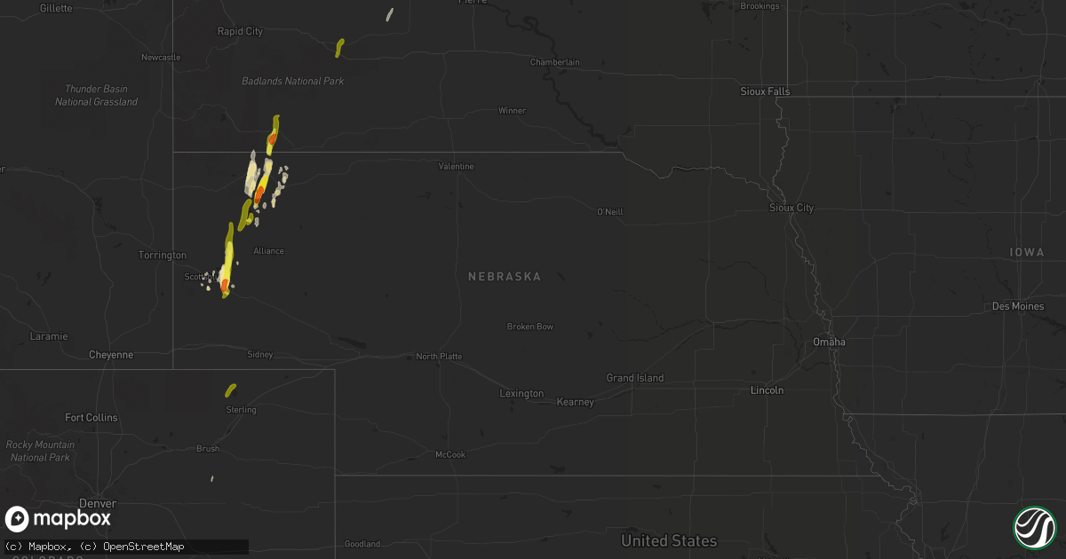
Hail Map in Nebraska on May 21, 2021
Get this storm
May 21 map
$229
one time, instant access
Download today. No call, no setup
Keep the $229
Bought the map and want the full workflow? Apply the entire $229 to a subscription within 7 days. None of it is wasted.
Every map, not just this one
This buys you this map. Subscription and you get every map we run, in the markets you choose from a few cities to whole states to nationwide. Plus real-time alerts the moment a storm fires.
Contact data
Name, contact info, occupancy, even credit band for addresses in the footprint. You go from where it hit to who to call.
Become the source they trust
Unlimited branding weather history reports on demand. You already have the documented answer ready for the property owner, and you are the one who showed up with it.
Property data and RoofTrace estimates
Pull up any address you have got, its value and the exact code rules for that jurisdiction, straight from One Click Code. Then RoofTrace estimates the squares, pitch, and roof value, priced the way you price.
Storm reports in Nebraska
Nebraska
| Date | Description |
|---|---|
| 05/21/20216:38 PM CDT | Many quarter size hail and a few golfball size. |
| 05/21/20216:35 PM CDT | At the job corps building. |
| 05/21/20216:30 PM CDT | Delayed report from media. |
| 05/21/202112:26 AM CDT | At 525 PM MDT, a severe thunderstorm was located near Moomaws Corner, or 14 miles east of Scottsbluff, moving north at 45 mph. HAZARD...Golf ball size hail and 60 mph wind gusts. SOURCE...Radar indicated. IMPACT...People and animals outdoors will be injured. Expect hail damage to roofs, siding, windows, and vehicles. Expect wind damage to roofs, siding, and trees. Locations impacted include... Bayard, Minatare, Kilpatrick Lake, Lake Minatare Campground, Flahertys Corner, Moomaws Corner, Lake Minatare, South Bayard Junction and McGrew. |
All States Impacted by Hail Map on May 21, 2021
Cities Impacted by Hail Map on May 21, 2021
- Minatare, NE
- Bayard, NE
- Hemingford, NE
- Oelrichs, SD
- Whitney, NE
- Chadron, NE
- Mcgrew, NE
- Alliance, NE
- Hay Springs, NE
- Pine Ridge, SD
- Gering, NE
- Tucumcari, NM
- Elida, NM
- Woodrow, CO
- Lamar, CO
- Marsland, NE
- Midland, SD
- Scottsbluff, NE
- Mosquero, NM
- San Jon, NM
- Hugo, CO
- Las Animas, CO
- Kadoka, SD
- Quinn, SD
- Harrisburg, NE
- Nara Visa, NM
- Logan, NM
- Portales, NM
- Clovis, NM
- Mcalister, NM
- Amistad, NM
- Padroni, CO
- Sterling, CO
- Karval, CO
- Arlington, CO
- Sugar City, CO


