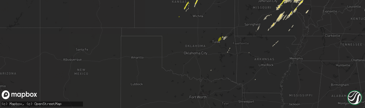
Hail Map in Oklahoma on May 21, 2019
The weather event in Oklahoma on May 21, 2019 includes Hail map. 7 states and 296 cities were impacted and suffered possible damage. The total estimated number of properties impacted is 10,841.
Want more than just the map?
Turn this storm into a full workflow.
- Owner + property data so you know who to knock
- OnDemand branded weather history reports to win the "did we even have hail?" argument
- RoofTrace estimate so reps stop guessing numbers at the door
Bought this map? Upgrade within 7 days and we'll credit the $230. (10-15 min setup call)
Hail
10,841
Estimated number of impacted properties by a 1.00" hail or larger0
Estimated number of impacted properties by a 1.75" hail or larger0
Estimated number of impacted properties by a 2.50" hail or largerStorm reports in Oklahoma
Oklahoma
| Date | Description |
|---|---|
| 05/21/20197:10 AM CDT | A local report indicates 1.00 inch wind near 2 WSW FOYIL |
| 05/21/20197:05 AM CDT | Spotter reports 1 inch hail north of claremore near highway 88 and 420 rd. |
| 05/21/20197:00 AM CDT | Possible tornado damage around wilson |
| 05/21/20194:54 AM CDT | At 954 AM CDT, severe thunderstorms were located along a line extending from South West City to near Gravette to near Gentry, moving northeast at 45 mph. HAZARD...60 mph wind gusts and nickel size hail. SOURCE...Radar indicated. IMPACT...Expect damage to roofs, siding, and trees. Locations impacted include... Big Sugar Creek State Park... Anderson... Noel... Goodman... South West City... Pineville... Wheaton... Lanagan... Fairview... Stella... Powell... Rocky Comfort...This includes Interstate 49 between mile markers 1 and 13. |
| 05/21/20191:00 AM CDT | At 600 AM CDT, severe thunderstorms were located along a line extending from 3 miles southwest of Keystone State Park to Mounds to 6 miles northwest of Pharoah, moving northeast at 60 mph. HAZARD...60 mph wind gusts and nickel size hail. SOURCE...Radar indicated. IMPACT...Expect damage to roofs, siding, and trees. Locations in or near the path include... Tulsa... Broken Arrow... Sand Springs... Claremore... Okmulgee... Owasso... Bixby... Sapulpa... Jenks... Glenpool... Coweta... Skiatook... Catoosa... Collinsville... Verdigris... Mannford... Haskell... Inola... Kiefer... Morris...This includes Interstate 44 between mile markers 202 and 264. |
| 05/21/201912:24 AM CDT | At 524 AM CDT, severe thunderstorms were located along a line extending from 5 miles east of Shamrock to 6 miles south of Bristow to 6 miles east of Seminole, moving east at 40 mph. HAZARD...60 mph wind gusts. SOURCE...Radar indicated. IMPACT...Expect damage to roofs, siding, and trees. Locations in or near the path include... Tulsa... Bristow... Okemah... Sapulpa... Jenks... Okfuskee... Glenpool... Kiefer... Beggs... Boley... Mounds... Kellyville... Weleetka... Depew... Paden... Bearden... Slick... Castle... Shamrock... Clearview...This includes the following highways, Interstate 40 in Oklahoma between mile markers 212 and 232. Interstate 44 between mile markers 180 and 217. |
| 05/20/201911:59 PM CDT | At 458 AM CDT, severe thunderstorms were located along a line extending from 3 miles southwest of Kendrick to 4 miles southeast of Davenport to 2 miles southeast of Konawa, moving northeast at 40 mph. HAZARD...60 mph wind gusts and quarter size hail. SOURCE...Radar indicated. IMPACT...Hail damage to vehicles is expected. Expect wind damage to roofs, siding, and trees. Locations in or near the path include... Bristow... Drumright... Boley... Oilton... Depew... Paden... Bearden... Castle... Shamrock... Welty... Silver City... Milfay... Mason... This includes the following highways, Interstate 40 in Oklahoma between mile markers 212 and 219. Interstate 44 between mile markers 178 and 191. |
| 05/20/201911:45 PM CDT | At 444 AM CDT, the leading edge of a line of severe thunderstorms were located from 4 miles south of Sparks to 3 miles north of St. Louis, moving east-northeast at 50 mph. HAZARD...70 mph wind gusts. SOURCE...Radar indicated. IMPACT...Expect considerable tree damage. Damage is likely to mobile homes, roofs, and outbuildings. Locations impacted include... Shawnee, Seminole, Tecumseh, McLoud, Stroud, Prague, Meeker, Maud, Davenport, Earlsboro, Bowlegs, Tribbey, Cromwell, Johnson, Sparks, St. Louis, Brooksville, Macomb, Dale and Little. |
| 05/20/201911:24 PM CDT | At 423 AM CDT, severe thunderstorms were located along a line extending from southeast Oklahoma City about 5 miles west of Newalla to near Pink, moving northeast at 30 mph. HAZARD...70 mph wind gusts. SOURCE...Radar indicated. IMPACT...Expect considerable tree damage. Damage is likely to mobile homes, roofs, and outbuildings. Locations impacted include... Southeastern Oklahoma City, northeastern Norman, Shawnee, Tecumseh, Choctaw, Harrah, McLoud, Pink, Luther, Meeker, Wellston, Johnson, Warwick, Fallis, Stella, Dale, Newalla, Bethel Acres and Aydelotte. |
| 05/20/201910:47 PM CDT | At 346 AM CDT, a severe thunderstorm was located 3 miles southwest of Noble, moving northeast at 35 mph. HAZARD...70 mph wind gusts. SOURCE...Radar indicated. IMPACT...Expect considerable tree damage. Damage is likely to mobile homes, roofs, and outbuildings. Locations impacted include... Southeastern Oklahoma City, Norman, Noble, Slaughterville, Goldsby, Stella, Lake Thunderbird and Little Axe. |
| 05/20/20199:27 PM CDT | At 227 AM CDT, severe thunderstorms were located along a line extending from 10 miles west of Duncan to near Waurika Lake, moving east at 55 mph. HAZARD...70 mph wind gusts and quarter size hail. SOURCE...Radar indicated. IMPACT...Hail damage to vehicles is expected. Expect considerable tree damage. Wind damage is also likely to mobile homes, roofs, and outbuildings. Locations impacted include... Duncan, Marlow, Comanche, Bray, Velma, Hastings, Loco, Addington, Waurika Lake, Corum, Central High, Empire City and Cox City. |
| 05/20/20198:38 PM CDT | At 138 AM CDT, a severe thunderstorm was located 3 miles northwest of Slick, moving northeast at 25 mph. HAZARD...60 mph wind gusts. SOURCE...Radar indicated. IMPACT...Expect damage to roofs, siding, and trees. Locations in or near the path include... Bristow... Sapulpa... Kiefer... Mounds... Kellyville... Slick...This includes Interstate 44 between mile markers 190 and 205, andbetween mile markers 208 and 213. |
| 05/20/20198:03 PM CDT | At 103 AM CDT, the leading edge of a line of severe thunderstorms was located from 7 miles southeast of Thalia to 4 miles east of Seymour, moving northeast at 60 mph. HAZARD...Ping pong ball size hail and 60 mph wind gusts. SOURCE...Radar indicated. IMPACT...People and animals outdoors will be injured. Expect hail damage to roofs, siding, windows, and vehicles. Expect wind damage to roofs, siding, and trees. Locations impacted include... Wichita Falls, Burkburnett, Seymour, Iowa Park, Electra, Holliday, Grandfield, Davidson, Hollister, Loveland, Sheppard AFB, Lake Diversion, Dundee, Harrold, Lake Kemp, Mabelle, Oklaunion, Mankins, Lake Kickapoo and Grayback. |
Cities Impacted by Hail Map on May 21, 2019
- Bunker Hill, KS
- Lakewood, IL
- Cowden, IL
- Beecher City, IL
- Shelbyville, IL
- Junction City, KS
- Abilene, KS
- Enterprise, KS
- Chapman, KS
- Red Bud, IL
- Sainte Genevieve, MO
- Evansville, IL
- Bloomsdale, MO
- Prairie Du Rocher, IL
- Galva, KS
- Gypsum, KS
- Canton, KS
- Roxbury, KS
- Corning, IA
- Strasburg, IL
- Vermillion, KS
- Axtell, KS
- Baileyville, KS
- Adair, OK
- Big Cabin, OK
- Collinsville, IL
- Granite City, IL
- East Saint Louis, IL
- Caseyville, IL
- O'Fallon, IL
- Mulkeytown, IL
- Du Quoin, IL
- Elkville, IL
- Vergennes, IL
- Dowell, IL
- Washington, MO
- Augusta, MO
- Marthasville, MO
- Batesville, AR
- Westmoreland, KS
- Lyons, KS
- Claremore, OK
- Chelsea, OK
- Ramsey, IL
- Westboro, MO
- Fairfax, MO
- Tarkio, MO
- New Baden, IL
- Victoria, KS
- Fort Dodge, IA
- Otho, IA
- Badger, IA
- Oldfield, MO
- Seymour, MO
- Ava, MO
- Doe Run, MO
- Bonne Terre, MO
- Farmington, MO
- Park Hills, MO
- Mascoutah, IL
- Albers, IL
- Germantown, IL
- New Douglas, IL
- Hillsboro, IL
- Highland, IL
- Pocahontas, IL
- Marine, IL
- Donnellson, IL
- Sorento, IL
- Coffeen, IL
- Saint Jacob, IL
- Greenville, IL
- Salina, KS
- De Soto, IL
- Sesser, IL
- Murphysboro, IL
- Delia, KS
- Rossville, KS
- Blanchard, IA
- Saint Charles, MO
- Saint Peters, MO
- Villisca, IA
- Nodaway, IA
- Lindsborg, KS
- Belleville, IL
- Little River, KS
- Brownstown, IL
- Vandalia, IL
- Smithboro, IL
- Keyesport, IL
- Fillmore, IL
- Mulberry Grove, IL
- Boss, MO
- Steelville, MO
- Bixby, MO
- Salem, MO
- Davisville, MO
- Potosi, MO
- Bunker, MO
- Viburnum, MO
- Hutchinson, KS
- Nickerson, KS
- Bingham, IL
- Plevna, KS
- Sterling, KS
- Alden, KS
- Wappapello, MO
- Glenallen, MO
- Gipsy, MO
- Greenville, MO
- Lowndes, MO
- Troy, IL
- Lebanon, IL
- Seneca, KS
- Saint Ann, MO
- Labadie, MO
- Villa Ridge, MO
- O'Fallon, MO
- Beaufort, MO
- Sullivan, MO
- Defiance, MO
- Saint Louis, MO
- Wildwood, MO
- Union, MO
- Gray Summit, MO
- Eureka, MO
- Lake Saint Louis, MO
- Saint James, MO
- Florissant, MO
- Foristell, MO
- Rosebud, MO
- Earth City, MO
- Maryland Heights, MO
- Saint Albans, MO
- Leslie, MO
- Ballwin, MO
- Cuba, MO
- Wentzville, MO
- Hazelwood, MO
- Leasburg, MO
- Owensville, MO
- Pacific, MO
- Bourbon, MO
- Bridgeton, MO
- Chesterfield, MO
- Gerald, MO
- Hiawatha, KS
- Clarinda, IA
- Dow, IL
- Elsah, IL
- Godfrey, IL
- Fairview Heights, IL
- Alhambra, IL
- Olsburg, KS
- Manhattan, KS
- French Village, MO
- Ironton, MO
- Bismarck, MO
- Solomon, KS
- Edwardsville, IL
- Glen Carbon, IL
- Alton, IL
- West Alton, MO
- Conway, AR
- Gowrie, IA
- Dora, MO
- West Plains, MO
- Willow Springs, MO
- Taneyville, MO
- Tower Hill, IL
- Oconee, IL
- Ellis, KS
- Hays, KS
- Clay Center, KS
- Fort Leonard Wood, MO
- Newburg, MO
- Gurdon, AR
- Worden, IL
- Lesterville, MO
- Black, MO
- Centerville, MO
- Caledonia, MO
- Belleview, MO
- Hamel, IL
- Trenton, IL
- Maryville, IL
- Madison, IL
- Saint Clair, MO
- Onaga, KS
- Riley, KS
- Leonardville, KS
- Abbyville, KS
- Poplar Bluff, MO
- Williamsville, MO
- Highland, KS
- Robinson, KS
- Yukon, MO
- Elk Creek, MO
- Hartshorn, MO
- Eunice, MO
- Eminence, MO
- Mountain View, MO
- Summersville, MO
- Vinita, OK
- Claflin, KS
- Fenton, MO
- Edgar Springs, MO
- Stanton, IA
- Duncombe, IA
- Bartelso, IL
- Freeburg, IL
- Aviston, IL
- New Athens, IL
- Okawville, IL
- Clarksville, AR
- Marissa, IL
- Addieville, IL
- Lenzburg, IL
- Breese, IL
- Shenandoah, IA
- Northboro, IA
- Coin, IA
- Essex, IA
- Park Hill, OK
- Milford, KS
- Sidney, AR
- Cave City, AR
- Venice, IL
- Shobonier, IL
- Nokomis, IL
- Carlyle, IL
- Lovejoy, IL
- Witt, IL
- Dupo, IL
- Vernon, IL
- Herrick, IL
- Columbia, IL
- Irving, IL
- East Carondelet, IL
- Patoka, IL
- Summerfield, IL
- Millstadt, IL
- Atoka, OK
- Mayetta, KS
- Auburn, NE
- Jadwin, MO
- Brownville, NE
- Falcon, MO
- Lynchburg, MO
- Laquey, MO
- Waynesville, MO
- Oregon, MO
- Maitland, MO
- New Cambria, KS
- Russell, KS
- Humboldt, NE
- Dawson, NE
- Nemaha, NE
- Stella, NE
- Mcpherson, KS
- Moundridge, KS
- Pilot Knob, MO
- Middle Brook, MO
- Arcadia, MO
- Modoc, IL
- Oakland, IA
- Carson, IA
- Macedonia, IA
- Williford, AR
- Evening Shade, AR
- Poughkeepsie, AR
- Bern, KS
- Corning, KS
- Oneida, KS
- Centralia, KS
- Pryor, OK
- Webbers Falls, OK
- Gore, OK
- Tulsa, OK
- Owasso, OK
- Catoosa, OK
- Collinsville, OK
- Geneseo, KS
- Wakefield, KS
- Randolph, KS
- Bennington, KS
- Holton, KS
- Denison, KS
- Topeka, KS
- Meriden, KS
- Hoyt, KS
- Whiting, KS
- Netawaka, KS
- Peru, NE
- Watson, MO
- Pratt, KS


