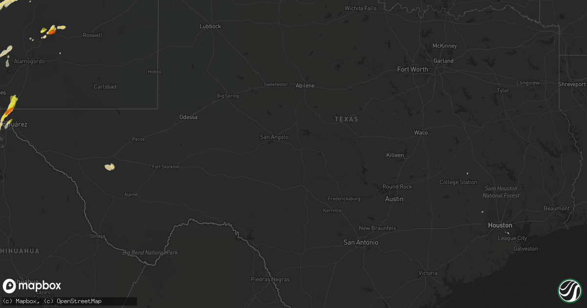
Hail Map in Texas on May 21, 2018
Get this storm
May 21 map
$229
one time, instant access
Download today. No call, no setup
Keep the $229
Bought the map and want the full workflow? Apply the entire $229 to a subscription within 7 days. None of it is wasted.
Every map, not just this one
This buys you this map. Subscription and you get every map we run, in the markets you choose from a few cities to whole states to nationwide. Plus real-time alerts the moment a storm fires.
Contact data
Name, contact info, occupancy, even credit band for addresses in the footprint. You go from where it hit to who to call.
Become the source they trust
Unlimited branding weather history reports on demand. You already have the documented answer ready for the property owner, and you are the one who showed up with it.
Property data and RoofTrace estimates
Pull up any address you have got, its value and the exact code rules for that jurisdiction, straight from One Click Code. Then RoofTrace estimates the squares, pitch, and roof value, priced the way you price.
Storm reports in Texas
Texas
| Date | Description |
|---|---|
| 05/21/20181:16 AM CDT | At 615 PM MDT, severe thunderstorms continued over the El Paso area, moving northeast at 30 mph. HAZARD...Ping pong ball size hail and 60 mph wind gusts. SOURCE...Trained weather spotters. IMPACT...People and animals outdoors will be injured. Expect hail damage to roofs, siding, windows, and vehicles. Expect wind damage to roofs, siding, and trees. Locations impacted include... Central El Paso... Chaparral... East El Paso... West El Paso... Mcgregor Range Base... Northeast El Paso... El Paso... Anthony Gap... Fort Bliss... Montana Vista... Westway... and Franklin Mountains State Park. |
| 05/21/201812:42 AM CDT | At 542 PM MDT, a severe thunderstorm was located 7 miles south of Central El Paso, moving northeast at 30 mph. HAZARD...60 mph wind gusts and half dollar size hail. SOURCE...Radar indicated. IMPACT...Hail damage to vehicles is expected. Expect wind damage to roofs, siding, and trees. Locations impacted include... Sunland Park... Mission Valley... Central El Paso... East El Paso... West El Paso... Northeast El Paso... El Paso... Socorro... Vinton... Westway... Fort Bliss... Santa Teresa... Sparks... Canutillo... La Union... and Franklin Mountains State Park. |
| 05/20/20187:29 PM CDT | A local report indicates 1.50 inch wind near NORTHEAST EL PASO |
| 05/20/20187:20 PM CDT | A local report indicates 1.50 inch wind near NORTHEAST EL PASO |
| 05/20/20187:13 PM CDT | A local report indicates 2.00 inch wind near 2 S NORTHEAST EL PASO |
| 05/20/20187:13 PM CDT | A local report indicates 62 MPH wind near 2 S NORTHEAST EL PASO |
| 05/20/20187:11 PM CDT | A local report indicates 1.00 inch wind near NORTHEAST EL PASO |
| 05/20/20187:05 PM CDT | A local report indicates 1.00 inch wind near EAST EL PASO |
| 05/20/20187:05 PM CDT | Several trees down near sunland park mall. Time estimated based on nearby gust report. |
All States Impacted by Hail Map on May 21, 2018
Cities Impacted by Hail Map on May 21, 2018
- Tijeras, NM
- Datil, NM
- Bernalillo, NM
- Douglas, WY
- Wheatland, WY
- Chugwater, WY
- Marion, OH
- Morral, OH
- Plain City, OH
- Marysville, OH
- Ostrander, OH
- Edgewood, NM
- Walton, WV
- Elkview, WV
- Charleston, WV
- Mountainair, NM
- Willard, NM
- Bloomingburg, OH
- Mount Sterling, OH
- Washington Court House, OH
- Star City, AR
- Bosque, NM
- Belen, NM
- Veguita, NM
- Oxford, NC
- House, NM
- Melrose, NM
- Floyd, NM
- Marietta, OH
- Vienna, WV
- Williamstown, WV
- Sunland Park, NM
- Fort Bliss, TX
- Chaparral, NM
- Santa Teresa, NM
- El Paso, TX
- Cloudcroft, NM
- Brusett, MT
- Cheyenne, WY
- Capitan, NM
- Newport, OH
- Rio Rancho, NM
- Jackson, MS
- Byram, MS
- Guernsey, WY
- Magdalena, NM
- Martell, NE
- Boonville, IN
- Tennyson, IN
- Fe Warren Afb, WY
- Big Timber, MT
- Columbus, MT
- Coila, MS
- Galion, OH
- Mansfield, OH
- Canton, MS
- Cubero, NM
- Casa Blanca, NM
- Orient, OH
- London, OH
- Gillette, WY
- Millfield, OH
- Franklin, IN
- Needham, IN
- Shelbyville, IN
- Cuervo, NM
- Musselshell, MT
- Socorro, NM
- Claunch, NM
- Rohwer, AR
- Arkansas City, AR
- Brandon, MS
- Encino, NM
- Kingsland, AR
- Ivan, AR
- Park Hills, MO
- Clarksburg, OH
- Williamsport, OH
- New Holland, OH
- Warrenton, NC
- Tinnie, NM
- Mescalero, NM
- Laguna, NM
- Athens, OH
- Nelsonville, OH
- Bardstown, KY
- Utica, MS
- Raymond, MS
- Spencer, WV
- Lincoln, NM
- South Solon, OH
- Jeffersonville, OH
- Butler, OH
- Perrysville, OH
- Moriarty, NM
- Iola, TX
- Roundup, MT
- Milan, NM
- Grants, NM
- Pine Bluff, AR
- Grady, AR
- Flowood, MS
- Lavina, MT
- Greenup, KY
- Argillite, KY
- Grayson, KY
- Caledonia, OH
- Lena, MS
- Conchas Dam, NM
- Wayne, NE
- Corona, NM
- Nogal, NM
- Alto, NM
- Taiban, NM
- New Bloomington, OH
- Edison, OH
- Bennett, CO
- Deer Trail, CO
- Agate, CO
- Orchard, NE
- Grove City, OH
- Mayhill, NM
- Ruidoso, NM
- Ruidoso Downs, NM
- Mechanicsburg, OH
- Woodstock, OH
- Kim, CO
- Custer, MT
- Fort Davis, TX
- Valentine, TX
- Milford Center, OH
- Irwin, OH
- Placitas, NM
- Algodones, NM
- Martinsville, IN
- Cypress, TX
- Raton, NM
- Albuquerque, NM
- Truth Or Consequences, NM
- Rison, AR
- Zachary, LA
- Baker, LA
- Orchard, CO
- Belpre, OH
- Fleming, OH
- Vincent, OH
- Stewart, OH
- Cutler, OH
- Princeton, KY
- Lynnville, IN
- Rapelje, MT
- Glenmont, OH
- Loudonville, OH
- Houston, TX
- Bluewater, NM
- Crete, NE
- Hallam, NE
- Briggsdale, CO
- West Jefferson, OH
- Worden, MT
- Judith Gap, MT
- Plainview, NE
- Stanley, NM
- Solano, NM
- Columbus, IN
- Estancia, NM
- Raymond, OH
- Gandeeville, WV
- Springfield, KY
- Oakland City, IN
- Fort Branch, IN
- Elberfeld, IN
- Fort Sumner, NM
- Bancroft, NE
- Creedmoor, NC
- Altheimer, AR
- Amesville, OH
- Newkirk, NM
- Ada, OH
- Harrod, OH
- Benoit, MS
- Greenville, OH
- Roberts, MT
- Webster, TX
- Elko, NV
- Glencoe, NM
- McArthur, OH
- New Marshfield, OH
- Dola, OH
- Pueblo Of Acoma, NM
- Wright, WY
- Lakeville, OH
- Big Prairie, OH
- Osmond, NE
- La Mesa, NM
- Kirtland Afb, NM
- Farmington, MO
- Kersey, CO
- Weldona, CO
- Yoder, WY
- Hondo, NM
- San Patricio, NM
- Las Cruces, NM
- Bloomfield, IN
- Lyons, IN
- Morgantown, IN
- Bargersville, IN
- Delaware, OH


