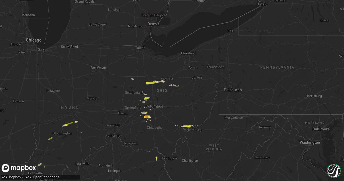
Hail Map in Ohio on May 21, 2018
Get this storm
May 21 map
$229
one time, instant access
Download today. No call, no setup
Keep the $229
Bought the map and want the full workflow? Apply the entire $229 to a subscription within 7 days. None of it is wasted.
Every map, not just this one
This buys you this map. Subscription and you get every map we run, in the markets you choose from a few cities to whole states to nationwide. Plus real-time alerts the moment a storm fires.
Contact data
Name, contact info, occupancy, even credit band for addresses in the footprint. You go from where it hit to who to call.
Become the source they trust
Unlimited branding weather history reports on demand. You already have the documented answer ready for the property owner, and you are the one who showed up with it.
Property data and RoofTrace estimates
Pull up any address you have got, its value and the exact code rules for that jurisdiction, straight from One Click Code. Then RoofTrace estimates the squares, pitch, and roof value, priced the way you price.
Storm reports in Ohio
Ohio
| Date | Description |
|---|---|
| 05/21/20186:36 PM CDT | Tree down on 3000 martell rd. |
| 05/21/20186:30 PM CDT | Trees down across 309 e |
| 05/21/20184:26 PM CDT | Power lines down. |
| 05/21/20182:30 PM CDT | Caller reported there wheel barrel piles of hail the size of quarters. |
| 05/21/20182:30 PM CDT | A tree down across one lane of veto road. |
| 05/21/20185:29 AM CDT | At 1029 PM EDT, a severe thunderstorm was located near Lynchburg, moving northeast at 40 mph. HAZARD...60 mph wind gusts and quarter size hail. SOURCE...Radar indicated. IMPACT...Minor hail damage to vehicles is possible. Expect wind damage to trees and power lines. Locations impacted include... Hillsboro, Greenfield, Lynchburg, Leesburg, Rocky Fork Point, Highland Holiday, Russell, New Market, Good Hope, Mowrystown, Highland, South Salem, East Monroe, Danville in Highland County, Samantha, Rock Mills, State Route 136 at US Route 62, New Martinsburg, Highland County Airport and Rocky Fork Lake. |
| 05/21/20185:03 AM CDT | At 1003 PM EDT, a severe thunderstorm was located over Mount Orab, moving northeast at 40 mph. HAZARD...60 mph wind gusts. SOURCE...Radar indicated. IMPACT...Expect damage to trees and power lines. Locations impacted include... Mount Orab, Williamsburg, Lynchburg, Sardinia, Russell, New Market, Mowrystown, Fayetteville, St. Martin, Chasetown, Danville in Highland County, Greenbush, Buford, State Route 32 at US Route 68, New Hope, State Route 136 at US Route 62, Locust Ridge and Lake Lorelei. |
| 05/21/20184:15 AM CDT | At 914 PM EDT, severe thunderstorms were located along a line extending from near Delaware to Choctaw Lake, moving east at 30 mph. HAZARD...60 mph wind gusts and quarter size hail. SOURCE...Radar indicated. IMPACT...Minor hail damage to vehicles is possible. Expect wind damage to trees and power lines. Locations impacted include... Columbus, Dublin, Westerville, Delaware, Upper Arlington, Gahanna, Hilliard, Marysville, Worthington, London, Jefferson, Powell, Sunbury, Plain City, West Jefferson, Ashley, Minerva Park, Choctaw Lake, New California and Polaris.This includes the following Interstates... I-70 in Ohio between mile markers 67 and 101. I-71 in Ohio between mile markers 106 and 138. |
| 05/21/20183:48 AM CDT | At 847 PM EDT, a severe thunderstorm was located near New California, moving northeast at 10 mph. HAZARD...60 mph wind gusts and quarter size hail. SOURCE...Trained weather spotters reported quarter size hail. IMPACT...Minor hail damage to vehicles is possible. Expect wind damage to trees and power lines. Locations impacted include... Dublin, Delaware, Marysville, Powell, Sunbury, Ashley, New California, Radnor, Shawnee Hills, Ostrander, Magnetic Springs, Alum Creek State Park, Delaware State Park, Olive Green, US Route 33 at US Route 42, Warrensburg, Kilbourne, Columbus Zoo, Lewis Center and Interstate 71 at US Route 36/State Route 37.This includes I-71 in Ohio between mile markers 129 and 138. |
| 05/21/20183:39 AM CDT | At 838 PM EDT, a severe thunderstorm was located near Mount Sterling, moving north at 10 mph. HAZARD...60 mph wind gusts and half dollar size hail. SOURCE...Radar indicated. IMPACT...Minor hail damage to vehicles is possible. Expect wind damage to trees and power lines. Locations impacted include... Grove City, Ashville, Mount Sterling, South Bloomfield, Williamsport, Commercial Point, Fox, Harrisburg, Orient, Lockbourne, Darbyville, Deer Creek Lake, Derby, Duvall and Darbydale.This includes I-71 in Ohio between mile markers 88 and 97. |
| 05/21/20183:01 AM CDT | At 800 PM EDT, a severe thunderstorm was located near Mount Sterling, moving northeast at 15 mph. HAZARD...60 mph wind gusts and quarter size hail. SOURCE...Radar indicated. IMPACT...Minor hail damage to vehicles is possible. Expect wind damage to trees and power lines. Locations impacted include... Mount Sterling, Bloomingburg, New Holland, Commercial Point, Harrisburg, Orient, Deer Creek Lake, Chenoweth, Derby, Madison Mills, Big Plain, Wrightsville and Pancoastburg.This includes I-71 in Ohio between mile markers 79 and 93. |
| 05/21/20182:55 AM CDT | At 755 PM EDT, a severe thunderstorm was located near Richwood, moving east at 35 mph. HAZARD...60 mph wind gusts. SOURCE...Radar indicated. IMPACT...Expect damage to trees and power lines. Locations impacted include... Delaware, Richwood, Ashley, Radnor, Magnetic Springs, Raymond, Delaware State Park, Byhalia, Broadway, Warrensburg, Pharisburg, Somersville, Leonardsburg, Kilbourne and Essex.This includes I-71 in Ohio between mile markers 136 and 138. |
| 05/21/20182:54 AM CDT | At 754 PM EDT, severe thunderstorms were located along a line extending from near Crestline to 7 miles south of Galion to near Mount Gilead, moving east at 25 mph. HAZARD...60 mph wind gusts and quarter size hail. SOURCE...Radar indicated. IMPACT...Minor damage to vehicles is possible. Expect damage to trees and power lines. Locations impacted include... Mansfield, Galion, Ontario, Lexington, Crestline, Bellville, Butler, Lucas, Iberia and Shauck. |
| 05/21/20181:53 AM CDT | At 652 PM EDT, a severe thunderstorm was located near Morral, or near Marion, moving east at 20 mph. HAZARD...60 mph wind gusts and quarter size hail. SOURCE...Radar indicated. IMPACT...Minor damage to vehicles is possible. Expect damage to trees and power lines. Locations impacted include... Marion, Bucyrus, Upper Sandusky, La Rue, Morral, Marseilles, Carey, Benton, Nevada, Caledonia, New Bloomington, North Robinson, Harpster, Oceola and Sulpher Springs. |
| 05/21/20181:25 AM CDT | At 625 PM EDT, a severe thunderstorm was located over Oldtown, or 8 miles north of Grayson, moving north at 15 mph. HAZARD...60 mph wind gusts and quarter size hail. SOURCE...Radar indicated. IMPACT...Hail damage to vehicles is expected. Expect wind damage to roofs, siding, and trees. Locations impacted include... Greenup, Greenbo Lake, Oldtown, Franklin Furnace, Flatwoods, Raceland, Worthington, Wurtland and Hanging Rock. |
| 05/20/20189:45 PM CDT | Large limbs downed. Some debris on roadway. |
| 05/20/20189:35 PM CDT | Tree down. |
| 05/20/20189:28 PM CDT | Trees downed. |
| 05/20/20189:04 PM CDT | Large limbs downed. Some debris on roadway. |
| 05/20/20189:04 PM CDT | A brief and weak tornado touched down causing mainly tree and some minor structural damage along its 1.8 mile path north of mt. Orab. |
| 05/20/20188:20 PM CDT | A local report indicates 1.00 inch wind near 4 NNE PLAIN CITY |
| 05/20/20187:46 PM CDT | A local report indicates 1.00 inch wind near 2 SE MARYSVILLE |
| 05/20/20187:28 PM CDT | Trees and powerlines down in lexington area with 45-50 mph winds. 1000+ customers without power and 2 inches of rainfall on 820 lexington |
| 05/20/20187:20 PM CDT | A local report indicates 1.50 inch wind near MOUNT STERLING |
| 05/20/20187:15 PM CDT | Branches onto powerlines... Lines on fire on lexington and ontario rd. Trees also down on graham rd. And marton ave. |
All States Impacted by Hail Map on May 21, 2018
Cities Impacted by Hail Map on May 21, 2018
- Tijeras, NM
- Datil, NM
- Bernalillo, NM
- Douglas, WY
- Wheatland, WY
- Chugwater, WY
- Marion, OH
- Morral, OH
- Plain City, OH
- Marysville, OH
- Ostrander, OH
- Edgewood, NM
- Walton, WV
- Elkview, WV
- Charleston, WV
- Mountainair, NM
- Willard, NM
- Bloomingburg, OH
- Mount Sterling, OH
- Washington Court House, OH
- Star City, AR
- Bosque, NM
- Belen, NM
- Veguita, NM
- Oxford, NC
- House, NM
- Melrose, NM
- Floyd, NM
- Marietta, OH
- Vienna, WV
- Williamstown, WV
- Sunland Park, NM
- Fort Bliss, TX
- Chaparral, NM
- Santa Teresa, NM
- El Paso, TX
- Cloudcroft, NM
- Brusett, MT
- Cheyenne, WY
- Capitan, NM
- Newport, OH
- Rio Rancho, NM
- Jackson, MS
- Byram, MS
- Guernsey, WY
- Magdalena, NM
- Martell, NE
- Boonville, IN
- Tennyson, IN
- Fe Warren Afb, WY
- Big Timber, MT
- Columbus, MT
- Coila, MS
- Galion, OH
- Mansfield, OH
- Canton, MS
- Cubero, NM
- Casa Blanca, NM
- Orient, OH
- London, OH
- Gillette, WY
- Millfield, OH
- Franklin, IN
- Needham, IN
- Shelbyville, IN
- Cuervo, NM
- Musselshell, MT
- Socorro, NM
- Claunch, NM
- Rohwer, AR
- Arkansas City, AR
- Brandon, MS
- Encino, NM
- Kingsland, AR
- Ivan, AR
- Park Hills, MO
- Clarksburg, OH
- Williamsport, OH
- New Holland, OH
- Warrenton, NC
- Tinnie, NM
- Mescalero, NM
- Laguna, NM
- Athens, OH
- Nelsonville, OH
- Bardstown, KY
- Utica, MS
- Raymond, MS
- Spencer, WV
- Lincoln, NM
- South Solon, OH
- Jeffersonville, OH
- Butler, OH
- Perrysville, OH
- Moriarty, NM
- Iola, TX
- Roundup, MT
- Milan, NM
- Grants, NM
- Pine Bluff, AR
- Grady, AR
- Flowood, MS
- Lavina, MT
- Greenup, KY
- Argillite, KY
- Grayson, KY
- Caledonia, OH
- Lena, MS
- Conchas Dam, NM
- Wayne, NE
- Corona, NM
- Nogal, NM
- Alto, NM
- Taiban, NM
- New Bloomington, OH
- Edison, OH
- Bennett, CO
- Deer Trail, CO
- Agate, CO
- Orchard, NE
- Grove City, OH
- Mayhill, NM
- Ruidoso, NM
- Ruidoso Downs, NM
- Mechanicsburg, OH
- Woodstock, OH
- Kim, CO
- Custer, MT
- Fort Davis, TX
- Valentine, TX
- Milford Center, OH
- Irwin, OH
- Placitas, NM
- Algodones, NM
- Martinsville, IN
- Cypress, TX
- Raton, NM
- Albuquerque, NM
- Truth Or Consequences, NM
- Rison, AR
- Zachary, LA
- Baker, LA
- Orchard, CO
- Belpre, OH
- Fleming, OH
- Vincent, OH
- Stewart, OH
- Cutler, OH
- Princeton, KY
- Lynnville, IN
- Rapelje, MT
- Glenmont, OH
- Loudonville, OH
- Houston, TX
- Bluewater, NM
- Crete, NE
- Hallam, NE
- Briggsdale, CO
- West Jefferson, OH
- Worden, MT
- Judith Gap, MT
- Plainview, NE
- Stanley, NM
- Solano, NM
- Columbus, IN
- Estancia, NM
- Raymond, OH
- Gandeeville, WV
- Springfield, KY
- Oakland City, IN
- Fort Branch, IN
- Elberfeld, IN
- Fort Sumner, NM
- Bancroft, NE
- Creedmoor, NC
- Altheimer, AR
- Amesville, OH
- Newkirk, NM
- Ada, OH
- Harrod, OH
- Benoit, MS
- Greenville, OH
- Roberts, MT
- Webster, TX
- Elko, NV
- Glencoe, NM
- McArthur, OH
- New Marshfield, OH
- Dola, OH
- Pueblo Of Acoma, NM
- Wright, WY
- Lakeville, OH
- Big Prairie, OH
- Osmond, NE
- La Mesa, NM
- Kirtland Afb, NM
- Farmington, MO
- Kersey, CO
- Weldona, CO
- Yoder, WY
- Hondo, NM
- San Patricio, NM
- Las Cruces, NM
- Bloomfield, IN
- Lyons, IN
- Morgantown, IN
- Bargersville, IN
- Delaware, OH


