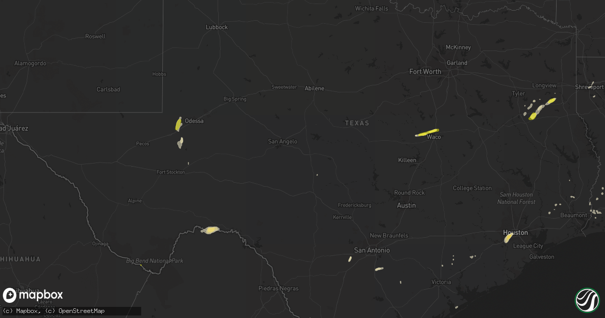
Hail Map in Texas on May 21, 2017
Get this storm
May 21 map
$229
one time, instant access
Download today. No call, no setup
Keep the $229
Bought the map and want the full workflow? Apply the entire $229 to a subscription within 7 days. None of it is wasted.
Every map, not just this one
This buys you this map. Subscription and you get every map we run, in the markets you choose from a few cities to whole states to nationwide. Plus real-time alerts the moment a storm fires.
Contact data
Name, contact info, occupancy, even credit band for addresses in the footprint. You go from where it hit to who to call.
Become the source they trust
Unlimited branding weather history reports on demand. You already have the documented answer ready for the property owner, and you are the one who showed up with it.
Property data and RoofTrace estimates
Pull up any address you have got, its value and the exact code rules for that jurisdiction, straight from One Click Code. Then RoofTrace estimates the squares, pitch, and roof value, priced the way you price.
Storm reports in Texas
Texas
| Date | Description |
|---|---|
| 05/21/20176:15 PM CDT | Public report via facebook stated quarter size hail in the city of zapata. |
| 05/21/20176:06 PM CDT | Employee at pepes grocery store in san ygnacio states customer reported hail the size of golf balls 5 miles nne of san ygnacio. |
| 05/21/20175:35 PM CDT | Spotternetwork.org reported tennis to baseball sized hail at 2235 utc 5/21/2017 |
| 05/21/20175:15 PM CDT | *** 1 fatal *** 14 year old boy was electrocuted after picking up live powerline that was downed in the storm |
| 05/21/20175:07 PM CDT | Ham operator reported 1 inch diameter hail at the laredo international airport at 2207 utc 5/21/2017 |
| 05/21/20175:05 PM CDT | 70 mph wind gust reported by spotternetwork.org. Event occurred at 2205 utc 5/21/2017. |
| 05/21/20175:01 PM CDT | Hail 2.50 inches in diameter reported by spotternetwork.org. Event occurred at 2201 utc 5/21/2017. |
| 05/21/20175:01 PM CDT | 70 mph wind gust reported by spotternetwork.org. Event occurred at 2201 utc 5/21/2017 |
| 05/21/20174:58 PM CDT | 60 mph wind gust reported by clyve herbert via spotternetwork.org. Event occurred at 2158 utc 5/21/2017. |
| 05/21/20174:57 PM CDT | 1.5 inch hail reported by alec scholten via spotternetwork.org. Event occurred at 2148 utc |
| 05/21/20174:55 PM CDT | 51 knot wind gust reported by the lrd asos at 2155 utc |
| 05/21/20174:51 PM CDT | Hail 1.75 inches in diameter reported by willoughby owen via spotternetwork.org. Event occurred 2151 utc. |
| 05/21/20174:45 PM CDT | Social media report of 1.50 inch hail in south central laredo |
| 05/21/20174:44 PM CDT | Roof damage at the laredo fire station |
| 05/21/20174:28 PM CDT | Damage survey in connection with severe thunderstorm on 5/21/2017 revealed straight-line wind damage along a narrow line around 6 miles in length approximately from the |
| 05/21/20178:35 AM CDT | A local report indicates 1.25 inch wind near CASTOLON |
| 05/21/20178:31 AM CDT | Delayed report: quarter size hail near lacy-lakeview |
| 05/21/20178:30 AM CDT | Quarter size hail reported off of hwy 308 near elm mott. |
| 05/21/20177:55 AM CDT | Quarter size hail reported near the intersection of fm 2490 and 1637 |
| 05/21/20177:45 AM CDT | Half dollar hail reported near china spring |
| 05/21/20177:25 AM CDT | Half dollar hail reported n of crawford |
| 05/21/20177:14 AM CDT | Quarter size hail reported at lake striker rv park restaurant and marina. |
| 05/21/20176:03 AM CDT | Damage locations along the joann street area included a construction company and nursery... With significant damage to an awning and metal roof. There were also downed |
| 05/21/20176:00 AM CDT | Large tree down blocking 5th street 2800 block |
| 05/20/20178:29 PM CDT | Starr county sheriffs department reports utility pole blown down by thunderstorm winds on luciano road in escobares. |
| 05/20/20178:05 PM CDT | Public reported half dollar size hail in fronton. |
| 05/20/20178:00 PM CDT | Public reported 3 to 4 trees blown down by thunderstorm winds in fronton. Also stated roof damage to house in fronton occurred on guerra street. |
| 05/20/20177:42 PM CDT | Spotter reports 70 mph winds 3 miles east of laredo |
All States Impacted by Hail Map on May 21, 2017
Cities Impacted by Hail Map on May 21, 2017
- Laredo, TX
- Leesville, LA
- Stafford, TX
- Bellaire, TX
- Sugar Land, TX
- Houston, TX
- Missouri City, TX
- El Campo, TX
- Port Allen, LA
- Overton, TX
- San Ygnacio, TX
- Shreveport, LA
- Liberty, MS
- Crawford, TX
- Benton, MS
- Bentonia, MS
- Jonesville, LA
- Ferriday, LA
- Springer, NM
- House, NM
- Cuervo, NM
- Dryden, TX
- Vaughan, MS
- Conchas Dam, NM
- Mosquero, NM
- Singer, LA
- Henderson, TX
- Jacksonville, TX
- Reklaw, TX
- Laneville, TX
- Crane, TX
- Zapata, TX
- Roma, TX
- Amory, MS
- Woodville, TX
- Floresville, TX
- Pleasanton, TX
- Nettleton, MS
- Gilbert, LA
- Bossier City, LA
- Starks, LA
- Lake Providence, LA
- Pioneer, LA
- Transylvania, LA
- Lorman, MS
- Fayette, MS
- Clayton, LA
- Port Gibson, MS
- Trementina, NM
- Wagon Mound, NM
- Sinton, TX
- Mirando City, TX
- Slaughter, LA
- Clinton, LA
- Pride, LA
- Zachary, LA
- Rio Grande City, TX
- Hull, TX
- Magnolia, AR
- Ragley, LA
- Goldsmith, TX
- Odessa, TX
- Natchez, MS
- Devine, TX
- Oilton, TX
- Waco, TX
- Elm Mott, TX
- Aberdeen, MS
- Okolona, MS
- Deridder, LA
- Sugartown, LA
- Seadrift, TX
- Monterey, LA
- Wharton, TX
- Baytown, TX
- Beckville, TX
- Pritchett, CO
- Mount Hope, AL
- Boise City, OK
- Greensburg, LA
- Magnolia, MS
- Kountze, TX
- Barksdale Afb, LA
- Sicily Island, LA
- Hallettsville, TX
- Tatum, TX
- Troup, TX
- Carthage, MS
- Harrisonburg, LA
- Vidalia, LA
- Longville, LA
- Woodway, TX
- Valley Mills, TX
- Saint Joseph, LA
- Hackberry, LA
- Eunice, LA
- Oakdale, LA
- China Spring, TX
- Pickens, MS
- Floyd, NM
- Ville Platte, LA
- Arnaudville, LA
- Kenton, OK
- Hebbronville, TX
- Vicksburg, MS
- Pattison, MS
- Abbeville, LA
- Lottie, LA
- Orange, TX
- Krotz Springs, LA
- Rosedale, LA
- Kenedy, TX
- Buna, TX
- Fort Stockton, TX
- Shannon, MS
- Sulphur, LA
- Vinton, LA
- Solano, NM
- Saratoga, TX
- Norwood, LA
- Saint Francisville, LA
- Breaux Bridge, LA
- Saint Martinville, LA
- Elmer, LA
- Hineston, LA
- Pineland, SC
- Heflin, LA
- Sibley, LA
- Dry Creek, LA
- Lake Charles, LA
- Silsbee, TX
- Ringgold, LA
- Jamestown, LA
- Edna, TX
- Tupelo, MS
- Philadelphia, MS
- Kosciusko, MS
- Yoakum, TX
- Menard, TX
- Union Church, MS
- Frierson, LA
- Sour Lake, TX
- Dequincy, LA
- Odem, TX
- Utica, MS
- Big Bend National Park, TX
- Las Vegas, NM
- Garita, NM
- Mcalister, NM
- Rusk, TX


