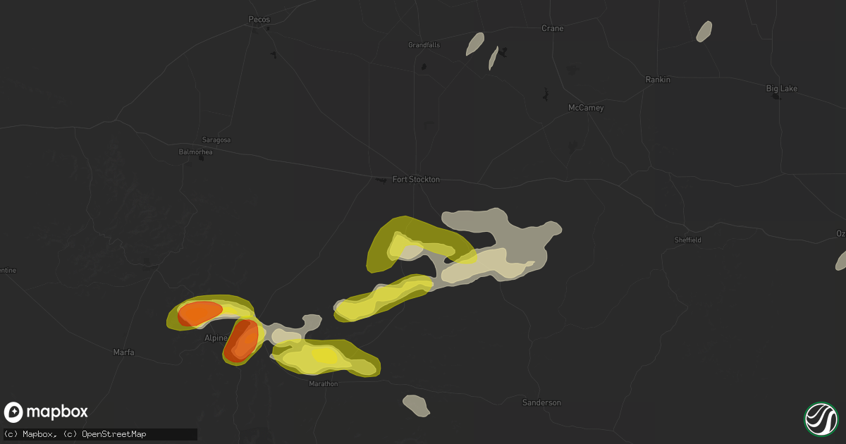
Hail Map in Fort Stockton, TX on May 20, 2026
Get this storm
May 20 map
$229
one time, instant access
Download today. No call, no setup
Keep the $229
Bought the map and want the full workflow? Apply the entire $229 to a subscription within 7 days. None of it is wasted.
Every map, not just this one
This buys you this map. Subscription and you get every map we run, in the markets you choose from a few cities to whole states to nationwide. Plus real-time alerts the moment a storm fires.
Contact data
Name, contact info, occupancy, even credit band for addresses in the footprint. You go from where it hit to who to call.
Become the source they trust
Unlimited branding weather history reports on demand. You already have the documented answer ready for the property owner, and you are the one who showed up with it.
Property data and RoofTrace estimates
Pull up any address you have got, its value and the exact code rules for that jurisdiction, straight from One Click Code. Then RoofTrace estimates the squares, pitch, and roof value, priced the way you price.
Storm reports in Fort Stockton, TX
Fort Stockton, TX
| Date | Description |
|---|---|
| 05/20/20265:48 PM CDT | Emergency manager reported quarter-sized hail 21-23 miles south/southeast of fort stockton along us 285. |
| 05/20/20265:00 PM CDT | Received a report of dime to quarter-sized hail about 15-20 miles south of fort stockton. The time of occurrence is partially estimated from radar. |
| 05/20/20264:58 PM CDT | Emergency manager reported quarter-sized hail 16 miles south of fort stockton on us 385. |
All States Impacted by Hail Map on May 20, 2026
All Cities Impacted by Hail Map on May 20, 2026
- Crane, TX
- Seminole, TX
- Seagraves, TX
- Warfordsburg, PA
- Needmore, PA
- Big Cove Tannery, PA
- Mercersburg, PA
- Midland, TX
- Andrews, TX
- Stanton, TX
- Lenorah, TX
- Tarzan, TX
- Goldsmith, TX
- Greencastle, PA
- Brownfield, TX
- Lebanon, TN
- Big Lake, TX
- Midkiff, TX
- Gordonsville, TN
- Carthage, TN
- Riddleton, TN
- Millerstown, PA
- Ickesburg, PA
- Gettysburg, PA
- Sandy Hook, KY
- West Liberty, KY
- Fort Valley, VA
- Knott, TX
- Gainesboro, TN
- Pleasant Shade, TN
- Big Spring, TX
- Menlo, GA
- Albany, KY
- Elkfork, KY
- Frederick, MD
- Whitleyville, TN
- Monticello, KY
- Wayne, WV
- Winchester, VA
- Alpha, KY
- White Post, VA
- Front Royal, VA
- Valley Head, AL
- Rising Fawn, GA
- Huntington, WV
- Prichard, WV
- Boyce, VA
- Celina, TN
- Tremont, PA
- Branchdale, PA
- Pottsville, PA
- Hegins, PA
- Linden, VA
- Union Bridge, MD
- Woodsboro, MD
- New Windsor, MD
- Lavalette, WV
- New Market, MD
- Walkersville, MD
- Round Hill, VA
- Mount Airy, MD
- Branchland, WV
- Barboursville, WV
- East Lynn, WV
- Markham, VA
- Delaplane, VA
- Upperville, VA
- Paris, VA
- Westminster, MD
- Hilham, TN
- Upperco, MD
- Fort Davis, TX
- Saint Albans, WV
- Poca, WV
- Nitro, WV
- Winfield, WV
- Scott Depot, WV
- Allons, TN
- Charleston, WV
- Alpine, TX
- Parkton, MD
- Reisterstown, MD
- Monroe, TN
- Livingston, TN
- Marathon, TX
- Scarsdale, NY
- White Plains, NY
- Hartsdale, NY
- Northport, NY
- Douglassville, PA
- Birdsboro, PA
- Oxford, PA
- Boyertown, PA
- Kennett Square, PA
- West Chester, PA
- Downingtown, PA
- Coatesville, PA
- Elkview, WV
- Cochranville, PA
- West Grove, PA
- Lincoln University, PA
- Pottstown, PA
- Gilbertsville, PA
- Rosedale, MD
- West Harrison, NY
- Purchase, NY
- Malvern, PA
- Immaculata, PA
- Baltimore, MD
- Clendenin, WV
- Schwenksville, PA
- Exton, PA
- Essex, MD
- Middle River, MD
- Cheyney, PA
- Thornton, PA
- Glen Mills, PA
- Kintnersville, PA
- Riegelsville, PA
- Landenberg, PA
- Avondale, PA
- Paoli, PA
- Berwyn, PA
- Fort Stockton, TX
- Procious, WV
- Amma, WV
- Bomont, WV
- Wallback, WV
- Newton, WV
- Centerport, NY
- Ivydale, WV
- Glenside, PA
- Chadds Ford, PA
- Nebo, WV
- Duck, WV
- Frametown, WV
- Blackwood, NJ
- Woodbury, NJ
- Wayne, PA
- Harleysville, PA
- Souderton, PA
- Telford, PA
- Collegeville, PA
- Oreland, PA
- Flourtown, PA
- Philadelphia, PA
- Staten Island, NY
- Sutton, WV
- Brooklyn, NY
- Myakka City, FL
- Rockford, AL
- Sylacauga, AL
- Forked River, NJ
- Goodwater, AL
- Parrish, FL
- Wimauma, FL
- Lithia, FL
- Riverview, FL
- Glasgow, VA
- Buena Vista, VA
- Lexington, VA
- Ozona, TX
- Menard, TX
- Trinidad, CO
- Eldorado, TX
- Sonora, TX
- Estillfork, AL
- Model, CO
- Brady, TX
- Chapmanville, WV
- Hext, TX
- Fort McKavett, TX
- Junction, TX
- London, TX
- Hebbronville, TX
- Laredo, TX
- Mason, TX
- Bruni, TX
- Zapata, TX
- Roma, TX
- Rio Grande City, TX
- Realitos, TX
- Concepcion, TX
- Benavides, TX
- Uvalde, TX
- Alice, TX
- Premont, TX
- Camp Wood, TX
- Barksdale, TX
- Leakey, TX
- Roanoke, VA
- Richboro, PA
- Jamison, PA
- Lawrence Township, NJ
- Warminster, PA
- New Hope, PA
- Titusville, NJ
- Morrisville, PA
- Doylestown, PA
- Trenton, NJ
- Newtown, PA
- Chalfont, PA
- Washington Crossing, PA
- Pennington, NJ
- Warrington, PA
- Furlong, PA
- Holmdel, NJ
- Hazlet, NJ
- Parlin, NJ
- Cliffwood, NJ
- Port Monmouth, NJ
- South Amboy, NJ
- Matawan, NJ
- Keansburg, NJ
- Sayreville, NJ
- Keyport, NJ
- Belford, NJ
- Middletown, NJ


