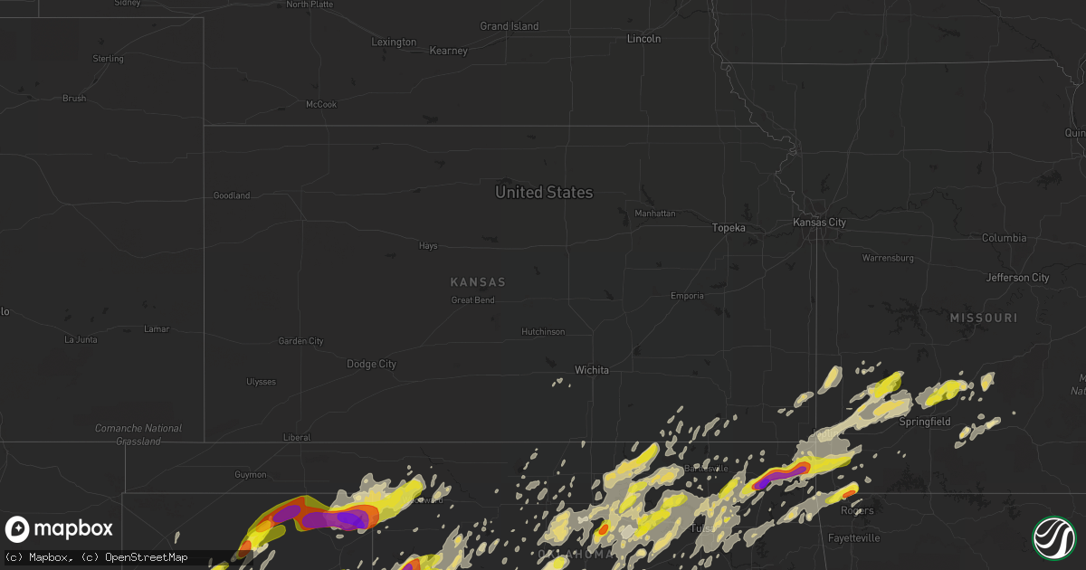
Hail Map in Kansas on May 20, 2019
Get this storm
May 20 map
$229
one time, instant access
Download today. No call, no setup
Keep the $229
Bought the map and want the full workflow? Apply the entire $229 to a subscription within 7 days. None of it is wasted.
Every map, not just this one
This buys you this map. Subscription and you get every map we run, in the markets you choose from a few cities to whole states to nationwide. Plus real-time alerts the moment a storm fires.
Contact data
Name, contact info, occupancy, even credit band for addresses in the footprint. You go from where it hit to who to call.
Become the source they trust
Unlimited branding weather history reports on demand. You already have the documented answer ready for the property owner, and you are the one who showed up with it.
Property data and RoofTrace estimates
Pull up any address you have got, its value and the exact code rules for that jurisdiction, straight from One Click Code. Then RoofTrace estimates the squares, pitch, and roof value, priced the way you price.
Storm reports in Kansas
Kansas
| Date | Description |
|---|---|
| 05/20/20196:50 PM CDT | Cooperative observer reports a three to four inch tree limb is down on highway 99 south of sedan. Time is estimated from radar. |
| 05/20/20196:39 PM CDT | . |
| 05/20/20194:23 PM CDT | Tornado reported on the ground. |
| 05/20/20194:23 PM CDT | Starting point for pittsburg... Ks ef-1 tornado. Numerous trees snapped. Numerous homes with roof loss. Outbuilings destroyed. |
| 05/20/20194:20 PM CDT | Spotter saw tornado. Time based on radar. |
| 05/20/20194:19 PM CDT | End point of weir ef-1 tornado. Numerous trees and outbuilings damaged. |
| 05/20/20194:14 PM CDT | Starting point for ef-1 weir tornado from may 20th. Numerous tree and outbuilding damage. |
| 05/20/20194:10 PM CDT | Trees down. Winds estimated at 70 mph. |
| 05/20/20194:10 PM CDT | Trees down. Winds estimated at 70 mph. |
| 05/20/20197:43 AM CDT | At 1243 PM CDT, a severe thunderstorm was located 5 miles southwest of White Oak, moving east at 45 mph. HAZARD...Ping pong ball size hail and 60 mph wind gusts. SOURCE...Radar indicated. IMPACT...People and animals outdoors will be injured. Expect hail damage to roofs, siding, windows, and vehicles. Expect wind damage to roofs, siding, and trees. Locations in or near the path include... Miami... Vinita... Jay... Grove... Commerce... Chelsea... Fairland... Afton... Quapaw... Langley... Adair... Bernice... Ketchum... Bluejacket... Wyandotte... Disney... Big Cabin... Pensacola... New Alluwe... Honey Creek State Park...This includes Interstate 44 between mile markers 266 and 324. |
| 05/20/20194:14 AM CDT | At 914 PM CDT, a severe thunderstorm was located over northeastern Joplin, moving northeast at 45 mph. HAZARD...60 mph wind gusts and quarter size hail. SOURCE...Radar indicated. IMPACT...Hail damage to vehicles is expected. Expect wind damage to roofs, siding, and trees. Locations impacted include... Joplin... Carthage... Webb City... Carl Junction... Oronogo... Carterville... Duquesne... Sarcoxie... Duenweg... Airport Drive... Leawood... Silver Creek... Alba... Purcell... Shoal Creek Drive... Saginaw... Carytown... Fidelity... Redings Mill... Avilla...This includes the following highways... Interstate 44 between mile markers 0 and 32. Interstate 49 between mile markers 33 and 50. |
| 05/20/20193:15 AM CDT | At 814 PM CDT, severe thunderstorms were located along a line extending from Fulton to near Arcadia to near Pittsburg, moving east at 40 mph. HAZARD...60 mph wind gusts. SOURCE...Radar indicated. IMPACT...Expect damage to roofs, siding, and trees. Locations impacted include... Prairie State Park... Nevada... Fort Scott... Lamar... Golden City... Liberal... Sheldon... Mulberry... Nashville... Mindenmines... Montevallo... Arcadia... Walker... Schell City... Bronaugh... Lamar Heights... Fulton... Moundville... Richards... Milo...This includes Interstate 49 between mile markers 57 and 107. |
| 05/20/20192:05 AM CDT | At 705 PM CDT, severe thunderstorms were located along a line extending from 5 miles east of Neodesha to near Liberty to South Coffeyville, moving northeast at 50 mph. HAZARD...60 mph wind gusts. SOURCE...Radar indicated. IMPACT...Expect damage to roofs, siding, and trees. Locations impacted include... Parsons, Chanute, Oswego, Erie, Chetopa, Altamont, St. Paul, Thayer, Edna, Mound Valley, Galesburg, Bartlett, Labette, Stark, Earlton, Lake Parsons, Parsons Tri City Airport, Angola, Dennis and Big Hill Lake. |
| 05/20/20191:57 AM CDT | At 657 PM CDT, severe thunderstorms were located along a line extending from 4 miles south of Dearing to 2 miles east of Barnsdall to 4 miles southeast of Glencoe, moving east at 45 mph. HAZARD...60 mph wind gusts and quarter size hail. SOURCE...Radar indicated. IMPACT...Hail damage to vehicles is expected. Expect wind damage to roofs, siding, and trees. Locations in or near the path include... Tulsa... Bartlesville... Sand Springs... Nowata... Pawhuska... Pawnee... Owasso... Skiatook... Collinsville... Hominy... Dewey... Cleveland... Chelsea... Barnsdall... Sperry... Oologah... South Coffeyville... Copan... Ramona... Wynona... |
| 05/20/20191:42 AM CDT | At 642 PM CDT, a severe thunderstorm was located near Independence, moving northeast at 80 mph. HAZARD...60 mph wind gusts. SOURCE...Radar indicated. IMPACT...Expect damage to roofs, siding, and trees. Locations impacted include... Coffeyville, Independence, Neodesha, Cherryvale, Caney, Sedan, Dearing, Altoona, Elk City, Tyro, Peru, Liberty, Chautauqua, Havana, Bolton, Sycamore, Niotaze, Elk City Lake, Elk City State Park and Hale. |
| 05/20/201912:40 AM CDT | At 540 AM CDT, a severe thunderstorm was located 5 miles south of Gruver, or 11 miles west of Spearman, moving northeast at 65 mph. HAZARD...Ping pong ball size hail and 60 mph wind gusts. SOURCE...Radar indicated. IMPACT...Minor damage to roofs, siding, and trees is possible. People and animals outdoors will be injured. Expect hail damage to roofs, siding, windows, and vehicles. Locations impacted include... Spearman, Gruver, Hardesty, Baker, Adams, Boyd and Turpin. |
| 05/19/201911:59 PM CDT | At 459 PM CDT, a severe thunderstorm was located near Seneca, or 9 miles east of Miami, moving northeast at 50 mph. HAZARD...60 mph wind gusts. SOURCE...Radar indicated. IMPACT...Expect damage to roofs, siding, and trees. Locations impacted include... Joplin... Carthage... Webb City... Carl Junction... Galena... Oronogo... Seneca... Carterville... Duquesne... Sarcoxie... Duenweg... Diamond... Loma Linda... Airport Drive... Leawood... Silver Creek... Shoal Creek Drive... Saginaw... Fidelity... Redings Mill...This includes the following highways... Interstate 44 between mile markers 0 and 31. Interstate 49 between mile markers 24 and 46. |
| 05/19/201911:43 PM CDT | At 443 PM CDT, severe thunderstorms were located along a line extending from near Chilocco to 3 miles northwest of Red Rock to 4 miles southeast of Garber to 5 miles south of Drummond, moving northeast at 50 mph. HAZARD...60 mph wind gusts and quarter size hail. SOURCE...Radar indicated. IMPACT...Hail damage to vehicles is expected. Expect wind damage to roofs, siding, and trees. Locations impacted include... Enid, Ponca City, Blackwell, Perry, Tonkawa, Medford, Newkirk, Hennessey, Waukomis, Pond Creek, Garber, Lahoma, Covington, Billings, Drummond, Lamont, Kaw City, Wakita, Red Rock and Marshall. |
| 05/19/201911:08 PM CDT | At 408 PM CDT, a severe thunderstorm was located over Scammon, or 9 miles north of Columbus, moving northeast at 50 mph. HAZARD...60 mph wind gusts. SOURCE...Radar indicated. IMPACT...Expect damage to roofs, siding, and trees. Locations impacted include... Pittsburg... Carthage... Prairie State Park... Carl Junction... Lamar... Frontenac... Columbus... Girard... Oronogo... Arma... Jasper... Golden City... Liberal... Cherokee... Weir... Alba... Mulberry... Scammon... Purcell... Chicopee...This includes Interstate 49 between mile markers 44 and 75. |
| 05/19/20198:13 PM CDT | At 112 PM CDT, a severe thunderstorm was located near Fairland, or 12 miles south of Miami, moving east at 45 mph. HAZARD...Golf ball size hail and 60 mph wind gusts. SOURCE...Radar indicated. IMPACT...People and animals outdoors will be injured. Expect hail damage to roofs, siding, windows, and vehicles. Expect wind damage to roofs, siding, and trees. Locations impacted include... Joplin... Carthage... Neosho... Webb City... Big Sugar Creek State Park... Seneca... Granby... Anderson... Carterville... Noel... Duquesne... Dodge... Sarcoxie... Goodman... Duenweg... South West City... Diamond... Pineville... Loma Linda... Wheaton...This includes the following highways... Interstate 44 between mile markers 0 and 31. Interstate 49 between mile markers 1 and 41. |
| 05/19/20197:45 PM CDT | Delayed report. Tree uprooted in walnut via social media. |
| 05/19/20197:40 PM CDT | Emergency manager reports a fifth wheeler turned over and pool deck is gone at 190th and victory. |
| 05/19/20197:30 PM CDT | Winds were really knocking the car around with estimated speeds of 55 to 60 mph. |
| 05/19/20197:30 PM CDT | Power poles snapped in the stark area. Power lines down. Delayed report. |
| 05/19/20197:30 PM CDT | Delayed report. Roof damage report down power lines. |
| 05/19/20197:09 PM CDT | Law enforcement reports three to four inch tree limbs down and as well as electrical poles. |
Cities Impacted by Hail Map on May 20, 2019
- Sikeston, MO
- Afton, OK
- Vinita, OK
- Chelsea, OK
- Big Cabin, OK
- Paducah, TX
- Hennessey, OK
- Tulia, TX
- Silverton, TX
- Rotan, TX
- Stillwater, OK
- Glencoe, OK
- Fort Cobb, OK
- Anadarko, OK
- Apache, OK
- Gracemont, OK
- Reeds, MO
- Joplin, MO
- Miller, MO
- Avilla, MO
- Dadeville, MO
- Golden City, MO
- Lamar, MO
- Stockton, MO
- Dunnegan, MO
- La Russell, MO
- Stotts City, MO
- Lockwood, MO
- Willard, MO
- Fair Play, MO
- Everton, MO
- Sarcoxie, MO
- Walnut Grove, MO
- Webb City, MO
- Carthage, MO
- Jasper, MO
- Ash Grove, MO
- Greenfield, MO
- Arcola, MO
- Duenweg, MO
- Diamond, MO
- South Greenfield, MO
- Lockney, TX
- Lookeba, OK
- Carnegie, OK
- Binger, OK
- Hydro, OK
- Buffalo, OK
- Ralston, OK
- Pawnee, OK
- Fairfax, OK
- Springfield, MO
- Fair Grove, MO
- Elkland, MO
- Pleasant Hope, MO
- Buffalo, MO
- Lakeview, TX
- Mangum, OK
- Duke, OK
- Wynona, OK
- Midland, TX
- Norwood, MO
- Mansfield, MO
- Macomb, MO
- Roosevelt, OK
- Hobart, OK
- Spavinaw, OK
- Chickasha, OK
- Ninnekah, OK
- Dimmitt, TX
- Nazareth, TX
- Hart, TX
- Tahoka, TX
- Lubbock, TX
- Wilson, TX
- Follett, TX
- Booker, TX
- Big Spring, TX
- Erick, OK
- Clarendon, TX
- Douglas, OK
- Fairmont, OK
- Waukomis, OK
- Pampa, TX
- Hedley, TX
- Lelia Lake, TX
- Cheyenne, OK
- Stanton, TX
- Dexter, MO
- Fisk, MO
- Bloomfield, MO
- Dudley, MO
- Grove, OK
- Miami, OK
- Mulhall, OK
- Skiatook, OK
- Morrison, OK
- Carterville, MO
- Jennings, OK
- Glenpool, OK
- Quapaw, OK
- Orlando, OK
- Barnsdall, OK
- Marshall, OK
- Oologah, OK
- Guthrie, OK
- Lucien, OK
- Agra, OK
- Crescent, OK
- Kaw City, OK
- Stark City, MO
- Ponca City, OK
- Burbank, OK
- Pawhuska, OK
- Fairland, OK
- Catoosa, OK
- Dover, OK
- Vera, OK
- Stroud, OK
- Coweta, OK
- Drumright, OK
- Coyle, OK
- Mounds, OK
- Goodman, MO
- Wellston, OK
- Cleveland, OK
- Maramec, OK
- Inola, OK
- Jenks, OK
- Sapulpa, OK
- Osage, OK
- Bixby, OK
- Bison, OK
- Collinsville, OK
- Picher, OK
- Neosho, MO
- Wyandotte, OK
- Sperry, OK
- Seneca, MO
- Baxter Springs, KS
- Chandler, OK
- Cushing, OK
- Tryon, OK
- Pierce City, MO
- Granby, MO
- Marland, OK
- Anderson, MO
- Covington, OK
- Bois D Arc, MO
- Carney, OK
- Wentworth, MO
- Delaware, OK
- Ramona, OK
- Ripley, OK
- Hominy, OK
- Terlton, OK
- Shidler, OK
- Sand Springs, OK
- Owasso, OK
- Prue, OK
- Nowata, OK
- Bristow, OK
- Morrisville, MO
- Aldrich, MO
- Broken Arrow, OK
- Adair, OK
- Mannford, OK
- Talala, OK
- Newkirk, OK
- Perry, OK
- Claremore, OK
- Jay, OK
- Bluejacket, OK
- Depew, OK
- Tulsa, OK
- Kiefer, OK
- Yale, OK
- Red Rock, OK
- Perkins, OK
- Galena, KS
- Borger, TX
- Woodward, OK
- Canadian, TX
- Fort Supply, OK
- Perryton, TX
- Laverne, OK
- Lipscomb, TX
- Gage, OK
- Fargo, OK
- Higgins, TX
- Shattuck, OK
- Mcadoo, TX
- Crosbyton, TX
- Morse, TX
- Stinnett, TX
- Spearman, TX
- Miami, TX
- Kingfisher, OK
- Seymour, TX
- Crowell, TX
- Vernon, TX
- Wellington, TX
- Childress, TX
- Pineville, MO
- Gravette, AR
- Noel, MO
- Seligman, MO
- Sulphur Springs, AR
- Bella Vista, AR
- Pea Ridge, AR
- Washburn, MO
- Powell, MO
- Conway, MO
- Enid, OK
- Hinton, OK
- Watonga, OK
- Canton, OK
- Salina, OK
- Wagoner, OK
- Chouteau, OK
- Locust Grove, OK
- Mclean, TX
- Electra, TX
- Munday, TX
- Goree, TX
- Post, TX
- Lamesa, TX
- Ackerly, TX
- O'Brien, TX
- Rochester, TX
- Rule, TX
- Knox City, TX
- Elk City, OK
- Hammon, OK
- Butler, OK
- Shamrock, TX
- Coahoma, TX
- Sedan, KS
- Peru, KS
- Medford, OK
- Dodson, TX
- Rush Springs, OK
- Gail, TX
- Sheldon, MO
- Liberal, MO
- Bronaugh, MO
- Willow, OK
- Leedey, OK
- Putnam, OK
- Taloga, OK
- Sayre, OK
- Custer City, OK
- Clinton, OK
- Plainview, TX
- Sentinel, OK
- Carter, OK
- Sweetwater, OK
- Little Rock, AR
- Paron, AR
- Alexander, AR
- Rogers, AR
- Bentonville, AR
- Arnett, OK
- Walters, OK
- Goldsmith, TX
- Ralls, TX
- Floydada, TX
- Welch, TX
- Odonnell, TX
- Mountain Grove, MO
- Cabool, MO
- Graff, MO
- Memphis, TX
- Okmulgee, OK
- Beggs, OK
- Canyon, TX
- Odessa, TX
- Blanchard, OK
- Lebanon, MO
- Iowa Park, TX
- Harrold, TX
- Nevada, MO
- Milo, MO
- Mindenmines, MO
- Faxon, OK
- Cedar Vale, KS
- Ringwood, OK
- Helena, OK
- Goltry, OK
- Union City, OK
- El Reno, OK
- Oklahoma City, OK
- Cordell, OK
- Gotebo, OK
- Amarillo, TX
- Wheeler, TX
- Thomas, OK
- Crawford, OK
- Briscoe, TX
- Reydon, OK
- Seiling, OK
- Chester, OK
- Texola, OK
- Oakwood, OK
- Durham, OK
- Shawnee, OK
- Westbrook, TX
- Garden City, TX
- Monett, MO
- Purdy, MO
- Quail, TX
- Minco, OK
- Old Glory, TX
- Independence, KS
- Monahans, TX
- Hunter, OK
- Aspermont, TX
- Snyder, TX
- Roby, TX
- Hamlin, TX
- Sweetwater, TX
- Yukon, OK
- Fordland, MO
- Seymour, MO
- Justiceburg, TX
- Fluvanna, TX
- Lonsdale, AR
- Hot Springs Village, AR
- Mooreland, OK
- Meno, OK
- Quanah, TX
- Piedmont, OK
- Midkiff, TX
- Girard, TX
- Eldorado, OK
- Burkburnett, TX
- Devol, OK
- Grandfield, OK
- Quitaque, TX
- Lorenzo, TX
- Idalou, TX
- Turkey, TX
- Matador, TX
- Knott, TX
- Gardendale, TX
- McCamey, TX
- Andrews, TX
- Loveland, OK
- Weir, KS
- Girard, KS
- Pittsburg, KS
- Frontenac, KS
- Cherokee, KS
- Hermleigh, TX
- Purcell, OK
- Granite, OK
- Prague, OK
- Paden, OK
- Mobeetie, TX
- Grovespring, MO
- Dewey, OK
- El Dorado Springs, MO
- Canute, OK
- Sasakwa, OK
- Hollis, OK
- Cee Vee, TX
- Spur, TX
- Weinert, TX
- Oklaunion, TX
- Davidson, OK
- Slaton, TX
- Dickens, TX
- Frederick, OK
- Randlett, OK
- Benjamin, TX
- Denham Springs, LA
- Pine Grove, LA
- Fairview, OK
- Luther, OK
- Long Lane, MO
- Phillipsburg, MO
- Masterson, TX
- Channing, TX
- Galena, MO
- Crane, MO
- Mcloud, OK
- Meeker, OK
- Dill City, OK
- Colcord, OK
- Rose, OK
- Cashion, OK
- Okarche, OK
- Okeene, OK
- Ada, OK
- Gould, OK
- Benton, AR
- Manchester, OK
- Poplar Bluff, MO
- Essex, MO
- Puxico, MO
- Ames, OK
- Noble, OK
- Lawton, OK
- Niangua, MO
- Hitchcock, OK
- Lenorah, TX
- Tarzan, TX
- Ira, TX
- Calumet, OK
- Geary, OK
- Vega, TX
- Pryor, OK
- Vinson, OK
- Wheaton, MO
- Rocky Comfort, MO
- Exeter, MO
- Fairview, MO
- Geronimo, OK
- Lone Wolf, OK
- Falcon, MO
- Mountain View, OK
- Marshfield, MO
- Dumas, TX
- Stella, MO
- Weatherford, OK
- Brighton, MO
- Bolivar, MO
- Half Way, MO
- Roaring Springs, TX
- Afton, TX
- Jerico Springs, MO
- Davenport, OK
- Canaan, ME
- Bartlesville, OK
- Vici, OK
- Mutual, OK
- Claude, TX
- Gentry, AR
- Eucha, OK
- South West City, MO
- Hiwasse, AR
- Decatur, AR
- Maysville, AR
- Newalla, OK
- Flomot, TX
- Roland, AR
- Braman, OK
- Colony, OK
- Cheney, KS
- Norwich, KS
- McCune, KS
- Oswego, KS
- Welch, OK
- Arapaho, OK
- Amber, OK
- Alex, OK
- Norman, OK
- Washington, OK
- Newcastle, OK
- Jet, OK
- Kellyville, OK
- Happy, TX
- Ava, MO
- Oldfield, MO
- Sparta, MO
- Seagraves, TX
- Longdale, OK
- Loraine, TX
- Colorado City, TX
- Broseley, MO
- Gate, OK
- Cache, OK
- Sharon, OK
- Arcadia, OK
- Garber, OK
- Kremlin, OK
- Tishomingo, OK
- Kenefic, OK
- Milburn, OK
- Sunray, TX
- Kansas, OK
- Chillicothe, TX
- Pocasset, OK
- Niotaze, KS
- Caney, KS
- Havana, KS
- Brownfield, TX
- Darrouzett, TX
- Balko, OK
- May, OK
- Viola, KS
- Carrier, OK
- Tuttle, OK
- Tonkawa, OK
- Billings, OK
- Tecumseh, OK
- Coleman, OK
- Moline, KS
- Fritch, TX
- Skowhegan, ME
- Corn, OK
- Marlow, OK
- Fletcher, OK
- Bradley, OK
- Nash, OK
- Edmond, OK
- Wakita, OK
- Lindsay, OK
- Madill, OK
- Scammon, KS
- West Mineral, KS
- Cherryvale, KS
- Drummond, OK
- Hartville, MO
- Greensburg, LA
- Seminole, TX
- Dalhart, TX
- Aline, OK
- Boley, OK
- Castle, OK
- Verden, OK
- Haskell, TX
- McCaulley, TX
- Hollister, OK
- Jayton, TX
- Crane, TX
- Sylvester, TX
- Roscoe, TX
- Panhandle, TX
- Lamont, OK
- Tiff City, MO
- Jessieville, AR
- Gruver, TX
- Wolfforth, TX
- Sheffield, TX
- Ozona, TX


