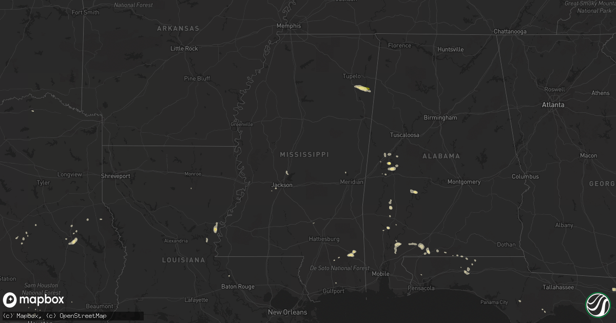
Hail Map in Mississippi on May 20, 2015
Get this storm
May 20 map
$229
one time, instant access
Download today. No call, no setup
Keep the $229
Bought the map and want the full workflow? Apply the entire $229 to a subscription within 7 days. None of it is wasted.
Every map, not just this one
This buys you this map. Subscription and you get every map we run, in the markets you choose from a few cities to whole states to nationwide. Plus real-time alerts the moment a storm fires.
Contact data
Name, contact info, occupancy, even credit band for addresses in the footprint. You go from where it hit to who to call.
Become the source they trust
Unlimited branding weather history reports on demand. You already have the documented answer ready for the property owner, and you are the one who showed up with it.
Property data and RoofTrace estimates
Pull up any address you have got, its value and the exact code rules for that jurisdiction, straight from One Click Code. Then RoofTrace estimates the squares, pitch, and roof value, priced the way you price.
Storm reports in Mississippi
Mississippi
| Date | Description |
|---|---|
| 05/20/20155:16 PM CDT | Public reports of quarter and dime sized hail near smithville... Reports via social media |
| 05/20/20154:50 PM CDT | A few large trees down near gatlin creek and st. Ellen roads. |
| 05/20/20154:25 PM CDT | County em reports a large tree down over big four rd. |
| 05/20/20153:06 PM CDT | Several small trees down west of runnelstown. |
| 05/20/20152:23 PM CDT | 3 trees blown down in the williamsburg community. |
| 05/20/20152:14 PM CDT | Several trees downed around the city of laurel including one downed on a deputies car. |
All States Impacted by Hail Map on May 20, 2015
Cities Impacted by Hail Map on May 20, 2015
- Sonora, TX
- Mertzon, TX
- Interlachen, FL
- Jarrell, TX
- Georgetown, TX
- Florence, TX
- De Leon Springs, FL
- Forkland, AL
- Boligee, AL
- Yemassee, SC
- Fort Stockton, TX
- Akron, AL
- Burnet, TX
- Alberta, AL
- Mckinney, TX
- Allen, TX
- Frisco, TX
- Rocksprings, TX
- Junction, TX
- Manning, SC
- Greeleyville, SC
- Jackson, AL
- Leroy, AL
- Oviedo, FL
- Nacogdoches, TX
- Mountain Home, TX
- Barnhart, TX
- Rhome, TX
- Decatur, TX
- Paradise, TX
- Bridgeport, TX
- Boyd, TX
- Springer, OK
- Ardmore, OK
- Big Lake, TX
- Vidalia, LA
- Jonesville, LA
- Llano, TX
- Mason, TX
- Saint Cloud, FL
- Marathon, TX
- Ozona, TX
- Waller, TX
- Defuniak Springs, FL
- Saint Augustine, FL
- Deland, FL
- Brewton, AL
- Eldorado, TX
- La Pryor, TX
- Melrose, FL
- Oakwood, TX
- Centerville, TX
- Fredericksburg, TX
- Live Oak, FL
- Prosper, TX
- Celina, TX
- Seminary, MS
- Collins, MS
- Lufkin, TX
- Plano, TX
- Smithville, MS
- Nettleton, MS
- Amory, MS
- Lincoln, TX
- Alvord, TX
- Deltona, FL
- Barksdale, TX
- Leakesville, MS
- McLain, MS
- Lucedale, MS
- Frostproof, FL
- Livingston, AL
- Lake Wales, FL
- Madill, OK
- Huntington, TX
- Comanche, OK
- Dryden, TX
- Duncan, OK
- Ratliff City, OK
- Biloxi, MS
- Graham, TX
- Mims, FL
- Eagle Pass, TX
- Crockett, TX
- Titusville, FL
- Hosford, FL
- Sulphur, OK
- Eutaw, AL
- Florala, AL
- Davis, OK
- Little River, AL
- Palo Pinto, TX
- Thomasville, AL
- Harper, TX
- Bristol, FL
- Graham, OK
- Healdton, OK
- Wilson, OK
- Green Cove Springs, FL
- Wiggins, MS
- Uvalde, TX
- Wagarville, AL
- Buchanan Dam, TX
- Elkhart, TX
- Grapeland, TX
- Del Rio, TX
- Monterey, LA
- Glynn, LA
- River Ranch, FL
- Willow City, TX
- Geneva, FL
- Osteen, FL
- Crestview, FL
- Crystal City, TX
- Shelbyville, TX
- Center, TX
- Ferriday, LA
- Georgetown, FL
- Crescent City, FL
- Roosevelt, TX
- Grove Hill, AL
- Hastings, FL
- Okeechobee, FL
- Pilot Point, TX
- Westville, FL
- San Saba, TX
- Fort McCoy, FL
- Corsicana, TX
- Houston, TX
- Holland, TX
- Bartlett, TX
- Leander, TX
- Raymond, MS
- Orange City, FL
- Justin, TX
- Haslet, TX
- Marble Falls, TX
- Carrizo Springs, TX
- Tomball, TX
- Kenansville, FL
- Milton, FL
- Gordon, TX
- Santo, TX
- Sawyerville, AL
- Mannsville, OK
- Castell, TX
- Doss, TX
- Big Wells, TX
- Andalusia, AL
- Hilton Head Island, SC
- Forestburg, TX
- Liberty Hill, TX
- Ponte Vedra Beach, FL
- Humble, TX
- Estero, FL
- Stockton, AL
- Beaufort, SC
- Columbia, LA
- Port Charlotte, FL
- Orlando, FL
- Carrabelle, FL
- Christmas, FL
- Salado, TX
- Brooklyn, MS
- Pearland, TX
- Rosharon, TX
- Manvel, TX
- Jackson, MS
- Valley Spring, TX
- Lockhart, AL
- Laurel Hill, FL
- Asherton, TX
- Gallion, AL
- Atmore, AL
- Paris, TX
- Catherine, AL
- Collinsville, MS
- White Springs, FL
- Hull, TX
- Edgewater, FL
- Batesville, TX
- Valley View, TX
- Sweet Water, AL
- Madison, MS
- Canton, MS
- Diboll, TX
- Wing, AL
- Hawthorne, FL
- Ponte Vedra, FL
- Mount Dora, FL
- Alpine, TX


