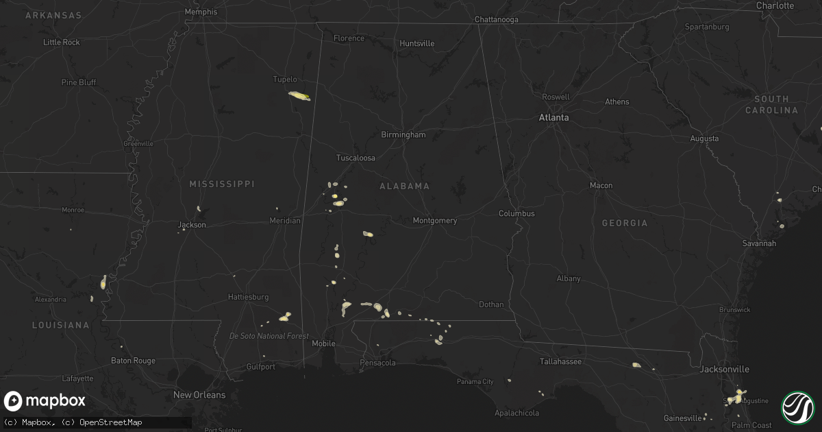
Hail Map in Alabama on May 20, 2015
Get this storm
May 20 map
$229
one time, instant access
Download today. No call, no setup
Keep the $229
Bought the map and want the full workflow? Apply the entire $229 to a subscription within 7 days. None of it is wasted.
Every map, not just this one
This buys you this map. Subscription and you get every map we run, in the markets you choose from a few cities to whole states to nationwide. Plus real-time alerts the moment a storm fires.
Contact data
Name, contact info, occupancy, even credit band for addresses in the footprint. You go from where it hit to who to call.
Become the source they trust
Unlimited branding weather history reports on demand. You already have the documented answer ready for the property owner, and you are the one who showed up with it.
Property data and RoofTrace estimates
Pull up any address you have got, its value and the exact code rules for that jurisdiction, straight from One Click Code. Then RoofTrace estimates the squares, pitch, and roof value, priced the way you price.
Storm reports in Alabama
Alabama
| Date | Description |
|---|---|
| 05/20/20156:55 PM CDT | A local report indicates 1.00 inch wind near E BREWTON |
| 05/20/20156:52 PM CDT | Tree down on appleton road north of brewton. |
| 05/20/20155:09 PM CDT | County em reports trees down along walker springs rd. Time estimated via radar. |
| 05/20/20155:04 PM CDT | Clarke county em reports trees down along gainestown rd. Time estimated from radar. |
| 05/20/20155:03 PM CDT | County em reports tree through the roof stick-built house on guy avenue. Time estimated from radar. |
| 05/20/20155:00 PM CDT | Emergency manager reported several trees and power lines down at various locations across the county as a couple of strong storms moved across the county around 5oo pm. |
| 05/20/20154:59 PM CDT | County em reports trees down on old hwy 84. Time estimated from radar. |
| 05/20/20154:44 PM CDT | County em reported trees down along cherry drive. Time estimated from radar. |
| 05/20/20154:44 PM CDT | County em reports trees down along hwy 154. Time estimated from radar. |
| 05/20/20154:34 PM CDT | County em reports trees down along tallahatta springs rd. Time estimated via radar. |
| 05/20/20154:29 PM CDT | Clarke county em reports trees down along prospect rd. Time estimated via radar. |
| 05/20/20154:20 PM CDT | County em reports trees down along norris rd. Time estimated from radar. |
| 05/20/20153:35 PM CDT | Small tree in the road on bear creek road. Quickly cleared by volunteer fd. |
| 05/20/20153:08 PM CDT | Hail up to the size of a half dollar fell briefly in dollarhide. |
| 05/20/20153:08 PM CDT | Trees and power lines down along cr 11. |
| 05/20/20152:18 PM CDT | Trees and power lines down near the intersection of al 14 and green cr 60. |
All States Impacted by Hail Map on May 20, 2015
Cities Impacted by Hail Map on May 20, 2015
- Sonora, TX
- Mertzon, TX
- Interlachen, FL
- Jarrell, TX
- Georgetown, TX
- Florence, TX
- De Leon Springs, FL
- Forkland, AL
- Boligee, AL
- Yemassee, SC
- Fort Stockton, TX
- Akron, AL
- Burnet, TX
- Alberta, AL
- Mckinney, TX
- Allen, TX
- Frisco, TX
- Rocksprings, TX
- Junction, TX
- Manning, SC
- Greeleyville, SC
- Jackson, AL
- Leroy, AL
- Oviedo, FL
- Nacogdoches, TX
- Mountain Home, TX
- Barnhart, TX
- Rhome, TX
- Decatur, TX
- Paradise, TX
- Bridgeport, TX
- Boyd, TX
- Springer, OK
- Ardmore, OK
- Big Lake, TX
- Vidalia, LA
- Jonesville, LA
- Llano, TX
- Mason, TX
- Saint Cloud, FL
- Marathon, TX
- Ozona, TX
- Waller, TX
- Defuniak Springs, FL
- Saint Augustine, FL
- Deland, FL
- Brewton, AL
- Eldorado, TX
- La Pryor, TX
- Melrose, FL
- Oakwood, TX
- Centerville, TX
- Fredericksburg, TX
- Live Oak, FL
- Prosper, TX
- Celina, TX
- Seminary, MS
- Collins, MS
- Lufkin, TX
- Plano, TX
- Smithville, MS
- Nettleton, MS
- Amory, MS
- Lincoln, TX
- Alvord, TX
- Deltona, FL
- Barksdale, TX
- Leakesville, MS
- McLain, MS
- Lucedale, MS
- Frostproof, FL
- Livingston, AL
- Lake Wales, FL
- Madill, OK
- Huntington, TX
- Comanche, OK
- Dryden, TX
- Duncan, OK
- Ratliff City, OK
- Biloxi, MS
- Graham, TX
- Mims, FL
- Eagle Pass, TX
- Crockett, TX
- Titusville, FL
- Hosford, FL
- Sulphur, OK
- Eutaw, AL
- Florala, AL
- Davis, OK
- Little River, AL
- Palo Pinto, TX
- Thomasville, AL
- Harper, TX
- Bristol, FL
- Graham, OK
- Healdton, OK
- Wilson, OK
- Green Cove Springs, FL
- Wiggins, MS
- Uvalde, TX
- Wagarville, AL
- Buchanan Dam, TX
- Elkhart, TX
- Grapeland, TX
- Del Rio, TX
- Monterey, LA
- Glynn, LA
- River Ranch, FL
- Willow City, TX
- Geneva, FL
- Osteen, FL
- Crestview, FL
- Crystal City, TX
- Shelbyville, TX
- Center, TX
- Ferriday, LA
- Georgetown, FL
- Crescent City, FL
- Roosevelt, TX
- Grove Hill, AL
- Hastings, FL
- Okeechobee, FL
- Pilot Point, TX
- Westville, FL
- San Saba, TX
- Fort McCoy, FL
- Corsicana, TX
- Houston, TX
- Holland, TX
- Bartlett, TX
- Leander, TX
- Raymond, MS
- Orange City, FL
- Justin, TX
- Haslet, TX
- Marble Falls, TX
- Carrizo Springs, TX
- Tomball, TX
- Kenansville, FL
- Milton, FL
- Gordon, TX
- Santo, TX
- Sawyerville, AL
- Mannsville, OK
- Castell, TX
- Doss, TX
- Big Wells, TX
- Andalusia, AL
- Hilton Head Island, SC
- Forestburg, TX
- Liberty Hill, TX
- Ponte Vedra Beach, FL
- Humble, TX
- Estero, FL
- Stockton, AL
- Beaufort, SC
- Columbia, LA
- Port Charlotte, FL
- Orlando, FL
- Carrabelle, FL
- Christmas, FL
- Salado, TX
- Brooklyn, MS
- Pearland, TX
- Rosharon, TX
- Manvel, TX
- Jackson, MS
- Valley Spring, TX
- Lockhart, AL
- Laurel Hill, FL
- Asherton, TX
- Gallion, AL
- Atmore, AL
- Paris, TX
- Catherine, AL
- Collinsville, MS
- White Springs, FL
- Hull, TX
- Edgewater, FL
- Batesville, TX
- Valley View, TX
- Sweet Water, AL
- Madison, MS
- Canton, MS
- Diboll, TX
- Wing, AL
- Hawthorne, FL
- Ponte Vedra, FL
- Mount Dora, FL
- Alpine, TX


