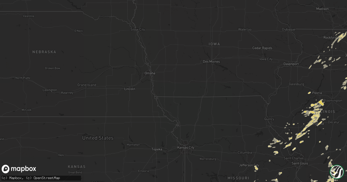
Hail Map in Wisconsin on May 20, 2012
Get this storm
May 20 map
$229
one time, instant access
Download today. No call, no setup
Keep the $229
Bought the map and want the full workflow? Apply the entire $229 to a subscription within 7 days. None of it is wasted.
Every map, not just this one
This buys you this map. Subscription and you get every map we run, in the markets you choose from a few cities to whole states to nationwide. Plus real-time alerts the moment a storm fires.
Contact data
Name, contact info, occupancy, even credit band for addresses in the footprint. You go from where it hit to who to call.
Become the source they trust
Unlimited branding weather history reports on demand. You already have the documented answer ready for the property owner, and you are the one who showed up with it.
Property data and RoofTrace estimates
Pull up any address you have got, its value and the exact code rules for that jurisdiction, straight from One Click Code. Then RoofTrace estimates the squares, pitch, and roof value, priced the way you price.
Storm reports in Wisconsin
Wisconsin
| Date | Description |
|---|---|
| 05/20/20125:46 PM CDT | Trees and power lines down |
| 05/20/20125:42 PM CDT | Trees and power lines down |
| 05/20/20125:42 PM CDT | A local report indicates 1.00 inch wind near AMBERG |
| 05/20/20124:42 PM CDT | Wires down |
| 05/20/20124:42 PM CDT | Tree down |
| 05/20/20124:42 PM CDT | Wires down. |
| 05/20/20124:37 PM CDT | A tree and powerline reported down in the lyons area...northeast of lake geneva. |
| 05/20/20124:37 PM CDT | Tree down in bloomfield which is in the pell lake area. |
| 05/20/20124:05 PM CDT | Trees and power lines down |
| 05/20/20123:55 PM CDT | Trees and power lines down |
| 05/20/20123:15 PM CDT | Trees and power lines down along highway 45...courtesy of wsaw. |
| 05/20/20123:00 PM CDT | On hwy 17. |
| 05/20/20122:41 PM CDT | A local report indicates 1.00 inch wind near 3 N SUGAR CAMP |
| 05/20/20122:30 PM CDT | Delayed report from wsaw tv-7. |
| 05/20/20122:15 PM CDT | Trees down along highway 8 |
| 05/20/20122:05 PM CDT | A local report indicates 1.00 inch wind near 5 SW PHILLIPS |
| 05/20/20122:00 PM CDT | Roof blown off an older building along county hwy a near the taylor and marathon county line |
| 05/20/20121:48 PM CDT | A local report indicates 1.75 inch wind near LAC DU FLAMBEAU |
| 05/20/20121:39 PM CDT | A lot of penny to nickel hail size hail stones...along with a few quarter size. |
| 05/20/20121:22 PM CDT | Hail lasted about 5 minutes and covered the ground. |
| 05/20/20121:16 PM CDT | A local report indicates 1.00 inch wind near 15 E PHILLIPS |
| 05/20/201212:50 PM CDT | A local report indicates 1.00 inch wind near 4 NNE CORNELL |
| 05/20/201212:50 PM CDT | A local report indicates 1.00 inch wind near NNE CORNELL |
| 05/20/201212:45 PM CDT | A local report indicates 1.00 inch wind near 4 E STETSONVILLE |
| 05/20/201212:39 PM CDT | Tree branches down |
| 05/20/201212:39 PM CDT | 8 inch diameter tree branches down |
| 05/20/201212:00 PM CDT | A local report indicates 1.00 inch wind near 1 NE MELLEN |
All States Impacted by Hail Map on May 20, 2012
Cities Impacted by Hail Map on May 20, 2012
- Clay, KY
- Central Lake, MI
- Bellaire, MI
- Kampsville, IL
- Eldred, IL
- White Hall, IL
- Mendota, IL
- Crystal Falls, MI
- Compton, IL
- West Brooklyn, IL
- Paw Paw, IL
- Sparta, IL
- Gilman, IL
- Ashkum, IL
- Danforth, IL
- Vulcan, MI
- Foster City, MI
- Felch, MI
- Springfield, IL
- Hillsboro, TN
- Bourbon, MO
- Marengo, IL
- Harvard, IL
- Amboy, IL
- Ohio, IL
- Harmon, IL
- Walnut, IL
- Deer Grove, IL
- Tampico, IL
- Tomahawk, WI
- Stetsonville, WI
- Dorchester, WI
- Abbotsford, WI
- Rib Lake, WI
- Merrill, WI
- Ogema, WI
- Medford, WI
- Petersburg, IL
- Spencer, TN
- Clarksville, TN
- Adams, TN
- Cedar Hill, TN
- Phillips, WI
- Thomasboro, IL
- Gifford, IL
- Urbana, IL
- Saint Joseph, IL
- Emden, IL
- Hartsburg, IL
- San Jose, IL
- Mason City, IL
- New Holland, IL
- Portageville, MO
- Hayti, MO
- Eland, WI
- Wittenberg, WI
- Birnamwood, WI
- Jonesboro, IL
- Anna, IL
- Cobden, IL
- Easton, IL
- Greenview, IL
- Osseo, WI
- Salem, MO
- Cedar Grove, TN
- Sturgis, KY
- Batchtown, IL
- Elsberry, MO
- Hardin, IL
- Foley, MO
- Boulder Junction, WI
- Woodruff, WI
- Hardyville, KY
- Center, KY
- Fulton, KY
- Duncan, OK
- Calico Rock, AR
- Watersmeet, MI
- Scheller, IL
- Tamaroa, IL
- Du Quoin, IL
- Sesser, IL
- Glidden, WI
- Franklin, IL
- Winter, WI
- Forest City, IL
- Manito, IL
- Green Valley, IL
- Electra, TX
- Atlanta, GA
- Lake City, MI
- Owen, WI
- Curtiss, WI
- Fairbury, IL
- Pontiac, IL
- Marlow, OK
- Eldorado, IL
- Athens, IL
- Edmonton, KY
- Bowling Green, MO
- Clarksville, MO
- Eolia, MO
- Gwinn, MI
- Montgomery, IN
- Hornersville, MO
- Blytheville, AR
- Manila, AR
- Leachville, AR
- Dell, AR
- Kirksey, KY
- Comanche, OK
- Saint Joe, AR
- Yukon, OK
- El Reno, OK
- Rochester, IL
- Dawson, IL
- Riverton, IL
- Bonnots Mill, MO
- Loose Creek, MO
- Linn, MO
- San Jon, NM
- Bard, NM
- Crawfordsville, AR
- Marion, AR
- Helena, OK
- Ringwood, OK
- Cleo Springs, OK
- Aline, OK
- Bloomfield, IN
- Springville, IN
- Lake Linden, MI
- Marenisco, MI
- Ontonagon, MI
- Ewen, MI
- Conover, WI
- Phelps, WI
- Eagle River, WI
- Gleason, WI
- Irma, WI
- Bertrand, MO
- Charleston, MO
- Toivola, MI
- Harrisburg, IL
- Greencastle, IN
- Reelsville, IN
- Republic, MO
- Springfield, MO
- Negaunee, MI
- Sonora, KY
- Sheldon, WI
- Middletown, MO
- Cutler, IL
- Walsh, IL
- Baldwin, IL
- New Berlin, IL
- Pleasant Plains, IL
- Mount Vernon, IL
- Hamilton, AL
- Hackleburg, AL
- Gainesville, MO
- Hawk Point, MO
- Troy, MO
- Belzoni, MS
- Itta Bena, MS
- Buckley, IL
- Loda, IL
- Roberts, IL
- Bingham, IL
- Loyal, WI
- Chapin, IL
- Meredosia, IL
- Bluffs, IL
- Chandlerville, IL
- Tallula, IL
- Ashland, IL
- Channing, MI
- Champion, MI
- Ishpeming, MI
- Odell, IL
- Land O'Lakes, WI
- Trout Creek, MI
- Dyer, IN
- Davidson, OK
- Harrold, TX
- Osceola, AR
- Gorham, IL
- Charlevoix, MI
- Roodhouse, IL
- Murrayville, IL
- Morris, IL
- Hurley, WI
- Ironwood, MI
- Tutwiler, MS
- Clarksdale, MS
- Buffalo, IL
- Marble Hill, MO
- Glenallen, MO
- Latham, IL
- Mount Pulaski, IL
- Upson, WI
- Freeburg, MO
- Vega, TX
- Saxon, WI
- Odin, IL
- Sandoval, IL
- Ridgway, IL
- Omaha, IL
- Willard, MO
- Wakefield, MI
- Mcminnville, TN
- Woodbury, TN
- Parma, MO
- Catron, MO
- New Madrid, MO
- Sikeston, MO
- East Prairie, MO
- Matthews, MO
- Westboro, WI
- Jackson, MO
- Fieldon, IL
- Hereford, TX
- Hitchcock, OK
- Watonga, OK
- Clinton, KY
- Mellen, WI
- Mechanicsburg, IL
- Minocqua, WI
- Lac Du Flambeau, WI
- Fleming, CO
- Otis, CO
- Dwight, IL
- Washington Island, WI
- Morrison, TN
- Butler, IL
- Raymond, IL
- Irving, IL
- Smithboro, IL
- Greenville, IL
- Pueblo, CO
- Shelburn, IN
- Noble, MO
- Paragould, AR
- Rolling Fork, MS
- Anguilla, MS
- Yazoo City, MS
- Louise, MS
- Centralia, IL
- Walnut Hill, IL
- Ironton, MO
- Murphysboro, IL
- Altamont, IL
- Norway, MI
- Chrisman, IL
- Mass City, MI
- Bruce Crossing, MI
- Willow, OK
- Woodlawn, IL
- Bath, IL
- Kilbourne, IL
- Holliday, TX
- Alexander, IL
- Cantrall, IL
- Garden Prairie, IL
- Woodstock, IL
- Patoka, IL
- Salem, IL
- Carbondale, IL
- Pomona, IL
- Alto Pass, IL
- Turrell, AR
- Gilmore, AR
- Rochelle, IL
- Thawville, IL
- Paducah, KY
- Boaz, KY
- Symsonia, KY
- Butternut, WI
- Antigo, WI
- Aniwa, WI
- Vina, AL
- Detroit, AL
- Beaverton, AL
- Sulligent, AL
- Vanzant, MO
- Hanna City, IL
- Trivoli, IL
- Saint Clair, MO
- Palmyra, IL
- Modesto, IL
- Wrights, IL
- Greenfield, IL
- Martin, TN
- Elmwood, TN
- Carthage, TN
- Ava, IL
- Grand Tower, IL
- Jacob, IL
- Rockwood, IL
- Rumsey, KY
- Medora, IL
- Rockbridge, IL
- Chesterfield, IL
- Seymour, TX
- Williamsville, IL
- Sherman, IL
- Elkhart, IL
- Middletown, IL
- Dixon, MO
- Avondale, CO
- Daggett, MI
- Gilman, WI
- Jerseyville, IL
- Grafton, IL
- Townsend, WI
- White Lake, WI
- Marion, KY
- Mountain Home, AR
- Mayfield, KY
- Hickory, KY
- Benton, KY
- Taylorville, IL
- Edinburg, IL
- Lambert, MS
- Jacksonville, IL
- Benton, IL
- Waltonville, IL
- Bonnie, IL
- Greenfield, TN
- Hancock, MI
- Scott City, MO
- Cape Girardeau, MO
- McClure, IL
- Chaffee, MO
- Dix, IL
- Hickman, KY
- Tiptonville, TN
- Waukomis, OK
- Deerton, MI
- Lincoln, IL
- Martinton, IL
- Mineral, IL
- Annawan, IL
- Vance, MS
- Pleasant Shade, TN
- Granville, TN
- Gainesboro, TN
- Doe Run, MO
- Bismarck, MO
- Brantwood, WI
- Catawba, WI
- Tripoli, WI
- Prentice, WI
- Withee, WI
- Udall, MO
- Caulfield, MO
- Bakersfield, MO
- Earlville, IL
- Loco, OK
- Mangum, OK
- Vinson, OK
- Laona, WI
- Wabeno, WI
- Luxora, AR
- Granton, WI
- Wausaukee, WI
- Crivitz, WI
- Atlantic Mine, MI
- Marquand, MO
- Proctor, AR
- Watseka, IL
- Oklahoma City, OK
- Pembine, WI
- Hartsville, TN
- Delavan, IL
- Armington, IL
- Hopedale, IL
- Skandia, MI
- Trenary, MI
- Meno, OK
- Lahoma, OK
- Plainville, IN
- Poplar Grove, IL
- Capron, IL
- Park Falls, WI
- Coleman, WI
- Oconto Falls, WI
- Suring, WI
- Pound, WI
- Lena, WI
- Armstrong Creek, WI
- Florence, WI
- Fence, WI
- Gardner, IL
- Lexington, TN
- Manchester, TN
- Ewing, IL
- Ina, IL
- Carrollton, AL
- Isabella, MO
- Gosport, IN
- Hawkins, WI
- Vernon, TX
- Oklaunion, TX
- Dowelltown, TN
- Liberty, TN
- Keshena, WI
- Neopit, WI
- Nokomis, IL
- Franklin, IN
- Mulkeytown, IL
- Franklin Grove, IL
- Mountain Grove, MO
- Westcliffe, CO
- Williamsburg, MI
- Alden, MI
- Rapid City, MI
- Traverse City, MI
- Ellsworth, MI
- East Jordan, MI
- Walters, OK
- Lawton, OK
- Almo, KY
- Murray, KY
- Dundee, MS
- West Memphis, AR
- Kennan, WI
- Truxton, MO
- Warrenton, MO
- Waverly, IL
- Medina, TN
- De Witt, AR
- Sparta, TN
- Calhoun, KY
- Aliceville, AL
- Union City, OK
- Fairmount, IL
- Crown Point, IN
- Lowell, IN
- Oakford, IL
- Worthington, IN
- Lindenwood, IL
- Athelstane, WI
- Genoa, IL
- Kingston, IL
- Belvidere, IL
- Saint James, MO
- Cuba, MO
- Girard, IL
- Sault Sainte Marie, MI
- Fairfield, IL
- Lyons, IN
- Loretto, TN
- Blanchard, OK
- Steelville, MO
- Erick, OK
- Hamburg, IL
- Arbyrd, MO
- Tuscola, IL
- Whitehall, WI
- Hixton, WI
- Crenshaw, MS
- Tremont, IL
- Kingsley, MI
- Caruthersville, MO
- Hermann, MO
- Killen, AL
- Lexington, AL
- Gary, IN
- Lake Station, IN
- Bark River, MI
- Stephenson, MI
- Pleasant View, TN
- Chapmansboro, TN
- West Bend, WI
- Niagara, WI
- Dunbar, WI
- Fithian, IL
- Homer, IL
- Elizabethtown, IL
- Duke, MO
- Campbell Hill, IL
- Pinckneyville, IL
- Republic, MI
- Trilla, IL
- Trenton, KY
- Guthrie, KY
- Shobonier, IL
- Vernon, IL
- Vandalia, IL
- Sugar Grove, IL
- Pittsfield, IL
- Pearl, IL
- Ashland, WI
- Ojibwa, WI
- Silex, MO
- Bellflower, MO
- Wilson, AR
- Nara Visa, NM
- Ramsey, IL
- Hillview, IL
- Tolono, IL
- Enid, OK
- Argonne, WI
- Lake Village, IN
- Demotte, IN
- Thayer, IN
- Marquette, MI
- Rhinelander, WI
- Calumet, OK
- Geary, OK
- Rochester, IN
- Arcola, IL
- Chatham, MI
- Horse Cave, KY
- Greensburg, KY
- Holcombe, WI
- Ladysmith, WI
- Trezevant, TN
- Atwood, TN
- Amberg, WI
- Berger, MO
- Milan, TN
- Bethany, OK
- Lavinia, TN
- Huntingdon, TN
- Paxton, IL
- Mazon, IL
- Coal City, IL
- Wilmington, IL
- Braceville, IL
- Cornell, WI
- Harshaw, WI
- Hazelhurst, WI
- Virden, IL
- Amasa, MI
- Marks, MS
- Rockland, MI
- Patton, MO
- Glen Flora, WI
- Steele, MO
- Minier, IL
- Saint Elmo, IL
- Annapolis, MO
- Chassell, MI
- Ogden, IL
- Peachtree Corners, GA
- Roswell, NM
- Mackinaw, IL
- Carrollton, IL
- Atlanta, IL
- Kewadin, MI
- Leroy, MI
- La Moille, IL
- Arlington, IL
- Malden, IL
- Watton, MI
- Big Clifty, KY
- Kennett, MO
- Rush Springs, OK
- Bruce, WI
- Sheffield, IL
- Whittington, IL
- Huntingburg, IN
- Momence, IL
- Three Lakes, WI
- Hinton, OK
- Yuma, CO
- Rossville, IL
- Sublette, IL
- Harrison, AR
- Omaha, AR
- Kell, IL
- Alpharetta, GA
- Cumming, GA
- Dana, IN
- Ridge Farm, IL
- Vichy, MO
- Logansport, IN
- Griggsville, IL
- Chambersburg, IL
- Lookeba, OK
- Clay City, IL
- Exeland, WI
- Sullivan, MO
- Paw Paw, MI
- Gobles, MI
- Rapid River, MI
- Dora, MO
- Hartland, WI
- Fillmore, IL
- Mancelona, MI
- Cadott, WI
- Chippewa Falls, WI
- Tecumseh, MO
- Edinburgh, IN
- Pointe Aux Pins, MI
- Greenup, IL
- Brookline, MO
- Grant Park, IL
- Beecher, IL
- Buncombe, IL
- Dodgeville, MI
- Houghton, MI
- South Range, MI
- Painesdale, MI
- Dale, IN
- New Salem, IL
- Au Train, MI
- Geff, IL
- Sims, IL
- South Boardman, MI
- Iron River, MI
- Slinger, WI
- Summit Lake, WI
- Ashley, IL
- Steeleville, IL
- Bluford, IL
- Christopher, IL
- Chester, IL
- Percy, IL
- Buckner, IL
- Texico, IL
- Covington, MI
- Tustin, MI
- Cherry, IL
- Princeton, IL
- Harbor Springs, MI
- Chana, IL
- Knox, IN
- Steward, IL
- Lakewood, WI
- Patoka, IN
- Decker, IN
- Crandon, WI
- New Auburn, WI
- Cascade, WI
- Adell, WI
- Dixon, IL
- Kirkland, IL
- Cherry Valley, IL
- Monroe Center, IL
- Hebron, IL
- Iliff, CO
- Padroni, CO
- Hebron, IN
- Wheatfield, IN
- Ringle, WI
- Binger, OK
- Minco, OK
- Rock, MI
- Pocasset, OK
- Frohna, MO
- Hermansville, MI
- Delaplaine, AR
- Makanda, IL
- Island, KY
- Sacramento, KY
- Kewanna, IN
- Lucerne, IN
- Twelve Mile, IN
- Tremont, MS
- Drury, MO
- Norwood, MO
- Caledonia, IL
- Wolf Lake, IL
- Lone Wolf, OK
- Granite, OK
- Newark, IL
- Van Buren, MO
- Malta, IL
- Athens, WI
- Saint Anne, IL
- Lafayette, TN
- Philo, IL
- Savoy, IL
- Carrier Mills, IL
- Long Lake, WI
- Metropolis, IL
- Deerbrook, WI
- Lake Tomahawk, WI
- Sayner, WI
- Saint Germain, WI
- Annada, MO
- Star Lake, WI
- Decatur, GA
- Calumet, MI
- Illiopolis, IL
- Dongola, IL
- Boyd, WI
- Michigamme, MI
- Rensselaer, IN
- Gillett, WI
- Brohman, MI
- White Cloud, MI
- Kalkaska, MI
- Onarga, IL
- Altamont, TN
- Presque Isle, WI
- Unity, WI
- Spencer, WI
- Anadarko, OK
- Melvin, IL
- Mohawk, MI
- Van Orin, IL
- Colby, WI
- Fair Grove, MO
- Mill Shoals, IL
- Sussex, WI
- Minooka, IL
- Byron Center, MI
- Beech Grove, AR
- Dixon Springs, TN
- Leland, IL
- Sandwich, IL
- Somonauk, IL
- Lenzburg, IL
- Pearson, WI
- Pickerel, WI
- Iron City, TN
- Saint Joseph, TN
- Strum, WI
- Leasburg, MO
- Potosi, MO
- Saint John, IN
- Schneider, IN
- Schererville, IN
- Griffith, IN
- Pembroke Township, IL
- Merrillville, IN
- Cedar Lake, IN
- Cabool, MO
- Bell City, MO
- Essex, MO
- Pekin, IL
- Batesville, MS


