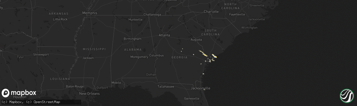
Hail Map in Georgia on May 19, 2024
The weather event in Georgia on May 19, 2024 includes Hail, Wind, and Tornado maps. 16 states and 1,010 cities were impacted and suffered possible damage. The total estimated number of properties impacted is 536.
Want more than just the map?
Turn this storm into a full workflow.
- Owner + property data so you know who to knock
- OnDemand branded weather history reports to win the "did we even have hail?" argument
- RoofTrace estimate so reps stop guessing numbers at the door
Bought this map? Upgrade within 7 days and we'll credit the $230. (10-15 min setup call)
Hail
Wind
Tornado
536
Estimated number of impacted properties by a 1.00" hail or larger0
Estimated number of impacted properties by a 1.75" hail or larger0
Estimated number of impacted properties by a 2.50" hail or largerStorm reports in Georgia
Georgia
| Date | Description |
|---|---|
| 05/19/20241:10 PM CDT | Effingham county emergency management reported two trees down on union springs road. One fell into powerlines and caused a small fire by the roadway. |
| 05/19/20241:08 PM CDT | Effingham county emergency management reported a pine tree down across bethany road. |
| 05/19/20241:07 PM CDT | Effingham county emergency management reported an oak tree about 3 feet in diameter was blown down on whitaker road. |
| 05/19/20241:05 PM CDT | Effingham county emergency management reported several areas along stillwell clyo road where power poles were broken... Trees and powerlines were down... And two 80 acr |
| 05/19/202412:55 PM CDT | Dime to quarter-sized hail reported at dollar general store. |
| 05/19/202412:55 PM CDT | Effingham county emergency management relayed report of ping pong ball size hail in clyo. |
| 05/19/202412:47 PM CDT | Effingham county warning point reported a tree down on shawnee egypt road. |
| 05/19/202412:47 PM CDT | Effingham county emergency management reported multiple trees around 12 inches in diameter were down across savannah town road. |
| 05/19/202412:45 PM CDT | Effingham county warning point reported a tree down at egypt ardmore road and savannah town road. |
| 05/19/202412:15 PM CDT | Single tree down along the 3000 block of hwy 242 per 911 center. |
| 05/19/202411:43 AM CDT | Tree reported down on twin oaks road. Time is radar estimated. |
| 05/19/202411:33 AM CDT | Media relayed report and video of quarter size hail in sylvania. |
All States Impacted by Hail Map on May 19, 2024
Cities Impacted by Hail Map on May 19, 2024
- Hayes Center, NE
- Weeping Water, NE
- Louisville, NE
- Avoca, NE
- Manley, NE
- Murray, NE
- Nehawka, NE
- Gove, KS
- McCook, NE
- Nebraska City, NE
- Park, KS
- Plattsmouth, NE
- Beeler, KS
- Oberlin, KS
- Danbury, NE
- Quinter, KS
- Pacific Junction, IA
- Otoe, NE
- Ransom, KS
- Ness City, KS
- Jennings, KS
- Dresden, KS
- Selden, KS
- Rexford, KS
- Hoxie, KS
- Clayton, KS
- Norcatur, KS
- Morland, KS
- Norton, KS
- Lenora, KS
- Hill City, KS
- Sandersville, GA
- Irwinton, GA
- Toomsboro, GA
- Greenfield, IA
- Sylvania, GA
- Orient, IA
- Fontanelle, IA
- Stuart, IA
- Garland, NE
- Seward, NE
- Bee, NE
- Malcolm, NE
- Pleasant Dale, NE
- Valparaiso, NE
- Raymond, NE
- Lincoln, NE
- Davey, NE
- Waverly, NE
- Winterset, IA
- Dexter, IA
- Fort Pierce, FL
- Greenwood, NE
- Alvo, NE
- Murdock, NE
- Earlham, IA
- Macksburg, IA
- Newington, GA
- Okeechobee, FL
- Twin City, GA
- Metter, GA
- Vero Beach, FL
- Beaufort, SC
- Lake Placid, FL
- Arcadia, FL
- Seabrook, SC
- Sebring, FL
- Clyo, GA
- Lebanon, NE
- Springfield, GA
- Penokee, KS
- Saint Helena Island, SC
- Port Saint Lucie, FL
- Lorida, FL
- Beaver City, NE
- Indianola, IA
- Prole, IA
- Oxford, NE
- Tillman, SC
- Hardeeville, SC
- Almena, KS
- Long Island, KS
- Jensen Beach, FL
- Wakeeney, KS
- Utica, KS
- Stamford, NE
- Phillipsburg, KS
- Prairie View, KS
- Logan, KS
- Alma, NE
- Orleans, NE
- Ogallah, KS
- Ellis, KS
- Hilton Head Island, SC
- Kenansville, FL
- Holdrege, NE
- Atlanta, NE
- Indiantown, FL
- Republican City, NE
- Stuart, FL
- Naponee, NE
- Fellsmere, FL
- Palm City, FL
- Hays, KS
- Dix, NE
- Savannah, GA
- Pooler, GA
- Bloomingdale, GA
- Sebastian, FL
- Palm Bay, FL
- Bayard, NE
- Minatare, NE
- Kensington, KS
- Agra, KS
- Daufuskie Island, SC
- Bluffton, SC
- Canal Point, FL
- Victoria, KS
- Melbourne Beach, FL
- Grant, FL
- Loxahatchee, FL
- Palm Beach Gardens, FL
- Jupiter, FL
- West Palm Beach, FL
- Hot Springs, SD
- Potter, NE
- Fort Stewart, GA
- Plainville, KS
- Alliance, NE
- Gorham, KS
- Smith Center, KS
- Angora, NE
- Tybee Island, GA
- Sidney, NE
- Campo, CO
- Catharine, KS
- Natoma, KS
- Walker, KS
- Paradise, KS
- Russell, KS
- Riverton, NE
- Inavale, NE
- Walsh, CO
- La Crosse, KS
- Otis, KS
- Bison, KS
- Hemingford, NE
- North Palm Beach, FL
- Red Cloud, NE
- Peetz, CO
- Arriba, CO
- Rolla, KS
- Miami, TX
- Pleasantville, IA
- Iliff, CO
- Knoxville, IA
- Swan, IA
- Waldo, KS
- Runnells, IA
- Lakin, KS
- Monroe, IA
- Johnson, KS
- Bloomington, NE
- Prairie City, IA
- Luray, KS
- Bunker Hill, KS
- Lucas, KS
- Deerfield, KS
- Pine Ridge, SD
- Oglala, SD
- Richfield, KS
- Otley, IA
- Guide Rock, NE
- Blue Hill, NE
- Hugoton, KS
- Crook, CO
- Dorrance, KS
- Sylvan Grove, KS
- Fleming, CO
- Haxtun, CO
- Wilson, KS
- Fisher, IL
- Dewey, IL
- Pahokee, FL
- Pella, IA
- Reasnor, IA
- De Land, IL
- Canadian, TX
- Brunswick, GA
- Manderson, SD
- Custer, SD
- Pringle, SD
- Brookston, IN
- Ann Arbor, MI
- Lynnville, IA
- Utica, MI
- Washington, MI
- Rochester, MI
- Sully, IA
- Weldon, IL
- Saint Simons Island, GA
- Ellsworth, KS
- Lincoln, KS
- Holcomb, KS
- Garden City, KS
- New Sharon, IA
- Montezuma, IA
- Leighton, IA
- Hermosa, SD
- Fairburn, SD
- Mahomet, IL
- Rantoul, IL
- Atlanta, IL
- McLean, IL
- Hoopeston, IL
- Hoisington, KS
- Macomb, MI
- Liberal, KS
- Greenview, IL
- Chalmers, IN
- Remington, IN
- Satanta, KS
- Ulysses, KS
- Pierceville, KS
- Sublette, KS
- Kismet, KS
- Plains, KS
- Ingalls, KS
- Harrison Township, MI
- Clinton Township, MI
- New Baltimore, MI
- Sterling Heights, MI
- Armington, IL
- Athens, IL
- Wolcott, IN
- Lawrence, NE
- Fowler, IN
- Higgins, TX
- Richmond, MI
- Cimarron, KS
- Scott City, KS
- What Cheer, IA
- Barnes City, IA
- Meade, KS
- Tescott, KS
- Beverly, KS
- Kanopolis, KS
- Brookville, KS
- Salina, KS
- Porcupine, SD
- Rossville, IL
- Troy, MI
- Arnett, OK
- Henning, IL
- Alvin, IL
- Keystone, SD
- Saline, MI
- Jetmore, KS
- Dighton, KS
- Healy, KS
- Lindsborg, KS
- Minneola, KS
- Ensign, KS
- Dodge City, KS
- Wright, KS
- Fowler, KS
- Danville, IL
- Gibson, IA
- Leoti, KS
- Barnard, KS
- Durham, OK
- Buffalo Gap, SD
- Otis, CO
- Hobe Sound, FL
- Bennington, KS
- Englewood, KS
- Ford, KS
- Hanston, KS
- Spearville, KS
- Rapid City, SD
- Beloit, KS
- Keswick, IA
- Winona, KS
- Tuscola, IL
- Camargo, IL
- Wanblee, SD
- New Cambria, KS
- Minneapolis, KS
- Kinsley, KS
- Offerle, KS
- Bucklin, KS
- Mullinville, KS
- Greensburg, KS
- Ashland, KS
- Hayes, SD
- Fort Pierre, SD
- Midland, SD
- New Underwood, SD
- Owanka, SD
- Wasta, SD
- Wall, SD
- Akron, CO
- Gould, OK
- Hollis, OK
- Crawford, OK
- Caputa, SD
- Catlin, IL
- Oakwood, IL
- Claflin, KS
- Allen, SD
- Tolono, IL
- Williamsport, IN
- Quinn, SD
- Cheyenne, OK
- Eagle Butte, SD
- Solomon, KS
- Gypsum, KS
- Assaria, KS
- Abilene, KS
- Protection, KS
- Haviland, KS
- Lewis, KS
- Belpre, KS
- Macksville, KS
- Larned, KS
- Burdett, KS
- Garfield, KS
- Warren, MI
- Dupree, SD
- Detroit, MI
- Marquette, KS
- Geneseo, KS
- Claypool, IN
- Silver Lake, IN
- Lorraine, KS
- Falun, KS
- Holyrood, KS
- Delphos, KS
- Madison Heights, MI
- Ponte Vedra Beach, FL
- Hammon, OK
- Leedey, OK
- Coldwater, KS
- Wilmore, KS
- Byers, KS
- Pratt, KS
- Crete, NE
- Hallam, NE
- Martell, NE
- Roca, NE
- Sprague, NE
- Hickman, NE
- Gettysburg, SD
- Wallace, KS
- Mangum, OK
- Willow, OK
- Akron, IN
- West Lebanon, IN
- Westville, IL
- Timber Lake, SD
- Covington, IN
- Hindsboro, IL
- Edson, KS
- Kadoka, SD
- Milesville, SD
- Philip, SD
- Butler, OK
- Hope, KS
- Talmage, KS
- Chapman, KS
- Enterprise, KS
- Sun City, KS
- Coats, KS
- Turon, KS
- St John, KS
- Sawyer, KS
- Iuka, KS
- Hudson, KS
- Stafford, KS
- Great Bend, KS
- Pawnee Rock, KS
- Iowa Falls, IA
- Steamboat Rock, IA
- Mcpherson, KS
- Little River, KS
- Olmitz, KS
- Windom, KS
- State Line, IN
- Bismarck, IL
- Okatie, SC
- Granite, OK
- Woodbine, KS
- Monument, KS
- Brewster, KS
- Medicine Lodge, KS
- Cunningham, KS
- Ellinwood, KS
- Isabel, KS
- Sylvia, KS
- Ramona, KS
- Herington, KS
- Wellsburg, IA
- Holland, IA
- Vici, OK
- Bushton, KS
- Lone Wolf, OK
- Tampa, KS
- Canton, KS
- Durham, KS
- Selfridge, ND
- Cherry Creek, SD
- Sentinel, OK
- Humboldt, NE
- Galva, KS
- Roxbury, KS
- Lehigh, KS
- Custer City, OK
- Okaton, SD
- Rocky, OK
- Cordell, OK
- Hillsboro, KS
- Lincolnville, KS
- Marion, KS
- Lost Springs, KS
- Junction City, KS
- White City, KS
- Colby, KS
- Dill City, OK
- Stella, NE
- Dike, IA
- Grundy Center, IA
- Parkersburg, IA
- Lyons, KS
- Raymond, KS
- Chase, KS
- Pawnee City, NE
- Taloga, OK
- Partridge, KS
- Nashville, KS
- Plevna, KS
- Sterling, KS
- Alden, KS
- Hutchinson, KS
- Arlington, KS
- Kingman, KS
- Pretty Prairie, KS
- Abbyville, KS
- Nickerson, KS
- Solen, ND
- Inman, KS
- Burdick, KS
- Moundridge, KS
- Spivey, KS
- Zenda, KS
- Murdock, KS
- Haven, KS
- South Hutchinson, KS
- McLaughlin, SD
- Walker, SD
- Wakpala, SD
- Newton, KS
- Goessel, KS
- Wilsey, KS
- Council Grove, KS
- Reinbeck, IA
- Cedar Falls, IA
- Shubert, NE
- Auburn, NE
- Nemaha, NE
- Clay Center, KS
- Cheney, KS
- Mount Hope, KS
- Burrton, KS
- Buhler, KS
- Putnam, OK
- Clinton, OK
- Arapaho, OK
- Bentley, KS
- Halstead, KS
- Hesston, KS
- Garden Plain, KS
- Peabody, KS
- Walton, KS
- Sedgwick, KS
- Colwich, KS
- North Newton, KS
- Andale, KS
- Dwight, KS
- Waterloo, IA
- Valley Center, KS
- Goddard, KS
- Norwich, KS
- Maize, KS
- Weatherford, OK
- Thomas, OK
- Miltonvale, KS
- Haigler, NE
- McDonald, KS
- Eldora, IA
- Gotebo, OK
- Rock Port, MO
- Oakley, KS
- Decatur, IL
- Mt Zion, IL
- Alta Vista, KS
- Elmdale, KS
- Strong City, KS
- Clarinda, IA
- Cedar Point, KS
- Florence, KS
- Whitewater, KS
- Wichita, KS
- Viola, KS
- Clearwater, KS
- Stryker, OH
- Bryan, OH
- Parks, NE
- Ney, OH
- Sherwood, OH
- Tarkio, MO
- Mandan, ND
- Champaign, IL
- Elbing, KS
- Benton, KS
- Kechi, KS
- Potwin, KS
- Greenwich, KS
- Geary, OK
- Watonga, OK
- Pierre, SD
- Agar, SD
- Onida, SD
- Murdo, SD
- Hazelton, ND
- Bismarck, ND
- Whitehorse, SD
- Saint Francis, KS
- Bird City, KS
- Coin, IA
- New Market, IA
- Nodaway, IA
- Essex, IA
- Villisca, IA
- Yorktown, IA
- Mooreland, OK
- Westboro, MO
- West Unity, OH
- Benkelman, NE
- Haysville, KS
- Derby, KS
- Augusta, KS
- Andover, KS
- El Dorado, KS
- Mcconnell Afb, KS
- Rose Hill, KS
- Towanda, KS
- Burns, KS
- Hydro, OK
- Greenfield, OK
- Hinton, OK
- Edgerton, OH
- Clearmont, MO
- Elmo, MO
- Corning, IA
- Pollock, SD
- Gravity, IA
- Sidney, IA
- Farragut, IA
- Alma, KS
- Allen, KS
- Emporia, KS
- Cottonwood Falls, KS
- Matfield Green, KS
- Cassoday, KS
- Rosalia, KS
- Douglass, KS
- Leon, KS
- Calumet, OK
- Eureka, KS
- Okarche, OK
- Moffit, ND
- Trail City, SD
- Glencross, SD
- Braddyville, IA
- Bedford, IA
- Olpe, KS
- Bennet, NE
- Walton, NE
- Chester, OK
- Firth, NE
- Hamilton, KS
- Madison, KS
- Latham, KS
- Piedmont, KS
- Beaumont, KS
- Atlanta, KS
- Mulvane, KS
- Shenandoah, IA
- Hopkins, MO
- Red Oak, IA
- Severy, KS
- Liberty Center, OH
- Wakefield, KS
- Waynoka, OK
- Hartford, KS
- Americus, KS
- El Reno, OK
- Union City, OK
- Menlo, IA
- Casey, IA
- Swanton, OH
- Buffalo, OK
- Lenox, IA
- Sharpsburg, IA
- Cerro Gordo, IL
- Howard, KS
- Fall River, KS
- Virgil, KS
- Neal, KS
- Toronto, KS
- Fredonia, KS
- Yates Center, KS
- Gridley, KS
- Neosho Falls, KS
- Burlington, KS
- Le Roy, KS
- Westphalia, KS
- Neosho Rapids, KS
- Waverly, KS
- Reading, KS
- Lebo, KS
- Melvern, KS
- Osage City, KS
- Woodward, OK
- Unadilla, NE
- Syracuse, NE
- Palmyra, NE
- Elmwood, NE
- Freedom, OK
- Aline, OK
- Clearfield, IA
- Fort Supply, OK
- Yukon, OK
- Mustang, OK
- Carmen, OK
- Bringhurst, IN
- Burlington, IN
- Cutler, IN
- Alva, OK
- Fairview, OK
- Humboldt, KS
- Buffalo, KS
- Piqua, KS
- Kincaid, KS
- Moran, KS
- Colony, KS
- La Harpe, KS
- Iola, KS
- Welda, KS
- Garnett, KS
- Richmond, KS
- Princeton, KS
- Ottawa, KS
- Williamsburg, KS
- Quenemo, KS
- Greeley, KS
- Pomona, KS
- Overbrook, KS
- Lyndon, KS
- Vassar, KS
- Auburn, KS
- Carbondale, KS
- Scranton, KS
- Admire, KS
- Wakarusa, KS
- Burlingame, KS
- Harveyville, KS
- Eskridge, KS
- Oklahoma City, OK
- Bethany, OK
- McIntosh, SD
- Lebanon, SD
- Diagonal, IA
- Helena, OK
- College Springs, IA
- Blanchard, IA
- Burlington Junction, MO
- Wheatland, OK
- Chanute, KS
- Benedict, KS
- Elsmore, KS
- Blue Mound, KS
- Lane, KS
- Mapleton, KS
- Bronson, KS
- Parker, KS
- Centerville, KS
- Silver Lake, KS
- Berryton, KS
- Topeka, KS
- Rantoul, KS
- Tecumseh, KS
- Wellsville, KS
- Lawrence, KS
- Mound City, KS
- Baldwin City, KS
- Osawatomie, KS
- Hague, ND
- Strasburg, ND
- Ames, OK
- Ringwood, OK
- Isabella, OK
- Highmore, SD
- Hartford, IA
- Argenta, IL
- Goltry, OK
- Meno, OK
- Kimball, SD
- Choctaw, OK
- Spencer, OK
- Lahoma, OK
- Leon, IA
- Van Wert, IA
- Decatur, IA
- Carrier, OK
- Nash, OK
- Enid, OK
- Oskaloosa, KS
- Perry, KS
- Mayetta, KS
- Hoyt, KS
- Grantville, KS
- Meriden, KS
- Denison, KS
- Holton, KS
- Ozawkie, KS
- Lecompton, KS
- Valley Falls, KS
- Raymore, MO
- Bonner Springs, KS
- De Soto, KS
- Leawood, KS
- Edgerton, KS
- Winchester, KS
- Archie, MO
- Freeman, MO
- Linwood, KS
- McLouth, KS
- Fontana, KS
- Basehor, KS
- Tonganoxie, KS
- Belton, MO
- Olathe, KS
- Leavenworth, KS
- Stilwell, KS
- Gardner, KS
- Louisburg, KS
- Spring Hill, KS
- Paola, KS
- Shawnee, KS
- New Century, KS
- Pleasanton, KS
- Cleveland, MO
- Overland Park, KS
- Bucyrus, KS
- Peculiar, MO
- Lenexa, KS
- Harrisonville, MO
- Pleasant Hill, MO
- Amsterdam, MO
- Kansas City, MO
- Drexel, MO
- Eudora, KS
- La Cygne, KS
- Platte City, MO
- Nortonville, KS
- Grandview, MO
- Lansing, KS
- Kansas City, KS
- Easton, KS
- Mission, KS
- Prairie Village, KS
- Fort Leavenworth, KS
- Lees Summit, MO
- Cummings, KS
- Greenwood, MO
- Weston, MO
- Liberty, MO
- Farley, MO
- Independence, MO
- Atchison, KS
- Waldron, MO
- Effingham, KS
- Riverside, MO
- Blue Springs, MO
- Kearney, MO
- Smithville, MO
- Grain Valley, MO
- Milo, IA
- Drummond, OK
- New Virginia, IA
- Belvue, KS
- Cherokee, OK
- Jet, OK
- Newalla, OK
- Lorimor, IA
- Afton, IA
- Truro, IA
- Osceola, IA
- Murray, IA
- Kremlin, OK
- Thayer, IA
- Garber, OK
- Fairmont, OK
- Kingsville, MO
- East Lynne, MO
- Buckner, MO
- Lone Jack, MO
- Holden, MO
- Garden City, MO
- Oak Grove, MO
- Strasburg, MO
- Sibley, MO
- Missouri City, MO
- Bates City, MO
- Excelsior Springs, MO
- Camden Point, MO
- Edgerton, MO
- Dearborn, MO
- Trimble, MO
- Rushville, MO
- Agency, MO
- Everest, KS
- Troy, KS
- Saint Joseph, MO
- Faucett, MO
- Bendena, KS
- Gower, MO
- De Kalb, MO
- Lancaster, KS
- Muscotah, KS
- Bridgewater, IA
- Melcher Dallas, IA
- Weldon, IA
- Union, NE
- Conception Junction, MO
- Barnard, MO
- Guilford, MO
- Grand River, IA
- Massena, IA
- Cumberland, IA
- Barnum, IA
- Stanton, IA
- Anita, IA
- Thurman, IA
- Columbia, IA
- Carbon, IA
- Elliott, IA
- Fairfax, MO
- Dunbar, NE
- Shambaugh, IA
- Billings, OK
- Pond Creek, OK
- Bristow, IA
- Greene, IA
- King City, MO
- Darlington, MO
- Joy, IL
- New Boston, IL
- Dacoma, OK
- Hunter, OK
- Clare, IA
- Malcom, IA
- Searsboro, IA
- Grinnell, IA
- Illinois City, IL
- Covington, OK
- Webster, IA
- Gentry, MO
- Albany, MO
- Rose Hill, IA
- Chelsea, IA
- Elberon, IA
- Levasy, MO
- Centerview, MO
- Wellington, MO
- Odessa, MO
- Napoleon, MO
- Orrick, MO
- Holt, MO
- Plattsburg, MO
- Lathrop, MO
- Camden, MO
- Clutier, IA
- Muscatine, IA
- Wilton, IA
- Perry, OK
- Durant, IA
- Brooklyn, IA
- Victor, IA
- Ladora, IA
- North English, IA
- Williamsburg, IA
- Denver, MO
- Worth, MO
- Deep River, IA
- Stockton, IA
- Marengo, IA
- Saint Charles, IA
- Baxter, IA
- Lacona, IA
- New Liberty, IA
- Harrah, OK
- Lucas, IA
- Woodburn, IA
- Walcott, IA
- Newton, IA
- Wheatland, IA
- Oxford, IA
- Saint Marys, IA
- Homestead, IA
- Lost Nation, IA
- Calamus, IA
- Dixon, IA
- Grand Mound, IA
- Tipton, IA
- Mechanicsville, IA
- Burlington, OK
- Stillwater, OK
- Tama, IA
- Morrison, OK
- Stanwood, IA
- Glencoe, OK
- Pawnee, OK
- North Liberty, IA
- Riverside, IA
- Iowa City, IA
- Olin, IA
- Anamosa, IA
- Monticello, IA
- Medford, OK
- Coralville, IA
- Guthrie, OK
- Waukomis, OK
- Douglas, OK
- Edmond, OK
- Hennessey, OK
- Crescent, OK
- Solon, IA
- West Branch, IA
- Marshall, OK
- Maquoketa, IA
- Baldwin, IA
- Cleveland, OK
- Maramec, OK
- Jennings, OK
- Cascade, IA
- Mulhall, OK
- Clarence, IA
- Orlando, OK
- Terlton, OK
- Hominy, OK
- Yale, OK
- Osage, OK
- Bison, OK
- Coyle, OK
- Mannford, OK
- Prue, OK
- Perkins, OK
- Sand Springs, OK
- Skiatook, OK
- Meridian, OK
- Wellston, OK
- Carney, OK
- Owasso, OK
- Depew, OK
- Bristow, OK
- Luther, OK
- Tulsa, OK
- Sperry, OK
- Collinsville, OK
- Catoosa, OK
- Claremore, OK
- Sparks, OK
- Chandler, OK
- Stroud, OK
- Tryon, OK
- Davenport, OK
- Kellyville, OK
- Guernsey, IA
- Agra, OK
- Oxford Junction, IA
- Lowden, IA
- Adair, IA
- Prague, OK
- Drumright, OK
- Lookeba, OK
- Paden, OK
- Middle Amana, IA
- Amana, IA
- Ripley, OK
- Castle, OK
- Cushing, OK
- Okemah, OK
- Okmulgee, OK
- Morris, OK
- Haskell, OK
- Callao, MO
- McFall, MO
- Harlan, IA


