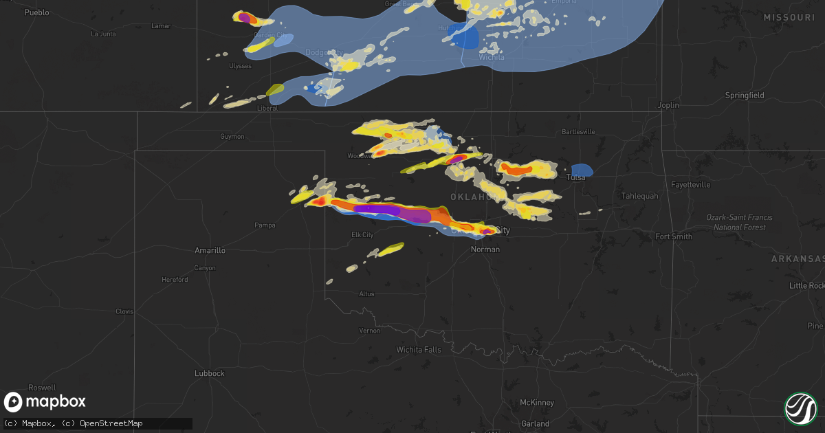
Hail Map on May 19, 2024
Get this storm
May 19 map
$229
one time, instant access
Download today. No call, no setup
Keep the $229
Bought the map and want the full workflow? Apply the entire $229 to a subscription within 7 days. None of it is wasted.
Every map, not just this one
This buys you this map. Subscription and you get every map we run, in the markets you choose from a few cities to whole states to nationwide. Plus real-time alerts the moment a storm fires.
Contact data
Name, contact info, occupancy, even credit band for addresses in the footprint. You go from where it hit to who to call.
Become the source they trust
Unlimited branding weather history reports on demand. You already have the documented answer ready for the property owner, and you are the one who showed up with it.
Property data and RoofTrace estimates
Pull up any address you have got, its value and the exact code rules for that jurisdiction, straight from One Click Code. Then RoofTrace estimates the squares, pitch, and roof value, priced the way you price.
States Impacted by Hail Map on May 19, 2024
Storm reports
Michigan
| Date | Description |
|---|---|
| 05/19/20245:30 PM CDT | Quarter sized hail near john r rd and e square lake rd. |
| 05/19/20245:25 PM CDT | Lots of dime sized hail and one stone to 1 inch near auburn rd and grant rd in rochester hills. |
| 05/19/20244:40 PM CDT | Spotter reported quarter sized hail in shelby township. |
South Dakota
| Date | Description |
|---|---|
| 05/19/20246:56 PM CDT | A local report indicates 80 MPH wind near 9 NE Kirley |
| 05/19/20246:56 PM CDT | A local report indicates 80 MPH wind near 6 ENE Kirley |
| 05/19/20246:55 PM CDT | A local report indicates 70 MPH wind near 6 NE Ottumwa |
| 05/19/20246:54 PM CDT | A local report indicates 65 MPH wind near 9 SE Kirley |
| 05/19/20246:53 PM CDT | A local report indicates 62 MPH wind near 1 NE Midland |
| 05/19/20246:48 PM CDT | Nickel to quarter. |
| 05/19/20246:44 PM CDT | A local report indicates 70 MPH wind near 10 NNW Ottumwa |
| 05/19/20246:34 PM CDT | A local report indicates 70 MPH wind near 10 NNW Ottumwa |
| 05/19/20246:28 PM CDT | A local report indicates 66 MPH wind near 3 E Philip |
| 05/19/20246:25 PM CDT | A local report indicates 60 MPH wind near 16 NW Philip |
| 05/19/20246:25 PM CDT | A local report indicates 58 MPH wind near 6 W Cottonwood |
| 05/19/20246:15 PM CDT | A local report indicates 62 MPH wind near 6 W Cottonwood |
| 05/19/20246:00 PM CDT | A local report indicates 60 MPH wind near 7 ENE Wasta |
| 05/19/20245:52 PM CDT | And nickel to quarter-sized hail. |
| 05/19/20245:44 PM CDT | A local report indicates 62 MPH wind near 3 NW Wasta |
| 05/19/20245:35 PM CDT | A local report indicates 60 MPH wind near 15 SSW Red Shirt |
| 05/19/20245:32 PM CDT | Cottonwood tree branches down in the yard. Thunderstorm wind gusts estimated at 70 to 80 mph. |
| 05/19/20244:40 PM CDT | A local report indicates 60 MPH wind near 7 W Hermosa |
| 05/19/20244:30 PM CDT | A local report indicates 60 MPH wind near Pringle |
| 05/19/20244:30 PM CDT | A local report indicates 60 MPH wind near 1 ENE Custer |
| 05/19/20244:05 PM CDT | A local report indicates 60 MPH wind near Oglala |
| 05/19/20243:52 PM CDT | A local report indicates 60 MPH wind near Pine Ridge |
| 05/18/20247:24 PM CDT | Nickel to quarter. |
| 05/18/20247:15 PM CDT | 50 to 60 mph winds. |
| 05/18/20247:15 PM CDT | Mesonet station 202 hayes |
| 05/18/20247:08 PM CDT | A local report indicates 66 MPH wind near 1 NE Midland |
| 05/18/20247:04 PM CDT | Mesonet station 168 foster bay |
| 05/18/20247:03 PM CDT | A local report indicates 62 MPH wind near 1 NE Midland |
| 05/18/20247:00 PM CDT | A local report indicates 60 MPH wind near 7 ESE Ottumwa |
North Dakota
| Date | Description |
|---|---|
| 05/18/20248:12 PM CDT | Pea size hail. |
| 05/18/20247:35 PM CDT | Hail encountered while driving north... Had to turn around. |
| 05/18/20247:20 PM CDT | Hail lasted from 715 to 725 pm. Wind gusts to 50 mph. |
| 05/18/20247:17 PM CDT | Estimated size from picture relayed via broadcast media. Time estimated via radar. |
| 05/18/20247:15 PM CDT | Hail lasted from 715 to 730 with wind gusts estimated at 60 mph. |
Oklahoma
| Date | Description |
|---|---|
| 05/19/20246:57 PM CDT | Report from mping: baseball |
| 05/19/20246:12 PM CDT | A local report indicates 75 MPH wind near 4 SE Roll |
| 05/19/20245:45 PM CDT | Delayed report. Report from mping: ping pong ball |
| 05/19/20242:47 AM CDT | Several large tree limbs down. |
| 05/19/20242:46 AM CDT | A local report indicates 59 MPH wind near 5 NNE Tulsa |
| 05/19/202412:15 AM CDT | Alva regional airport |
| 05/19/202412:15 AM CDT | Cherokee |
| 05/18/202411:40 PM CDT | Powerlines down along with damage to a barn in the vicinity. Radar estimated time. |
| 05/18/202410:56 PM CDT | Report from mping: quarter |
| 05/18/202410:56 PM CDT | Report from mping: golf ball |
| 05/18/202410:52 PM CDT | Report from mping: golf ball |
| 05/18/202410:47 PM CDT | Report from mping: ping pong ball |
| 05/18/202410:47 PM CDT | Report from mping: golf ball |
| 05/18/202410:45 PM CDT | Relayed images. Radar estimated time. |
| 05/18/202410:45 PM CDT | Spotter network report. |
| 05/18/202410:44 PM CDT | Relayed images. |
| 05/18/202410:43 PM CDT | Nwschat report. |
| 05/18/202410:38 PM CDT | Report from mping: half dollar |
| 05/18/202410:35 PM CDT | Nwschat report. |
| 05/18/202410:35 PM CDT | Report from mping: quarter |
| 05/18/202410:29 PM CDT | Report from mping: quarter |
| 05/18/202410:28 PM CDT | Report from mping: quarter |
| 05/18/202410:28 PM CDT | Report from mping: quarter |
| 05/18/202410:26 PM CDT | Delayed report. Report from mping: quarter |
| 05/18/202410:20 PM CDT | Relayed images. Digital caliper measurement. |
| 05/18/202410:18 PM CDT | Delayed report. Report from mping: quarter |
| 05/18/202410:10 PM CDT | A local report indicates 75 MPH wind near 6 SW Oklahoma City |
| 05/18/202410:09 PM CDT | Brief tornado. |
| 05/18/202410:06 PM CDT | Delayed report. Report from mping: half dollar |
| 05/18/202410:06 PM CDT | A local report indicates 1.50 inch wind near 4 E Yukon |
| 05/18/202410:05 PM CDT | Delayed report. Report from mping: quarter |
| 05/18/202410:01 PM CDT | Delayed report. Report from mping: quarter |
| 05/18/202410:00 PM CDT | Delayed report. Report from mping: quarter |
| 05/18/20249:53 PM CDT | Delayed report. Report from mping: quarter |
| 05/18/20249:51 PM CDT | A local report indicates a tornado near 4 SSE El Reno |
| 05/18/20249:45 PM CDT | A local report indicates 2.25 inch wind near Yukon |
| 05/18/20249:43 PM CDT | A local report indicates 1.25 inch wind near Yukon |
| 05/18/20249:37 PM CDT | Radar confirmed and media video. |
| 05/18/20249:33 PM CDT | Delayed report. Report from mping: half dollar |
| 05/18/20249:21 PM CDT | A local report indicates 2.25 inch wind near 5 NE Mooreland |
| 05/18/20249:20 PM CDT | A local report indicates 58 MPH wind near 5 WNW El Reno |
| 05/18/20248:40 PM CDT | Billboard blown down and semi-trailer turned over. |
| 05/18/20248:20 PM CDT | Delayed report. Damage to barns... 2 homes and granaries in the vicinity. Radar estimated time. |
| 05/18/20248:14 PM CDT | Delayed report. Report from mping: half dollar |
| 05/18/20248:11 PM CDT | Tree damage and power poles down. Possible tornado. |
| 05/18/20248:10 PM CDT | A local report indicates a tornado near 6 SSE Weatherford |
| 05/18/20247:35 PM CDT | A local report indicates a tornado near 4 W Butler |
| 05/18/20247:28 PM CDT | A local report indicates 80 MPH wind near 6.5 E Butler |
| 05/18/20247:25 PM CDT | A local report indicates 78 MPH wind near 3 E Butler |
South Carolina
| Date | Description |
|---|---|
| 05/19/20243:04 PM CDT | Tree reported down on gloucester road... Hilton head island. |
| 05/19/20241:20 PM CDT | Spotter reported golf ball size hail on fripp island. |
| 05/19/20241:20 PM CDT | Quarter size hail reported by hunting island state park employee. |
| 05/19/202412:51 PM CDT | Two trees reported down near the penn center south of frogmore... Sc. |
| 05/19/202412:42 PM CDT | Quarter size hail reported in beaufort. Shredded leaves off trees. Hail lasted 12 minutes. |
| 05/19/202412:40 PM CDT | Social media report and picture of ping pong ball size hail on lady's island. |
| 05/19/202412:33 PM CDT | Beaufort county warning point reported a tree down at middle road and needlerush court. |
| 05/19/202412:27 PM CDT | Beaufort county warning point reported a tree down at brickyard point road and pleasant point drive. |
| 05/19/202412:22 PM CDT | A local report indicates 68 MPH wind near Marine Corps Air Statio |
Kansas
| Date | Description |
|---|---|
| 05/19/20246:55 PM CDT | A local report indicates 75 MPH wind near Iuka |
| 05/19/20246:54 PM CDT | Local em reports quarter to slightly larger hail in page city. |
| 05/19/20246:52 PM CDT | A local report indicates 1.50 inch wind near 3 WNW Abilene |
| 05/19/20246:52 PM CDT | A local report indicates 60 MPH wind near Ellinwood |
| 05/19/20246:51 PM CDT | A local report indicates 1.25 inch wind near 1 NW Abilene |
| 05/19/20246:50 PM CDT | 65-70 mph winds. Trees are bending over at times. |
| 05/19/20246:50 PM CDT | Awos station kptt pratt indust. |
| 05/19/20246:49 PM CDT | A local report indicates 1.00 inch wind near 2 W Abilene |
| 05/19/20246:49 PM CDT | A local report indicates 58 MPH wind near Great Bend Airport |
| 05/19/20246:45 PM CDT | A local report indicates 60 MPH wind near 2 ENE Great Bend |
| 05/19/20246:45 PM CDT | Trained spotter reports estimated 2 inch diameter hail in winona... Still ongoing. |
| 05/19/20246:45 PM CDT | Corrects previous hail report from winona. Video from reporting party looks to have 1.25 inch hail... But a lot of it. Ground turns white... But is not accumulating. |
| 05/19/20246:37 PM CDT | Retired nws employee reports quarter sized hail 3 e of edson on i-70. |
| 05/19/20246:23 PM CDT | A local report indicates 60 MPH wind near McCracken |
| 05/19/20246:23 PM CDT | A local report indicates 1.00 inch wind near 1 ESE Solomon |
| 05/19/20246:18 PM CDT | A local report indicates 1.00 inch wind near 5 ESE New Cambria |
| 05/19/20246:17 PM CDT | A local report indicates 65 MPH wind near 3 W Macksville |
| 05/19/20246:15 PM CDT | Kwch shared picture of hail larger than quarters. |
| 05/19/20246:15 PM CDT | Mesonet station gw0421 belpre. |
| 05/19/20246:05 PM CDT | Powerlines and trees are down in salina. |
| 05/19/20245:59 PM CDT | A local report indicates 100 MPH wind near Salina Airport |
| 05/19/20245:58 PM CDT | A local report indicates 1.50 inch wind near 5 S Bennington |
| 05/19/20245:57 PM CDT | A local report indicates 1.00 inch wind near Bucklin |
| 05/19/20245:57 PM CDT | A local report indicates 1.00 inch wind near 4 SE Bennington |
| 05/19/20245:55 PM CDT | A local report indicates 1.25 inch wind near Bucklin |
| 05/19/20245:54 PM CDT | A local report indicates 1.75 inch wind near 2 N Salina |
| 05/19/20245:53 PM CDT | Mesonet station up835 3.0 w kingsdown |
| 05/19/20245:53 PM CDT | Mesonet station up835 3.0 w kingsdown |
| 05/19/20245:50 PM CDT | A local report indicates 1.00 inch wind near 5 SSW Bennington |
| 05/19/20245:46 PM CDT | Ping pong size hail on state street just west of salina. |
| 05/19/20245:45 PM CDT | The wind was estimated at 70-80 mph from outflow ahead of incoming storms. A 16-18 inch round live tree broke off and fell on the house with only minor damage. There wa |
| 05/19/20245:45 PM CDT | A branch of 14 inches in circumference was blown down. Several other branches of a similar size were also on the ground. |
| 05/19/20245:40 PM CDT | Picture of what appears to be golf ball sized hail on x. |
| 05/19/20245:40 PM CDT | Powerlines and tree lines are down. Time is estimated from radar. |
| 05/19/20245:39 PM CDT | A local report indicates 90 MPH wind near 10 SE Fowler |
| 05/19/20245:38 PM CDT | A local report indicates 1.00 inch wind near Culver |
| 05/19/20245:37 PM CDT | A local report indicates 1.50 inch wind near 1 SSW Culver |
| 05/19/20245:37 PM CDT | Delayed report. |
| 05/19/20245:30 PM CDT | A local report indicates 60 MPH wind near Tescott |
| 05/19/20245:26 PM CDT | Asos station kddc dodge city regional airport. |
| 05/19/20245:25 PM CDT | Nickel to quarter sized hail in town. No wind damage found. |
| 05/19/20245:14 PM CDT | A local report indicates 1.00 inch wind near Wilson |
| 05/19/20245:07 PM CDT | A local report indicates 2.00 inch wind near 1 S Russell Airport |
| 05/19/20245:01 PM CDT | A local report indicates 61 MPH wind near 7 N Plains City |
| 05/19/20244:55 PM CDT | A local report indicates 1.50 inch wind near 6 S Dorrance |
| 05/19/20244:54 PM CDT | Asos station kgck garden city. |
| 05/19/20244:53 PM CDT | Spotter reported torrential rainfall. |
| 05/19/20244:50 PM CDT | Mesonet station gccop 1 sw garden city. |
| 05/19/20244:49 PM CDT | A local report indicates 60 MPH wind near 10 WSW Westfall |
| 05/19/20244:49 PM CDT | A local report indicates 1.00 inch wind near 10 WSW Westfall |
| 05/19/20244:48 PM CDT | Mesonet station up407 0.6 sw hayne |
| 05/19/20244:46 PM CDT | Dust being kicked up but believe it is rain wrapped. |
| 05/19/20244:23 PM CDT | A local report indicates a tornado near 4 SSE Wilson |
| 05/19/20244:19 PM CDT | A local report indicates 1.75 inch wind near Wilson |
| 05/19/20244:15 PM CDT | Awos station kuls ulysses. |
| 05/19/20244:12 PM CDT | Picture sent via x. |
| 05/19/20243:52 PM CDT | A local report indicates 70 MPH wind near Sylvan Grove |
| 05/19/20243:48 PM CDT | Spotter reported large trees being blown down. |
| 05/19/20243:47 PM CDT | A local report indicates 82 MPH wind near Russell Airport |
| 05/19/20243:45 PM CDT | Picture and video sent via x. |
| 05/19/20243:43 PM CDT | A local report indicates 70 MPH wind near Russell |
| 05/19/20243:42 PM CDT | A local report indicates 2.50 inch wind near Russell |
| 05/19/20243:42 PM CDT | A local report indicates 1.25 inch wind near Russell |
| 05/19/20243:30 PM CDT | Tree damage was observed. Delayed report. |
| 05/19/20243:27 PM CDT | Broadcast media reports tornado west of russell. |
| 05/19/20243:18 PM CDT | A local report indicates 1.00 inch wind near 1 SSW Victoria |
| 05/19/20243:18 PM CDT | Report from mping: ping pong ball |
| 05/19/20243:10 PM CDT | A local report indicates 2.25 inch wind near 1 SSE Hays |
| 05/19/20243:05 PM CDT | A local report indicates 2.50 inch wind near 1 W Hays |
| 05/19/20243:02 PM CDT | A local report indicates 2.25 inch wind near 3 WNW Munjor |
| 05/19/20243:01 PM CDT | A local report indicates 1.75 inch wind near Hays |
| 05/19/20243:00 PM CDT | A local report indicates 1.50 inch wind near 1 NW Hays |
| 05/19/20242:58 PM CDT | A local report indicates 1.75 inch wind near 3 SSW Hays |
| 05/19/20242:45 PM CDT | A local report indicates 2.50 inch wind near Ellis |
| 05/19/20242:35 PM CDT | A local report indicates 1.50 inch wind near 1 SSE Ellis |
| 05/19/20242:30 PM CDT | A local report indicates 3.00 inch wind near 1 ENE Ellis |
| 05/19/20242:25 PM CDT | A local report indicates 2.00 inch wind near Ellis |
| 05/19/20242:25 PM CDT | A local report indicates 1.75 inch wind near 2 WNW Ellis |
| 05/19/20242:00 PM CDT | A local report indicates 1.00 inch wind near 6 E Trego Center |
| 05/19/20242:00 PM CDT | A local report indicates 1.00 inch wind near 6 E Trego Center |
| 05/18/202410:53 PM CDT | A local report indicates 60 MPH wind near 2 SE Pauline |
| 05/18/202410:51 PM CDT | Tree down and blocking highway. |
| 05/18/202410:49 PM CDT | 36-inch diameter tree snapped at the base. Tree fell on car. No injuries. Time estimated from radar. |
| 05/18/202410:49 PM CDT | Delayed report. Social media photo of trees snapped in huron park. Time estimated from radar. |
| 05/18/202410:47 PM CDT | Delayed report. Downed tree at the va medical center. Time estimated from radar. |
| 05/18/202410:47 PM CDT | Widespread power outages in the kck area. Thousands of customers without power. Time estimated from radar. |
| 05/18/202410:47 PM CDT | Downed power lines and widespread power outages near lowell avenue. Time estimated from radar. |
| 05/18/202410:44 PM CDT | Downed power lines and power outages near 74th street. Time estimated from radar and dispatch report. |
| 05/18/202410:44 PM CDT | Significant damage to boat docks. Time estimated from radar. |
| 05/18/202410:44 PM CDT | Widespread power outages in the area. Time estimated from radar. |
| 05/18/202410:44 PM CDT | Report from mping: 3-inch tree limbs broken; power poles broken. Time adjusted from radar. |
| 05/18/202410:41 PM CDT | A local report indicates 70 MPH wind near Oskaloosa |
| 05/18/202410:41 PM CDT | Multiple social media reports of downed trees and wires in prairie village. Time estimated from radar. |
| 05/18/202410:39 PM CDT | Preliminary results of a nws damage survey have confirmed an ef-1 tornado occurred sunday night... May 19th... 2024 in northeastern johnson county kansas. Much of the p |
| 05/18/202410:39 PM CDT | Multiple trees down near 87th and riley streets. Time estimated from radar. |
| 05/18/202410:39 PM CDT | Downed trees and power lines near johnson drive and long avenue. Time estimated from radar. |
| 05/18/202410:39 PM CDT | Social media report of multiple trees down and property damage near 87th street and lowell avenue. Time estimated from radar. |
| 05/18/202410:39 PM CDT | Two large power poles downed near 187th and fairmount road. Time estimated from radar. |
| 05/18/202410:36 PM CDT | T |
| 05/18/202410:36 PM CDT | Social media report of downed trees and limbs near johnson drive. Time estimated from radar. |
| 05/18/202410:36 PM CDT | Time estimated from radar. |
| 05/18/202410:33 PM CDT | Downed power lines and power outages middle creek lake. Time estimated from radar. |
| 05/18/202410:33 PM CDT | Downed tree limbs near 64th and monticello. Time estimated from radar. |
| 05/18/202410:33 PM CDT | Asos station kixd olathe industria. |
| 05/18/202410:31 PM CDT | Delayed report. Several reports of downed trees south of louisburg. Time estimated from radar. |
| 05/18/202410:31 PM CDT | Preliminary results of a nws damage survey have confirmed an ef-1 tornado occurred monday night... May 19th... 2024... In northwestern johnson county kansas. The tornad |
| 05/18/202410:31 PM CDT | Several downed trees in tonganoxie. Time estimated from radar. |
| 05/18/202410:30 PM CDT | Via facebook. |
| 05/18/202410:30 PM CDT | Several reports of tree and property damage in the olathe area. Time estimated from radar. |
| 05/18/202410:28 PM CDT | Social media report of damage to the mill valley high school tennis court shelter. Time estimated from radar. |
| 05/18/202410:28 PM CDT | Delayed report. Social media photo of downed trees in de soto. Time estimated from radar. |
| 05/18/202410:28 PM CDT | Report from mping: 3-inch tree limbs broken; power poles broken. Time adjusted from radar. |
| 05/18/202410:25 PM CDT | Several reports of trees down and power outages in the linwood area. Time estimated from radar. |
| 05/18/202410:24 PM CDT | A local report indicates 60 MPH wind near 2 NE Dover |
| 05/18/202410:23 PM CDT | Delayed report. Social media photos of a tree uprooted... Falling onto a house. Time estimated from radar. |
| 05/18/202410:23 PM CDT | Social media report of trees and limbs down and property damage on 183rd street. Time estimated from radar. |
| 05/18/202410:20 PM CDT | Substantial damage to an apartment complex... With several trees down and roof and shingle damage. Time estimated from radar. |
| 05/18/202410:20 PM CDT | Reports of several large trees damaged. |
| 05/18/202410:20 PM CDT | Downed power lines and power outages near market street. Time estimated from radar. |
| 05/18/202410:20 PM CDT | Powerlines down on 56 hwy. |
| 05/18/202410:18 PM CDT | Time estimated by radar. |
| 05/18/202410:13 PM CDT | Power lines downed in the 800 block of e1500 road. |
| 05/18/202410:12 PM CDT | Delayed report. Social media photo of a tree downed onto a vehicle. Time estimated from radar. |
| 05/18/202410:11 PM CDT | A local report indicates 60 MPH wind near 3 S Lecompton |
| 05/18/202410:10 PM CDT | Power box broken by fallen tree. Time estimated by radar. |
| 05/18/202410:10 PM CDT | Downed power lines and power outages near pressonville road. Time estimated from radar. |
| 05/18/20249:55 PM CDT | Trees and 4 inch diameter limbs down in humboldt. |
| 05/18/20249:49 PM CDT | Reported from at home weather station. |
| 05/18/20249:48 PM CDT | Delayed report. Tree damage consistent with tornado damage. Time estimated from radar. End of path. |
| 05/18/20249:47 PM CDT | Roof blown off house. |
| 05/18/20249:45 PM CDT | A local report indicates 1.00 inch wind near 1 E Eskridge |
| 05/18/20249:44 PM CDT | Delayed report. Tree damage consistent with tornado damage. Time estimated from radar. |
| 05/18/20249:39 PM CDT | Reported sustained winds of 60 mph with gusts to 70 mph. |
| 05/18/20249:27 PM CDT | A local report indicates 60 MPH wind near 7 WSW Neosho Falls |
| 05/18/20249:13 PM CDT | A local report indicates 60 MPH wind near 1 NE Emporia |
| 05/18/20249:10 PM CDT | A local report indicates 60 MPH wind near 4 N Virgil |
| 05/18/20249:06 PM CDT | Measured by backyard weather station. |
| 05/18/20249:01 PM CDT | Reports of tree and power line damage in the city of emporia. |
| 05/18/20248:59 PM CDT | A local report indicates 64 MPH wind near 5 NNW Olpe |
| 05/18/20248:55 PM CDT | A local report indicates 60 MPH wind near Eureka Airport |
| 05/18/20248:36 PM CDT | Cedar tree blown over. Time is estimated from radar. |
| 05/18/20248:35 PM CDT | Measured at the airport. |
| 05/18/20248:34 PM CDT | 6 inch diameter tree damage. |
| 05/18/20248:33 PM CDT | One to two inch diameter tree limbs downed. |
| 05/18/20248:25 PM CDT | A local report indicates 60 MPH wind near El Dorado |
| 05/18/20248:25 PM CDT | A local report indicates 60 MPH wind near 3 W Augusta |
| 05/18/20248:21 PM CDT | 60 to 70 mph winds. ( |
| 05/18/20248:21 PM CDT | 60 to 70 mph winds. |
| 05/18/20248:20 PM CDT | A local report indicates 68 MPH wind near 3 SW Burns |
| 05/18/20248:18 PM CDT | Delayed report. Sporadic tree limbs down across the city. All limbs appear to be less than 5 inches in diameter. |
| 05/18/20248:18 PM CDT | Delayed report. On 20th street in burns... A 40 by 60 foot polebarn was taken down... And a chicken coop was blown into a hedge row. Time estimated from radar. |
| 05/18/20248:18 PM CDT | A local report indicates 60 MPH wind near Andover |
| 05/18/20248:13 PM CDT | 6 to 12 inch diameter tree limbs are reported down. |
| 05/18/20248:11 PM CDT | A local report indicates 1.75 inch wind near 3 W Peabody |
| 05/18/20248:11 PM CDT | Measured near 13th and webb. Courtesy of kake tv. |
| 05/18/20248:08 PM CDT | Extensive tree |
| 05/18/20248:08 PM CDT | Extensive tree damage in and around newton... Many roads blocked. Courtesy of accuweather. |
| 05/18/20248:06 PM CDT | Measured at jabara airport. |
| 05/18/20248:05 PM CDT | Power lines down. |
| 05/18/20248:04 PM CDT | Whitewater fire department estimates 70 to 80 mph winds. |
| 05/18/20248:03 PM CDT | Off duty nws employee had measurement of 72 mph. |
| 05/18/20248:02 PM CDT | Newton airport. |
| 05/18/20248:00 PM CDT | Delayed report. Roof blown off a metal outbuilding. |
| 05/18/20247:57 PM CDT | A local report indicates 70 MPH wind near 4 E Wilsey |
| 05/18/20247:55 PM CDT | A local report indicates 65 MPH wind near 4 N Hesston |
| 05/18/20247:55 PM CDT | Quarter sized hail and 65 mph winds reported. |
| 05/18/20247:55 PM CDT | Several power lines reported down in northwest wichita. |
| 05/18/20247:53 PM CDT | Davis weather station near 34th st. N and ridge rd. |
| 05/18/20247:47 PM CDT | A local report indicates 60 MPH wind near 5 NW Halstead |
| 05/18/20247:40 PM CDT | A local report indicates 80 MPH wind near 1 S Mount Hope |
| 05/18/20247:40 PM CDT | A local report indicates 86 MPH wind near Hutchinson Airport |
| 05/18/20247:37 PM CDT | Multiple power lines down as well as structural damage reported. Time based on other reports. |
| 05/18/20247:36 PM CDT | Kake reporting roof blown off of a building on south main street. |
| 05/18/20247:36 PM CDT | Kake weathernow network measures 70 mph winds. |
| 05/18/20247:35 PM CDT | Roofs blown off of homes. |
| 05/18/20247:25 PM CDT | Off duty nws employee reporting 60 mph winds. |
| 05/18/20247:25 PM CDT | Powerlines down in the 660 block of west hayes. |
| 05/18/20247:25 PM CDT | Lots of tree limbs in the roads and power is out to some of the town. |
| 05/18/20247:20 PM CDT | A local report indicates 1.25 inch wind near 7 WSW Mcpherson |
| 05/18/20247:16 PM CDT | Delayed report. Measured by kansas state mesonet site. |
| 05/18/20247:12 PM CDT | At least 70 mph winds... Could have been higher. Four inch diameter tree limbs down. |
| 05/18/20247:06 PM CDT | A local report indicates 70 MPH wind near 1 N Langdon |
| 05/18/20247:03 PM CDT | A local report indicates 1.50 inch wind near Hope |
| 05/18/20247:02 PM CDT | A local report indicates 60 MPH wind near Mcpherson |
| 05/18/20247:02 PM CDT | Power lines down. |
Illinois
| Date | Description |
|---|---|
| 05/19/20246:35 PM CDT | Pictures and video from social media indicated a brief landspout tornado in open fields. No damage has been reported. Times and location estimated. |
| 05/19/20244:45 PM CDT | Tree limb broken. Ded. Parts of tennis court fence knocked down. Flag pole at socc |
| 05/19/20244:45 PM CDT | Tree limb broken. |
| 05/18/20248:49 PM CDT | Relayed via broadcast media. Image of quarter sized hail in long creek. |
| 05/18/20248:45 PM CDT | Image of hailstone next to measuring device via social media at 121 and bentonville rd. |
| 05/18/20248:02 PM CDT | A local report indicates 58 MPH wind near Decatur Airport |
Florida
| Date | Description |
|---|---|
| 05/19/20245:37 PM CDT | Public report of quarter size hail near palm city. |
| 05/19/20243:15 PM CDT | Off duty nws employee reports quarter size hail near palm beach gardens. |
| 05/19/20242:30 PM CDT | Public reports one inch hail in floridana beach near the intersection of amigos rd and floridana ave. |
| 05/19/20242:18 PM CDT | Trained spotter reports 1.5 inch hail near se ocean blvd and se monterey rd in stuart. |
| 05/19/20242:17 PM CDT | Public report via social media with picture and video of golf ball size hail near edgewood dr. Hail lasted around 6 minutes. |
| 05/19/202412:41 PM CDT | Trained spotter reports half dollar sized hail near the intersection of virginia ave us 1 in fort pierce. |
| 05/19/202412:41 PM CDT | Corrects previous hail report from 1 ssw fort pierce. Picture of quarter sized hail near the intersection of virginia ave us 1 in fort pierce received from trained spot |
| 05/19/202412:00 PM CDT | St. Lucie county emergency management relayed report of hail between 1-2 inches in diameter near the intersection of n 13th street and avenue m in fort pierce. |
Iowa
| Date | Description |
|---|---|
| 05/19/20244:41 PM CDT | Measured wind speed of 59.3 mph. |
| 05/19/20244:11 PM CDT | Measured wind gust reported by the pella awos. Report time given is the same time as the metar. |
| 05/19/20243:35 PM CDT | Report with a photo of quarter sized hail in pleasantville. |
| 05/19/202411:55 AM CDT | A local report indicates 1.00 inch wind near Winterset |
| 05/19/20241:01 AM CDT | Broken lilac tree reported down. Time estimated from radar. |
| 05/19/202412:48 AM CDT | Report from mping: half dollar |
| 05/19/202412:48 AM CDT | A local report indicates 60 MPH wind near Hiawatha |
| 05/19/202412:47 AM CDT | Occurring right now. |
| 05/19/202412:36 AM CDT | 8 to 10 inch diameter healthy tree snapped. Time based on radar. |
| 05/19/202412:30 AM CDT | Trees down in tiffin. Time based on radar. |
| 05/18/202411:55 PM CDT | Corrects time of the previous hail report from durant. Received via social media. |
| 05/18/202411:51 PM CDT | Large tree branches along with damage to a shed at this location. |
| 05/18/202411:51 PM CDT | Received via social media. |
| 05/18/202411:30 PM CDT | Couple of trees and branches down in urbana. Time based on radar. |
| 05/18/202411:14 PM CDT | Several trees down in town. Time estimated by radar. |
| 05/18/20248:46 PM CDT | Report of quarter sized hail on stuart road south of stuart. Time and location estimated with radar. |
| 05/18/20248:36 PM CDT | Report of quarter sized hail near the intersection of highway 92 and henry a wallace road. Time estimated with radar. |
| 05/18/20248:05 PM CDT | A local report indicates 1.75 inch wind near 5 E Hepburn |
| 05/18/20248:05 PM CDT | Damage to trees. |
| 05/18/20247:55 PM CDT | A local report indicates 1.50 inch wind near 1 SE Clarinda |
| 05/18/20247:49 PM CDT | Report from mping: half dollar |
| 05/18/20247:47 PM CDT | Photo relayed via emergency management. Lasted about 3 minutes. Damage to cars. Time estimated from radar. |
| 05/18/20247:41 PM CDT | A local report indicates 58 MPH wind near Villisca |
| 05/18/20247:10 PM CDT | Quarter sized hail reported in dike. Photo and video relayed via broadcast media. Time estimated from radar. |
Utah
| Date | Description |
|---|---|
| 05/18/202411:52 PM CDT | Asos station kmlf milford municipal airport. |
Missouri
| Date | Description |
|---|---|
| 05/19/202412:26 AM CDT | Delayed report. Social media report of a tree and limbs down on crowder road. Time estimated from radar. |
| 05/19/202412:12 AM CDT | Social media report of a trailer overturned northeast of bogard. Time estimated from radar. |
| 05/18/202411:46 PM CDT | Downed power lines and power outages near route 116. Time estimated from radar. |
| 05/18/202411:43 PM CDT | Several reports of power outages in the cameron area. Time estimated from radar. |
| 05/18/202411:33 PM CDT | Delayed report. Social media photo of a downed tree at a residence in richmond. Time estimated from radar. |
| 05/18/202411:33 PM CDT | Several reports of power lines down and power outages near warrensburg. Time estimated from radar. |
| 05/18/202411:27 PM CDT | Downed power lines and power outages near east hills mall. Time estimated from radar. |
| 05/18/202411:22 PM CDT | Downed power lines and power outages near zay drive. Time estimated from radar. |
| 05/18/202411:19 PM CDT | Report from mping: 3-inch tree limbs broken; power poles broken. Time adjusted from radar. |
| 05/18/202411:19 PM CDT | Delayed report. Social media photos of downed trees near route 33 between kearney and holt. Time estimated from radar. |
| 05/18/202411:16 PM CDT | Delayed report. Flagpole snapped from strong winds in kingsville. Time estimated from radar. |
| 05/18/202411:13 PM CDT | Delayed report. Social media photo of a large downed tree at a residence north of grain valley. Time estimated from radar. |
| 05/18/202411:11 PM CDT | Delayed report. Social media photo of downed trees onto a house. Time estimated from radar. |
| 05/18/202411:11 PM CDT | Downed power lines and widespread power outages in urich. Time estimated from radar. |
| 05/18/202411:05 PM CDT | Several reports of power outages between pleasant hill and lone jack. Time estimated from radar. |
| 05/18/202411:05 PM CDT | Widespread power outages near roosterville airport and near 112th street. Time estimated from radar. |
| 05/18/202411:05 PM CDT | Widespread power outages in the creighton area. Time estimated from radar. |
| 05/18/202411:03 PM CDT | Delayed report. Social media photos of sporadic tree and limb damage in smithville. Time estimated from radar. |
| 05/18/202411:03 PM CDT | Downed power lines and power outages near hospital drive and near quincy boulevard in the smithville area. Time estimated from radar. |
| 05/18/202411:00 PM CDT | Downed power lines and power outages near hocker avenue. Time estimated from radar. |
| 05/18/202411:00 PM CDT | Delayed report. Several downed trees near noland and partridge. Time estimated from radar. |
| 05/18/202411:00 PM CDT | Delayed report. Several social media photos of tree damage in independence... Especially near 23rd street. Time estimated from radar. |
| 05/18/202411:00 PM CDT | Power outages in the area. |
| 05/18/202411:00 PM CDT | Downed trees and wires near noland road and 35th street. Time estimated from radar. |
| 05/18/202410:57 PM CDT | Downed power lines and power outages near oak street. Time estimated from radar. |
| 05/18/202410:57 PM CDT | Widespread power outages in ferrelview. Time estimated from radar. |
| 05/18/202410:57 PM CDT | Delayed report. Social media photos of downed trees and limbs near i-435 and shoal creek parkway. Time estimated from radar. |
| 05/18/202410:57 PM CDT | Delayed report. Downed trees and wires near brighton avenue. Time estimated from radar. |
| 05/18/202410:57 PM CDT | Delayed report. Social media photos of downed trees and limbs near hedgecock road. Time estimated from radar. |
| 05/18/202410:57 PM CDT | Delayed report. Strong winds broke house windows and downed limbs on the north side of lees summit. Time estimated from radar. |
| 05/18/202410:55 PM CDT | Downed trees and wires near ne 50th street. Time estimated from radar. |
| 05/18/202410:55 PM CDT | Delayed report. Several social media photos of trees down in gladstone. Time estimated from radar. |
| 05/18/202410:55 PM CDT | Delayed report. Downed trees and limbs on the southwest side of lees summit. Time estimated from radar. |
| 05/18/202410:55 PM CDT | Downed power lines and power outages near antioch road. Time estimated from radar. |
| 05/18/202410:55 PM CDT | Downed power lines and power outages near revere avenue. Time estimated from radar. |
| 05/18/202410:53 PM CDT | Estimated wind gusts of 75mph reported near the intersection of nw prairie view road and nw 79th terrace. Several trees and branches down with shingle damage reported. |
| 05/18/202410:53 PM CDT | Downed trees and property damage in the barry road area near i-29. Estimated gusts to 60 mph. Time confirmed from radar. |
| 05/18/202410:52 PM CDT | Delayed report. Social media photos of trees down in the briarcliff area. Time estimated from radar. |
| 05/18/202410:52 PM CDT | Downed power lines and power outages near 75th street. Time estimated from radar. |
| 05/18/202410:52 PM CDT | Delayed report. Several social media photos of damage between 74th street and 79th place. Time estimated from radar. |
| 05/18/202410:52 PM CDT | Delayed report. Social media photos of trees and limbs down near park hill high school. Time estimated from radar. |
| 05/18/202410:51 PM CDT | Asos at kmkc |
| 05/18/202410:49 PM CDT | Downed trees with some onto property. Time estimated from radar. |
| 05/18/202410:49 PM CDT | Delayed report. Downed tree limbs in several locations south of butler. Time estimated from radar. |
| 05/18/202410:49 PM CDT | Garage doors blown out of a building on kelly drive. Multiple trees and limbs down throughout the city of parkville. Time estimated from radar. |
| 05/18/202410:49 PM CDT | Delayed report. Social media photos of downed trees and limbs at a residence in harrisonville. Power outages also reported. Time estimated from radar. |
| 05/18/202410:47 PM CDT | Delayed report. Social media report of downed trees and wires near oak street. Time estimated from radar. |
| 05/18/202410:47 PM CDT | Downed trees and limbs along emanuel cleaver ii blvd near oak street. Time estimated from radar. |
| 05/18/202410:47 PM CDT | Multiple limbs down... Including on roads. Power is out in the area. Time estimated from radar. |
| 05/18/202410:47 PM CDT | Downed tree and wires at a residence in adrian. Time estimated from radar. |
| 05/18/202410:44 PM CDT | Downed power lines and power outages near woodland avenue. Time estimated from radar. |
| 05/18/202410:44 PM CDT | Downed power lines and power outages near woodbridge lane. Time estimated from radar. |
| 05/18/202410:44 PM CDT | Delayed report. Social media report of downed trees and limbs near harris avenue. Time estimated from radar. |
| 05/18/202410:44 PM CDT | Several reports of power outages near jerry smith park. Time estimated from radar. |
| 05/18/202410:41 PM CDT | Delayed report. Tree uprooted near cambridge road. Time estimated from radar. |
| 05/18/202410:36 PM CDT | Delayed report. Social media reports and photos of downed trees and limbs in cleveland. Time estimated from radar. |
| 05/18/202410:33 PM CDT | Downed power lines and power outages near route aa. Time estimated from radar. |
Colorado
| Date | Description |
|---|---|
| 05/19/20244:35 PM CDT | A local report indicates 1.75 inch wind near 2 SSW Dailey |
| 05/19/20244:28 PM CDT | Tornado ongoing... Location approximate. |
| 05/19/20244:15 PM CDT | A local report indicates a tornado near 1 SSE Fleming |
| 05/19/20244:15 PM CDT | A local report indicates 1.75 inch wind near Fleming |
| 05/19/20243:56 PM CDT | Just east of caliche school. Brief touchdown... Time estimated. |
| 05/19/20243:48 PM CDT | A local report indicates 1.00 inch wind near 4 WNW Proctor |
| 05/19/20242:12 PM CDT | Tornado on the ground... Beginning time estimated... On the ground at least 10 minutes. In open country... Damage unknown. |
Indiana
| Date | Description |
|---|---|
| 05/19/20245:00 PM CDT | Shingles blown off portion of a roof on a house in the 1100 block of e. Main street. Time approximated from radar. |
Nebraska
| Date | Description |
|---|---|
| 05/19/20245:37 PM CDT | A local report indicates 64 MPH wind near Martell |
| 05/19/20243:45 PM CDT | Report from mping: golf ball |
| 05/19/20243:19 PM CDT | Public report via social media. |
| 05/19/20247:19 AM CDT | Report from mping: quarter |
| 05/19/20247:00 AM CDT | Report from mping: quarter |
| 05/18/20247:38 PM CDT | Trained spotter reports golf ball sized hail. |
Georgia
| Date | Description |
|---|---|
| 05/19/20241:10 PM CDT | Effingham county emergency management reported two trees down on union springs road. One fell into powerlines and caused a small fire by the roadway. |
| 05/19/20241:08 PM CDT | Effingham county emergency management reported a pine tree down across bethany road. |
| 05/19/20241:07 PM CDT | Effingham county emergency management reported an oak tree about 3 feet in diameter was blown down on whitaker road. |
| 05/19/20241:05 PM CDT | Effingham county emergency management reported several areas along stillwell clyo road where power poles were broken... Trees and powerlines were down... And two 80 acr |
| 05/19/202412:55 PM CDT | Dime to quarter-sized hail reported at dollar general store. |
| 05/19/202412:55 PM CDT | Effingham county emergency management relayed report of ping pong ball size hail in clyo. |
| 05/19/202412:47 PM CDT | Effingham county emergency management reported multiple trees around 12 inches in diameter were down across savannah town road. |
| 05/19/202412:47 PM CDT | Effingham county warning point reported a tree down on shawnee egypt road. |
| 05/19/202412:45 PM CDT | Effingham county warning point reported a tree down at egypt ardmore road and savannah town road. |
| 05/19/202412:15 PM CDT | Single tree down along the 3000 block of hwy 242 per 911 center. |
| 05/19/202411:43 AM CDT | Tree reported down on twin oaks road. Time is radar estimated. |
| 05/19/202411:33 AM CDT | Media relayed report and video of quarter size hail in sylvania. |
Texas
| Date | Description |
|---|---|
| 05/19/20245:05 PM CDT | Hail size measured with a ruler and a photo was provided via social media. Time estimated based on radar data. |
| 05/19/20244:32 PM CDT | A local report indicates 1.25 inch wind near Canadian |
| 05/19/20243:58 PM CDT | A local report indicates 60 MPH wind near 1 NNW Stinnett |
Cities Impacted by Hail Map on May 19, 2024
- Hayes Center, NE
- Weeping Water, NE
- Louisville, NE
- Avoca, NE
- Manley, NE
- Murray, NE
- Nehawka, NE
- Gove, KS
- McCook, NE
- Nebraska City, NE
- Park, KS
- Plattsmouth, NE
- Beeler, KS
- Oberlin, KS
- Danbury, NE
- Quinter, KS
- Pacific Junction, IA
- Otoe, NE
- Ransom, KS
- Ness City, KS
- Jennings, KS
- Dresden, KS
- Selden, KS
- Rexford, KS
- Hoxie, KS
- Clayton, KS
- Norcatur, KS
- Morland, KS
- Norton, KS
- Lenora, KS
- Hill City, KS
- Sandersville, GA
- Irwinton, GA
- Toomsboro, GA
- Greenfield, IA
- Sylvania, GA
- Orient, IA
- Fontanelle, IA
- Stuart, IA
- Garland, NE
- Seward, NE
- Bee, NE
- Malcolm, NE
- Pleasant Dale, NE
- Valparaiso, NE
- Raymond, NE
- Lincoln, NE
- Davey, NE
- Waverly, NE
- Winterset, IA
- Dexter, IA
- Fort Pierce, FL
- Greenwood, NE
- Alvo, NE
- Murdock, NE
- Earlham, IA
- Macksburg, IA
- Newington, GA
- Okeechobee, FL
- Twin City, GA
- Metter, GA
- Vero Beach, FL
- Beaufort, SC
- Lake Placid, FL
- Arcadia, FL
- Seabrook, SC
- Sebring, FL
- Clyo, GA
- Lebanon, NE
- Springfield, GA
- Penokee, KS
- Saint Helena Island, SC
- Port Saint Lucie, FL
- Lorida, FL
- Beaver City, NE
- Indianola, IA
- Prole, IA
- Oxford, NE
- Tillman, SC
- Hardeeville, SC
- Almena, KS
- Long Island, KS
- Jensen Beach, FL
- Wakeeney, KS
- Utica, KS
- Stamford, NE
- Phillipsburg, KS
- Prairie View, KS
- Logan, KS
- Alma, NE
- Orleans, NE
- Ogallah, KS
- Ellis, KS
- Hilton Head Island, SC
- Kenansville, FL
- Holdrege, NE
- Atlanta, NE
- Indiantown, FL
- Republican City, NE
- Stuart, FL
- Naponee, NE
- Fellsmere, FL
- Palm City, FL
- Hays, KS
- Dix, NE
- Savannah, GA
- Pooler, GA
- Bloomingdale, GA
- Sebastian, FL
- Palm Bay, FL
- Bayard, NE
- Minatare, NE
- Kensington, KS
- Agra, KS
- Daufuskie Island, SC
- Bluffton, SC
- Canal Point, FL
- Victoria, KS
- Melbourne Beach, FL
- Grant, FL
- Loxahatchee, FL
- Palm Beach Gardens, FL
- Jupiter, FL
- West Palm Beach, FL
- Hot Springs, SD
- Potter, NE
- Fort Stewart, GA
- Plainville, KS
- Alliance, NE
- Gorham, KS
- Smith Center, KS
- Angora, NE
- Tybee Island, GA
- Sidney, NE
- Campo, CO
- Catharine, KS
- Natoma, KS
- Walker, KS
- Paradise, KS
- Russell, KS
- Riverton, NE
- Inavale, NE
- Walsh, CO
- La Crosse, KS
- Otis, KS
- Bison, KS
- Hemingford, NE
- North Palm Beach, FL
- Red Cloud, NE
- Peetz, CO
- Arriba, CO
- Rolla, KS
- Miami, TX
- Pleasantville, IA
- Iliff, CO
- Knoxville, IA
- Swan, IA
- Waldo, KS
- Runnells, IA
- Lakin, KS
- Monroe, IA
- Johnson, KS
- Bloomington, NE
- Prairie City, IA
- Luray, KS
- Bunker Hill, KS
- Lucas, KS
- Deerfield, KS
- Pine Ridge, SD
- Oglala, SD
- Richfield, KS
- Otley, IA
- Guide Rock, NE
- Blue Hill, NE
- Hugoton, KS
- Crook, CO
- Dorrance, KS
- Sylvan Grove, KS
- Fleming, CO
- Haxtun, CO
- Wilson, KS
- Fisher, IL
- Dewey, IL
- Pahokee, FL
- Pella, IA
- Reasnor, IA
- De Land, IL
- Canadian, TX
- Brunswick, GA
- Manderson, SD
- Custer, SD
- Pringle, SD
- Brookston, IN
- Ann Arbor, MI
- Lynnville, IA
- Utica, MI
- Washington, MI
- Rochester, MI
- Sully, IA
- Weldon, IL
- Saint Simons Island, GA
- Ellsworth, KS
- Lincoln, KS
- Holcomb, KS
- Garden City, KS
- New Sharon, IA
- Montezuma, IA
- Leighton, IA
- Hermosa, SD
- Fairburn, SD
- Mahomet, IL
- Rantoul, IL
- Atlanta, IL
- McLean, IL
- Hoopeston, IL
- Hoisington, KS
- Macomb, MI
- Liberal, KS
- Greenview, IL
- Chalmers, IN
- Remington, IN
- Satanta, KS
- Ulysses, KS
- Pierceville, KS
- Sublette, KS
- Kismet, KS
- Plains, KS
- Ingalls, KS
- Harrison Township, MI
- Clinton Township, MI
- New Baltimore, MI
- Sterling Heights, MI
- Armington, IL
- Athens, IL
- Wolcott, IN
- Lawrence, NE
- Fowler, IN
- Higgins, TX
- Richmond, MI
- Cimarron, KS
- Scott City, KS
- What Cheer, IA
- Barnes City, IA
- Meade, KS
- Tescott, KS
- Beverly, KS
- Kanopolis, KS
- Brookville, KS
- Salina, KS
- Porcupine, SD
- Rossville, IL
- Troy, MI
- Arnett, OK
- Henning, IL
- Alvin, IL
- Keystone, SD
- Saline, MI
- Jetmore, KS
- Dighton, KS
- Healy, KS
- Lindsborg, KS
- Minneola, KS
- Ensign, KS
- Dodge City, KS
- Wright, KS
- Fowler, KS
- Danville, IL
- Gibson, IA
- Leoti, KS
- Barnard, KS
- Durham, OK
- Buffalo Gap, SD
- Otis, CO
- Hobe Sound, FL
- Bennington, KS
- Englewood, KS
- Ford, KS
- Hanston, KS
- Spearville, KS
- Rapid City, SD
- Beloit, KS
- Keswick, IA
- Winona, KS
- Tuscola, IL
- Camargo, IL
- Wanblee, SD
- New Cambria, KS
- Minneapolis, KS
- Kinsley, KS
- Offerle, KS
- Bucklin, KS
- Mullinville, KS
- Greensburg, KS
- Ashland, KS
- Hayes, SD
- Fort Pierre, SD
- Midland, SD
- New Underwood, SD
- Owanka, SD
- Wasta, SD
- Wall, SD
- Akron, CO
- Gould, OK
- Hollis, OK
- Crawford, OK
- Caputa, SD
- Catlin, IL
- Oakwood, IL
- Claflin, KS
- Allen, SD
- Tolono, IL
- Williamsport, IN
- Quinn, SD
- Cheyenne, OK
- Eagle Butte, SD
- Solomon, KS
- Gypsum, KS
- Assaria, KS
- Abilene, KS
- Protection, KS
- Haviland, KS
- Lewis, KS
- Belpre, KS
- Macksville, KS
- Larned, KS
- Burdett, KS
- Garfield, KS
- Warren, MI
- Dupree, SD
- Detroit, MI
- Marquette, KS
- Geneseo, KS
- Claypool, IN
- Silver Lake, IN
- Lorraine, KS
- Falun, KS
- Holyrood, KS
- Delphos, KS
- Madison Heights, MI
- Ponte Vedra Beach, FL
- Hammon, OK
- Leedey, OK
- Coldwater, KS
- Wilmore, KS
- Byers, KS
- Pratt, KS
- Crete, NE
- Hallam, NE
- Martell, NE
- Roca, NE
- Sprague, NE
- Hickman, NE
- Gettysburg, SD
- Wallace, KS
- Mangum, OK
- Willow, OK
- Akron, IN
- West Lebanon, IN
- Westville, IL
- Timber Lake, SD
- Covington, IN
- Hindsboro, IL
- Edson, KS
- Kadoka, SD
- Milesville, SD
- Philip, SD
- Butler, OK
- Hope, KS
- Talmage, KS
- Chapman, KS
- Enterprise, KS
- Sun City, KS
- Coats, KS
- Turon, KS
- St John, KS
- Sawyer, KS
- Iuka, KS
- Hudson, KS
- Stafford, KS
- Great Bend, KS
- Pawnee Rock, KS
- Iowa Falls, IA
- Steamboat Rock, IA
- Mcpherson, KS
- Little River, KS
- Olmitz, KS
- Windom, KS
- State Line, IN
- Bismarck, IL
- Okatie, SC
- Granite, OK
- Woodbine, KS
- Monument, KS
- Brewster, KS
- Medicine Lodge, KS
- Cunningham, KS
- Ellinwood, KS
- Isabel, KS
- Sylvia, KS
- Ramona, KS
- Herington, KS
- Wellsburg, IA
- Holland, IA
- Vici, OK
- Bushton, KS
- Lone Wolf, OK
- Tampa, KS
- Canton, KS
- Durham, KS
- Selfridge, ND
- Cherry Creek, SD
- Sentinel, OK
- Humboldt, NE
- Galva, KS
- Roxbury, KS
- Lehigh, KS
- Custer City, OK
- Okaton, SD
- Rocky, OK
- Cordell, OK
- Hillsboro, KS
- Lincolnville, KS
- Marion, KS
- Lost Springs, KS
- Junction City, KS
- White City, KS
- Colby, KS
- Dill City, OK
- Stella, NE
- Dike, IA
- Grundy Center, IA
- Parkersburg, IA
- Lyons, KS
- Raymond, KS
- Chase, KS
- Pawnee City, NE
- Taloga, OK
- Partridge, KS
- Nashville, KS
- Plevna, KS
- Sterling, KS
- Alden, KS
- Hutchinson, KS
- Arlington, KS
- Kingman, KS
- Pretty Prairie, KS
- Abbyville, KS
- Nickerson, KS
- Solen, ND
- Inman, KS
- Burdick, KS
- Moundridge, KS
- Spivey, KS
- Zenda, KS
- Murdock, KS
- Haven, KS
- South Hutchinson, KS
- McLaughlin, SD
- Walker, SD
- Wakpala, SD
- Newton, KS
- Goessel, KS
- Wilsey, KS
- Council Grove, KS
- Reinbeck, IA
- Cedar Falls, IA
- Shubert, NE
- Auburn, NE
- Nemaha, NE
- Clay Center, KS
- Cheney, KS
- Mount Hope, KS
- Burrton, KS
- Buhler, KS
- Putnam, OK
- Clinton, OK
- Arapaho, OK
- Bentley, KS
- Halstead, KS
- Hesston, KS
- Garden Plain, KS
- Peabody, KS
- Walton, KS
- Sedgwick, KS
- Colwich, KS
- North Newton, KS
- Andale, KS
- Dwight, KS
- Waterloo, IA
- Valley Center, KS
- Goddard, KS
- Norwich, KS
- Maize, KS
- Weatherford, OK
- Thomas, OK
- Miltonvale, KS
- Haigler, NE
- McDonald, KS
- Eldora, IA
- Gotebo, OK
- Rock Port, MO
- Oakley, KS
- Decatur, IL
- Mt Zion, IL
- Alta Vista, KS
- Elmdale, KS
- Strong City, KS
- Clarinda, IA
- Cedar Point, KS
- Florence, KS
- Whitewater, KS
- Wichita, KS
- Viola, KS
- Clearwater, KS
- Stryker, OH
- Bryan, OH
- Parks, NE
- Ney, OH
- Sherwood, OH
- Tarkio, MO
- Mandan, ND
- Champaign, IL
- Elbing, KS
- Benton, KS
- Kechi, KS
- Potwin, KS
- Greenwich, KS
- Geary, OK
- Watonga, OK
- Pierre, SD
- Agar, SD
- Onida, SD
- Murdo, SD
- Hazelton, ND
- Bismarck, ND
- Whitehorse, SD
- Saint Francis, KS
- Bird City, KS
- Coin, IA
- New Market, IA
- Nodaway, IA
- Essex, IA
- Villisca, IA
- Yorktown, IA
- Mooreland, OK
- Westboro, MO
- West Unity, OH
- Benkelman, NE
- Haysville, KS
- Derby, KS
- Augusta, KS
- Andover, KS
- El Dorado, KS
- Mcconnell Afb, KS
- Rose Hill, KS
- Towanda, KS
- Burns, KS
- Hydro, OK
- Greenfield, OK
- Hinton, OK
- Edgerton, OH
- Clearmont, MO
- Elmo, MO
- Corning, IA
- Pollock, SD
- Gravity, IA
- Sidney, IA
- Farragut, IA
- Alma, KS
- Allen, KS
- Emporia, KS
- Cottonwood Falls, KS
- Matfield Green, KS
- Cassoday, KS
- Rosalia, KS
- Douglass, KS
- Leon, KS
- Calumet, OK
- Eureka, KS
- Okarche, OK
- Moffit, ND
- Trail City, SD
- Glencross, SD
- Braddyville, IA
- Bedford, IA
- Olpe, KS
- Bennet, NE
- Walton, NE
- Chester, OK
- Firth, NE
- Hamilton, KS
- Madison, KS
- Latham, KS
- Piedmont, KS
- Beaumont, KS
- Atlanta, KS
- Mulvane, KS
- Shenandoah, IA
- Hopkins, MO
- Red Oak, IA
- Severy, KS
- Liberty Center, OH
- Wakefield, KS
- Waynoka, OK
- Hartford, KS
- Americus, KS
- El Reno, OK
- Union City, OK
- Menlo, IA
- Casey, IA
- Swanton, OH
- Buffalo, OK
- Lenox, IA
- Sharpsburg, IA
- Cerro Gordo, IL
- Howard, KS
- Fall River, KS
- Virgil, KS
- Neal, KS
- Toronto, KS
- Fredonia, KS
- Yates Center, KS
- Gridley, KS
- Neosho Falls, KS
- Burlington, KS
- Le Roy, KS
- Westphalia, KS
- Neosho Rapids, KS
- Waverly, KS
- Reading, KS
- Lebo, KS
- Melvern, KS
- Osage City, KS
- Woodward, OK
- Unadilla, NE
- Syracuse, NE
- Palmyra, NE
- Elmwood, NE
- Freedom, OK
- Aline, OK
- Clearfield, IA
- Fort Supply, OK
- Yukon, OK
- Mustang, OK
- Carmen, OK
- Bringhurst, IN
- Burlington, IN
- Cutler, IN
- Alva, OK
- Fairview, OK
- Humboldt, KS
- Buffalo, KS
- Piqua, KS
- Kincaid, KS
- Moran, KS
- Colony, KS
- La Harpe, KS
- Iola, KS
- Welda, KS
- Garnett, KS
- Richmond, KS
- Princeton, KS
- Ottawa, KS
- Williamsburg, KS
- Quenemo, KS
- Greeley, KS
- Pomona, KS
- Overbrook, KS
- Lyndon, KS
- Vassar, KS
- Auburn, KS
- Carbondale, KS
- Scranton, KS
- Admire, KS
- Wakarusa, KS
- Burlingame, KS
- Harveyville, KS
- Eskridge, KS
- Oklahoma City, OK
- Bethany, OK
- McIntosh, SD
- Lebanon, SD
- Diagonal, IA
- Helena, OK
- College Springs, IA
- Blanchard, IA
- Burlington Junction, MO
- Wheatland, OK
- Chanute, KS
- Benedict, KS
- Elsmore, KS
- Blue Mound, KS
- Lane, KS
- Mapleton, KS
- Bronson, KS
- Parker, KS
- Centerville, KS
- Silver Lake, KS
- Berryton, KS
- Topeka, KS
- Rantoul, KS
- Tecumseh, KS
- Wellsville, KS
- Lawrence, KS
- Mound City, KS
- Baldwin City, KS
- Osawatomie, KS
- Hague, ND
- Strasburg, ND
- Ames, OK
- Ringwood, OK
- Isabella, OK
- Highmore, SD
- Hartford, IA
- Argenta, IL
- Goltry, OK
- Meno, OK
- Kimball, SD
- Choctaw, OK
- Spencer, OK
- Lahoma, OK
- Leon, IA
- Van Wert, IA
- Decatur, IA
- Carrier, OK
- Nash, OK
- Enid, OK
- Oskaloosa, KS
- Perry, KS
- Mayetta, KS
- Hoyt, KS
- Grantville, KS
- Meriden, KS
- Denison, KS
- Holton, KS
- Ozawkie, KS
- Lecompton, KS
- Valley Falls, KS
- Raymore, MO
- Bonner Springs, KS
- De Soto, KS
- Leawood, KS
- Edgerton, KS
- Winchester, KS
- Archie, MO
- Freeman, MO
- Linwood, KS
- McLouth, KS
- Fontana, KS
- Basehor, KS
- Tonganoxie, KS
- Belton, MO
- Olathe, KS
- Leavenworth, KS
- Stilwell, KS
- Gardner, KS
- Louisburg, KS
- Spring Hill, KS
- Paola, KS
- Shawnee, KS
- New Century, KS
- Pleasanton, KS
- Cleveland, MO
- Overland Park, KS
- Bucyrus, KS
- Peculiar, MO
- Lenexa, KS
- Harrisonville, MO
- Pleasant Hill, MO
- Amsterdam, MO
- Kansas City, MO
- Drexel, MO
- Eudora, KS
- La Cygne, KS
- Platte City, MO
- Nortonville, KS
- Grandview, MO
- Lansing, KS
- Kansas City, KS
- Easton, KS
- Mission, KS
- Prairie Village, KS
- Fort Leavenworth, KS
- Lees Summit, MO
- Cummings, KS
- Greenwood, MO
- Weston, MO
- Liberty, MO
- Farley, MO
- Independence, MO
- Atchison, KS
- Waldron, MO
- Effingham, KS
- Riverside, MO
- Blue Springs, MO
- Kearney, MO
- Smithville, MO
- Grain Valley, MO
- Milo, IA
- Drummond, OK
- New Virginia, IA
- Belvue, KS
- Cherokee, OK
- Jet, OK
- Newalla, OK
- Lorimor, IA
- Afton, IA
- Truro, IA
- Osceola, IA
- Murray, IA
- Kremlin, OK
- Thayer, IA
- Garber, OK
- Fairmont, OK
- Kingsville, MO
- East Lynne, MO
- Buckner, MO
- Lone Jack, MO
- Holden, MO
- Garden City, MO
- Oak Grove, MO
- Strasburg, MO
- Sibley, MO
- Missouri City, MO
- Bates City, MO
- Excelsior Springs, MO
- Camden Point, MO
- Edgerton, MO
- Dearborn, MO
- Trimble, MO
- Rushville, MO
- Agency, MO
- Everest, KS
- Troy, KS
- Saint Joseph, MO
- Faucett, MO
- Bendena, KS
- Gower, MO
- De Kalb, MO
- Lancaster, KS
- Muscotah, KS
- Bridgewater, IA
- Melcher Dallas, IA
- Weldon, IA
- Union, NE
- Conception Junction, MO
- Barnard, MO
- Guilford, MO
- Grand River, IA
- Massena, IA
- Cumberland, IA
- Barnum, IA
- Stanton, IA
- Anita, IA
- Thurman, IA
- Columbia, IA
- Carbon, IA
- Elliott, IA
- Fairfax, MO
- Dunbar, NE
- Shambaugh, IA
- Billings, OK
- Pond Creek, OK
- Bristow, IA
- Greene, IA
- King City, MO
- Darlington, MO
- Joy, IL
- New Boston, IL
- Dacoma, OK
- Hunter, OK
- Clare, IA
- Malcom, IA
- Searsboro, IA
- Grinnell, IA
- Illinois City, IL
- Covington, OK
- Webster, IA
- Gentry, MO
- Albany, MO
- Rose Hill, IA
- Chelsea, IA
- Elberon, IA
- Levasy, MO
- Centerview, MO
- Wellington, MO
- Odessa, MO
- Napoleon, MO
- Orrick, MO
- Holt, MO
- Plattsburg, MO
- Lathrop, MO
- Camden, MO
- Clutier, IA
- Muscatine, IA
- Wilton, IA
- Perry, OK
- Durant, IA
- Brooklyn, IA
- Victor, IA
- Ladora, IA
- North English, IA
- Williamsburg, IA
- Denver, MO
- Worth, MO
- Deep River, IA
- Stockton, IA
- Marengo, IA
- Saint Charles, IA
- Baxter, IA
- Lacona, IA
- New Liberty, IA
- Harrah, OK
- Lucas, IA
- Woodburn, IA
- Walcott, IA
- Newton, IA
- Wheatland, IA
- Oxford, IA
- Saint Marys, IA
- Homestead, IA
- Lost Nation, IA
- Calamus, IA
- Dixon, IA
- Grand Mound, IA
- Tipton, IA
- Mechanicsville, IA
- Burlington, OK
- Stillwater, OK
- Tama, IA
- Morrison, OK
- Stanwood, IA
- Glencoe, OK
- Pawnee, OK
- North Liberty, IA
- Riverside, IA
- Iowa City, IA
- Olin, IA
- Anamosa, IA
- Monticello, IA
- Medford, OK
- Coralville, IA
- Guthrie, OK
- Waukomis, OK
- Douglas, OK
- Edmond, OK
- Hennessey, OK
- Crescent, OK
- Solon, IA
- West Branch, IA
- Marshall, OK
- Maquoketa, IA
- Baldwin, IA
- Cleveland, OK
- Maramec, OK
- Jennings, OK
- Cascade, IA
- Mulhall, OK
- Clarence, IA
- Orlando, OK
- Terlton, OK
- Hominy, OK
- Yale, OK
- Osage, OK
- Bison, OK
- Coyle, OK
- Mannford, OK
- Prue, OK
- Perkins, OK
- Sand Springs, OK
- Skiatook, OK
- Meridian, OK
- Wellston, OK
- Carney, OK
- Owasso, OK
- Depew, OK
- Bristow, OK
- Luther, OK
- Tulsa, OK
- Sperry, OK
- Collinsville, OK
- Catoosa, OK
- Claremore, OK
- Sparks, OK
- Chandler, OK
- Stroud, OK
- Tryon, OK
- Davenport, OK
- Kellyville, OK
- Guernsey, IA
- Agra, OK
- Oxford Junction, IA
- Lowden, IA
- Adair, IA
- Prague, OK
- Drumright, OK
- Lookeba, OK
- Paden, OK
- Middle Amana, IA
- Amana, IA
- Ripley, OK
- Castle, OK
- Cushing, OK
- Okemah, OK
- Okmulgee, OK
- Morris, OK
- Haskell, OK
- Callao, MO
- McFall, MO
- Harlan, IA