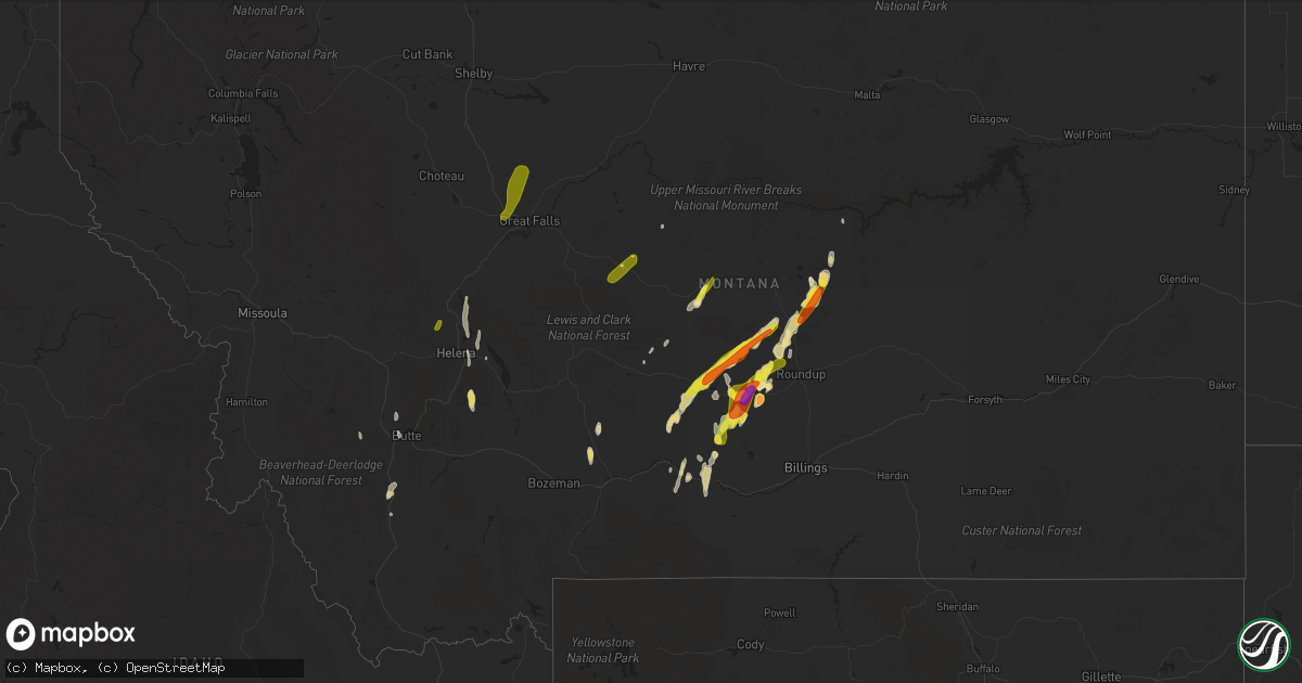
Hail Map in Montana on May 19, 2020
Get this storm
May 19 map
$229
one time, instant access
Download today. No call, no setup
Keep the $229
Bought the map and want the full workflow? Apply the entire $229 to a subscription within 7 days. None of it is wasted.
Every map, not just this one
This buys you this map. Subscription and you get every map we run, in the markets you choose from a few cities to whole states to nationwide. Plus real-time alerts the moment a storm fires.
Contact data
Name, contact info, occupancy, even credit band for addresses in the footprint. You go from where it hit to who to call.
Become the source they trust
Unlimited branding weather history reports on demand. You already have the documented answer ready for the property owner, and you are the one who showed up with it.
Property data and RoofTrace estimates
Pull up any address you have got, its value and the exact code rules for that jurisdiction, straight from One Click Code. Then RoofTrace estimates the squares, pitch, and roof value, priced the way you price.
Storm reports in Montana
Montana
| Date | Description |
|---|---|
| 05/19/20205:25 PM CDT | Penny to quarter sized hail reported. |
| 05/19/20204:25 AM CDT | At 924 PM MDT, a severe thunderstorm was located 15 miles south of Grass Range, or 23 miles southwest of Winnett, moving northeast at 30 mph. HAZARD...Golf ball size hail. SOURCE...Trained weather spotters. IMPACT...People and animals outdoors will be injured. Expect damage to roofs, siding, windows, and vehicles. This severe thunderstorm will remain over mainly rural areas of southeastern Fergus County. |
| 05/19/20203:59 AM CDT | At 858 PM MDT, a severe thunderstorm was located 23 miles south of Grass Range, or 25 miles northwest of Roundup, moving northeast at 30 mph. HAZARD...Half dollar size hail. SOURCE...Radar indicated. IMPACT...Damage to vehicles is expected. This severe thunderstorm will remain over mainly rural areas of southeastern Fergus County. |
| 05/19/20203:55 AM CDT | At 854 PM MDT, a severe thunderstorm was located 26 miles south of Grass Range, or 26 miles northwest of Roundup, moving northeast at 30 mph. HAZARD...Half dollar size hail. SOURCE...Radar indicated. IMPACT...Damage to vehicles is expected. This severe thunderstorm will remain over mainly rural areas of northwestern Musselshell County. This does not include the city of Roundup. |
| 05/19/20203:47 AM CDT | At 847 PM MDT, a severe thunderstorm was located near Lewistown, moving northeast at 30 mph. HAZARD...60 mph wind gusts and quarter size hail. SOURCE...Trained weather spotters. IMPACT...Hail damage to vehicles is expected. Expect wind damage to roofs, siding, and trees. Locations impacted include... Lewistown and Hilger. |
| 05/19/20203:40 AM CDT | A local report indicates 1.75 inch wind near WINNETT |
| 05/19/20203:19 AM CDT | At 818 PM MDT, a severe thunderstorm was located near Lewistown, moving north at 30 mph. HAZARD...60 mph wind gusts and quarter size hail. SOURCE...Radar indicated. IMPACT...Hail damage to vehicles is expected. Expect wind damage to roofs, siding, and trees. Locations impacted include... Lewistown, Moore and Glengarry. |
| 05/19/20203:01 AM CDT | At 800 PM MDT, a severe thunderstorm was located near Deadmans Basin Reservoir, or 20 miles east of Harlowton, moving northeast at 30 mph. HAZARD...Ping pong ball size hail. SOURCE...Radar indicated. IMPACT...People and animals outdoors will be injured. Expect damage to roofs, siding, windows, and vehicles. Locations impacted include... Franklin. |
| 05/19/20203:01 AM CDT | . |
| 05/19/20202:52 AM CDT | 1 inch hail reported near sun prairie. Mping report. |
| 05/19/20202:24 AM CDT | At 723 PM MDT, a severe thunderstorm was located 11 miles southwest of Deadmans Basin Reservoir, or 14 miles southeast of Harlowton, moving northeast at 25 mph. HAZARD...Half dollar size hail. SOURCE...Radar indicated. IMPACT...Damage to vehicles is expected. Locations impacted include... Harlowton, Deadmans Basin Reservoir and Shawmut. |
| 05/19/20202:19 AM CDT | A local report indicates 2.50 inch wind near N LAVINA |
| 05/19/20202:11 AM CDT | A local report indicates 1.00 inch wind near RYEGATE |
| 05/19/20202:08 AM CDT | A local report indicates 1.75 inch wind near 2 SE RYEGATE |
| 05/19/20201:47 AM CDT | A local report indicates 1.25 inch wind near RAPELJE |
| 05/19/202012:15 AM CDT | At 515 PM MDT, a severe thunderstorm was located 13 miles southwest of Stanford, moving northeast at 25 mph. HAZARD...60 mph wind gusts and quarter size hail. SOURCE...Radar indicated. IMPACT...Hail damage to vehicles is expected. Expect wind damage to roofs, siding, and trees. Locations impacted include... Stanford and Geyser. |
| 05/18/202011:39 PM CDT | At 438 PM MDT, a severe thunderstorm was located 24 miles south of Geyser, or 25 miles southwest of Stanford, moving northeast at 25 mph. HAZARD...60 mph wind gusts and quarter size hail. SOURCE...Radar indicated. IMPACT...Hail damage to vehicles is expected. Expect wind damage to roofs, siding, and trees. Locations impacted include... Neihart. |
| 05/18/20209:45 PM CDT | A local report indicates 1.75 inch wind near 23 NNW LAVINA |
| 05/18/20209:35 PM CDT | Spotter reports hail up to quarter size covering the roads. |
| 05/18/20209:30 PM CDT | Hail up to half dollar size. Hail a few inches deep in areas. |
| 05/18/20209:25 PM CDT | Hail lasted for 20 minutes. |
Cities Impacted by Hail Map on May 19, 2020
- Roundup, MT
- Grass Range, MT
- Melville, MT
- Lavina, MT
- Big Timber, MT
- Shawmut, MT
- Ryegate, MT
- Abernathy, TX
- Winnett, MT
- Lubbock, TX
- Shallowater, TX
- Anton, TX
- Plainview, TX
- Hale Center, TX
- Simla, CO
- Agate, CO
- Rocky Ford, CO
- Grenville, NM
- Hereford, TX
- Childress, TX
- Silverton, TX
- Manzanola, CO
- Wilsall, MT
- Livingston, MT
- Quitaque, TX
- Lockney, TX
- Douglas, WY
- Arlington, CO
- Sugar City, CO
- Olney Springs, CO
- Ordway, CO
- Crowley, CO
- Ralls, TX
- McLeod, MT
- Greycliff, MT
- Melrose, MT
- Silver Star, MT
- Divide, MT
- Dillon, MT
- Twin Bridges, MT
- Boulder, MT
- Floydada, TX
- Lorenzo, TX
- Crosbyton, TX
- Wheatland, WY
- Absarokee, MT
- Reed Point, MT
- East Helena, MT
- Slaton, TX
- Wilson, TX
- Tahoka, TX
- Post, TX
- Turkey, TX
- Hart, TX
- Dimmitt, TX
- Kress, TX
- Chugwater, WY
- Moore, MT
- Tulia, TX
- Helena, MT
- Wolf Creek, MT
- Geyser, MT
- Olton, TX
- Rapelje, MT
- Butte, MT
- Coffee Creek, MT
- Garrett, WY
- Clancy, MT
- Glendo, WY
- Two Dot, MT
- Karval, CO
- Broadview, MT
- Power, MT
- Carter, MT
- Floweree, MT
- Claude, TX
- Lewistown, MT
- Littlefield, TX
- Wolfforth, TX
- Cheyenne, WY
- Glen, MT
- Stanford, MT
- Boone, CO
- Earth, TX
- Mathis, TX
- Wayside, TX
- Belle Glade, FL
- Tell, TX
- Great Falls, MT
- Sun River, MT
- Buford, WY
- Wellington, CO
- Buffalo, MT
- Gillette, WY
- Loxahatchee, FL
- Wise River, MT
- Idalou, TX
- West Palm Beach, FL
- Vona, CO
- San Jon, NM
- Bard, NM
- Marysville, MT
- Canyon Creek, MT
- Vaughn, MT
- Dutton, MT


