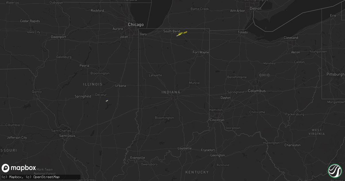
Hail Map in Indiana on May 19, 2019
Get this storm
May 19 map
$229
one time, instant access
Download today. No call, no setup
Keep the $229
Bought the map and want the full workflow? Apply the entire $229 to a subscription within 7 days. None of it is wasted.
Every map, not just this one
This buys you this map. Subscription and you get every map we run, in the markets you choose from a few cities to whole states to nationwide. Plus real-time alerts the moment a storm fires.
Contact data
Name, contact info, occupancy, even credit band for addresses in the footprint. You go from where it hit to who to call.
Become the source they trust
Unlimited branding weather history reports on demand. You already have the documented answer ready for the property owner, and you are the one who showed up with it.
Property data and RoofTrace estimates
Pull up any address you have got, its value and the exact code rules for that jurisdiction, straight from One Click Code. Then RoofTrace estimates the squares, pitch, and roof value, priced the way you price.
Storm reports in Indiana
Indiana
| Date | Description |
|---|---|
| 05/19/20196:30 PM CDT | Pole barn roof damage. |
| 05/19/20196:19 PM CDT | Numerous large tree limbs down... Power outage. |
| 05/19/20196:19 PM CDT | Reports of several 6 to 10 inch tree limbs snapped on the east side of fortville. Time estimated from radar. |
| 05/19/20196:08 PM CDT | Trees and tree tops were reported blown down at county road 300 north and 900 east on the blackford/jay county line. |
| 05/19/20195:40 PM CDT | Large tree branch snapped. |
| 05/19/20195:25 PM CDT | Tree down across road. |
| 05/19/20195:19 PM CDT | 1 inch diameter tree limbs broken off. Shingles blown off roofs. Mping report. |
| 05/19/20195:15 PM CDT | Trees down. |
| 05/19/20195:10 PM CDT | Over 600 customers without power. |
| 05/19/20195:10 PM CDT | Power lines down across road. |
| 05/19/20195:10 PM CDT | Tree feel down onto power pole. Power knocked out. |
| 05/19/20195:08 PM CDT | Multiple large branches snapped. Power lines on road. Trampoline blown across street. |
| 05/19/20195:08 PM CDT | A local report indicates 60 MPH wind near 2 SSW WINDFALL |
| 05/19/20195:07 PM CDT | Reported via social media. |
| 05/19/20195:06 PM CDT | 16 inch partially dead tree blown down. Measured 48 mph gust. |
| 05/19/20195:04 PM CDT | Power lines down... Blocking road. |
| 05/19/20195:03 PM CDT | Healthy 6 to 8 inch diameter tree limbs down. |
| 05/19/20194:52 PM CDT | 12 inch diameter tree down across market st. |
| 05/19/20194:47 PM CDT | Dispatch center relayed power poles downed near county road 600n west of forest. Time estimated from radar. |
| 05/19/20194:40 PM CDT | Large 12 inch diameter live tree limb down. |
| 05/19/20194:40 PM CDT | Dispatch center relayed multiple large healthy tree limbs across county road 500s. Time estimated from radar. |
| 05/19/20194:35 PM CDT | Tree knocked down. |
| 05/19/20194:17 PM CDT | Tree damage along us 35. Estimated 50 mph wind gusts. |
| 05/19/20194:14 PM CDT | Relayed via broadcast media. |
| 05/19/20194:08 PM CDT | Power outages reported. |
| 05/19/20194:02 PM CDT | 50 to 60 mph estimated winds. |
| 05/19/20194:00 PM CDT | Trees uprooted or snapped. Roof blown off. |
| 05/19/20193:52 PM CDT | Reports of power outages. |
| 05/19/20193:40 PM CDT | Gazebo destroyed. Time estimated from radar. |
| 05/19/20193:25 PM CDT | Reports of about 1000 users without power across fountain co. |
| 05/19/20193:15 PM CDT | Corrects previous tstm wnd dmg report from attica. Over 300 power outages reported. |
| 05/19/20192:43 AM CDT | At 743 PM EDT, severe thunderstorms were located along a line extending from near Alexandria to 9 miles southeast of Anderson, moving northeast at 55 mph. HAZARD...60 mph wind gusts. SOURCE...Radar indicated. IMPACT...Expect damage to roofs, siding, and trees. Locations impacted include... Muncie, Anderson, Alexandria, Yorktown, Chesterfield, Albany, Eaton, Daleville, Parker City, Selma, Sulphur Springs, Mooreland, Mount Summit, Losantville, Modoc, Springport, Blountsville, Summit Lake State Park, Ball State University and Prairie Creek Reservoir.This includes Interstate 69 between mile markers 228 and 245. |
| 05/19/20192:25 AM CDT | At 724 PM EDT, severe thunderstorms were located along a line extending from 7 miles north of Greenfield to near Shelbyville, moving east at 40 mph. This storm has shown consistent weak rotation in central Shelby county. HAZARD...60 mph wind gusts and penny size hail. SOURCE...Radar indicated. IMPACT...Expect damage to roofs, siding, and trees. Locations impacted include... Shelbyville, Greenfield, New Castle, Rushville, Fortville, Ingalls, Knightstown, Morristown, Carthage, Spiceland, Shirley, Markleville, Kennard, Wilkinson, Mooreland, Lewisville, Fairland, Milroy, Glenwood and Straughn.This includes the following highways... Interstate 70 between mile markers 98 and 133. Interstate 74 between mile markers 107 and 123. |
| 05/19/20191:54 AM CDT | At 654 PM EDT, severe thunderstorms were located along a line extending from near Noblesville to near Speedway, moving east at 55 mph. HAZARD...60 mph wind gusts. SOURCE...Radar indicated. IMPACT...Expect damage to roofs, siding, and trees. Locations impacted include... Indianapolis, Muncie, Anderson, Carmel, Fishers, Noblesville, Lawrence, Greenfield, New Castle, Speedway, Westfield, Yorktown, Cumberland, Cicero, McCordsville, Pendleton, Fortville, Chesterfield, Ingalls and Knightstown.This includes the following highways... Interstate 65 between mile markers 110 and 118. Interstate 69 between mile markers 200 and 241. Interstate 70 between mile markers 76 and 126. |
| 05/19/20191:52 AM CDT | At 652 PM EDT, severe thunderstorms were located along a line extending from 6 miles south of Speedway to 7 miles southeast of Martinsville, moving east at 45 mph. HAZARD...60 mph wind gusts. SOURCE...Radar indicated. IMPACT...Expect damage to roofs, siding, and trees. Locations impacted include... Indianapolis, Shelbyville, Greenwood, Franklin, Greenfield, Beech Grove, Southport, New Whiteland, Edinburgh, Whiteland, Bargersville, New Palestine, Flat Rock, Princes Lakes, Geneva, Morristown, Trafalgar, St. Paul, Morgantown and Carthage.This includes the following highways... Interstate 65 between mile markers 79 and 110. Interstate 70 between mile markers 75 and 76. Interstate 74 between mile markers 93 and 123. |
| 05/19/20191:48 AM CDT | At 648 PM EDT, a severe thunderstorm was located over Hartford City, moving east at 40 mph. HAZARD...60 mph wind gusts and quarter size hail. SOURCE...Radar indicated. IMPACT...Hail damage to vehicles is expected. Expect wind damage to roofs, siding, and trees. Locations impacted include... Hartford City, Upland, Pennville, Center, Shamrock Lakes, Fiat, Balbec, Trenton and Mill Grove. |
| 05/19/20191:36 AM CDT | At 635 PM EDT, a severe thunderstorm was located near Brownsburg, or 13 miles northwest of Indianapolis, moving east at 45 mph. This storm has produced weak rotation north of Brownsburg. HAZARD...60 mph wind gusts. SOURCE...Radar indicated. IMPACT...Expect damage to roofs, siding, and trees. Locations impacted include... Indianapolis, Carmel, Fishers, Noblesville, Greenwood, Lawrence, Plainfield, Brownsburg, Greenfield, Beech Grove, Zionsville, Speedway, Mooresville, Danville, Southport, Westfield, Avon, Cumberland, McCordsville and Fortville.This includes the following highways... Interstate 65 between mile markers 99 and 132. Interstate 69 between mile markers 200 and 213. Interstate 70 between mile markers 58 and 101. Interstate 74 between mile markers 59 and 106. |
| 05/19/20191:07 AM CDT | At 607 PM EDT, severe thunderstorms were located along a line extending from near Kokomo to near Windfall City to Tipton, moving east at 50 mph. HAZARD...60 mph wind gusts and penny size hail. SOURCE...Radar indicated. IMPACT...Expect damage to roofs, siding, and trees. Locations impacted include... Marion, Hartford City, Gas City, Upland, Fairmount, Montpelier, Jonesboro, Sweetser, Swayzee, La Fontaine, Van Buren, Matthews, Sims, Converse, Warren, Lancaster, Fowlerton, Shamrock Lakes, Mount Etna and Mcnatts.This includes Interstate 69 in Indiana between mile markers 252 and279. |
| 05/19/201912:59 AM CDT | At 558 PM EDT, severe thunderstorms were located along a line extending from 11 miles southeast of Crawfordsville to 6 miles southwest of Greencastle, moving east at 35 mph. HAZARD...60 mph wind gusts and quarter size hail. SOURCE...Radar indicated. IMPACT...Hail damage to vehicles is expected. Expect wind damage to roofs, siding, and trees. Locations impacted include... Plainfield, Brownsburg, Greencastle, Danville, Avon, Pittsboro, Whitestown, Ladoga, Jamestown, Roachdale, Bainbridge, Fillmore, Coatesville, North Salem, Lizton, Amo, Carpentersville and Groveland.This includes the following highways... Interstate 65 between mile markers 128 and 134. Interstate 74 between mile markers 51 and 69. |
| 05/19/201912:59 AM CDT | At 557 PM EDT, severe thunderstorms were located along a line extending from South Whitley to 8 miles northwest of Huntington to near La Fontaine, moving northeast at 60 mph. The strongest winds will likely pass from Lagro to Huntington as well as from Washington Center to Fort Wayne. HAZARD...60 mph wind gusts and penny size hail. SOURCE...Radar indicated. IMPACT...Expect damage to roofs, siding, and trees. Locations impacted include... Fort Wayne, Huntington, New Haven, Auburn, Columbia City, Garrett, Butler, Tri-lakes, Huntertown, Waterloo, Churubusco, South Whitley, Andrews, Grabill, La Fontaine, St. Joe, Aboite, Leo-cedarville, Swan and Roanoke.This includes the following highways... Interstate 469 between mile markers 0 and 10, and between milemarkers 23 and 30. Interstate 69 in Indiana between mile markers 288 and 331. |
| 05/19/201912:53 AM CDT | At 552 PM EDT, severe thunderstorms were located along a line extending from 11 miles northeast of Frankfort to 9 miles northwest of Tipton, moving east at 45 mph. This storm has weak rotation in southwest Howard county. HAZARD...60 mph wind gusts and quarter size hail. SOURCE...Radar indicated. IMPACT...Hail damage to vehicles is expected. Expect wind damage to roofs, siding, and trees. Locations impacted include... Kokomo, Elwood, Alexandria, Tipton, Windfall, Greentown, Russiaville, Summitville, Atlanta, Sharpsville, Orestes, Kempton and Indian Heights. |
| 05/19/201912:36 AM CDT | At 535 PM EDT, severe thunderstorms were located along a line extending from near Akron to 7 miles east of Mexico to 6 miles northwest of Kokomo, moving northeast at 55 mph. Sporadic reports of tree damage as well as wind gusts as high as 57 mph have been recorded in Logansport, Denver and Walton. HAZARD...60 mph wind gusts and penny size hail. SOURCE...Radar indicated. IMPACT...Expect damage to roofs, siding, and trees. Locations impacted include... Peru, Wabash, North Manchester, Grissom Afb, South Whitley, Andrews, Bunker Hill, La Fontaine, Wells, Miami, Erie, Denver, Roann, Lagro, Amboy, Sidney, Richvalley, Bennetts Switch, Liberty Mills and Collamer. |
| 05/19/201912:27 AM CDT | At 527 PM EDT, severe thunderstorms were located along a line extending from 6 miles southeast of Clinton to 11 miles north of Sullivan, moving east at 40 mph. HAZARD...60 mph wind gusts and quarter size hail. SOURCE...Radar indicated. IMPACT...Hail damage to vehicles is expected. Expect wind damage to roofs, siding, and trees. Locations impacted include... Terre Haute, Greencastle, Brazil, Spencer, Cloverdale, Seelyville, Knightsville, Clay City, Rosedale, Harmony, Staunton, Fillmore, Carbon, Center Point, Riley, Quincy, Bridgeton, Reelsville, Saline City and Pimento.This includes Interstate 70 between mile markers 6 and 46. |
| 05/19/201912:22 AM CDT | At 521 PM EDT, severe thunderstorms were located along a line extending from 8 miles west of Walton to 6 miles west of Frankfort, moving east at 40 mph. A spotter estimated 60 MPH winds in Flora at 5:14 PM. HAZARD...60 mph wind gusts and quarter size hail. SOURCE...Public. IMPACT...Hail damage to vehicles is expected. Expect wind damage to roofs, siding, and trees. Locations impacted include... Kokomo, Frankfort, Greentown, Russiaville, Sharpsville, Burlington, Michigantown and Indian Heights. |
| 05/19/201912:14 AM CDT | At 514 PM EDT, a severe thunderstorm was located over Niles, moving northeast at 40 mph. HAZARD...60 mph wind gusts. SOURCE...Radar indicated. IMPACT...Expect damage to roofs, siding, and trees. Locations impacted include... Niles, Dowagiac, Cassopolis, Edwardsburg, Marcellus, Bertrand, Pokagon, Penn, Vandalia, Dailey, La Grange, Barron Lake, Sumnerville, Diamond Lake, Wakelee and Donnell Lake. |
| 05/19/201912:11 AM CDT | At 511 PM EDT, severe thunderstorms were located along a line extending from 15 miles southwest of Frankfort to 10 miles south of Crawfordsville, moving east at 45 mph. HAZARD...60 mph wind gusts and quarter size hail. SOURCE...Public. IMPACT...Hail damage to vehicles is expected. Expect wind damage to roofs, siding, and trees. Locations impacted include... Frankfort, Crawfordsville, Lebanon, Whitestown, Sheridan, Thorntown, Ladoga, Jamestown, Darlington, Kirklin, Linden, Colfax, New Market, Clarks Hill, Sharpsville, Advance, Michigantown, Waveland, New Ross and Kempton.This includes the following highways... Interstate 65 between mile markers 130 and 159. Interstate 74 between mile markers 31 and 54. |
| 05/18/201911:53 PM CDT | At 453 PM EDT, severe thunderstorms were located along a line extending from 9 miles northeast of Delphi to 7 miles southeast of Lafayette, moving east at 55 mph. HAZARD...60 mph wind gusts and penny size hail. SOURCE...Radar indicated. IMPACT...Expect damage to roofs, siding, and trees. Locations impacted include... Logansport, Peru, Grissom Afb, Walton, Bunker Hill, Mexico, Lincoln, Wells, Galveston, Miami, Erie, Denver, Onward, Clymers, Bennetts Switch, Wawpecong, Hoover, Peoria, Nead and Anoka. |
| 05/18/201911:44 PM CDT | At 444 PM EDT, severe thunderstorms were located along a line extending from near Veedersburg to 6 miles south of Newport, moving east at 55 mph. HAZARD...60 mph wind gusts and quarter size hail. SOURCE...Radar indicated. IMPACT...Hail damage to vehicles is expected. Expect wind damage to roofs, siding, and trees. Locations impacted include... Crawfordsville, Rockville, Thorntown, Montezuma, Ladoga, Waynetown, Roachdale, Darlington, Colfax, New Market, Hillsboro, Kingman, Waveland, Russellville, New Ross, Bloomingdale, Marshall, Wallace, Alamo and Carpentersville.This includes the following highways... Interstate 65 between mile markers 150 and 153. Interstate 74 between mile markers 17 and 48. |
| 05/18/201911:42 PM CDT | At 442 PM EDT/342 PM CDT/, a severe thunderstorm was located near La Porte, moving northeast at 40 mph. HAZARD...60 mph wind gusts and quarter size hail. SOURCE...Radar indicated. IMPACT...Hail damage to vehicles is expected. Expect wind damage to roofs, siding, and trees. Locations impacted include... South Bend, La Porte, Niles, Buchanan, New Carlisle, Berrien Springs, Three Oaks, Bertrand, Dayton, Baroda, Galien, Byron, Hudson Lake, Glendora, New Troy, Chain-o-lakes, Rolling Prarie, Hesston and Lydick.This includes Interstate 80 in Indiana between mile markers 49 and74. |
| 05/18/201911:32 PM CDT | At 431 PM EDT/331 PM CDT/, a severe thunderstorm was located over Three Oaks, or 11 miles west of Buchanan, moving northeast at 30 mph. HAZARD...60 mph wind gusts and quarter size hail. SOURCE...Radar indicated. IMPACT...Hail damage to vehicles is expected. Expect wind damage to roofs, siding, and trees. Locations impacted include... Niles, Buchanan, Three Oaks, Shorewood-Tower Hills-Harbert, Dayton, Baroda, Galien, Hesston, Glendora, New Troy and Sawyer.This includes the following highways... Interstate 80 in Indiana between mile markers 56 and 61. Interstate 94 in Michigan between mile markers 8 and 11. |
| 05/18/201911:27 PM CDT | At 426 PM EDT, severe thunderstorms were located along a line extending from 6 miles northeast of Otterbein to near Veedersburg, moving east at 35 mph. HAZARD...60 mph wind gusts and penny size hail. SOURCE...Radar indicated. IMPACT...Expect damage to roofs, siding, and trees. Locations impacted include... Lafayette, Frankfort, West Lafayette, Delphi, Flora, Rossville, Shadeland, Dayton, Battle Ground, Mulberry, Linden, Colfax, Camden, Clarks Hill, New Richmond, Wingate, Newtown, Mellott, Yeoman and Purdue University.This includes Interstate 65 between mile markers 152 and 183. |
| 05/18/201911:13 PM CDT | At 412 PM EDT, a severe thunderstorm was located near Templeton, moving east at 45 mph. HAZARD...60 mph wind gusts and penny size hail. SOURCE...Radar indicated. IMPACT...Expect damage to roofs, siding, and trees. Locations impacted include... Monticello, Brookston, Chalmers, Burnettsville, Badger Grove, Golden Hill, Idaville and Cedar Point.This includes Interstate 65 between mile markers 185 and 191. |
| 05/18/201911:07 PM CDT | At 406 PM EDT, severe thunderstorms were located along a line extending from near Danville to near Redmon, moving east at 40 mph. HAZARD...60 mph wind gusts. SOURCE...Radar indicated. IMPACT...Expect damage to roofs, siding, and trees. Locations impacted include... Veedersburg, Newport, Cayuga, Montezuma, Waynetown, Linden, Dana, Hillsboro, Kingman, Perrysville, Bloomingdale, Marshall, Wingate, Mellott, Wallace, Alamo, Lodi, Turkey Run State Park, Yeddo and Gessie.This includes Interstate 74 between mile markers 5 and 32. |
| 05/18/201910:55 PM CDT | At 355 PM EDT, severe thunderstorms were located along a line extending from near Talbot to Tilton, moving east at 35 mph. A 63 MPH wind gust was reported east of Rossville at 350 PM. HAZARD...60 mph wind gusts. SOURCE...Public. IMPACT...Expect damage to roofs, siding, and trees. Locations impacted include... West Lafayette, Covington, Veedersburg, Williamsport, Attica, Shadeland, West Lebanon, Perrysville, Newtown, Pine Village, State Line City, Pence, Foster, Tab, Gessie and Rainsville.This includes the following highways... Interstate 65 between mile markers 181 and 183. Interstate 74 between mile markers 1 and 16. |
| 05/18/20198:05 PM CDT | A large limb was pulled off a tree. |
| 05/18/20197:39 PM CDT | Multiple trees down near whitewater road and 227 intersection. Time estimated from radar. |
| 05/18/20197:10 PM CDT | Tree uprooted on bear creek road. Also... Multiple branches down in western wayne county. Time estimated from radar. |
All States Impacted by Hail Map on May 19, 2019
Cities Impacted by Hail Map on May 19, 2019
- Mercersburg, PA
- Mosquero, NM
- Logan, NM
- San Jon, NM
- Caroga Lake, NY
- Corinth, NY
- Northville, NY
- Greenfield Center, NY
- Hadley, NY
- Lake Luzerne, NY
- Queensbury, NY
- Fort Edward, NY
- South Glens Falls, NY
- Gloversville, NY
- Gansevoort, NY
- Wellsboro, PA
- Spearman, TX
- Granville Summit, PA
- Towanda, PA
- Monroeton, PA
- Canton, PA
- Troy, PA
- Jersey Shore, PA
- Lititz, PA
- Manheim, PA
- Lake Charles, LA
- Westlake, LA
- El Dorado, AR
- Stinnett, TX
- Minersville, PA
- Tremont, PA
- Tower City, PA
- Pottsville, PA
- Muir, PA
- Branchdale, PA
- Hegins, PA
- Pine Grove, PA
- Camden, NY
- Shippensburg, PA
- Deridder, LA
- Halifax, PA
- Conchas Dam, NM
- Trinity, TX
- Altoona, PA
- Marietta, PA
- Elizabethtown, PA
- Mount Joy, PA
- Newton, TX
- Wiergate, TX
- Tucumcari, NM
- Eagle Pass, TX
- Lewisberry, PA
- Dover, PA
- Wellsville, PA
- Mcalister, NM
- Elverson, PA
- Pottstown, PA
- Annville, PA
- Taberg, NY
- Rome, NY
- Ava, NY
- Blossvale, NY
- Lee Center, NY
- Wolcott, NY
- York, PA
- East Stroudsburg, PA
- Tamiment, PA
- Bushkill, PA
- Buchanan, VA
- Quemado, TX
- Mifflin, PA
- Mifflintown, PA
- McClure, PA
- Eagle Rock, VA
- Lexington, VA
- Camillus, NY
- Warners, NY
- Syracuse, NY
- Liverpool, NY
- Stratford, CA
- Reading, PA
- Huron, CA
- Adrian, TX
- Huntingdon, PA
- Stafford Springs, CT
- Mont Alto, PA
- Greencastle, PA
- Waynesboro, PA
- State Line, PA
- Clear Spring, MD
- Williamsport, MD
- Big Pool, MD
- Hagerstown, MD
- Fayetteville, PA
- Liberty, PA
- Berwick, PA
- Shickshinny, PA
- Danville, PA
- Chambersburg, PA
- Saint Thomas, PA
- Belvidere, NJ
- Bangor, PA
- Rohwer, AR
- Falls, PA
- Lowville, NY
- Copenhagen, NY
- Crossett, AR
- Hermitage, AR
- Beavertown, PA
- Reedsville, PA
- Milroy, PA
- Beaver Springs, PA
- Holland Patent, NY
- Clinton, LA
- State College, PA
- Pennsylvania Furnace, PA
- Petersburg, PA
- Merryville, LA
- Lovington, IL
- Bethany, IL
- Perryton, TX
- Bethel, PA
- Quincy, PA
- Maugansville, MD
- Orrtanna, PA
- Martinsburg, WV
- Falling Waters, WV
- Hedgesville, WV
- Hartley, TX
- Dumas, TX
- Dalhart, TX
- Stratford, TX
- Leesville, LA
- Manchester, PA
- York Haven, PA
- Wapwallopen, PA
- Hunlock Creek, PA
- Durhamville, NY
- Canastota, NY
- Verona Beach, NY
- Allentown, PA
- Whitehall, PA
- Saint Martinville, LA
- Miami, TX
- Morse, TX
- Booker, TX
- East Waterford, PA
- Blain, PA
- Doylesburg, PA
- Bard, NM
- Bethlehem, PA
- Hellertown, PA
- Hallsville, TX
- Evans, LA
- Kennard, TX
- Greensburg, LA
- Lebanon, PA
- Jim Thorpe, PA
- Lehighton, PA
- Warfordsburg, PA
- Strong, AR
- Spearsville, LA
- Marion, LA
- Terre Hill, PA
- Denver, PA
- Narvon, PA
- New Holland, PA
- Ephrata, PA
- Akron, PA
- East Earl, PA
- Leola, PA
- Stevens, PA
- Birdsboro, PA
- Smithsburg, MD
- Myersville, MD
- Provencal, LA
- Warriors Mark, PA
- Tyrone, PA
- Emerson, AR
- Castorland, NY
- Cogan Station, PA
- Linden, PA
- Trout Run, PA
- Elbridge, NY
- Memphis, NY
- Remsen, NY
- Hershey, PA
- Palmyra, PA
- Newton, NJ
- Frenchtown, NJ
- Milford, NJ
- Erwinna, PA
- Upper Black Eddy, PA
- Myerstown, PA
- Fredericksburg, PA
- Alligator, MS
- Crumrod, AR
- Westernville, NY
- Jasper, TX
- Zavalla, TX
- Shoemakersville, PA
- Girardville, PA
- Ashland, PA
- Newmanstown, PA
- Mount Gretna, PA
- Middletown, PA
- Reinholds, PA
- Robesonia, PA
- Wernersville, PA
- Schaefferstown, PA
- Grady, NM
- Melrose, NM
- Burkeville, TX
- Verona, NY
- Cold Brook, NY
- Hollidaysburg, PA
- Dillsburg, PA
- Mechanicsburg, PA
- Grantham, PA
- Huntington, TX
- Milton, PA
- Great Cacapon, WV
- Bainbridge, PA
- Williamstown, PA
- Mar Lin, PA
- Morgantown, PA
- York Springs, PA
- Richland, PA
- Mount Wolf, PA
- Rehrersburg, PA
- Oley, PA
- Womelsdorf, PA
- Mohnton, PA
- Schuylkill Haven, PA
- Mohrsville, PA
- Ringtown, PA
- Hummelstown, PA
- Fleetwood, PA
- East Berlin, PA
- Hamburg, PA
- Temple, PA
- Bernville, PA
- Etters, PA
- Seltzer, PA
- East Petersburg, PA
- Aspers, PA
- Gardners, PA
- Adamstown, PA
- Boyertown, PA
- Thomasville, PA
- New Cumberland, PA
- Leesport, PA
- Jonestown, PA
- Emigsville, PA
- Bechtelsville, PA
- Stony Creek, NY
- North Ferrisburgh, VT
- Bristol, VT
- Hinesburg, VT
- Charlotte, VT
- Phoenix, NY
- Clay, NY
- Baldwinsville, NY
- Chittenango, NY
- Kirkville, NY
- Middleburg, PA
- Colmesneil, TX
- Croghan, NY
- Quakertown, PA
- Kintnersville, PA
- Richlandtown, PA
- Kaplan, LA
- Diboll, TX
- Spring, TX
- Magnolia, TX
- Port Matilda, PA
- Vega, TX
- Jordan, NY
- Warrensburg, NY
- Belleville, PA
- Berkeley Springs, WV
- Poland, NY
- Big Cove Tannery, PA
- Needmore, PA
- Hancock, MD
- Sunray, TX
- Iowa, LA
- Sulphur, LA
- Boonsboro, MD
- Huntsville, TX
- Kutztown, PA
- Macungie, PA
- Mertztown, PA
- Lyon Station, PA
- Topton, PA
- Breinigsville, PA
- Blandon, PA
- Alburtis, PA
- Lufkin, TX
- Balko, OK
- Floyd, NM
- Taiban, NM
- Wells, NY
- Port Royal, PA
- McAlisterville, PA
- Richfield, PA
- Pine Grove Mills, PA
- Spring Mills, PA
- Boalsburg, PA
- Schnecksville, PA
- Coplay, PA
- Bon Wier, TX
- Tamaqua, PA
- Wakarusa, IN
- Elkhart, IN
- Goshen, IN
- Dauphin, PA
- McGehee, AR
- Gruver, TX
- Pulaski, NY
- Sandy Creek, NY
- Summerdale, PA
- Marysville, PA
- Enola, PA
- Harrisburg, PA
- Biglerville, PA
- Woodstock, NY
- Saugerties, NY
- Nazareth, PA
- Bath, PA
- Sugarloaf, PA
- Bloomsburg, PA
- Nescopeck, PA
- Rock Glen, PA
- Nanticoke, PA
- Zion Grove, PA
- Glen Lyon, PA
- Shavertown, PA
- Dallas, PA
- Carlisle, PA
- Boiceville, NY
- Blossburg, PA
- Earth, TX
- East Syracuse, NY
- Minoa, NY
- Auburn, PA
- Morris Run, PA
- Dry Run, PA
- Concord, PA
- Spring Run, PA
- Paw Paw, WV
- Apple Springs, TX
- Northampton, PA
- Wind Gap, PA
- Danielsville, PA
- Boonville, NY
- Cleveland, NY
- Stittville, NY
- Kunkletown, PA
- Effort, PA
- Kempton, PA
- Lenhartsville, PA
- Orwigsburg, PA
- Beaver, OK
- Coopersburg, PA
- Riegelsville, PA
- Perkasie, PA
- East Greenville, PA
- Palm, PA
- Pennsburg, PA
- Ottsville, PA
- New Iberia, LA
- Selinsgrove, PA
- Ponchatoula, LA
- Jeanerette, LA
- New Tripoli, PA
- Plain Dealing, LA
- Patterson, LA
- Abbeville, LA
- Blairstown, NJ
- Columbia, NJ
- Stroudsburg, PA
- Mount Bethel, PA
- Breaux Bridge, LA
- Livingston Manor, NY
- Parksville, NY
- Benton, LA
- Neelyton, PA
- McConnellsburg, PA
- Fort Loudon, PA
- Fannettsburg, PA
- Athol, NY
- Windham, NY
- Prattsville, NY
- Jewett, NY
- Ashland, NY
- Hensonville, NY
- East Jewett, NY
- Hunter, NY
- Middlebury, IN
- Alba, PA
- Mineral Point, PA
- Johnstown, PA
- Brownstown, PA
- Brodheadsville, PA
- Saylorsburg, PA


