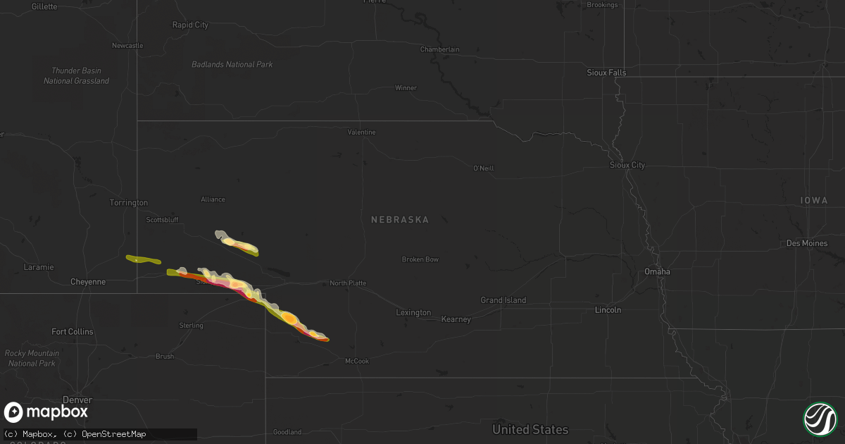
Hail Map in Nebraska on May 19, 2014
Get this storm
May 19 map
$229
one time, instant access
Download today. No call, no setup
Keep the $229
Bought the map and want the full workflow? Apply the entire $229 to a subscription within 7 days. None of it is wasted.
Every map, not just this one
This buys you this map. Subscription and you get every map we run, in the markets you choose from a few cities to whole states to nationwide. Plus real-time alerts the moment a storm fires.
Contact data
Name, contact info, occupancy, even credit band for addresses in the footprint. You go from where it hit to who to call.
Become the source they trust
Unlimited branding weather history reports on demand. You already have the documented answer ready for the property owner, and you are the one who showed up with it.
Property data and RoofTrace estimates
Pull up any address you have got, its value and the exact code rules for that jurisdiction, straight from One Click Code. Then RoofTrace estimates the squares, pitch, and roof value, priced the way you price.
Storm reports in Nebraska
Nebraska
| Date | Description |
|---|---|
| 05/18/201411:29 PM CDT | A local report indicates 1.75 inch wind near 7 NNW HAMLET |
| 05/18/201410:39 PM CDT | A local report indicates 2.75 inch wind near 13 N IMPERIAL |
| 05/18/201410:38 PM CDT | A local report indicates 2.00 inch wind near 12 SSE GRANT |
| 05/18/201410:25 PM CDT | A local report indicates 1.00 inch wind near 10 ENE VENANGO |
| 05/18/20149:35 PM CDT | A local report indicates 70 MPH wind near 4 SE CHAPPELL |
| 05/18/20149:35 PM CDT | A local report indicates 1.75 inch wind near 1 S CHAPPELL |
| 05/18/20149:35 PM CDT | A local report indicates 1.75 inch wind near CHAPPELL |
| 05/18/20149:20 PM CDT | A local report indicates 1.25 inch wind near 1 S CHAPPELL |
| 05/18/20149:12 PM CDT | Measured 2-3/8 inch... 2 miles east of lodgepole on hwy 30 |
| 05/18/20149:04 PM CDT | Window broken... Neighbor also had window shattered |
| 05/18/20148:55 PM CDT | A local report indicates 2.00 inch wind near 4 E SIDNEY |
| 05/18/20148:47 PM CDT | A local report indicates 1.00 inch wind near 10 N OSHKOSH |
| 05/18/20148:24 PM CDT | A local report indicates 1.75 inch wind near 8 N LISCO |
| 05/18/20148:14 PM CDT | Trooper reported hail on hwy 30 north of i-80 |
| 05/18/20148:00 PM CDT | A local report indicates 1.00 inch wind near DIX |
| 05/18/20147:36 PM CDT | Ranged from nickle to quarter |
| 05/18/20147:18 PM CDT | Nickel to quarter size hail. |
All States Impacted by Hail Map on May 19, 2014
Cities Impacted by Hail Map on May 19, 2014
- Wauneta, NE
- Julesburg, CO
- Big Springs, NE
- Imperial, NE
- Grant, NE
- Sidney, NE
- Gurley, NE
- Chappell, NE
- Lisco, NE
- Oshkosh, NE
- Broadwater, NE
- Dix, NE
- Potter, NE
- Herman, MN
- Hoffman, MN
- Ovid, CO
- Lodgepole, NE
- Venango, NE
- Palisade, NE
- Hayes Center, NE
- Enders, NE
- Madrid, NE
- Hanover, VA
- Mechanicsville, VA
- Pine Bluffs, WY
- Lewellen, NE
- Prairie Du Chien, WI
- Woodman, WI
- Mount Hope, WI
- Danvers, MN
- Milbank, SD
- Twin Brooks, SD
- Odessa, MN
- Correll, MN
- Holloway, MN
- Corona, SD
- Ortonville, MN
- Big Stone City, SD
- Benson, MN
- Appleton, MN
- Kensington, MN
- Kimball, NE
- Albin, WY
- Bushnell, NE
- Harrisburg, NE
- Kimball, MN
- South Haven, MN
- Clearwater, MN


