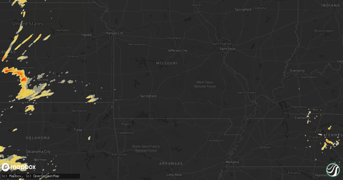
Hail Map on May 19, 2012
Get this storm
May 19 map
$229
one time, instant access
Download today. No call, no setup
Keep the $229
Bought the map and want the full workflow? Apply the entire $229 to a subscription within 7 days. None of it is wasted.
Every map, not just this one
This buys you this map. Subscription and you get every map we run, in the markets you choose from a few cities to whole states to nationwide. Plus real-time alerts the moment a storm fires.
Contact data
Name, contact info, occupancy, even credit band for addresses in the footprint. You go from where it hit to who to call.
Become the source they trust
Unlimited branding weather history reports on demand. You already have the documented answer ready for the property owner, and you are the one who showed up with it.
Property data and RoofTrace estimates
Pull up any address you have got, its value and the exact code rules for that jurisdiction, straight from One Click Code. Then RoofTrace estimates the squares, pitch, and roof value, priced the way you price.
States Impacted by Hail Map on May 19, 2012
Storm reports
Colorado
| Date | Description |
|---|---|
| 05/19/20126:47 PM CDT | A local report indicates 1.00 inch wind near 5 NNE ROSITA |
| 05/19/20123:17 PM CDT | Fell for 9 minutes. |
| 05/19/201211:02 AM CDT | Significant accumulation on the ground. |
Tennessee
| Date | Description |
|---|---|
| 05/19/20126:54 PM CDT | Tree blown down in east brentwood |
| 05/19/20126:40 PM CDT | A local report indicates 1.00 inch wind near NE NOLENSVILLE |
| 05/19/20126:09 PM CDT | Hailed for 10 minutes |
| 05/19/20126:00 PM CDT | In the city of lebanon. |
| 05/19/20125:47 PM CDT | Up to half dollar size hail covering the ground in unionville |
| 05/19/20125:30 PM CDT | Public reported via facebook a few trees blown down at old fort parkway and chaffin place in murfreesboro. Time estimated. |
| 05/19/20125:23 PM CDT | Spotter reported up to golf ball size hail in blackman. Corrected lat/lon location. |
| 05/19/20125:23 PM CDT | Blackmon area up to golf ball size |
| 05/19/20125:01 PM CDT | Numerous reports of nickel to quarter size hail along old fort pkwy |
| 05/19/20124:40 PM CDT | Reported near beechgrove via facebook. Time estimated. |
| 05/19/20124:25 PM CDT | Public reported home weather station near beechgrove measured a wind gust of 64 mph. |
| 05/19/20124:23 PM CDT | A local report indicates 1.00 inch wind near SPRINGFIELD |
| 05/19/20123:10 PM CDT | A local report indicates 1.00 inch wind near 2 NW OLD CUMBERLAND |
| 05/19/20122:30 PM CDT | A local report indicates 1.00 inch wind near 5 SW PIKEVILLE |
Florida
| Date | Description |
|---|---|
| 05/19/20122:55 PM CDT | Skywarn spotter in palm city observed nickel to quarter size hail. |
| 05/19/20122:50 PM CDT | Skywarn spotter in southwest stuart measured one inch hail and wind gust to 34 mph. |
| 05/19/20122:50 PM CDT | Skywarn spotter in palm city reported quarter size hail from 350 pm to 4 pm. |
| 05/19/20122:20 PM CDT | Lasted for about 15 minutes |
| 05/18/20128:20 PM CDT | Possible tornado at rand motel located on 34th street north. Portion of roof torn off and tossed onto cars adjacent to motel. Time estimated by radar. |
Minnesota
| Date | Description |
|---|---|
| 05/19/20126:30 PM CDT | Near st. Thomas univ. 10 cottonwood tree limb down |
| 05/19/20126:27 PM CDT | A local report indicates 1.00 inch wind near RICHFIELD |
| 05/19/20126:00 PM CDT | Large tree uprooted |
| 05/18/20128:15 PM CDT | Two 12 inch diameter trees down near intersection of se elm street and se kasota ave. Approximate time. |
| 05/18/20128:07 PM CDT | A local report indicates 1.00 inch wind near APPLE VALLEY |
| 05/18/20128:07 PM CDT | A local report indicates 1.00 inch wind near 1 N BURNSVILLE |
| 05/18/20128:00 PM CDT | A local report indicates 1.00 inch wind near APPLE VALLEY |
| 05/18/20128:00 PM CDT | A local report indicates 1.00 inch wind near 2 W EAGAN |
| 05/18/20127:35 PM CDT | Western st. Paul |
| 05/18/20127:34 PM CDT | A local report indicates 1.00 inch wind near 5 SW ST PAUL |
| 05/18/20127:23 PM CDT | A local report indicates 1.00 inch wind near BLOOMINGTON |
| 05/18/20127:23 PM CDT | A local report indicates 1.00 inch wind near 3 NE BURNSVILLE |
| 05/18/20127:15 PM CDT | A local report indicates 1.00 inch wind near 2 W SHAKOPEE |
Kansas
| Date | Description |
|---|---|
| 05/19/20126:58 PM CDT | Tornado damage path is 300 yards wide. Some homes were damaged. Powerlines were down. |
| 05/19/20126:52 PM CDT | A local report indicates 1.50 inch wind near 13 WNW ANTHONY |
| 05/19/20126:52 PM CDT | A local report indicates 1.50 inch wind near 13 WSW ANTHONY |
| 05/19/20126:49 PM CDT | A local report indicates 1.25 inch wind near 13 WSW ANTHONY |
| 05/19/20126:49 PM CDT | Correction. Location is wnw not wsw. |
| 05/19/20126:46 PM CDT | A local report indicates a tornado near 5 SE SPIVEY |
| 05/19/20126:45 PM CDT | Farmstead was hit by tornado. Extent of damage is unknown at this time. |
| 05/19/20126:45 PM CDT | Moderate damage to a mobile home |
| 05/19/20126:45 PM CDT | Two homes damaged with one having roof ripped off. Heavy tree damage with uprooted trees. |
| 05/19/20126:41 PM CDT | A local report indicates a tornado near 3 SSW RAGO |
| 05/19/20126:40 PM CDT | Spotter reported oil tanks and wells damaged in the area with multiple tree damage near the kingman and harper county line |
| 05/19/20126:40 PM CDT | Spotter reported oil tanks and wells damaged in the area with multiple tree damage near the kingman and harper county line |
| 05/19/20126:38 PM CDT | A local report indicates a tornado near 3 ENE ATTICA |
| 05/19/20126:35 PM CDT | A local report indicates 1.25 inch wind near 3 WNW CULVER |
| 05/19/20126:33 PM CDT | A local report indicates a tornado near 6 W HARPER |
| 05/19/20126:33 PM CDT | A local report indicates a tornado near 3 NW HARPER |
| 05/19/20126:32 PM CDT | Rope tornado. |
| 05/19/20126:28 PM CDT | A local report indicates a tornado near 4 SSE SPIVEY |
| 05/19/20126:27 PM CDT | Pea to golfball size hail for 3 to 4 minutes. |
| 05/19/20126:23 PM CDT | A local report indicates 1.00 inch wind near 2 N STERLING |
| 05/19/20126:20 PM CDT | A local report indicates 1.75 inch wind near 4 N GLENDALE |
| 05/19/20126:19 PM CDT | Tornado is a bit bigger than a rope. |
| 05/19/20126:15 PM CDT | Rope tornado. |
| 05/19/20126:06 PM CDT | A local report indicates 3.00 inch wind near 5 ENE KINGMAN |
| 05/19/20126:04 PM CDT | Estimating 65 to 70 mph winds. |
| 05/19/20126:03 PM CDT | A local report indicates 3.00 inch wind near 4 ENE KINGMAN |
| 05/19/20126:01 PM CDT | A local report indicates a tornado near 5 SW KINGMAN |
| 05/19/20125:58 PM CDT | Rope tornado. |
| 05/19/20125:58 PM CDT | Rope tornado. |
| 05/19/20125:57 PM CDT | A local report indicates 1.75 inch wind near KINGMAN |
| 05/19/20125:53 PM CDT | Spotter reported landspout tornado |
| 05/19/20125:49 PM CDT | Spotter reported rope tornado |
| 05/19/20125:45 PM CDT | Rope tornado. |
| 05/19/20125:44 PM CDT | A local report indicates 1.75 inch wind near 7 SW KINGMAN |
| 05/19/20125:38 PM CDT | A local report indicates a tornado near 5 NW KINGMAN |
| 05/19/20125:35 PM CDT | A local report indicates 1.00 inch wind near 9 S HUTCHINSON |
| 05/19/20125:30 PM CDT | Hail up to the size of ping pong balls reported. |
| 05/19/20125:30 PM CDT | A local report indicates 2.00 inch wind near 1 WSW ARLINGTON |
| 05/19/20125:24 PM CDT | A local report indicates 2.00 inch wind near 2 SW ARLINGTON |
| 05/19/20125:21 PM CDT | A local report indicates 1.75 inch wind near ARLINGTON |
| 05/19/20125:18 PM CDT | A local report indicates 1.75 inch wind near 4 SW ARLINGTON |
| 05/19/20125:18 PM CDT | A local report indicates 1.50 inch wind near ELLSWORTH |
| 05/19/20125:17 PM CDT | A local report indicates 2.00 inch wind near 1 WSW ARLINGTON |
| 05/19/20125:15 PM CDT | A local report indicates 1.00 inch wind near ARLINGTON |
| 05/19/20125:15 PM CDT | A local report indicates 1.00 inch wind near ELLSWORTH |
| 05/19/20125:11 PM CDT | A local report indicates 1.75 inch wind near 5 W ARLINGTON |
| 05/19/20125:11 PM CDT | A local report indicates 2.00 inch wind near 4 W ARLINGTON |
| 05/19/20125:06 PM CDT | A local report indicates 1.25 inch wind near 4 S SYLVIA |
| 05/19/20125:00 PM CDT | Public reported ping pong ball size hail covering his yard. |
| 05/19/20124:45 PM CDT | A local report indicates 60 MPH wind near 3 E SYLVAN GROVE |
| 05/19/20124:45 PM CDT | A local report indicates 1.50 inch wind near 3 E SYLVAN GROVE |
| 05/19/20124:44 PM CDT | A local report indicates 1.75 inch wind near SYLVIA |
| 05/19/20124:31 PM CDT | A local report indicates 1.75 inch wind near 5 E STAFFORD |
| 05/19/20124:27 PM CDT | This time was estimated by radar data. |
| 05/19/20124:23 PM CDT | A local report indicates 1.75 inch wind near ZENITH |
| 05/19/20124:22 PM CDT | A local report indicates 1.00 inch wind near N ZENITH |
| 05/19/20124:22 PM CDT | A local report indicates 1.00 inch wind near 4 E STAFFORD |
| 05/19/20124:15 PM CDT | Half dollar sized hail...just hail no wind or rain |
| 05/19/20124:07 PM CDT | A local report indicates 1.50 inch wind near 3 N STAFFORD |
| 05/19/20124:05 PM CDT | A local report indicates 1.00 inch wind near 5 E ST. JOHN |
| 05/19/20123:59 PM CDT | A local report indicates 1.00 inch wind near 7 SSE ST. JOHN |
| 05/19/20123:50 PM CDT | A local report indicates 2.50 inch wind near 4 SE ST. JOHN |
| 05/19/20123:45 PM CDT | A local report indicates 2.00 inch wind near GREAT BEND |
| 05/19/20123:42 PM CDT | A local report indicates 1.00 inch wind near GREAT BEND |
| 05/19/20123:38 PM CDT | A local report indicates 1.00 inch wind near GREAT BEND |
| 05/19/20123:36 PM CDT | A local report indicates 1.00 inch wind near 2 NNE DILLWYN |
| 05/19/20123:35 PM CDT | A local report indicates 2.00 inch wind near 2 W GREAT BEND |
| 05/19/20121:46 PM CDT | Chaser reports large quantity of hail covering highway 25 at russell springs |
| 05/18/20129:57 PM CDT | A local report indicates 1.00 inch wind near SEVERY |
| 05/18/20129:48 PM CDT | Nickel to quarter size hail. |
| 05/18/20129:47 PM CDT | Spotters reported 70 to 80 mph winds near eureka city lake with numerous trees down. |
| 05/18/20128:30 PM CDT | A local report indicates 66 MPH wind near MCCONNELL AIR FORCE BAS |
| 05/18/20128:26 PM CDT | A local report indicates 1.25 inch wind near MULVANE |
| 05/18/20128:00 PM CDT | A local report indicates 1.00 inch wind near ESE ABILENE |
| 05/18/20127:35 PM CDT | A local report indicates 1.75 inch wind near 1 SE NILES |
| 05/18/20127:32 PM CDT | A local report indicates 1.50 inch wind near 5 WNW ARGONIA |
| 05/18/20127:02 PM CDT | Spotter reported tornado on the northwest side of harper. |
Iowa
| Date | Description |
|---|---|
| 05/18/20129:55 PM CDT | Trees down in marcus. Wind gusts estimated at 60 mph. |
| 05/18/20129:30 PM CDT | Trees down in wasta. Wind gusts estimated at 60 mph. |
| 05/18/20129:21 PM CDT | 2 reports of trees down on houses in town. |
| 05/18/20129:20 PM CDT | Barn blown into the road |
| 05/18/20129:14 PM CDT | Spotter estimated wind gusts near 60 mph for about 5 minutes. |
| 05/18/20129:10 PM CDT | Several large trees knocked down in a cemetary. Winds estimated at 60 mph. |
| 05/18/20129:06 PM CDT | Wind speed estimated. Tree damage...extent unknown. |
| 05/18/20128:51 PM CDT | A local report indicates 60 MPH wind near 3 NE DENISON AIRPORT |
| 05/18/20128:50 PM CDT | Power out in town. |
| 05/18/20128:50 PM CDT | Power out and branches down in town. Trampoline wrapped around a tree. Time estimated from radar. |
| 05/18/20128:40 PM CDT | A local report indicates 70 MPH wind near 6 WSW DOW CITY |
| 05/18/20128:38 PM CDT | A local report indicates 65 MPH wind near 7 WSW DOW CITY |
| 05/18/20128:36 PM CDT | Several trees and an old barn blown over at the intersection of 140th street and q avenue. Time estimated from radar. |
| 05/18/20128:21 PM CDT | Estimated wind gust to 45mph with small tree limbs down. |
| 05/18/20128:20 PM CDT | Gusts estimated 70mph. Gas station signs blown down. |
| 05/18/20128:15 PM CDT | Tree limbs and one power pole down in modale. Delayed report. Time estimated. |
| 05/18/20128:00 PM CDT | Mostly small hail...but a few stones to size of quarters |
| 05/18/20127:25 PM CDT | A local report indicates 1.00 inch wind near 1 N ONAWA |
| 05/18/20127:05 PM CDT | A local report indicates 1.00 inch wind near ONAWA |
North Carolina
| Date | Description |
|---|---|
| 05/19/20124:42 PM CDT | Hail ranging in size up to a quarter fell at the asheville regional airport. There were two periods of hail in the storm and hail partially covered the ground during a |
Nebraska
| Date | Description |
|---|---|
| 05/19/20126:55 PM CDT | A local report indicates 1.00 inch wind near 3 SE BRAINARD |
| 05/19/20126:50 PM CDT | A local report indicates 1.00 inch wind near 2 SW GRAND ISLAND |
| 05/19/20126:47 PM CDT | Hail reported near highways 2 and 34. |
| 05/19/20126:44 PM CDT | A local report indicates 1.00 inch wind near GRAND ISLAND |
| 05/19/20126:35 PM CDT | A local report indicates 1.75 inch wind near 1 E SCHUYLER |
| 05/19/20126:28 PM CDT | A local report indicates 1.00 inch wind near 6 N MALCOLM |
| 05/19/20126:28 PM CDT | Quarter and golfball hail. |
| 05/19/20126:22 PM CDT | A local report indicates 1.00 inch wind near 1 S SCHUYLER |
| 05/19/20126:22 PM CDT | Just south of i-80 |
| 05/19/20126:20 PM CDT | A local report indicates 1.00 inch wind near 2 NE MALCOLM |
| 05/19/20126:20 PM CDT | A grain bin was reported in the southbound lanes of highway 81 near strang between roads s and t. Time estimated from radar. |
| 05/19/20126:15 PM CDT | Wind gust reported at the airport 36006g57kt |
| 05/19/20126:11 PM CDT | A local report indicates 1.00 inch wind near 6 ESE BENNINGTON |
| 05/19/20126:03 PM CDT | Quarter size hail at intersection of cr 309 and cr w |
| 05/19/20126:02 PM CDT | Power lines down south of ruskin. |
| 05/19/20126:01 PM CDT | Spotters reporting a tornado 1 mile west of shickley. |
| 05/19/20125:57 PM CDT | 8-10 power poles down from hardy to sw of ruskin. Pivots knocked over also. |
| 05/19/20125:50 PM CDT | A local report indicates 1.50 inch wind near SUPERIOR |
| 05/19/20125:48 PM CDT | Pivot overturned near highway 8 on the east side of hardy. Tree limbs 2 inches in diameter snapped in hardy. Time estimated from radar. |
| 05/19/20125:44 PM CDT | A local report indicates 1.00 inch wind near SUPERIOR |
| 05/19/20125:40 PM CDT | Delayed report from severe storms on the 19th. Hail up to quarter size. Time estimated from radar data. Report from nerain observer. |
| 05/19/20125:30 PM CDT | Hail sized from pea to slightly larger than a quarter. Covered most of the ground |
| 05/19/20125:24 PM CDT | At least 3 fields located approximately 1 mile west of the deweese spur off of highway 14 and 1 mile north of the county line were damaged. Time estimated from radar. |
| 05/19/20125:16 PM CDT | Quarter to golf ball hail almost covering ground |
| 05/19/20125:12 PM CDT | Dime to quarter size hail reported. |
| 05/19/20125:12 PM CDT | Wind gust measured at intersection of highways 14 and 4 in northern nuckolls county. |
| 05/19/20125:05 PM CDT | Hail up to the size of hen eggs reported. Trees damaged. |
| 05/19/20124:30 PM CDT | Delayed report from severe storms on the 19th. Golf ball size hail for nearly 20 minutes starting around 430 pm. Time estimated from radar. Severe damage to crops and b |
| 05/19/20124:20 PM CDT | A local report indicates 1.50 inch wind near BLUE HILL |
| 05/19/20124:18 PM CDT | A local report indicates 1.00 inch wind near 3 W BLUE HILL |
| 05/19/20124:15 PM CDT | Nickel to quarter size hail started around 405 pm. |
| 05/19/20124:14 PM CDT | A local report indicates 1.00 inch wind near 3 W MERNA |
| 05/19/20123:08 PM CDT | Most of the hail was pea to nickel with a few up to the size of ping pong balls. |
| 05/19/20122:36 PM CDT | Mostly pea to nickel size hail but a few stones were as large as a quarter. |
| 05/19/20122:13 PM CDT | Ground is covered white with hail. |
| 05/19/20122:07 PM CDT | A local report indicates 1.00 inch wind near 13 E HAYES CENTER |
| 05/19/20121:58 PM CDT | Ground covered white with hail. |
| 05/19/20121:28 PM CDT | Hail was ping pong ball in size. |
| 05/19/20121:15 PM CDT | A local report indicates 1.75 inch wind near 13 NW STRATTON NE |
| 05/19/20121:10 PM CDT | A local report indicates 1.75 inch wind near STRATTON NE |
| 05/19/20121:05 PM CDT | A local report indicates 1.00 inch wind near 4 N MAX |
| 05/19/201212:47 PM CDT | A local report indicates 1.00 inch wind near BENKELMAN |
| 05/19/20129:40 AM CDT | Nickel to quarter size hail covering the ground. |
| 05/19/20129:26 AM CDT | Ground covered with hail. The largest size of hail was a quarter. |
| 05/18/20129:36 PM CDT | A local report indicates 1.00 inch wind near 2 S CEDAR CREEK |
| 05/18/20128:11 PM CDT | A local report indicates 1.00 inch wind near 6 ESE BENNINGTON |
| 05/18/20128:00 PM CDT | Measured by public with wind equipment. Horse barn destroyed and siding damage to house. |
| 05/18/20127:55 PM CDT | 6 inch diameter tree uprooted. Wind equipment measured 58 mph gust. |
| 05/18/20127:55 PM CDT | Barn roof blown off |
| 05/18/20127:53 PM CDT | A local report indicates 60 MPH wind near ASHLAND |
| 05/18/20127:45 PM CDT | 3-5 inch diameter tree branches broken. |
| 05/18/20127:41 PM CDT | A local report indicates 70 MPH wind near WAHOO |
| 05/18/20127:38 PM CDT | Nickle size hail. |
| 05/18/20127:00 PM CDT | A local report indicates 1.00 inch wind near NORTH BEND |
Oklahoma
| Date | Description |
|---|---|
| 05/19/20126:48 PM CDT | A local report indicates 1.00 inch wind near 7 NNE LEEDEY |
| 05/19/20126:19 PM CDT | A local report indicates 1.75 inch wind near 6 N ANGORA |
| 05/19/20125:50 PM CDT | A local report indicates 1.00 inch wind near 9 N ANGORA |
| 05/19/20125:28 PM CDT | A local report indicates 1.00 inch wind near SHARON |
| 05/19/20123:20 AM CDT | A local report indicates 1.00 inch wind near 1 N ELMORE CITY |
| 05/19/20121:40 AM CDT | A local report indicates 67 MPH wind near 2 SW PINK |
| 05/19/20121:20 AM CDT | A local report indicates 1.25 inch wind near 4 NNE ROCKY |
| 05/19/20121:10 AM CDT | Winds estimated near 60 mph along i-35 between sw 134th and 89th street. Small tree limbs down. |
| 05/19/20121:03 AM CDT | A local report indicates 70 MPH wind near WILL ROGERS AIRPORT |
| 05/19/201212:25 AM CDT | A local report indicates 63 MPH wind near 2 SSW MINCO |
| 05/19/201212:21 AM CDT | A local report indicates 1.00 inch wind near CORDELL |
| 05/19/201212:07 AM CDT | A local report indicates 59 MPH wind near ALTUS AIR FORCE BASE |
| 05/19/201212:05 AM CDT | A local report indicates 1.00 inch wind near ALTUS AIR FORCE BASE |
| 05/19/201212:05 AM CDT | A local report indicates 1.00 inch wind near 2 E ALTUS |
| 05/18/201211:59 PM CDT | A local report indicates 1.00 inch wind near ALTUS |
| 05/18/201211:45 PM CDT | A local report indicates 1.75 inch wind near 6 W ALTUS |
| 05/18/201210:50 PM CDT | A local report indicates 58 MPH wind near 4 SE HOBART |
| 05/18/201210:49 PM CDT | A local report indicates 1.75 inch wind near MANGUM |
| 05/18/201210:47 PM CDT | Numerous on the ground |
| 05/18/201210:45 PM CDT | A local report indicates 1.00 inch wind near MANGUM |
| 05/18/20129:29 PM CDT | A local report indicates 1.00 inch wind near 2 N WILLOW |
| 05/18/20129:10 PM CDT | Just east of the jct of hwy 34 and 152 |
| 05/18/20129:01 PM CDT | Large amounts on ground |
| 05/18/20128:50 PM CDT | A local report indicates 2.75 inch wind near 3 S ELK CITY |
| 05/18/20128:50 PM CDT | A local report indicates 1.75 inch wind near ELK CITY |
| 05/18/20128:36 PM CDT | A local report indicates 1.00 inch wind near 4 W STAFFORD |
| 05/18/20127:55 PM CDT | A local report indicates 1.75 inch wind near 4 NNE ELK CITY |
| 05/18/20127:48 PM CDT | A local report indicates 1.00 inch wind near 4 W MUTUAL |
| 05/18/20127:34 PM CDT | Quarter size hail fell for at least 2 minutes |
Cities Impacted by Hail Map on May 19, 2012
- Lyons, KS
- Altus, OK
- Elk City, OK
- Clearwater, NE
- Neligh, NE
- Kingman, KS
- Murdock, KS
- Omaha, NE
- Leedey, OK
- Arnett, OK
- Schuyler, NE
- Mooreland, OK
- Union, NE
- Nehawka, NE
- Bon Aqua, TN
- Chisago City, MN
- Lindstrom, MN
- Scandia, MN
- Forest Lake, MN
- Erick, OK
- Hinckley, MN
- Graettinger, IA
- Woodward, OK
- Loretto, MN
- Maple Plain, MN
- Buffalo, MN
- Rockford, MN
- Delano, MN
- Hamel, MN
- Minneapolis, MN
- Andover, MN
- Circle Pines, MN
- Callaway, NE
- Argonia, KS
- Freeport, KS
- Attica, KS
- Anthony, KS
- Danville, KS
- Harper, KS
- Rogers, NE
- Sutton, NE
- Glenvil, NE
- Edgar, NE
- Fairfield, NE
- Geneva, NE
- Deweese, NE
- Clay Center, NE
- Shickley, NE
- Lawrence, NE
- Blue Hill, NE
- Winfield, KS
- Fort Cobb, OK
- Valley, NE
- Mankato, KS
- Sharon, OK
- Mutual, OK
- Great Bend, KS
- Udall, KS
- Oxford, KS
- Binger, OK
- Tobias, NE
- Dorchester, NE
- Alexandria, NE
- Western, NE
- Milligan, NE
- Friend, NE
- Ohiowa, NE
- Daykin, NE
- Murfreesboro, TN
- Benkelman, NE
- Max, NE
- Wauneta, NE
- Stratton, NE
- Palisade, NE
- Chickasha, OK
- Ninnekah, OK
- Cedar Bluffs, NE
- Lyons, NE
- Oakland, NE
- Oneill, NE
- Superior, NE
- Nelson, NE
- Cheyenne, OK
- Mayfield, KS
- Caldwell, KS
- Wellington, KS
- Belle Plaine, KS
- Delavan, MN
- Whiting, IA
- Hornick, IA
- Rodney, IA
- Onawa, IA
- Castana, IA
- Smithland, IA
- Liberty, TN
- Lindsborg, KS
- Salina, KS
- Falun, KS
- Brookville, KS
- Randall, KS
- Jewell, KS
- Mason City, NE
- Solomon, KS
- New Cambria, KS
- Elk River, MN
- Sewanee, TN
- Christiana, TN
- Readyville, TN
- Saint Paul, MN
- Idalia, CO
- Bell Buckle, TN
- Jasper, GA
- Potwin, KS
- Benton, KS
- Whitewater, KS
- Colony, OK
- Valparaiso, NE
- Raymond, NE
- St John, KS
- Stafford, KS
- Elmore City, OK
- Springfield, NE
- Papillion, NE
- Bellevue, NE
- La Vista, NE
- Council Bluffs, IA
- Plattsmouth, NE
- Louisville, NE
- Giltner, NE
- Mangum, OK
- Isanti, MN
- Lebanon, TN
- Springfield, TN
- Tekamah, NE
- Decatur, NE
- Henderson, NE
- Hampton, NE
- Sylvan Grove, KS
- Tryon, NE
- Liberty, KS
- Mound Valley, KS
- Cherryvale, KS
- Coffeyville, KS
- Long Lake, MN
- Moville, IA
- Anthon, IA
- Oto, IA
- Branson, CO
- Hobart, OK
- Howard, KS
- Severy, KS
- Wilson, KS
- Burlington, CO
- Wayzata, MN
- Somerset, WI
- New Prague, MN
- Savage, MN
- Jordan, MN
- South Saint Paul, MN
- Burnsville, MN
- Hugo, MN
- Mendota, MN
- Webster, MN
- Prior Lake, MN
- Willernie, MN
- Osceola, WI
- Inver Grove Heights, MN
- Newport, MN
- Lakeville, MN
- Stillwater, MN
- Lake Elmo, MN
- Marine On Saint Croix, MN
- Elko New Market, MN
- Bruno, NE
- David City, NE
- Resaca, GA
- Chatsworth, GA
- York, NE
- Waco, NE
- Gresham, NE
- Utica, NE
- Bradshaw, NE
- Dodge, NE
- Linwood, NE
- Columbus, NE
- North Bend, NE
- Bellwood, NE
- Shelby, NE
- Adams, TN
- Saint Francis, KS
- Folsom, NM
- Pauls Valley, OK
- Wynnewood, OK
- Trenton, NE
- Rockvale, TN
- Shelbyville, TN
- Unionville, TN
- Chapel Hill, TN
- Alda, NE
- Morse Bluff, NE
- Brainard, NE
- Nash, OK
- Medford, OK
- Wakita, OK
- Farmington, MN
- El Dorado, KS
- Leon, KS
- Sandstone, MN
- Butler, OK
- Silver Lake, MN
- Gotebo, OK
- Olustee, OK
- Carnegie, OK
- Cordell, OK
- Foss, OK
- Headrick, OK
- Altus Afb, OK
- Hydro, OK
- Mountain View, OK
- Clinton, OK
- Carter, OK
- Vinson, OK
- Sweetwater, OK
- Sayre, OK
- Cement, OK
- Corn, OK
- Willow, OK
- Lookeba, OK
- Gracemont, OK
- Duke, OK
- Verden, OK
- Blair, OK
- Rocky, OK
- Granite, OK
- Arapaho, OK
- Sentinel, OK
- Anadarko, OK
- Weatherford, OK
- Canute, OK
- Dill City, OK
- Lone Wolf, OK
- Minco, OK
- Hammon, OK
- Cyril, OK
- Apache, OK
- Holyrood, KS
- Ellsworth, KS
- Lorraine, KS
- Peck, KS
- Derby, KS
- Mulvane, KS
- Braham, MN
- Spivey, KS
- Chapman, NE
- Moorefield, NE
- Brady, NE
- Maxwell, NE
- Logan, IA
- Ruskin, NE
- Hardy, NE
- Oak, NE
- Guide Rock, NE
- Pleasant View, TN
- Ashland City, TN
- Chapmansboro, TN
- Beverly, KS
- Tescott, KS
- Hayes Center, NE
- Maywood, NE
- Shafer, MN
- Everly, IA
- Spencer, IA
- Peterson, IA
- Royal, IA
- Estherville, IA
- Columbia, TN
- Mount Pleasant, TN
- Hopkins, MN
- Neola, IA
- Minden, IA
- Geneseo, KS
- Little River, KS
- Allensville, KY
- Woodbine, IA
- Arden, NC
- Fletcher, NC
- Mills River, NC
- Elsie, NE
- Weston, NE
- Custer City, OK
- Taloga, OK
- Hollis, OK
- Dodson, TX
- Wellington, TX
- Wagner, SD
- Red Cloud, NE
- Burr Oak, KS
- Clearwater, KS
- Darwin, MN
- Boys Town, NE
- Ellijay, GA
- Hershey, NE
- Alva, OK
- Gothenburg, NE
- Champlin, MN
- Arlington, KS
- Partridge, KS
- Abbyville, KS
- Sylvia, KS
- Pretty Prairie, KS
- Plevna, KS
- Turon, KS
- Paxton, NE
- Oakley, KS
- Monument, KS
- Winona, KS
- Bee, NE
- Ceresco, NE
- Prague, NE
- Wahoo, NE
- Garland, NE
- Dwight, NE
- Malmo, NE
- Malcolm, NE
- Weeping Water, NE
- Ames, NE
- Fremont, NE
- Hudson, WI
- New Richmond, WI
- Harvard, NE
- Vero Beach, FL
- Okeechobee, FL
- Woodbury, TN
- Loxahatchee, FL
- Scribner, NE
- Rising City, NE
- Osceola, NE
- Howells, NE
- Hooper, NE
- Clarkson, NE
- Stuart, NE
- Burwell, NE
- Atkinson, NE
- Amelia, NE
- Morganton, GA
- Sparta, TN
- Stromsburg, NE
- Augusta, KS
- Aurora, NE
- Lincoln, NE
- Walton, NE
- Immokalee, FL
- Wilber, NE
- Crete, NE
- Greeley, NE
- Litchfield, MN
- Hutchinson, MN
- Nickerson, NE
- Arlington, NE
- Blair, NE
- Bennington, NE
- Kennard, NE
- Washington, NE
- Craig, NE
- Herman, NE
- Randolph, NE
- Wood River, NE
- Palm City, FL
- Stuart, FL
- Indiantown, FL
- Schleswig, IA
- Russellville, KY
- Paoli, OK
- Wayne, OK
- Dorrance, KS
- Ayr, NE
- Brasstown, NC
- Benedict, NE
- Anoka, MN
- Bethel, MN
- Rogers, MN
- Dayton, MN
- Cedar, MN
- Saint Francis, MN
- Saint Michael, MN
- Howard Lake, MN
- Cokato, MN
- Glidden, IA
- Vail, IA
- Denison, IA
- Eads, CO
- Curtis, NE
- Wellfleet, NE
- McCook, NE
- Anselmo, NE
- Merna, NE
- Farnam, NE
- Norwich, KS
- Lawton, OK
- Brook Park, MN
- Pine City, MN
- Grasston, MN
- Gould, OK
- Welch, OK
- Beloit, KS
- Barnard, KS
- Culbertson, NE
- Petersburg, NE
- Antioch, TN
- Nolensville, TN
- Nashville, TN
- Brentwood, TN
- Edna, KS
- Grand Island, NE
- Doniphan, NE
- Phillips, NE
- Lakeland, MN
- Chapman, KS
- Abilene, KS
- Harlan, IA
- Stapleton, NE
- Seneca, NE
- Milaca, MN
- Albertville, AL
- Lexington, NE
- Eddyville, NE
- Briscoe, TX
- Wheeler, TX
- Redbird, OK
- Porter, OK
- Coweta, OK
- Sedgwick, KS
- Maize, KS
- Wichita, KS
- Goddard, KS
- Colwich, KS
- Valley Center, KS
- Seward, NE
- Macksville, KS
- Waldron, KS
- Milton, KS
- Hazelton, KS
- Cheney, KS
- Conway Springs, KS
- Milan, KS
- Correctionville, IA
- Taylor, NE
- Center City, MN
- Greenwood, NE
- Waverly, NE
- Eagle, NE
- Alvo, NE
- Mora, MN
- Clarksville, TN
- Guthrie, KY
- Olmstead, KY
- Danbury, IA
- Battle Creek, IA
- Mapleton, IA
- Morton, MN
- Franklin, MN
- Redwood Falls, MN
- Hector, MN
- Bird Island, MN
- Olivia, MN
- Rosemount, MN
- Gretna, NE
- Ashland, NE
- South Bend, NE
- Dow City, IA
- Charter Oak, IA
- Glencoe, MN
- Morrison, TN
- Mcminnville, TN
- Grenville, NM
- Ruthven, IA
- Crossville, TN
- West Point, NE
- Colon, NE
- Pleasant Dale, NE
- Doyle, TN
- Quebeck, TN
- Martell, NE
- Oswego, KS
- Bartlett, KS
- Sutherland, NE
- Milford, NE
- Winthrop, MN
- Winsted, MN
- Stewart, MN
- Brownton, MN
- Gibbon, MN
- Missouri Valley, IA
- Fairmont, NE
- Westside, IA
- Manning, IA
- Manilla, IA
- Cozad, NE
- Bradyville, TN
- Long Pine, NE
- Alpha, MN
- Staplehurst, NE
- Flagler, CO
- Rockwood, TN
- Avoca, NE
- Ardmore, OK
- Springer, OK
- Spencer, TN
- McCool Junction, NE
- Cedar Hill, TN
- Foreston, MN
- Roca, NE
- Altoona, KS
- Ong, NE
- Davenport, NE
- Grafton, NE
- Saint Paul, NE
- Kim, CO
- Pritchett, CO
- Willow River, MN
- Stacy, MN
- Firth, NE
- Adams, NE
- Latham, KS
- Piedmont, KS
- Beaumont, KS
- Cambridge, MN
- Grandy, MN
- Stanchfield, MN
- Haysville, KS
- Wolbach, NE
- Spalding, NE
- Ada, OK
- Stratford, OK
- Titonka, IA
- Bancroft, IA
- Burt, IA
- Claflin, KS
- Hoisington, KS
- Ord, NE
- Underwood, IA
- Isabella, OK
- Okeene, OK
- Model, CO
- Trinidad, CO
- Walsenburg, CO
- Blanchard, OK
- Swea City, IA
- Fort Calhoun, NE
- Manchester, TN
- Beechgrove, TN
- Persia, IA
- Manchester, OK
- Clewiston, FL
- Bessie, OK
- Mountain Park, OK
- Fletcher, OK
- Crawford, OK
- Rush Springs, OK
- Roosevelt, OK
- Snyder, OK
- Exeter, NE
- Beaver Crossing, NE
- Pocasset, OK
- Tecumseh, OK
- Trumbull, NE
- Elba, NE
- Amherst, NE
- Grand Junction, IA
- Rippey, IA
- De Witt, NE
- Comfrey, MN
- Fairfax, MN
- Thedford, NE
- Shakopee, MN
- Arcadia, IA
- Breda, IA
- Shelby, IA
- Blencoe, IA
- Deloit, IA
- Miller, NE
- Pond Creek, OK
- Crossville, AL
- Andale, KS
- Mount Hope, KS
- Hickman, NE
- Palisade, MN
- Esbon, KS
- Lebanon, KS
- Webber, KS
- Bladen, NE
- Dassel, MN
- Sumner, NE
- Ravenna, NE
- Rockville, NE
- North Branch, MN
- Harris, MN
- Winchester, TN
- Dunlap, TN
- Wallace, KS
- Sharon Springs, KS
- Bird City, KS
- Parks, NE
- Waterloo, NE
- Elkhorn, NE
- Ogden, IA
- Kingfisher, OK
- Lincoln, KS
- Kirkman, IA
- Geary, OK
- Lester Prairie, MN
- Mcgregor, MN
- Dolliver, IA
- Armstrong, IA
- Childress, TX
- Denton, NE
- Ogilvie, MN
- Labelle, FL
- Cleghorn, IA
- Mead, NE
- Washta, IA
- Pierson, IA
- Marcus, IA
- Snyder, NE
- Cushing, IA
- Cherokee, IA
- Kingsley, IA
- Little Sioux, IA
- Abie, NE
- Yutan, NE
- Uehling, NE
- Holstein, IA
- Quimby, IA
- Ogallala, NE
- Verdigre, NE
- Page, NE
- Lynch, NE
- Niobrara, NE
- Albion, NE
- Smyrna, TN
- Tecumseh, NE
- Ainsworth, NE
- Marlow, OK
- Duncan, OK
- Sargent, NE
- Strang, NE
- Cortland, NE
- Clatonia, NE
- Hallam, NE
- Minneapolis, KS
- Kanopolis, KS
- Mayer, MN
- Offutt Afb, NE
- Sturgeon Lake, MN
- Moose Lake, MN
- Tribune, KS
- Garden Plain, KS
- Moorhead, IA
- Lehigh Acres, FL
- Dunlap, IA
- Asbury, MO
- Eagleville, TN
- Calumet, OK
- Lindsay, OK
- Sterling, KS
- Westcliffe, CO
- Enders, NE
- Young Harris, GA
- Norfolk, NE
- Cook, MN
- McClelland, IA
- Star Prairie, WI
- Dresser, WI
- Hoxie, KS
- Grinnell, KS
- Aitkin, MN
- Princeton, MN
- Emmet, NE
- Chambers, NE
- Jackson, MN
- Spirit Lake, IA
- Lakefield, MN
- Kiowa, KS
- Scotia, NE
- Grantsburg, WI
- Chester, OK
- McCune, KS
- Dante, SD
- Butterfield, MN
- Young America, MN
- Cologne, MN
- Pickrell, NE
- Filley, NE
- Wyoming, MN
- Osseo, MN
- Blairsville, GA
- Suches, GA
- Wyandotte, OK
- Fairmount, GA
- Waleska, GA
- Pacific Junction, IA
- Glenwood, IA
- Hastings, NE
- Inland, NE
- Polk, NE
- Macomb, OK
- Asher, OK
- Elmwood, NE
- Murdock, NE
- Crescent, IA
- Cedar Creek, NE
- Avoca, IA
- Honey Creek, IA
- Carter Lake, IA
- Eden Prairie, MN
- Terril, IA
- Watertown, MN
- New Germany, MN
- Montrose, MN
- Inman, KS
- Hutchinson, KS
- Bluff City, KS
- Viola, KS
- Granada, MN
- Maple Grove, MN
- La Vergne, TN
- Smithville, TN
- Stratton, CO
- Chase, KS
- Windom, KS
- Shawnee, OK
- Blue Earth, MN
- Elmore, MN
- Mineral Bluff, GA
- Murphy, NC
- Orlinda, TN
- Cross Plains, TN
- Portland, TN
- Flandreau, SD
- Rock Island, TN
- Elgin, OK
- Vona, CO
- Bradley, OK
- Green, KS
- Broken Bow, NE
- Longdale, OK
- Ringsted, IA
- Wartrace, TN
- Konawa, OK
- Winnetoon, NE
- Oak Park, MN
- Foley, MN
- Elkton, KY
- Pleasanton, NE
- Petersburg, TN
- Pulaski, TN
- Frankewing, TN
- Sherburn, MN
- Fairbury, NE
- Fall River, KS
- Center, NE
- Franklin, KY
- Mound, MN
- Bassett, NE
- Santa Fe, TN
- Waynoka, OK
- Larrabee, IA
- Newcastle, OK
- Union City, OK
- Cherry Log, GA
- Blue Ridge, GA
- Kimball, MN
- Geuda Springs, KS
- Eureka, KS
- Johnstown, NE
- Haven, KS
- Dickens, IA
- Rose Hill, KS
- Douglass, KS
- Kenesaw, NE
- Sprague, NE
- Bennet, NE
- Swanton, NE
- Plymouth, NE
- Loup City, NE
- Litchfield, NE
- Sheridan Lake, CO
- Siren, WI
- Orr, MN
- Otoe, NE
- Dunbar, NE
- Pikeville, TN
- Deer Lodge, TN
- Ithaca, NE
- North Loup, NE
- Fredonia, KS
- Talking Rock, GA
- Ulysses, NE
- Surprise, NE
- Wanette, OK
- North Platte, NE
- Altamont, KS
- Arnolds Park, IA
- Milford, IA
- College Grove, TN
- Byars, OK
- Washington, KS
- Cunningham, KS
- Longton, KS
- Wann, OK
- S Coffeyville, OK
- Madisonville, KY
- Hanson, KY
- Burns, TN
- Waverly, MN
- Monticello, MN
- Albertville, MN
- Hanover, MN
- Waconia, MN