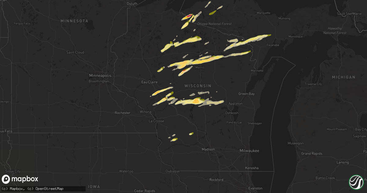
Hail Map in Wisconsin on May 18, 2024
Get this storm
May 18 map
$229
one time, instant access
Download today. No call, no setup
Keep the $229
Bought the map and want the full workflow? Apply the entire $229 to a subscription within 7 days. None of it is wasted.
Every map, not just this one
This buys you this map. Subscription and you get every map we run, in the markets you choose from a few cities to whole states to nationwide. Plus real-time alerts the moment a storm fires.
Contact data
Name, contact info, occupancy, even credit band for addresses in the footprint. You go from where it hit to who to call.
Become the source they trust
Unlimited branding weather history reports on demand. You already have the documented answer ready for the property owner, and you are the one who showed up with it.
Property data and RoofTrace estimates
Pull up any address you have got, its value and the exact code rules for that jurisdiction, straight from One Click Code. Then RoofTrace estimates the squares, pitch, and roof value, priced the way you price.
Storm reports in Wisconsin
Wisconsin
| Date | Description |
|---|---|
| 05/18/20246:38 PM CDT | Corrects previous hail report from 2 se port edwards. Report from mping: quarter |
| 05/18/20246:12 PM CDT | Tree branches down. |
| 05/18/20245:55 PM CDT | Wsaw-tv relayed report of 1 inch hail in irma. |
| 05/18/20245:48 PM CDT | A local report indicates 1.00 inch wind near 2 SE Goodrich |
| 05/18/20245:48 PM CDT | 2 facebook reports of hail around golf ball size near irma. One had a picture with the largest hailstone next to a ruler. Hail lasted up to 20 minutes. At one location. |
| 05/18/20245:35 PM CDT | A local report indicates 1.00 inch wind near Arbor Vitae |
| 05/18/20245:30 PM CDT | A local report indicates 1.00 inch wind near 2 N Dorchester |
| 05/18/20245:25 PM CDT | A local report indicates 1.25 inch wind near Woodruff |
| 05/18/20245:22 PM CDT | At lighthouse resort on fence lake. Wind gusts estimated at 50 mph. |
| 05/18/20245:19 PM CDT | Size was determined from a picture on waow facebook. |
| 05/18/20245:15 PM CDT | A local report indicates 1.00 inch wind near 4 SW Lac Du Flambeau |
| 05/18/20245:06 PM CDT | A local report indicates 1.25 inch wind near 1 SSE Rib Lake |
| 05/18/20244:54 PM CDT | Hailed for about 1 minute. |
| 05/18/20244:47 PM CDT | Public report of hail ranging from quarter to golf ball sized hail on pine lake in central iron county. |
| 05/18/20244:37 PM CDT | A local report indicates 1.00 inch wind near Rib Lake |
| 05/18/20244:19 PM CDT | Corrects previous hail report from chelsea. Size was determined from a picture on waow facebook. |
| 05/18/20244:10 PM CDT | Public estimated hail the size of a quarter on t |
| 05/18/20244:10 PM CDT | Public estimated hail the size of a quarter on the southwest side of lac sault dore. |
| 05/18/20244:06 PM CDT | A local report indicates 1.00 inch wind near 1 E Blair |
| 05/18/20244:03 PM CDT | Trained spotter reported hail between 1 inch and 1.5 inches in diameter coating the ground. |
| 05/18/20243:58 PM CDT | Quarter sized hail reported. |
| 05/18/20243:54 PM CDT | A local report indicates 1.50 inch wind near 7 WNW Humbird |
| 05/18/20243:34 PM CDT | Half dollar to golf ball size hail. |
| 05/18/20243:08 PM CDT | Time estimated based on radar. Spotter also reported gusty winds but no large branches were down. |
| 05/17/20249:15 PM CDT | Facebook report of 1 inch diameter hail near weyauwega. |
| 05/17/20248:03 PM CDT | A local report indicates 1.00 inch wind near 2 SW Beecher |
| 05/17/20247:38 PM CDT | Report from mping: quarter |
| 05/17/20247:19 PM CDT | A local report indicates 1.00 inch wind near Boaz |
| 05/17/20247:10 PM CDT | A local report indicates 1.25 inch wind near 4 SW Bosstown |
| 05/17/20247:04 PM CDT | Portage county emergency manager reported 1 inch hail in wisconsin rapids. |
| 05/17/20247:03 PM CDT | Trained spotter |
| 05/17/20247:03 PM CDT | Trained spotter reported quarter inch hail along with an estimated 70 mph wind gusts. Report of a tree sown over the road. |
| 05/17/20247:00 PM CDT | Trained spotter reported 1 inch hail. Location estimated. |
| 05/17/20247:00 PM CDT | 2 facebook reports of golf ball size hail on the south side of wisconsin rapids. Pictures available. Dents on vehicles reported. |
All States Impacted by Hail Map on May 18, 2024
Cities Impacted by Hail Map on May 18, 2024
- Pensacola, FL
- Magnolia Springs, AL
- Loxley, AL
- Elberta, AL
- Silverhill, AL
- Foley, AL
- Robertsdale, AL
- Gulf Shores, AL
- Daphne, AL
- Lillian, AL
- Fairhope, AL
- Bon Secour, AL
- Summerdale, AL
- Orange Beach, AL
- Baker, FL
- Crestview, FL
- Russellville, AL
- Mount Hope, AL
- Moulton, AL
- Aberdeen, MS
- Hamilton, MS
- Danville, AL
- Hartselle, AL
- Deland, FL
- Okahumpka, FL
- Lake Helen, FL
- Leesburg, FL
- Altoona, FL
- Umatilla, FL
- Houston, MS
- Okolona, MS
- Grand Island, FL
- Tavares, FL
- Madison, NC
- Reidsville, NC
- Groveoak, AL
- Langston, AL
- Guntersville, AL
- Vero Beach, FL
- Summerfield, NC
- Cornell, WI
- Cadott, WI
- Gardendale, AL
- Warrior, AL
- Fyffe, AL
- Section, AL
- Galax, VA
- Paisley, FL
- Strum, WI
- Whitehall, WI
- Morris, AL
- Kimberly, AL
- Pinson, AL
- Fort McCoy, FL
- Osseo, WI
- Independence, WI
- Fort Pierce, FL
- Pierson, FL
- Boyd, WI
- Holcombe, WI
- Gilman, WI
- Ladysmith, WI
- Winter, WI
- Medford, WI
- De Leon Springs, FL
- Remlap, AL
- Gordo, AL
- Trafford, AL
- Ormond Beach, FL
- Astor, FL
- Bunnell, FL
- Phillips, WI
- Saint Cloud, FL
- Fairchild, WI
- Buhl, AL
- Melbourne Beach, FL
- Springville, AL
- Augusta, WI
- Willard, WI
- Blair, WI
- Taylor, WI
- Black River Falls, WI
- Park Falls, WI
- Fosters, AL
- Tuscaloosa, AL
- Ralph, AL
- Hixton, WI
- Ettrick, WI
- Hayden, AL
- Kennan, WI
- Westboro, WI
- Merrillan, WI
- Alma Center, WI
- Lublin, WI
- Neillsville, WI
- Butternut, WI
- Rib Lake, WI
- Montreal, WI
- Fifield, WI
- Duncanville, AL
- Lincoln, AL
- Rogersville, TN
- Withee, WI
- Greenwood, WI
- Merrill, WI
- Mercer, WI
- Hurley, WI
- Bessemer, MI
- Eastaboga, AL
- Anniston, AL
- Wakefield, MI
- Ironwood, MI
- Ontonagon, MI
- Humbird, WI
- Greeneville, TN
- Lac Du Flambeau, WI
- Minocqua, WI
- Nisula, MI
- Mass City, MI
- Loxahatchee, FL
- Iron Belt, WI
- Ramsay, MI
- Tomahawk, WI
- Woodruff, WI
- Wellington, FL
- Bergland, MI
- Marenisco, MI
- Dorchester, WI
- Curtiss, WI
- Pompano Beach, FL
- Pittsville, WI
- Lake Worth, FL
- Gile, WI
- Stetsonville, WI
- Abbotsford, WI
- Athens, WI
- Irma, WI
- Ewen, MI
- Bruce Crossing, MI
- Warrens, WI
- Gleason, WI
- Coral Springs, FL
- Sylacauga, AL
- Babcock, WI
- Ranburne, AL
- Hobe Sound, FL
- Manitowish Waters, WI
- Boynton Beach, FL
- Goodwater, AL
- Palm Beach, FL
- Lake Worth Beach, FL
- Elcho, WI
- Wisconsin Rapids, WI
- Nekoosa, WI
- Necedah, WI
- Pelican Lake, WI
- Summit Lake, WI
- Deerbrook, WI
- Pearson, WI
- Port Edwards, WI
- Calumet, MI
- Hancock, MI
- Bancroft, WI
- Rhinelander, WI
- Crandon, WI
- Gays Mills, WI
- Soldiers Grove, WI
- Blue River, WI
- Pickerel, WI
- Lake Tomahawk, WI
- Viola, WI
- Richland Center, WI
- Muscoda, WI
- Plainfield, WI
- Almond, WI
- Laona, WI
- Wabeno, WI
- Prattville, AL
- Athelstane, WI
- Deatsville, AL
- Eclectic, AL
- Booth, AL
- Millbrook, AL
- Coosada, AL
- Argonne, WI
- Waupaca, WI
- Tallassee, AL
- Stevens Point, WI
- Brantwood, WI
- Amberg, WI
- Pembine, WI
- Florence, WI
- Fence, WI
- Ogema, WI
- Prentice, WI
- Armstrong Creek, WI
- Dunbar, WI
- Wild Rose, WI
- Long Lake, WI
- Reedsburg, WI
- Loganville, WI
- Goodman, WI
- Custer, WI
- Arcadia, WI
- Rock Springs, WI
- Niagara, WI
- Kingsford, MI
- Iron Mountain, MI
- Hasty, CO
- McClave, CO
- West Palm Beach, FL
- Plover, WI
- Amherst, WI
- Quinnesec, MI
- Wiley, CO
- Norway, MI
- Pine River, WI
- Vulcan, MI
- Weyauwega, WI
- Haswell, CO
- Eads, CO
- Hermansville, MI
- Foster City, MI
- Perronville, MI
- Arlington, CO
- Lamar, CO
- Bark River, MI
- Las Animas, CO
- Fremont, WI
- New London, WI
- Cornell, MI
- Granada, CO
- Little Lake, MI
- Rock, MI
- Holly, CO
- Toxey, AL
- Butler, AL
- Bird City, KS
- Coolidge, KS
- Syracuse, KS
- Marienthal, KS
- Holcomb, KS
- Scott City, KS
- Healy, KS
- Everglades City, FL
- Atwood, KS
- Colby, KS
- Selden, KS
- Stratton, NE
- Benkelman, NE
- York, NE
- Herndon, KS
- Culbertson, NE
- Trenton, NE
- Ludell, KS
- Benedict, NE
- Waco, NE
- Max, NE
- Glasco, KS
- Delphos, KS
- Concordia, KS
- Oberlin, KS
- Stromsburg, NE
- Utica, NE
- Gresham, NE
- Staplehurst, NE
- Ulysses, NE
- Fairbury, NE
- Daykin, NE
- Rexford, KS
- Seward, NE
- Bee, NE
- Garland, NE
- Western, NE
- Swanton, NE
- Plymouth, NE
- Gem, KS
- McCook, NE
- Raymond, NE
- Malcolm, NE
- Valparaiso, NE
- Pleasant Dale, NE
- Lincoln, NE
- Jansen, NE
- Canton, KS
- Davey, NE
- Waverly, NE
- Palisade, NE
- Jetmore, KS
- Alvo, NE
- Greenwood, NE
- Eagle, NE
- Syracuse, NE
- Otoe, NE
- Avoca, NE
- Unadilla, NE
- Murdock, NE
- Ashland, NE
- Weeping Water, NE
- Manley, NE
- Elmwood, NE
- Louisville, NE
- Iola, WI
- Arpin, WI
- Rudolph, WI
- Vesper, WI
- Hancock, WI
- Junction City, WI


