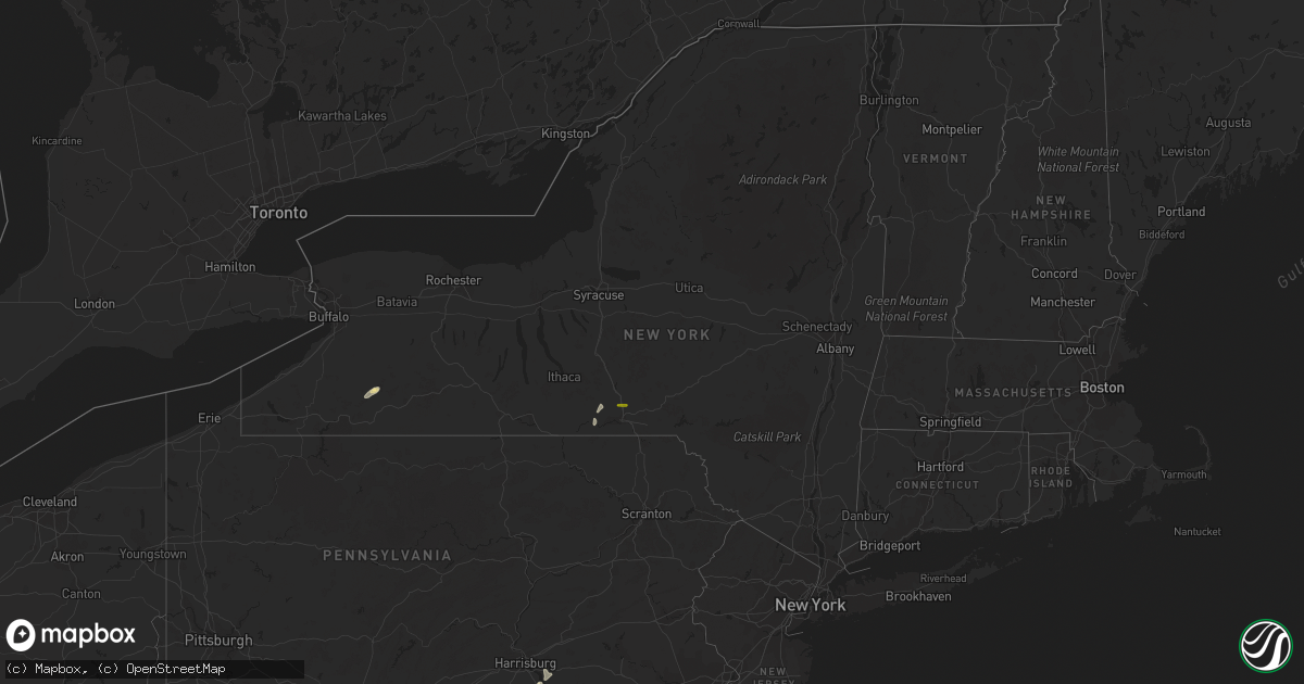
Hail Map in New York on May 18, 2015
Get this storm
May 18 map
$229
one time, instant access
Download today. No call, no setup
Keep the $229
Bought the map and want the full workflow? Apply the entire $229 to a subscription within 7 days. None of it is wasted.
Every map, not just this one
This buys you this map. Subscription and you get every map we run, in the markets you choose from a few cities to whole states to nationwide. Plus real-time alerts the moment a storm fires.
Contact data
Name, contact info, occupancy, even credit band for addresses in the footprint. You go from where it hit to who to call.
Become the source they trust
Unlimited branding weather history reports on demand. You already have the documented answer ready for the property owner, and you are the one who showed up with it.
Property data and RoofTrace estimates
Pull up any address you have got, its value and the exact code rules for that jurisdiction, straight from One Click Code. Then RoofTrace estimates the squares, pitch, and roof value, priced the way you price.
Storm reports in New York
New York
| Date | Description |
|---|---|
| 05/18/20156:41 PM CDT | Trees and power lines down |
| 05/18/20156:41 PM CDT | Trees and power lines down |
| 05/18/20156:24 PM CDT | Trees and wires down. |
| 05/18/20156:22 PM CDT | Trees and wires down. |
| 05/18/20156:17 PM CDT | Trees and wires down. |
| 05/18/20156:17 PM CDT | Trees and wires down. |
| 05/18/20156:16 PM CDT | Trees and wires down. |
| 05/18/20156:10 PM CDT | Trees and power lines down |
| 05/18/20156:05 PM CDT | Trees and power lines down |
| 05/18/20155:57 PM CDT | Trees and wires down. |
| 05/18/20155:46 PM CDT | Trees and power lines down |
| 05/18/20155:25 PM CDT | Tree and wires down...power outages reported |
| 05/18/20154:57 PM CDT | Trees and wires down. |
| 05/18/20154:05 PM CDT | Golf ball sized hail reported on rt 81 just north of bgm |
| 05/17/20157:20 PM CDT | Tree partly across route 248. |
All States Impacted by Hail Map on May 18, 2015
Cities Impacted by Hail Map on May 18, 2015
- Midway, TX
- Leona, TX
- Centerville, TX
- Causey, NM
- Rogers, NM
- Smyrna, GA
- Marietta, GA
- Moriarty, NM
- Estancia, NM
- Mosquero, NM
- Rusk, TX
- Eldorado, TX
- Goldthwaite, TX
- Oakley, ID
- Hico, TX
- Iredell, TX
- Anton, TX
- Moody, TX
- Tinnie, NM
- Durant, OK
- Mead, OK
- San Augustine, TX
- Chireno, TX
- Pine Apple, AL
- Franklinville, NY
- Troy, TX
- Encino, NM
- Vaughn, NM
- Cleveland, TN
- Tucumcari, NM
- Conchas Dam, NM
- Lufkin, TX
- Elkhart, TX
- Laneville, TX
- Morris, GA
- House, NM
- Castell, TX
- Llano, TX
- Kennard, TX
- Oberlin, LA
- Reeves, LA
- Mittie, LA
- Kinder, LA
- Lovington, NM
- Pecos, TX
- Melrose, NM
- Floyd, NM
- Taiban, NM
- Bainbridge, GA
- Ozona, TX
- Robert Lee, TX
- Madill, OK
- North Zulch, TX
- Pottsboro, TX
- Wells, TX
- Alto, TX
- Hext, TX
- Menard, TX
- Brady, TX
- Pollok, TX
- Gatesville, TX
- San Angelo, TX
- Mertzon, TX
- Christoval, TX
- Jemez Springs, NM
- Fort Sumner, NM
- Mcalister, NM
- Mentone, TX
- Reklaw, TX
- Jacksonville, TX
- Garden City, TX
- Stephenville, TX
- New Ulm, TX
- Cat Spring, TX
- Bellville, TX
- Corona, NM
- Big Lake, TX
- Carrizozo, NM
- Columbus, TX
- Wolfforth, TX
- Manchester, PA
- York, PA
- York Haven, PA
- Tatum, NM
- Roswell, NM
- Natchitoches, LA
- Sterling City, TX
- Iraan, TX
- Jal, NM
- Belen, NM
- Midland, TX
- Barnhart, TX
- Coyanosa, TX
- McCamey, TX
- Goodfellow Afb, TX
- Fort Stockton, TX
- Midkiff, TX
- Barstow, TX
- Crane, TX
- Imperial, TX
- Balmorhea, TX
- Milnesand, NM
- Pep, NM
- Melvin, TX
- Port Allen, LA
- Valley Spring, TX
- Collbran, CO
- Kosse, TX
- Ropesville, TX
- Lubbock, TX
- Clovis, NM
- Grady, NM
- Groveton, TX
- Trinity, TX
- Post, TX
- San Saba, TX
- Tahoka, TX
- Mableton, GA
- Austell, GA
- Powder Springs, GA
- Cherokee, TX
- Madisonville, TX
- Crockett, TX
- Lovelady, TX
- Pitkin, LA
- Bluff Dale, TX
- Glen Rose, TX
- Walnut Springs, TX
- Briggs, TX
- Mexia, TX
- Newberg, OR
- Broadview, NM
- Hereford, TX
- Loving, NM
- Lampasas, TX
- Meadow, TX
- Laurel, DE
- Weimar, TX
- Declo, ID
- Hanover, PA
- Littlestown, PA
- Eddy, TX
- Monticello, GA
- Santa Rosa, NM
- Edison, GA
- Atlanta, GA
- Portales, NM
- Texico, NM
- Climax, GA
- Delmar, DE
- Carlsbad, TX
- Blountstown, FL
- Mansfield, GA
- Draper, UT
- Meridian, TX
- Cranfills Gap, TX
- Tishomingo, OK
- Blackwell, TX
- Apalachin, NY
- Owego, NY
- Ray City, GA
- Adel, GA
- Nashville, GA
- Hahira, GA
- Barney, GA
- Cairo, GA
- Georgetown, GA
- Whigham, GA
- Eden, UT
- Monahans, TX
- Las Vegas, NV
- Dry Creek, LA
- Grant, LA
- Shelbyville, TX
- Yeso, NM
- Florence, TX
- Killeen, TX
- Ardmore, OK
- Quitman, GA
- Dover, PA
- Magna, UT
- West Valley City, UT
- Salt Lake City, UT
- West Jordan, UT
- Newark Valley, NY
- Endicott, NY
- Justiceburg, TX
- Mannsville, OK
- Roff, OK
- Franklin, TX
- Denison, TX
- Sherman, TX
- Burley, ID
- Red Oak, GA
- Bryan, TX
- Cedar Valley, UT
- Farwell, TX
- Maryneal, TX
- Diboll, TX
- Middletown, PA
- Bainbridge, PA
- Elizabethtown, PA
- Holden, LA
- Charleston, TN
- Pennington, TX
- Mcdonald, NM
- Salado, TX
- Rutledge, GA
- Sugartown, LA
- Deridder, LA
- Robeline, LA
- Forest Home, AL
- Greenville, AL
- Douglass, TX
- Nacogdoches, TX
- Jay, FL
- Morven, GA
- Fitzhugh, OK
- Raton, NM
- Gause, TX
- Bells, TX
- Whitewright, TX
- Binghamton, NY
- Castle Creek, NY
- Whitney Point, NY


