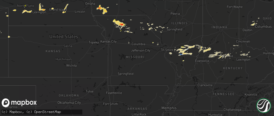
Hail Map in Missouri on May 16, 2026
The weather event in Missouri on May 16, 2026 includes Hail, Wind, and Tornado maps. 11 states and 896 cities were impacted and suffered possible damage. The total estimated number of properties impacted is 34,502.
Want more than just the map?
Turn this storm into a full workflow.
- Owner + property data so you know who to knock
- OnDemand branded weather history reports to win the "did we even have hail?" argument
- RoofTrace estimate so reps stop guessing numbers at the door
Bought this map? Upgrade within 7 days and we'll credit the $230. (10-15 min setup call)
Hail
Wind
Tornado
34,502
Estimated number of impacted properties by a 1.00" hail or larger6,605
Estimated number of impacted properties by a 1.75" hail or larger1,931
Estimated number of impacted properties by a 2.50" hail or largerStorm reports in Missouri
Missouri
| Date | Description |
|---|---|
| 05/16/20266:55 PM CDT | Social media report. Time estimated from radar. |
| 05/16/20266:43 PM CDT | Nws damage survey team confirmed a shortlived ef0 tornado developed within a severe supercell thunderstorm at 6:43 pm cdt on saturday 5/16/2026. This tornado began appr |
| 05/16/20266:41 PM CDT | Social media report. Time estimated from radar. |
| 05/16/20266:41 PM CDT | Picture of tree damage. |
| 05/16/20266:37 PM CDT | Downed wires and power outages near 60th street. Time estimated from radar. |
| 05/16/20266:34 PM CDT | Mping report of damaged power pole near u.s. Highway 65 and route z. Time estimated from radar. |
| 05/16/20266:31 PM CDT | Report of tree down on hwy dd 1 mile east of shafter mo. Time estimated from radar. |
| 05/16/20266:30 PM CDT | Social media report. Damaged windshields. Time estimated from radar. |
| 05/16/20266:29 PM CDT | Social media report. Time estimated from radar. |
| 05/16/20266:28 PM CDT | Damage to outbuildings along clark drive west of browning mo. Time estimated from radar. |
| 05/16/20266:28 PM CDT | Nws damage survey team confirmed an ef1 tornado in northwestern linn county missouri saturday 5/16/2026 north and east of shafter... Mo. This tornado began at 6:28 pm c |
| 05/16/20266:22 PM CDT | Nws damage survey team confirmed an ef0 tornado in northwest linn county... Mo saturday 5/16/2026. This tornado developed at 6:22 pm between arbor dr. And beacon rd. On |
| 05/16/20266:15 PM CDT | Golf ball to baseball size hail. |
| 05/16/20266:12 PM CDT | 6 inch tree limbs knocked down. |
| 05/16/20265:48 PM CDT | Downed wires and power outages near 16th street. Time estimated from radar. |
| 05/16/20265:48 PM CDT | Social media report. Time confirmed from radar. |
| 05/16/20265:37 PM CDT | Social media report. Severe damage to multiple vehicles. Time estimated from radar. |
| 05/16/20265:37 PM CDT | Social media report. Time estimated from radar. |
| 05/16/20265:36 PM CDT | Downed power lines and power outages near 40th street. Time confirmed from radar. |
| 05/16/20265:33 PM CDT | Social media report. Several trees... Limbs... And wires down in laredo. Time estimated from radar. |
| 05/16/20265:31 PM CDT | Social media report... Photo... And measurement. Time estimated from radar. |
| 05/16/20265:31 PM CDT | A local report indicates 1.50 inch wind near 1 N Trenton |
| 05/16/20265:31 PM CDT | Social media report. Time estimated from radar. |
| 05/16/20265:29 PM CDT | Personal weather station recorded. |
| 05/16/20265:29 PM CDT | Social media report. Time estimated from radar. |
| 05/16/20265:26 PM CDT | A local report indicates 2.00 inch wind near 3 N Trenton |
| 05/16/20265:24 PM CDT | Social media report. Time estimated from radar. |
| 05/16/20265:20 PM CDT | Downed tree at a residence on town and country lane. Time estimated from radar. |
| 05/16/20265:20 PM CDT | Social media report. Time estimated from radar. |
| 05/16/20265:17 PM CDT | Chaser reports baseball size hail south of trenton along hwy 65 via social media. |
| 05/16/20265:16 PM CDT | Social media report. Time estimated from radar. |
| 05/16/20265:14 PM CDT | A local report indicates 1.00 inch wind near 5 E Bethany |
| 05/16/20265:13 PM CDT | Social media report. Time estimated from radar. |
| 05/16/20265:12 PM CDT | Report from mping: quarter |
| 05/16/20265:11 PM CDT | A local report indicates 1.75 inch wind near 2 E Trenton |
| 05/16/20265:11 PM CDT | A local report indicates 1.25 inch wind near 2 ESE Trenton |
| 05/16/20265:02 PM CDT | A local report indicates 1.00 inch wind near 4 E Trenton |
| 05/16/20265:01 PM CDT | A local report indicates 1.50 inch wind near 4 ESE Bethany |
| 05/16/20264:59 PM CDT | Power pole leaned over and downed wires near u.s. Highway 65. Time estimated from radar. |
| 05/16/20264:59 PM CDT | Report from mping: half dollar |
| 05/16/20264:58 PM CDT | A local report indicates 1.25 inch wind near 3 SSE Bethany |
| 05/16/20264:55 PM CDT | Social media report. Time estimated from radar. |
| 05/16/20264:49 PM CDT | A local report indicates 1.00 inch wind near 2 N Bethany |
| 05/16/20264:42 PM CDT | Social media report. Damaged windshield. Time estimated from radar. |
| 05/16/20264:39 PM CDT | A local report indicates 1.00 inch wind near 2 SSW Tindall |
| 05/16/20264:29 PM CDT | Social media report. Time estimated from radar. |
| 05/16/20264:22 PM CDT | Social media report. Time estimated from radar. |
| 05/15/202611:47 PM CDT | Social media report. Time estimated from radar. |
| 05/15/202611:23 PM CDT | Social media report. Time estimated from radar. |
| 05/15/202610:42 PM CDT | Social media report. Minor damage to vehicle. Time estimated from radar. |
| 05/15/202610:34 PM CDT | Time estimated from radar. |
| 05/15/202610:13 PM CDT | Private weather sensor. |
| 05/15/202610:06 PM CDT | Social media report. Time estimated from radar. |
| 05/15/20269:05 PM CDT | Social media report. Time estimated from radar. |
| 05/15/20268:46 PM CDT | Several reports of downed wires north of king city. Time estimated from radar. |
| 05/15/20268:37 PM CDT | Mping report of downed tree limbs near u.s. Highway 136. Time estimated from radar. |
| 05/15/20268:25 PM CDT | A local report indicates 2.00 inch wind near 1 SE Albany |
| 05/15/20268:20 PM CDT | Social media report. Time estimated from radar. |
| 05/15/20268:18 PM CDT | Field flooded from torrential rainfall as well. Time estimated from radar. |
| 05/15/20268:15 PM CDT | Social media report. Time estimated from radar. |
| 05/15/20268:11 PM CDT | A local report indicates 1.00 inch wind near Albany |
| 05/15/20268:10 PM CDT | Downed wires and power outages near routes n and t. Time estimated from radar. |
| 05/15/20268:08 PM CDT | Report from mping: quarter |
| 05/15/20268:03 PM CDT | Social media report. Time estimated from radar. |
| 05/15/20268:01 PM CDT | Social media report. Time estimated from radar. |
| 05/15/20267:59 PM CDT | Social media report. Time confirmed from radar. |
| 05/15/20267:59 PM CDT | Social media report. Time estimated from radar. |
| 05/15/20267:59 PM CDT | Large tree limb down near norton street. Time based on social media report and confirmed from radar. |
| 05/15/20267:59 PM CDT | Social media report. Time estimated from radar. |
| 05/15/20267:59 PM CDT | Social media report. Time estimated from radar. |
| 05/15/20267:58 PM CDT | Video from trained spotter on social media shows severe caliber winds along i-35 near eagleville mo. |
| 05/15/20267:57 PM CDT | Mping reports of trees and limbs down near 140th street. Time estimated from radar. |
| 05/15/20267:57 PM CDT | Social media report. Downed tree limbs in town. Time estimated from radar. |
| 05/15/20267:56 PM CDT | Mping report of damaged power pole near u.s. Highway 136. Time confirmed from radar. |
| 05/15/20267:42 PM CDT | Downed wires near county road 164. Time estimated from radar. |
| 05/15/20267:41 PM CDT | Social media report. Large trees down southeast of hatfield. Time estimated from radar. |
| 05/15/20267:38 PM CDT | Social media report. Time estimated from radar. |
| 05/15/20267:34 PM CDT | Tree uprooted near trenton lower lake. Time estimated from radar and social media report. |
| 05/15/20267:32 PM CDT | Social media report. Time estimated from radar. |
| 05/15/20267:30 PM CDT | Downed wires and power outages near route b. Time estimated from radar. |
| 05/15/20267:22 PM CDT | Social media report. Time estimated from radar. |
| 05/15/20267:20 PM CDT | Social media report. Time estimated from radar. |
| 05/15/20267:16 PM CDT | A local report indicates 1.00 inch wind near Sheridan |
| 05/15/20267:15 PM CDT | Social media video of large tree limb down on mo hwy 139. Time estimated from radar. |
| 05/15/20267:09 PM CDT | Pws measured 58 mph. Pws reported it at 0732... But radar suggests 0709pm cdt is more accurate. |
All States Impacted by Hail Map on May 16, 2026
Cities Impacted by Hail Map on May 16, 2026
- North Vernon, IN
- Urbana, OH
- Saint Paris, OH
- Springfield, OH
- Saint Anthony, IN
- Huntingburg, IN
- Ferdinand, IN
- Celestine, IN
- Holland, IN
- Eckerty, IN
- Dale, IN
- Schnellville, IN
- Birdseye, IN
- Oblong, IL
- Sumner, IL
- Nelson, MO
- Carrollton, KY
- Vevay, IN
- Madison, IN
- Cable, OH
- Saint Meinrad, IN
- Bristow, IN
- Mechanicsburg, OH
- Canaan, IN
- Blackwater, MO
- Bennington, IN
- Taswell, IN
- English, IN
- Flat Rock, IL
- Bridgeport, IL
- Lawrenceville, IL
- Richwood, OH
- Saint Croix, IN
- Petersburg, IN
- Grantsburg, IN
- Rising Sun, IN
- Florence, IN
- Truxton, MO
- Bellflower, MO
- Moscow Mills, MO
- Old Monroe, MO
- Irwin, OH
- Milford Center, OH
- Silex, MO
- Hawk Point, MO
- Troy, MO
- Winfield, MO
- Jasper, IN
- Bethlehem, KY
- Lockport, KY
- Patriot, IN
- Riceville, IA
- Chester, IA
- McIntire, IA
- Stamping Ground, KY
- Ludlow, MO
- Gilliam, MO
- Slater, MO
- Corinth, KY
- Owenton, KY
- Utica, MO
- Hale, MO
- Chillicothe, MO
- Marshall, MO
- Sadieville, KY
- Cynthiana, KY
- Georgetown, KY
- Dawn, MO
- Salisbury, MO
- Sumner, MO
- Rothville, MO
- Mendon, MO
- Brookfield, MO
- Marceline, MO
- Pittsfield, IL
- Mount Olivet, KY
- Carlisle, KY
- Paris, KY
- Brooksville, KY
- Lock Springs, MO
- Meadville, MO
- Payson, IL
- Winchester, IL
- Meredosia, IL
- Arenzville, IL
- Beardstown, IL
- Gallatin, MO
- Shelbyville, MO
- Jamesport, MO
- Virginia, IL
- Laclede, MO
- Liberty, IL
- Sharpsburg, KY
- Emden, MO
- Bluffs, IL
- Ashland, IL
- Clayton, IL
- Linneus, MO
- Chula, MO
- Timewell, IL
- Palmyra, MO
- Trenton, MO
- Purdin, MO
- Hannibal, MO
- Bucklin, MO
- Mount Sterling, IL
- Quincy, IL
- French Lick, IN
- Winigan, MO
- New Boston, MO
- Paoli, IN
- Versailles, IL
- Hardinsburg, IN
- Milltown, IN
- Marengo, IN
- Plainville, IL
- Barry, IL
- Baylis, IL
- Bethel, MO
- Leonard, MO
- Edina, MO
- Taylor, MO
- La Grange, MO
- Knox City, MO
- Monticello, MO
- Canton, MO
- Mendon, IL
- Ursa, IL
- Coatsburg, IL
- Mulkeytown, IL
- Benton, IL
- Mount Carmel, IL
- Ramah, CO
- Hazleton, IN
- Allendale, IL
- Simla, CO
- Browning, MO
- Saint Francisville, IL
- Matheson, CO
- Monroe City, IN
- Decker, IN
- Vincennes, IN
- Smithton, IL
- Freeburg, IL
- Belleville, IL
- Limon, CO
- Aviston, IL
- Trenton, IL
- Wheatland, IN
- Washington, IN
- Jameson, MO
- Highland, IL
- Pocahontas, IL
- Vandalia, IL
- Patoka, IL
- New Athens, IL
- Vernon, IL
- Carlyle, IL
- Mascoutah, IL
- Germantown, IL
- Albers, IL
- Breese, IL
- Alma, IL
- Kinmundy, IL
- Calhan, CO
- Montgomery, IN
- Bruceville, IN
- Bicknell, IN
- Corydon, IN
- Loogootee, IN
- Saint Peter, IL
- Bartelso, IL
- Beckemeyer, IL
- Sandoval, IL
- Odin, IL
- Wellfleet, NE
- Dickens, NE
- Cannelburg, IN
- Hoyleton, IL
- Centralia, IL
- Salem, IL
- Ragsdale, IN
- Farina, IL
- Lanesville, IN
- Georgetown, IN
- Corning, IA
- Prescott, IA
- North Platte, NE
- Aurora, NE
- New Hampton, MO
- Bethany, MO
- Mount Vernon, IL
- Albany, MO
- Walnut Hill, IL
- Kell, IL
- Dix, IL
- Hugo, CO
- Peru, IA
- Lexington, NE
- Eddyville, NE
- Imogene, IA
- Woodlawn, IL
- Coffey, MO
- Central, IN
- Mauckport, IN
- Louisville, IL
- Depauw, IN
- Sumner, NE
- Marysville, OH
- Nashville, IL
- Gilman City, MO
- Villisca, IA
- Stanton, IA
- Bedford, KY
- Plainville, IN
- Battletown, KY
- West Baden Springs, IN
- Truro, IA
- Edgewood, IL
- Genoa, CO
- Pekin, IN
- Palmyra, IN
- Emerson, IA
- Brush, CO
- Red Oak, IA
- Iuka, IL
- Texico, IL
- New Salisbury, IN
- Ramsey, IN
- Clarinda, IA
- Woodstock, OH
- Ashley, IL
- Zanesfield, OH
- West Liberty, OH
- Pattonsburg, MO
- Bluford, IL
- Arriba, CO
- Ravenwood, MO
- Grant, NE
- Spickard, MO
- Martinsville, MO
- Green Castle, MO
- Green City, MO
- Milan, MO
- Akron, CO
- Bradshaw, NE
- Hampton, NE
- Xenia, IL
- Fredericksburg, IN
- Laredo, MO
- New Market, IA
- Elizabeth, IN
- Overton, NE
- Du Bois, IL
- Princeton, MO
- Saint Charles, IA
- Flora, IL
- Richview, IL
- Mason City, NE
- Madrid, NE
- Louisville, KY
- Hillrose, CO
- Clay City, IL
- Henderson, NE
- Nodaway, IA
- Oconto, NE
- New Albany, IN
- Polk, NE
- Maxwell, NE
- Noble, IL
- Maywood, NE
- Keenes, IL
- Benedict, NE
- Johnsonville, IL
- Salem, IN
- Holyoke, CO
- Atwood, CO
- Galt, MO
- Gravity, IA
- West Liberty, IL
- Stanberry, MO
- Newton, IL
- Ingraham, IL
- Olney, IL
- Merino, CO
- Kanorado, KS
- New Middletown, IN
- Ridgeway, MO
- Amherst, CO
- Sims, IL
- Stromsburg, NE
- Osceola, NE
- Clarksville, IN
- Floyds Knobs, IN
- Sailor Springs, IL
- Glenview, KY
- Prospect, KY
- Jeffersonville, IN
- Dundas, IL
- Flagler, CO
- Curtis, NE
- Miller, NE
- Wayne City, IL
- Burlington, CO
- Elliott, IA
- Sterling, CO
- Moorefield, NE
- Brady, NE
- Ravenna, NE
- Shelton, NE
- Humphreys, MO
- Broken Bow, NE
- Elm Creek, NE
- Amherst, NE
- Champion, NE
- Iliff, CO
- Griswold, IA
- Lenox, IA
- Sharpsburg, IA
- Bedford, IA
- Joes, CO
- Cairo, NE
- Farnam, NE
- Elsie, NE
- Buckner, KY
- Crestwood, KY
- La Grange, KY
- Claremont, IL
- Sellersburg, IN
- Fairfield, IL
- Geff, IL
- Kirk, CO
- Seibert, CO
- Creston, IA
- Masonic Home, KY
- Goshen, KY
- Ansley, NE
- Fleming, CO
- Lineville, IA
- Boelus, NE
- Rockville, NE
- Simpsonville, KY
- Fisherville, KY
- Finchville, KY
- Golden Gate, IL
- Clearfield, IA
- Goodland, KS
- Vona, CO
- York, NE
- Peetz, CO
- Padroni, CO
- Gothenburg, NE
- Silver Creek, NE
- Wheeling, MO
- Pewee Valley, KY
- Barnhill, IL
- Cainsville, MO
- Columbus, NE
- Shelby, NE
- Wallace, NE
- Cozad, NE
- Winona, KS
- Ellery, IL
- Albion, IL
- Carmi, IL
- Grayville, IL
- Burnt Prairie, IL
- Stratton, CO
- Browns, IL
- Corydon, IA
- Allerton, IA
- Bethune, CO
- Essex, IA
- Humeston, IA
- Eminence, KY
- Garden Grove, IA
- Pleasanton, NE
- Loup City, NE
- Litchfield, NE
- Smithfield, KY
- Edson, KS
- Idalia, CO
- Willow Island, NE
- Saint Francis, KS
- Wray, CO
- Pleasureville, KY
- Central City, NE
- Archer, NE
- Chapman, NE
- Platte Center, NE
- Crossville, IL
- Owensville, IN
- Griffin, IN
- Diagonal, IA
- Colby, KS
- Sidney, NE
- Duncan, NE
- Monroe, NE
- Benton, IA
- Blockton, IA
- Brewster, KS
- Levant, KS
- McDonald, KS
- Bird City, KS
- Scotia, NE
- Ord, NE
- Frankfort, KY
- Venango, NE
- Palmer, NE
- New Harmony, IN
- Westerville, NE
- Riverdale, NE
- Kearney, NE
- Hopkins, MO
- Immokalee, FL
- Poseyville, IN
- Arapahoe, CO
- Wallace, KS
- Weskan, KS
- Imperial, NE
- Humphrey, NE
- Creston, NE
- Comstock, NE
- North Loup, NE
- Mount Ayr, IA
- Redding, IA
- Lake Panasoffkee, FL
- Wolbach, NE
- Greeley, NE
- Elmo, MO
- Braddyville, IA
- Clearmont, MO
- Sheridan, MO
- Eustis, NE
- Fullerton, NE
- Kellerton, IA
- Plymouth, NE
- Jansen, NE
- Beatrice, NE
- De Witt, NE
- Sharon Springs, KS
- Gibbon, NE
- Newman Grove, NE
- Belgrade, NE
- Cedar Rapids, NE
- Hayes Center, NE
- Stanton, NE
- Madison, NE
- Hatfield, MO
- Grant City, MO
- Rising City, NE
- Elwood, NE
- Worth, MO
- Arcadia, NE
- Lamoni, IA
- Eagleville, MO
- Elgin, NE
- Swanton, NE
- Agenda, KS
- Clyde, KS
- Gem, KS
- Rexford, KS
- Ashton, NE
- Rock Port, MO
- Gentry, MO
- Stockville, NE
- Denver, MO
- Parnell, MO
- Mercer, MO
- Davis City, IA
- Blythedale, MO
- Branford, FL
- Bell, FL
- Breda, IA
- Maryville, MO
- Pickering, MO
- Atwood, KS
- Oakley, KS
- Monument, KS
- Smithfield, NE
- Wood River, NE
- Wilber, NE
- Hallam, NE
- Crete, NE
- Clatonia, NE
- Burlington Junction, MO
- Labelle, FL
- Moore Haven, FL
- Oakdale, NE
- Petersburg, NE
- Cuba, KS
- Clifton, KS
- Tilden, NE
- Meadow Grove, NE
- Primrose, NE
- Hamburg, IA
- Dwight, NE
- Ulysses, NE
- Bellwood, NE
- Haddam, KS
- David City, NE
- Elba, NE
- Hoxie, KS
- Bertrand, NE
- Albion, NE
- Skidmore, MO
- Oberlin, KS
- Palisade, NE
- Belleville, KS
- Clyde, MO
- Brainard, NE
- Norfolk, NE
- Selden, KS
- Grainfield, KS
- Grinnell, KS
- Loomis, NE
- Alda, NE
- McCook, NE
- Morrowville, KS
- Conception Junction, MO
- Pickrell, NE
- Denton, NE
- Mahaska, KS
- Shenandoah, IA
- Grand Island, NE
- Guilford, MO
- Barnard, MO
- Lindsay, NE
- Brownell, KS
- Campbell, NE
- Bladen, NE
- Doniphan, NE
- Darlington, MO
- Cortland, NE
- McFall, MO
- Milford, NE
- Pleasant Dale, NE
- Lincoln, NE
- King City, MO
- Conception, MO
- Indianola, NE
- Danbury, NE
- Lebanon, NE
- Wilsonville, NE
- Roseland, NE
- Holstein, NE
- Holdrege, NE
- Narka, KS
- Fairbury, NE
- Linn, KS
- Endicott, NE
- Glenvil, NE
- Hastings, NE
- Seward, NE
- Weston, NE
- Pierce, NE
- Hoskins, NE
- Tarkio, MO
- Westboro, MO
- Norton, KS
- Peru, NE
- Giltner, NE
- Phillips, NE
- Reynolds, NE
- Cambridge, NE
- Trumbull, NE
- Malcolm, NE
- Valparaiso, NE
- Morland, KS
- Saint Libory, NE
- Raymond, NE
- Ayr, NE
- Garland, NE
- Hubbell, NE
- Washington, KS
- Wahoo, NE
- Ceresco, NE
- Bartley, NE
- Park, KS
- Quinter, KS
- Collyer, KS
- Wakeeney, KS
- Penokee, KS
- Hill City, KS
- Dresden, KS
- Norcatur, KS
- Arapahoe, NE
- Holbrook, NE
- Almena, KS
- Hendley, NE
- Beaver City, NE
- Oxford, NE
- Stamford, NE
- Edison, NE
- Prairie View, KS
- Orleans, NE
- Long Island, KS
- Phillipsburg, KS
- Lenora, KS
- Funk, NE
- Farragut, IA
- Riverton, IA
- Blue Hill, NE
- Harris, MO
- Filley, NE
- Watson, MO
- Maysville, MO
- Munden, KS
- Marquette, NE
- Waverly, IA
- Tripoli, IA
- Belvidere, NE
- Graham, MO
- Rea, MO
- Sumner, IA
- Tobias, NE
- Western, NE
- Clarks, NE
- Dorchester, NE
- Ashland, NE
- Waverly, NE
- Bee, NE
- Bogue, KS
- Palco, KS
- Damar, KS
- Plainville, KS
- Stockton, KS
- Alma, NE
- Atlanta, NE
- Readlyn, IA
- Denver, IA
- Maitland, MO
- Lawrence, NE
- Minden, NE
- Newtown, MO
- Pollock, MO
- Chester, NE
- Guide Rock, NE
- Deweese, NE
- Fairfield, NE
- Natoma, KS
- Woodston, KS
- Glade, KS
- Agra, KS
- Kensington, KS
- Gaylord, KS
- Republican City, NE
- Kirwin, KS
- Axtell, NE
- Naponee, NE
- Hildreth, NE
- Bloomington, NE
- Wilcox, NE
- Davey, NE
- Sutton, NE
- Ithaca, NE
- Juniata, NE
- Upland, NE
- Hebron, NE
- Yutan, NE
- Adams, NE
- Nelson, NE
- Superior, NE
- Sterling, NE
- Grafton, NE
- Fairmont, NE
- Kenesaw, NE
- Burr, NE
- Douglas, NE
- Waterloo, NE
- Fairfax, MO
- Weatherby, MO
- Fairbank, IA
- Gilead, NE
- Edgar, NE
- Oelwein, IA
- Gretna, NE
- Hazleton, IA
- Cedar, KS
- Athol, KS
- Franklin, NE
- Riverton, NE
- Smith Center, KS
- Heartwell, NE
- McCool Junction, NE
- Hordville, NE
- Oak, NE
- Shickley, NE
- Strang, NE
- Milligan, NE
- Waco, NE
- Bolckow, MO
- Unionville, MO
- Geneva, NE
- Carleton, NE
- Alexandria, NE
- Friend, NE
- Beaver Crossing, NE
- Bruning, NE
- Lebanon, KS
- Red Cloud, NE
- Mankato, KS
- Burr Oak, KS
- Inavale, NE
- Esbon, KS
- Utica, NE
- Gresham, NE
- Staplehurst, NE
- Exeter, NE
- Surprise, NE
- Goehner, NE
- Cordova, NE
- Ohiowa, NE
- Tecumseh, NE
- Blue Springs, NE
- Manchester, IA
- Dundee, IA
- Greenwood, NE
- Davenport, NE
- Jewell, KS
- Inland, NE
- Dyersville, IA
- Earlville, IA
- Greeley, IA
- New Vienna, IA
- Edgewood, IA
- Memphis, NE
- Union Star, MO
- Charlestown, IN
- Westport, KY
- Bethlehem, IN
- Pendleton, KY
- New Washington, IN
- Republic, KS
- Peterson, IA
- Hardy, NE
- Courtland, KS
- Webber, KS
- Deshler, NE
- Sulphur, KY
- Campbellsburg, KY
- New Castle, KY
- Ruskin, NE
- Cook, NE
- Beloit, KS
- Oregon, MO
- Hunter, KS
- Sylvan Grove, KS
- Turners Station, KY
- Sanders, KY
- Worthville, KY
- Ghent, KY
- Glen Elder, KS
- Cawker City, KS
- Randall, KS
- Clay Center, NE
- Harvard, NE
- Concordia, KS
- Norway, KS
- Byron, NE
- Formoso, KS
- Scandia, KS
- Jamestown, KS
- Aurora, KS
- Glasco, KS
- Daykin, NE
- Arbela, MO
- Luray, MO
- Memphis, MO
- Rutledge, MO
- Gorin, MO
- Luxemburg, IA
- Guttenberg, IA
- Ong, NE
- Saronville, NE
- Saint Paul, NE
- Dannebrog, NE
- Palmer, KS
- Morganville, KS
- Green, KS
- Clay Center, KS
- Talmage, NE
- Brock, NE
- Johnson, NE
- Delphos, KS
- Novinger, MO
- Fillmore, MO
- Miltonvale, KS
- Wakefield, KS
- Diller, NE
- Hollenberg, KS
- Steele City, NE
- Hanover, KS
- Greenleaf, KS
- Randolph, KS
- Odell, NE
- Lucerne, MO
- Savannah, MO
- Nebraska City, NE
- Julian, NE
- Leonardville, KS
- Barnes, KS
- Bremen, KS
- Waterville, KS
- Martell, NE
- Rosendale, MO
- Auburn, NE
- Wymore, NE
- Marysville, KS
- Beattie, KS
- Oketo, KS
- Helena, MO
- Roca, NE
- Sprague, NE
- Hickman, NE
- Panama, NE
- Liberty, NE
- Bennet, NE
- Lewiston, NE
- Barneston, NE
- Crab Orchard, NE
- Summerfield, KS
- Firth, NE
- Blue Rapids, KS
- Steinauer, NE
- Home, KS
- Burchard, NE
- Virginia, NE
- Frankfort, KS
- Pawnee City, NE
- Elk Creek, NE
- Westmoreland, KS
- Centralia, KS
- Axtell, KS
- Table Rock, NE
- Onaga, KS
- Vermillion, KS
- Olsburg, KS
- Baileyville, KS
- Bern, KS
- Humboldt, NE
- Du Bois, NE
- Corning, KS
- Goff, KS
- Seneca, KS
- Havensville, KS
- Oneida, KS
- Syracuse, NE
- Sabetha, KS
- Stella, NE
- Nemaha, NE
- Verdon, NE
- Shubert, NE
- Dawson, NE
- Brownville, NE
- Soldier, KS
- Circleville, KS
- Falls City, NE
- Wetmore, KS
- Morrill, KS
- Holton, KS
- Fairview, KS
- Powhattan, KS
- Salem, NE
- Netawaka, KS
- Whiting, KS
- Hiawatha, KS
- White Cloud, KS
- Rulo, NE
- Horton, KS
- Craig, MO
- Effingham, KS
- Highland, KS
- Denton, KS
- Muscotah, KS
- Troy, KS
- Lancaster, KS
- Everest, KS
- Robinson, KS
- Hull, IA
- Rock Valley, IA
- Forest City, MO
- Mound City, MO
- Atchison, KS
- Bendena, KS
- Cummings, KS
- Nortonville, KS
- Valley Falls, KS
- Hershey, NE
- Sutherland, NE
- Paxton, NE
- Columbus, WI
- Fall River, WI
- Rio, WI
- Hazard, NE
- Farwell, NE


