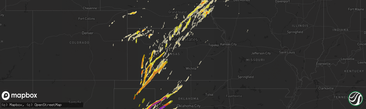
Hail Map in Kansas on May 16, 2017
The weather event in Kansas on May 16, 2017 includes Hail map. 9 states and 844 cities were impacted and suffered possible damage. The total estimated number of properties impacted is 12,989.
Want more than just the map?
Turn this storm into a full workflow.
- Owner + property data so you know who to knock
- OnDemand branded weather history reports to win the "did we even have hail?" argument
- RoofTrace estimate so reps stop guessing numbers at the door
Bought this map? Upgrade within 7 days and we'll credit the $230. (10-15 min setup call)
Hail
12,989
Estimated number of impacted properties by a 1.00" hail or larger7,109
Estimated number of impacted properties by a 1.75" hail or larger3,670
Estimated number of impacted properties by a 2.50" hail or largerStorm reports in Kansas
Kansas
| Date | Description |
|---|---|
| 05/16/20176:54 PM CDT | Trained spotter reports 60 mph winds on kansas highway 18. |
| 05/16/20176:32 PM CDT | Rain wrapped tornado nw of bucklin. |
| 05/16/20176:23 PM CDT | Mostly dime sized hail with a few quarters mixed in. |
| 05/16/20176:19 PM CDT | Estimated 50-60 mph. |
| 05/16/20176:16 PM CDT | A local report indicates 1.00 inch wind near 2 S FT. DODGE |
| 05/16/20176:07 PM CDT | Reports of windows broken. |
| 05/16/20176:07 PM CDT | Report of golf ball sized hail and broken car windows while driving. |
| 05/16/20176:06 PM CDT | Mping report. |
| 05/16/20175:55 PM CDT | Report of several power poles snapped. |
| 05/16/20175:55 PM CDT | Via social media. |
| 05/16/20175:55 PM CDT | Several out buildings damaged. Part of a machine shed blown out into the field. |
| 05/16/20175:52 PM CDT | A local report indicates 1.00 inch wind near 6 N ESBON |
| 05/16/20175:52 PM CDT | A local report indicates 3.00 inch wind near 4 S MINNEOLA |
| 05/16/20175:50 PM CDT | Path of hail from road 67 and rt 8 to about road 74. Quarters and half dollars measured. |
| 05/16/20175:50 PM CDT | A local report indicates 2.50 inch wind near 6 S MINNEOLA |
| 05/16/20175:49 PM CDT | Several vehicles and mobile offices damaged. |
| 05/16/20175:49 PM CDT | A local report indicates 2.75 inch wind near 8 S MINNEOLA |
| 05/16/20175:46 PM CDT | Hail went from road 68 and rd 8 to about rd 74. Size was from quarters to half dollars. |
| 05/16/20175:44 PM CDT | Pkwnd 71 mph at 548 pm. |
| 05/16/20175:39 PM CDT | A local report indicates 1.00 inch wind near BURR OAK |
| 05/16/20175:38 PM CDT | Pkwnd 75 mph 543 pm. |
| 05/16/20175:38 PM CDT | A local report indicates 1.50 inch wind near KISMET |
| 05/16/20175:34 PM CDT | A local report indicates 1.75 inch wind near 4 NE HAYNE |
| 05/16/20175:22 PM CDT | A local report indicates 64 MPH wind near HILL CITY |
| 05/16/20175:05 PM CDT | A local report indicates 1.00 inch wind near 5 E MEADE STATE PARK |
| 05/16/20175:03 PM CDT | Penny up to quarter size. |
| 05/16/20175:01 PM CDT | Delayed report. |
| 05/16/20174:45 PM CDT | A local report indicates 2.50 inch wind near 8 N GARDEN CITY |
| 05/16/20174:34 PM CDT | A local report indicates 2.00 inch wind near GARDEN CITY |
| 05/16/20174:34 PM CDT | Via social media. |
| 05/16/20174:29 PM CDT | A local report indicates 3.00 inch wind near HOLCOMB |
| 05/16/20174:29 PM CDT | A local report indicates 1.75 inch wind near HOLCOMB |
| 05/16/20174:28 PM CDT | A local report indicates 2.50 inch wind near 1 E HOLCOMB |
| 05/16/20174:22 PM CDT | A local report indicates 64 MPH wind near HILL CITY |
| 05/16/20174:22 PM CDT | Hail varied in size from nickels to quarters. |
| 05/16/20174:22 PM CDT | A local report indicates 1.00 inch wind near 1 SE CATHERINE |
| 05/16/20174:17 PM CDT | Golfball to approaching baseball sized hail. |
| 05/16/20174:10 PM CDT | A local report indicates 1.50 inch wind near 7 SSW UTICA |
| 05/16/20173:54 PM CDT | A local report indicates 1.00 inch wind near 5 S BEELER |
| 05/16/20173:48 PM CDT | A local report indicates 3.00 inch wind near 12 WNW ENGLEWOOD |
| 05/16/20173:32 PM CDT | Via social media. |
| 05/16/20173:30 PM CDT | Golfball to hen egg sized hail. |
| 05/16/20173:30 PM CDT | A local report indicates 1.75 inch wind near SATANTA |
| 05/16/20173:27 PM CDT | A local report indicates 1.00 inch wind near 5 SE CIMARRON |
| 05/16/20173:27 PM CDT | A local report indicates 2.00 inch wind near 3 E CIMARRON |
| 05/16/20173:11 PM CDT | A local report indicates 1.00 inch wind near 6 NNW THE HAGGARD ELEVA |
| 05/16/20176:52 AM CDT | A local report indicates 1.00 inch wind near HUNTER |
| 05/16/201712:05 AM CDT | Very heavy rain also occurring at this time. |
| 05/15/20179:20 PM CDT | A local report indicates 1.50 inch wind near 6 WNW ATWOOD |
| 05/15/20179:03 PM CDT | A local report indicates 1.50 inch wind near 1 ESE ALEXANDER |
| 05/15/20178:56 PM CDT | A local report indicates 1.00 inch wind near 2 SW BREWSTER |
| 05/15/20178:49 PM CDT | A local report indicates 1.75 inch wind near HERNDON |
| 05/15/20178:48 PM CDT | A local report indicates a tornado near 1 NE SUSANK |
| 05/15/20178:40 PM CDT | Damage report of power lines and trees down from tornado that went through earlier. Time based on previous report. |
| 05/15/20178:39 PM CDT | A local report indicates a tornado near 1 NW HOISINGTON |
| 05/15/20178:28 PM CDT | A local report indicates a tornado near 6 NW GREAT BEND |
| 05/15/20178:21 PM CDT | Power poles down. |
| 05/15/20178:16 PM CDT | A local report indicates 1.00 inch wind near 9 N JETMORE |
| 05/15/20178:13 PM CDT | A local report indicates 1.00 inch wind near 8 N JETMORE |
| 05/15/20178:11 PM CDT | A local report indicates a tornado near PAWNEE ROCK |
| 05/15/20178:10 PM CDT | Spotter reports tree and road sign damage near pawnee rock. |
| 05/15/20177:59 PM CDT | Pivot flipped/twisted. This is the initial touchdown of long-track ef3 tornado starting in pawnee county and ending in barton county. |
| 05/15/20177:49 PM CDT | Delayed report: emergency management reports a swath of straight line wind damage from roughly 1 mile south of belleville to roughly 3 miles northeast of belleville. Ou |
| 05/15/20177:48 PM CDT | A local report indicates 1.00 inch wind near MCDONALD |
| 05/15/20177:27 PM CDT | A local report indicates 1.00 inch wind near 7 NNE ATWOOD |
| 05/15/20177:25 PM CDT | A local report indicates 1.00 inch wind near 3 E KINSLEY |
| 05/15/20177:20 PM CDT | Via social media. |
| 05/15/20177:02 PM CDT | A local report indicates 60 MPH wind near 3 ENE ASH GROVE |
All States Impacted by Hail Map on May 16, 2017
Cities Impacted by Hail Map on May 16, 2017
- Bennington, NE
- Alma, NE
- Holdrege, NE
- Oberlin, KS
- Wheeler, TX
- Shamrock, TX
- Iron River, WI
- Northfield, MN
- Randolph, MN
- Thedford, NE
- Seneca, NE
- Valentine, NE
- Garden City, TX
- Atwood, KS
- Sterling City, TX
- Bird City, KS
- Copeland, KS
- Irwin, IA
- Defiance, IA
- Manilla, IA
- Minneola, KS
- Plattsmouth, NE
- Concordia, KS
- Agenda, KS
- Belleville, KS
- Edson, KS
- Goodland, KS
- Plains, KS
- Sublette, KS
- Montezuma, KS
- Kismet, KS
- Arcadia, WI
- New Auburn, WI
- Midland, TX
- Utica, KS
- Beeler, KS
- Gretna, NE
- Denison, IA
- Catharine, KS
- Spur, TX
- Girard, TX
- Paducah, TX
- Post, TX
- Seymour, TX
- Snyder, TX
- Dickens, TX
- Jayton, TX
- Fluvanna, TX
- Crowell, TX
- Justiceburg, TX
- Cimarron, KS
- Pelican Lake, WI
- Mazeppa, MN
- Pine Island, MN
- Millville, MN
- Zumbro Falls, MN
- Logan, IA
- Fowler, KS
- Dennison, MN
- Springfield, NE
- Roscoe, TX
- Holcomb, KS
- Garden City, KS
- Ulysses, KS
- Sayre, OK
- Marengo, WI
- Mellen, WI
- Erick, OK
- Maryneal, TX
- Turpin, OK
- Balko, OK
- Whitehall, WI
- Lonsdale, MN
- Webster, MN
- Clintonville, WI
- Eyota, MN
- Dover, MN
- Lincoln, NE
- Canadian, TX
- Reydon, OK
- Briscoe, TX
- Ozona, TX
- Ashland, NE
- Raymond, NE
- Waverly, NE
- Davey, NE
- Ceresco, NE
- Webber, KS
- Republic, KS
- Courtland, KS
- Boyceville, WI
- Wheeler, WI
- Whittemore, IA
- Algona, IA
- Lone Rock, IA
- Burt, IA
- Louisville, NE
- Syracuse, NE
- Elmwood, NE
- Murdock, NE
- Nehawka, NE
- Weeping Water, NE
- Murray, NE
- Avoca, NE
- Greenwood, NE
- Eagle, NE
- Manley, NE
- Unadilla, NE
- Palmyra, NE
- Alvo, NE
- Wahoo, NE
- Weston, NE
- Goltry, OK
- Redfield, IA
- Linden, IA
- Jetmore, KS
- Forgan, OK
- Medford, WI
- Withee, WI
- Lublin, WI
- Abbotsford, WI
- Edgar, WI
- Marathon, WI
- Stetsonville, WI
- Curtiss, WI
- Merrill, WI
- Athens, WI
- Dorchester, WI
- Owen, WI
- Thorp, WI
- Ransom, KS
- Arnold, KS
- Duke, OK
- Ridgeland, WI
- Scott City, KS
- Big Spring, TX
- Nelson, WI
- Catawba, WI
- South Saint Paul, MN
- Lake Elmo, MN
- Houlton, WI
- Inver Grove Heights, MN
- Newport, MN
- Lakeland, MN
- Rosemount, MN
- Stillwater, MN
- Bayport, MN
- Hudson, WI
- Cottage Grove, MN
- Afton, MN
- Saint Paul, MN
- Saint Paul Park, MN
- Alton, KS
- Portis, KS
- Gaylord, KS
- Osborne, KS
- Natoma, KS
- Elgin, MN
- Oronoco, MN
- Rochester, MN
- Wellington, TX
- Elcho, WI
- Pearson, WI
- Crete, NE
- Pleasant Dale, NE
- Dresden, KS
- Jennings, KS
- Selden, KS
- Plainfield, WI
- Almond, WI
- Taloga, OK
- Vici, OK
- Beaver, OK
- Fountain City, WI
- Maiden Rock, WI
- Stockholm, WI
- Hastings, NE
- Sweetwater, OK
- Faribault, MN
- Farmington, MN
- Montgomery, MN
- Kilkenny, MN
- Dundas, MN
- Herndon, KS
- Ludell, KS
- Chetek, WI
- Herbster, WI
- Port Wing, WI
- Akron, CO
- Sylvan Grove, KS
- Texola, OK
- Nickerson, NE
- Cedar Bluffs, NE
- Arlington, NE
- Fremont, NE
- Colon, NE
- Meade, KS
- Leedey, OK
- Matfield Green, KS
- Cassoday, KS
- El Dorado, KS
- Manning, IA
- Hammond, WI
- Kennan, WI
- Glen Flora, WI
- Bruce, WI
- Westboro, WI
- Hawkins, WI
- Baldwin, WI
- Tomahawk, WI
- Weyerhaeuser, WI
- Ladysmith, WI
- Prentice, WI
- Tony, WI
- Ogema, WI
- Brantwood, WI
- Sheldon, WI
- Downing, WI
- Conrath, WI
- New Richmond, WI
- Glenwood City, WI
- Dallas, WI
- Holcombe, WI
- Tripoli, WI
- Rib Lake, WI
- Wesley, IA
- Britt, IA
- Woden, IA
- Ellis, KS
- Clinton, OK
- Elk City, OK
- Canute, OK
- Quail, TX
- Butler, OK
- Carter, OK
- Spring Valley, WI
- Elmwood, WI
- Linneus, MO
- Honey Creek, IA
- Missouri Valley, IA
- Crescent, IA
- Fort Calhoun, NE
- Neola, IA
- Omaha, NE
- Mankato, KS
- Burr Oak, KS
- Superior, NE
- Nelson, NE
- Guide Rock, NE
- Childress, TX
- Mclean, TX
- Clarendon, TX
- Mobeetie, TX
- Esbon, KS
- Hardy, NE
- Byron, NE
- Forest City, IA
- Venango, NE
- Madrid, NE
- Elsie, NE
- Grant, NE
- Deshler, NE
- Hebron, NE
- Glenwood, IA
- Gruver, TX
- Spearman, TX
- Baird, TX
- Brule, WI
- Gleason, WI
- Rhinelander, WI
- Crandon, WI
- Goodhue, MN
- Lake City, MN
- Roca, NE
- Walton, NE
- Amorita, OK
- Burlington, OK
- Frederick, OK
- Ford, KS
- Leland, IA
- Hoisington, KS
- Lu Verne, IA
- Hemingford, NE
- Ingalls, KS
- Purdum, NE
- Ainsworth, NE
- Brewster, NE
- Lamesa, TX
- Fairmont, NE
- McCool Junction, NE
- Liberal, KS
- Kenyon, MN
- Audubon, IA
- Templeton, IA
- Frontenac, MN
- Cannon Falls, MN
- Arkansaw, WI
- Ellsworth, WI
- Bay City, WI
- Durand, WI
- Hampton, MN
- Plum City, WI
- Pepin, WI
- Hastings, MN
- Red Wing, MN
- Welch, MN
- Hager City, WI
- Nerstrand, MN
- Underwood, IA
- Bellevue, NE
- La Vista, NE
- Ithaca, NE
- Elkhorn, NE
- Malcolm, NE
- Waterloo, NE
- Boys Town, NE
- Pacific Junction, IA
- Yutan, NE
- Council Bluffs, IA
- Stapleton, NE
- Aspermont, TX
- O'Brien, TX
- Rule, TX
- Munday, TX
- Rochester, TX
- Knox City, TX
- Old Glory, TX
- Rolfe, IA
- Amery, WI
- Deer Park, WI
- Star Prairie, WI
- Barron, WI
- Clayton, WI
- Turtle Lake, WI
- Rice Lake, WI
- Osceola, WI
- Cameron, WI
- Clear Lake, WI
- Somerset, WI
- Garfield, KS
- Lewis, KS
- Kinsley, KS
- Perry, IA
- Plymouth, NE
- Jansen, NE
- Harrold, TX
- Stanton, TX
- Byron, MN
- Otis, KS
- Great Bend, KS
- Albert, KS
- Olmitz, KS
- Larned, KS
- Casey, IA
- Guthrie Center, IA
- Adair, IA
- Argonne, WI
- Alexander, KS
- Bazine, KS
- La Crosse, KS
- Ness City, KS
- Beloit, KS
- Hunter, KS
- Barnard, KS
- Lincoln, KS
- Clifton, KS
- Clyde, KS
- Greensburg, KS
- Spearville, KS
- Hardesty, OK
- Wright, KS
- Englewood, KS
- Bucklin, KS
- Perryton, TX
- Dodge City, KS
- Offerle, KS
- Seward, NE
- Independence, WI
- Blair, WI
- Osseo, WI
- Neillsville, WI
- Le Sueur, MN
- Cleveland, MN
- Mankato, MN
- Alma Center, WI
- Saint Peter, MN
- Minnesota City, MN
- Cochrane, WI
- Eleva, WI
- Alma, WI
- Wabasha, MN
- Hixton, WI
- Taylor, WI
- Kellogg, MN
- Warsaw, MN
- Altura, MN
- Le Center, MN
- Ettrick, WI
- Kasota, MN
- Mondovi, WI
- Fairchild, WI
- Morristown, MN
- Humbird, WI
- Merrillan, WI
- Strum, WI
- Madison Lake, MN
- Black River Falls, WI
- Geneva, NE
- Firth, NE
- Panama, IA
- Ames, NE
- York, NE
- Kennard, NE
- Friend, NE
- Panama, NE
- Carleton, NE
- Beaver Crossing, NE
- Brainard, NE
- Waco, NE
- Malmo, NE
- Silver City, IA
- Edgar, NE
- South Bend, NE
- Garland, NE
- Lebanon, KS
- Martell, NE
- Milligan, NE
- Denton, NE
- Woodbine, IA
- Hooper, NE
- Downs, KS
- Milford, NE
- Bennet, NE
- Hallam, NE
- Dunlap, IA
- Papillion, NE
- Ohiowa, NE
- Chester, NE
- Persia, IA
- Cordova, NE
- Prague, NE
- Mead, NE
- Ong, NE
- Hickman, NE
- De Witt, NE
- Utica, NE
- Beatrice, NE
- Valley, NE
- Bruning, NE
- Valparaiso, NE
- Red Cloud, NE
- Herman, NE
- Sutton, NE
- Strang, NE
- Goehner, NE
- Dwight, NE
- Alexandria, NE
- Exeter, NE
- Formoso, KS
- Mineola, IA
- Bee, NE
- Blair, NE
- Douglas, NE
- Adams, NE
- Memphis, NE
- Oak, NE
- Cortland, NE
- Davenport, NE
- Belvidere, NE
- Shickley, NE
- Portsmouth, IA
- Pickrell, NE
- Staplehurst, NE
- Atlantic, IA
- Satanta, KS
- Clam Lake, WI
- High Bridge, WI
- Shell Lake, WI
- Cuba, KS
- Anita, IA
- Panora, IA
- Exira, IA
- Spooner, WI
- Webster, WI
- Kanorado, KS
- Fairbury, NE
- Dighton, KS
- Seiling, OK
- Levant, KS
- Colby, KS
- Gail, TX
- Fairview, OK
- Ringwood, OK
- Cleo Springs, OK
- Isabella, OK
- Mangum, OK
- Gould, OK
- Harlan, IA
- Phillips, WI
- Winter, WI
- Cherokee, OK
- Mutual, OK
- Durham, OK
- Jet, OK
- Hammon, OK
- Carmen, OK
- Cheyenne, OK
- Nash, OK
- Chester, OK
- Aline, OK
- Crawford, OK
- Camargo, OK
- Claude, TX
- Helena, OK
- Pampa, TX
- Carrier, OK
- Norcatur, KS
- Cable, WI
- Charles City, IA
- North Platte, NE
- Glenville, MN
- Earling, IA
- Kirkman, IA
- Minden, IA
- Westside, IA
- Westphalia, IA
- Shelby, IA
- Aspinwall, IA
- Big Lake, TX
- McDonald, KS
- Brewster, KS
- Trent, TX
- Merkel, TX
- Park, KS
- Hays, KS
- Brownell, KS
- Woodward, OK
- Fort Supply, OK
- Arapaho, OK
- Turkey, TX
- Memphis, TX
- Lakeview, TX
- Custer City, OK
- Hedley, TX
- Thomas, OK
- Minburn, IA
- Lone Wolf, OK
- Haddam, KS
- Mahaska, KS
- Endicott, NE
- Narka, KS
- McCamey, TX
- Otis, CO
- Maple, WI
- Ira, TX
- Rotan, TX
- Hermleigh, TX
- Irma, WI
- Wilber, NE
- Tuscola, TX
- Blackwell, TX
- Hooker, OK
- Trego, WI
- Danbury, WI
- Caldwell, KS
- Wellington, KS
- Clyde, TX
- Robert Lee, TX
- Hayfield, MN
- Kasson, MN
- Sargeant, MN
- Stewartville, MN
- Midkiff, TX
- Fonda, IA
- Pocahontas, IA
- Juniata, NE
- Joice, IA
- Lake Mills, IA
- Brayton, IA
- Yale, IA
- David City, NE
- Mullinville, KS
- Ashland, WI
- Coldwater, KS
- Burdett, KS
- Rozel, KS
- Doniphan, NE
- Dresser, WI
- Almena, WI
- Bayfield, WI
- Bethune, CO
- Burlington, CO
- Van Wert, IA
- Plainview, MN
- Stanley, WI
- Gilman, WI
- Westbrook, TX
- Armstrong Creek, WI
- Clatonia, NE
- Plainville, KS
- Braham, MN
- Northwood, IA
- Garner, IA
- Plover, IA
- Bradgate, IA
- Crystal Lake, IA
- Havelock, IA
- Ottosen, IA
- Bode, IA
- Emmons, MN
- Mallard, IA
- Thompson, IA
- Sac City, IA
- Newell, IA
- Austin, MN
- West Bend, IA
- Nekoma, KS
- Rush Center, KS
- Alliance, NE
- Deerbrook, WI
- Cordell, OK
- Carnegie, OK
- Waynoka, OK
- Smith Center, KS
- Saint Francis, KS
- Bryant, WI
- Wausau, WI
- Glenvil, NE
- Palmer, KS
- Linn, KS
- Manchester, OK
- Quanah, TX
- Granite, OK
- Reads Landing, MN
- Holyoke, CO
- Haxtun, CO
- Boone, IA
- Glidden, IA
- Churdan, IA
- Carroll, IA
- Lake City, IA
- Lohrville, IA
- Colorado City, TX
- Coahoma, TX
- Colfax, WI
- Laclede, MO
- Roland, IA
- Nevada, IA
- Frederic, WI
- Barronett, WI
- Comstock, WI
- Cumberland, WI
- McCracken, KS
- Liebenthal, KS
- Hanston, KS
- Hugoton, KS
- Ensign, KS
- Story City, IA
- Ames, IA
- Zearing, IA
- Hubbard, IA
- New Providence, IA
- McCallsburg, IA
- McClelland, IA
- Medford, OK
- Sun City, KS
- Dow City, IA
- Gove, KS
- Waseca, MN
- Athol, KS
- Cedar, KS
- Belvue, KS
- Wamego, KS
- Grundy Center, IA
- Eldora, IA
- Collyer, KS
- Quinter, KS
- Gotebo, OK
- Lookeba, OK
- Hydro, OK
- Binger, OK
- Vernon, TX
- Balsam Lake, WI
- Mertzon, TX
- Milltown, WI
- Luck, WI
- Russell, KS
- Treynor, IA
- Antigo, WI
- Linwood, NE
- Victoria, KS
- Woodston, KS
- Hayward, WI
- McCook, NE
- Bunker Hill, KS
- Tyrone, OK
- Mora, MN
- Sutherland, NE
- Lebanon, NE
- Loraine, TX
- Sweetwater, TX
- Nolan, TX
- Tye, TX
- Abilene, TX
- Newcastle, NE
- Pierceville, KS
- Marion, WI
- Rosholt, WI
- Amherst Junction, WI
- Iola, WI
- Tigerton, WI
- Adel, IA
- Circle Pines, MN
- Wakeeney, KS
- Wellsburg, IA
- Steamboat Rock, IA
- Dorchester, NE
- Mason, WI
- Nemaha, IA
- Anson, TX
- Hawley, TX
- Lenora, KS
- Norton, KS
- Clayton, KS
- Glade, KS
- Pickerel, WI
- White Lake, WI
- Odonnell, TX
- Bison, KS
- Springbrook, WI
- Minong, WI
- Gilbert, IA
- Hill City, KS
- Dalbo, MN
- Princeton, MN
- Stanchfield, MN
- Stone Lake, WI
- Lenorah, TX
- Odessa, TX
- Marshfield, WI
- Stratford, WI
- Lakeville, MN
- Mercer, WI
- Knott, TX
- Harrison, NE
- Farnhamville, IA
- Saronville, NE
- Aurora, NE
- Haviland, KS
- Oklaunion, TX
- Hayes Center, NE
- Centuria, WI
- Saint Croix Falls, WI
- Madrid, IA
- Laona, WI
- Massena, IA
- Hobart, OK
- Kimballton, IA
- Pfeifer, KS
- Summit Lake, WI
- Courtland, MN
- Early, IA
- Odebolt, IA
- Lucas, KS
- Dorrance, KS
- Hanska, MN
- New Ulm, MN
- Titonka, IA
- Dunbar, NE
- Gorham, KS
- Stockton, KS
- Crane, TX
- Barnhart, TX
- Marine On Saint Croix, MN
- Roberts, WI
- Cornell, WI
- Boyd, WI
- Culbertson, NE
- Poplar, WI
- Morland, KS
- Coats, KS
- Sawyer, KS
- Lake City, KS
- South Range, WI
- Union, IA
- Osceola, NE
- Diller, NE
- Scribner, NE
- Mountain View, OK
- Gordon, WI
- Simpson, KS
- Glasco, KS
- Jamestown, KS
- Scandia, KS
- Flagler, CO
- Kit Carson, CO
- Park Falls, WI
- Modale, IA
- Amherst, CO
- Phillipsburg, KS
- Long Island, KS
- Leon, KS
- Ogallah, KS
- Solon Springs, WI
- Cairo, NE
- Boelus, NE
- Dannebrog, NE
- Beldenville, WI
- River Falls, WI
- Hancock, WI
- Ogden, IA
- Woodward, IA
- Saint Charles, MN
- Bogue, KS
- Paradise, KS
- Waldo, KS
- Saint Marys, KS
- Emmett, KS
- Fontanelle, IA
- Keystone, NE
- Lakota, IA
- Carlsbad, TX
- San Angelo, TX
- Swanton, NE
- Western, NE
- Daykin, NE
- Prairie Farm, WI
- Saxon, WI
- Brokaw, WI
- Stinnett, TX
- Morse, TX
- White Deer, TX
- Skellytown, TX
- Miami, TX
- Weatherford, OK
- Foss, OK
- Hollis, OK
- Weinert, TX
- Belpre, KS
- Lawrence, NE
- Vail, IA
- Gowrie, IA
- Saint Anthony, IA
- Radcliffe, IA


